
- Home
- Rural Development
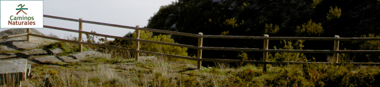
- Nature Trails
- Nature Trails
- Northwest Sector
- La Ribeira Sacra
Ribeira Sacra Nature Trail
Description
Through lands of wine and prayer
The area is probably known as “Ribeira Sacra”, owing to the large number of religious buildings found here. There are 18 monasteries open to visitors, including Monforte de Lemos, and San Estevo de Ribas de Sil, now converted into a Parador.
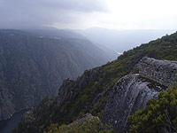
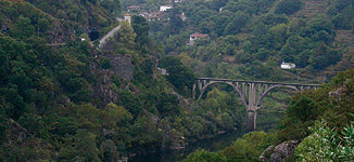
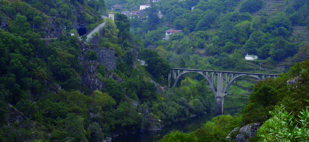
This county is located between the rivers Sil and Miño, the natural boundary between the provinces of Ourense and Lugo. The county capital, established by agreement, is Monforte de Lemos (Lugo). The Ribeira Sacra, famous for its cultural treasures, high biodiversity and wines with denomination of origin, encompasses spectacular landscapes and unique ecosystems like Cañones del Sil.
The Ribeira Sacra Nature Trail consists of several routes:
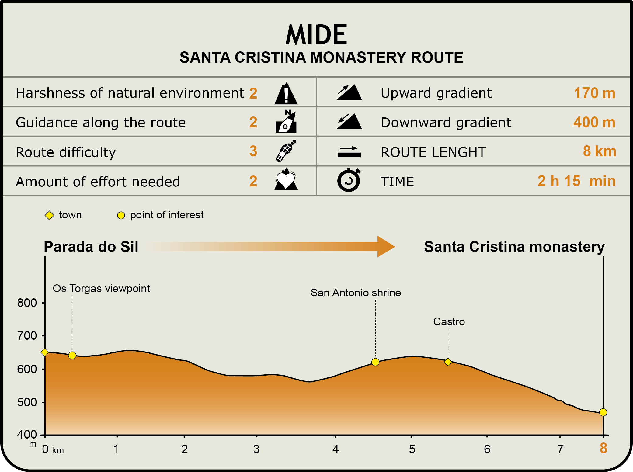
Parada do Sil to Monastery of Santa Cristina Route (8 km):
This route starts at the entrance of the village of Parada do Sil, next to the "O Barquilleiro" memorial monument. From here, it descends between houses, following the white and yellow signs, to the intersection with OU-605. It continue to the right for about 200 m, then turns onto a road to the left leading to Fondodevila.
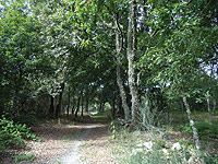
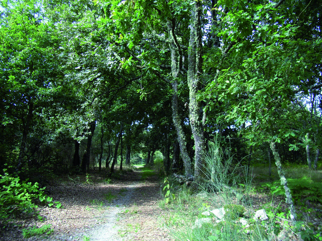
Once in the centre of this small town, past a fountain, the route turns onto a signposted dirt road to the left, and continues through stone walls and centenary chestnut trees (Castanea sativa), until it meets the road to Os Torgas and Balcones de Madrid. The route descends towards an intersection located next to a car park near a soccer field and a recreation area. Although the Nature Trail continues to the left, it is worth the trouble to make a detour to the right and visit Balcones de Madrid, a spectacular natural viewpoint overlooking the canyons of the River Sil.
Continuing straight ahead, the route reaches another intersection, and descends along a very steep gravel track, through pines and oaks (Quercus robur). After crossing several roads and the PRG-98 route, it reaches a wooden bridge. It now begins to climb a cobbled road until it again meets the PRG-98. Past this point, the route begins to descend along an old cobbled road leading to a stone bridge over the PRG-98 route for the third time, whence it heads to Portela along a concrete path.
The route traverses through this town and climbs to the shrine of San Antonio. Here it joins the road to the right that heads to the nearby town of Castro. Leaving behind the town, the route begins a steep climb down a 12% slope to the Monastery of Santa Cristina. The road then continues along a large sharp bend from where there are breath-taking views of the canyons sculpted over millennia by the River Sil. The route continues downhill for about 1 km to the Monastery of Santa Cristina, where the road and the route ends.
The Monastery may be accessed by climbing down a short, stepped path through centenary chestnut trees.
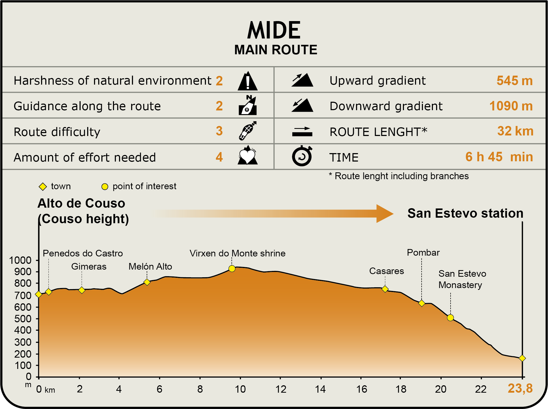
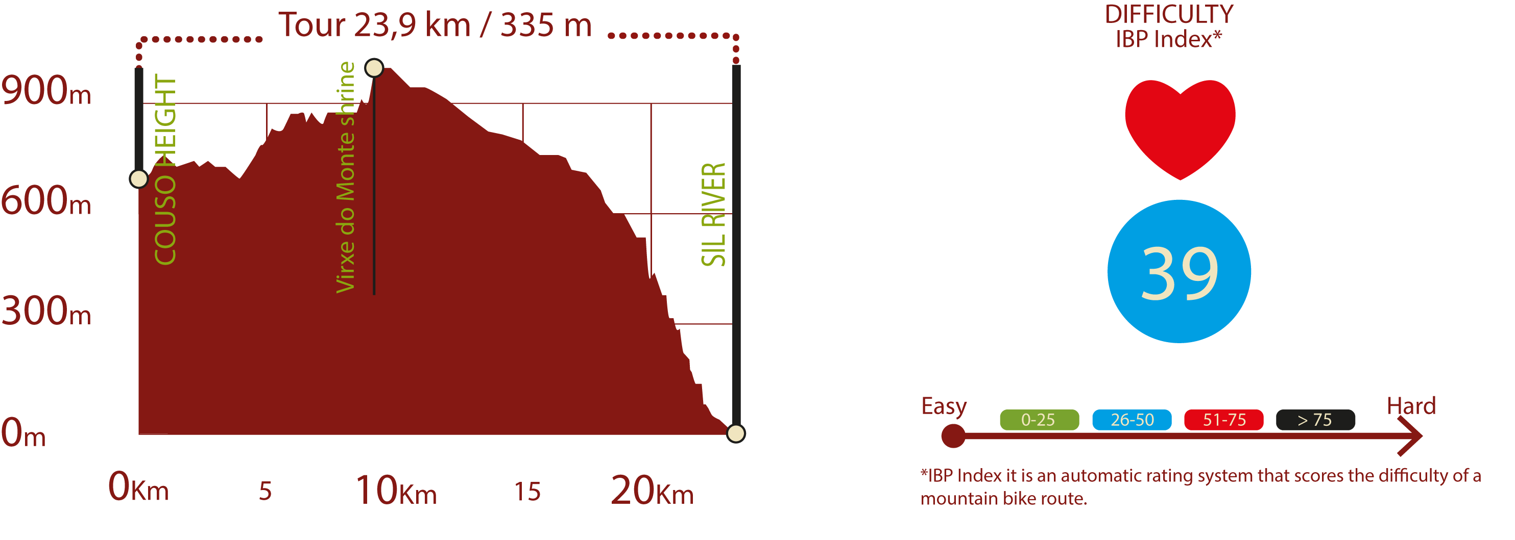
Main Route: Monastery of Santo Estevo and Shrine of Virxen do Monte Route (24 km):
The first half of this route runs in Esgos municipality, and the second half in Nogueira de Ramuín. The route begins at Alto de Couso, and heads north to the town of Meiroás along a small road through pines, oaks, birches, broom and gorse. At the first crossroads, the route turns left to a second intersection, where the Nature Trail continues to the right towards a third crossing where it proceeds straight ahead. The third branch of this Nature Trail, the so-called Meiroás-Melón Baixo Route, starts here to the right. The route passes an intersection and continues to the right for about 300 m, along a narrow gravel path through meadows. The path traverses through the town of Melon Baixo, and heads down from the square to a gravel path via a small flight of stairs.
Taking a right turn at the crossroads, the route heads down the road to Melón Alto. At the entrance to this small town, the route turns right again, behind the bus stop, and continues up the signposted path to a fountain with a watering trough. From here, it leaves the town along a gravel track. It then turns left onto a concrete track that further ahead becomes a narrow bridle path. It reaches another intersection and continues to the right through an oak forest until it reaches a wide gravel road. The route continues to the left, along another branch of the Nature Trail known as "Ruta de los Arcos".
After reaching a stretch that runs over a paved road, the route turns onto a parallel gravel path that heads up a steep slope to the meadow where the shrine of Virxen do Monte can be found. This place has an area with a fountain and several tables to enjoy a well-deserved rest.
The route skirts around the shrine, and turns left onto a gravel road that heads down to the road along which it continues in parallel until it reaches an intersection. Following the gravel track to the left, the route arrives at Nogueira de Ramuín. The track passes in front of a wind farm and seven new intersections to finally reach the town of Casares.
Past the town, the route continues along the road until the first offshoot road to the right. It then heads to the nearby village of Pombar along a gravel track, through gorse and oak trees. It traverses through the streets to reach OU-508. The route continues to climb down, turning on to the first side-track to the left, and heads on to the next crossroads, where it turns right. The road to the left climbs up to the ancient fortress of Penedos do Castro, with magnificent views of the Sil Valley and the Monastery of Santo Estevo.
The trail continues to descend through oaks and chestnuts along a gravel track, and reaches Santo Estevo de Ribas do Sil, a town where the Monastery turned Parador is located.
The route continues towards Santo Estevo station. It heads up the access road, passes through the town, and turns left before leaving the town along a cobbled road. Past a chestnut and oak forest, the route reaches the road and continues parallel to the River Sil to the bridge of Santo Estevo station, where the route ends.
Meiroás - Melón Baixo Route (4,8 km)
The third route of this Nature Trail begins at the level crossing situated 3 km down the Monasterio de Santo Estevo-Ermita Virxen do Monte Route. It turns right onto the road leading to the town square of Meiroás, where there are several “cabazos”, typical Galician granaries. The route then turns left, winds through the town houses, continues along a dirt road, and turns onto the road leading to Xunquiera de Espadanedo at KM 1 of the Route. Immediately after starting down the paved road, the route turns right onto a dirt road.
At the first crossroads, the route heads to the right through meadows and woodlands of oak and birch (Betula sp.) until it reaches a paved road and turns right. It continues along this road, then turns left through a path between stone walls. Past a centenary oak forest, the route begins to climb through gorse (Ulex sp.) and broom patches towards the meadows surrounding the village of Casanova. The Nature Trail continues left along the road, crosses the town square, then turns right, and immediately after, turns left onto a road that runs between stone walls and old oaks and chestnuts.
The route carries on through a young oak forest, until it reaches a wide track, along which it runs for a few metres, then turns onto a downhill path. After crossing a small bridge, it reaches another intersection and turns left onto a path between stone walls that traverses through a lush oak forest to reach the road to Melón Baixo. The route then turns right and reaches the town square where the path ends.
Arcos Route (1,3 km):
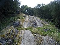
This short alternative begins at the intersection located on the main path or Camino Real de la Ribeira Sacra. The route runs along a stone path, where the ruts tell of the passage of hundreds of wagons, and continues through an oak forest to reach the road leading to Arcos. It then turns left to reach, then cross the town. It continues along a narrow stone path to the right, through meadows and oaks, which leads to the road where this short route ends.
San Xoan de Cachón Route (2,5 km):
The last route included in this Nature Trail begins on the granite path to the Monastery of Santo Estevo de Ribas do Sil. At the crossroads at the edge of the village, the signposted route takes the path to the left that descends between large chestnuts, past the monastery.
It turns left again, then traverses a more or less flat forest populated with oaks, chestnuts, strawberry trees (Arbutus unedo) and cork oaks (Quercus suber). After crossing two wooden bridges over streams, the route reaches a reforestation eucalyptus grove (Eucalyptus sp.). From here, the path winds down a flight of steep stairs towards the road along the River Sil, where this short yet pleasant route ends.
Profile
1- Parada de Sil to Monasterio de Santa Cristina route
2 - Monasterio de Santo Estevo - Ermita Virxen do Monte route
MIDE (Method for the Information of Excursions)
 Harshness of natural environment
- 1. The environment is not risk-free
- 2. There are more than one risk factors
- 3. There are various risk factors
- 4. There are quite a lot of risk factors
- 5. There are many risk factors
 Guidance along the route
- 1. Well defined trails and crossings
- 2. There is a clearly marked trail and signage
- 3. Requires the identification of geographic features and cardinal points
- 4. Requires off-path navigation
- 5. The trail is interrupted by obstacles that have to be gone around
 Route difficulty
- 1. Walking on a flat surface
- 2. Trails with different types of path
- 3. Walking on stepped paths or irregular terrain
- 4. The use of hands or jumping over the terrain is necessary
- 5. The use of hands is required to progress
 Amount of effort needed
- 1. Up to 1 hour of continuous walking
- 2. Between 1 and 3 hours of continuous walking
- 3. Between 3 and 6 hours of continuous walking
- 4. Between 6 and 10 hours of actual walking
- 5. More than 10 hours of continuous walking
Featured
Further information
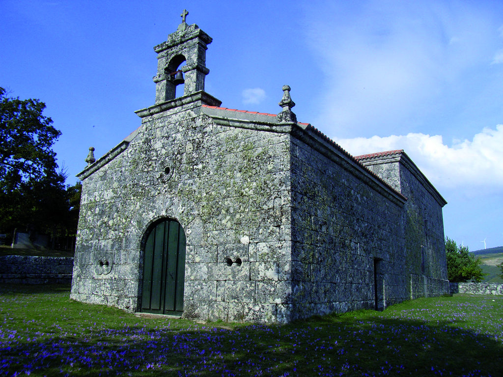
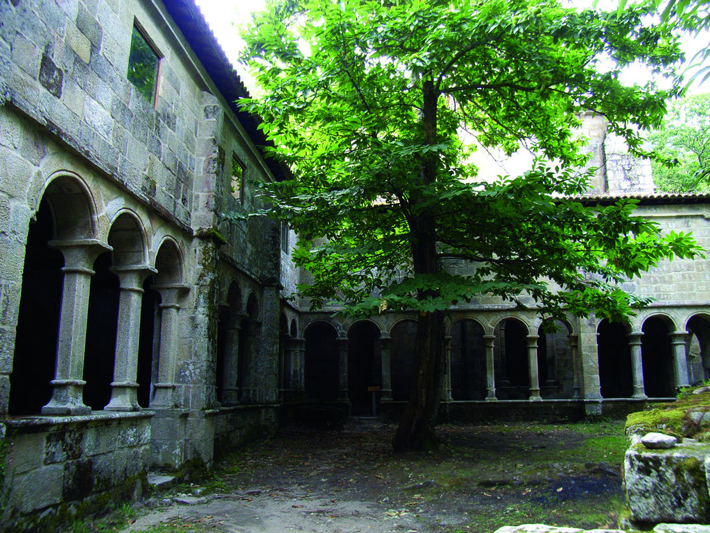
Monastery of Santa Cristina de Ribas de Sil
Located in the village of Parada do Sil, and only a few metres from the River Sil, sits the Monastery in a natural environment of unparalleled beauty, dominated by a dense chestnut forest.
Although much has been said about its ancient origin, the first document that mentions this monastery dates back to the ninth century.
The pure Romanesque church, built in the late 12th century, is a single Latin cross nave with a transept. There are three apses in the east end. The main apse is an extension of the nave, and the two side apses form the arms of the transept.
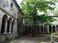
It also has other Romanesque elements, such as the tower and a small portico attached to the façade that gives access to the cloister. Only the two northern Renaissance galleries of the cloister, built in the 16th century, still stand. These galleries are connected via semicircular arches on octagonal chamfered columns.
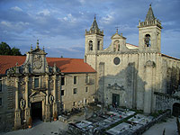
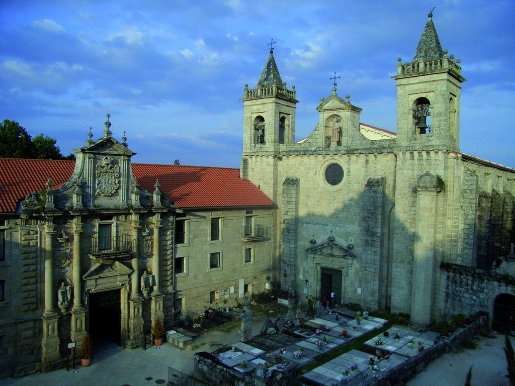
Monastery de Santo Estevo
The Romanesque monastery of Santo Estevo de Ribas de Sil is one of the most important and famous buildings of the Ribeira Sacra. It not only has one of few Romanesque cloisters in Galicia, called "de los Obispos", but was also converted into a Parador in 2004.
The monastic church was built in late Romanesque style. It has three large naves with pointed arches that end in three apses. Interestingly, the two side apses are taller than the one in the centre.
Inside is a remarkable Romanesque pentagonal altarpiece carved in stone. In the centre is Christ flanked by the Apostles under arches.
Although the ground floor is Romanesque, the cloister has heavy buttresses topped with late Gothic pinnacles in order to support the weight of the upper floor. This disrupts the harmony and uniformity of the Romanesque arches. The austere semicircular arches are supported by pairs of columns with slender plain capitals decorated with plant motifs.
Multimedia


Downloads
GPS Downloads
Brochure and Maps
Cyclability
PROFILE & DIFFICULTY
ROAD TYPE & PORTAGES

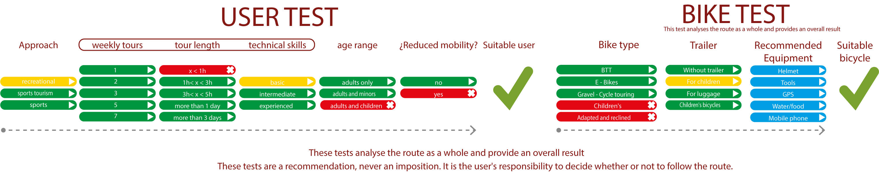
TEST
SAFETY RECOMMENDATIONS
-Sections shared with hikers and agricultural vehicles.
-Transit through the centre of some population centres.
-Downhill section with irregular road surface and shared with hikers from Santo Estevo viewpoint to the river Sil.
GENERAL RECOMMENDATIONS
-Find out about the technical aspects of the route and the weather on the day.
-Take care of the environment. Take care not to disturb animals or damage vegetation. Respect private areas.
-You must give priority to pedestrians and comply with general traffic rules.
-The environment in which you will be riding is open, free to move around and an area where many activities are carried out (sporting, forestry, livestock and agricultural activities). Always have an understanding, prudent, responsible and respectful attitude.