- Home
- Rural Development
- Nature Trails
- Nature Trails
- Central Sector
- Corredor Cáceres-Badajoz
Cáceres- Badajoz corridor Nature Trail
Description
Ponds, Holm-oaks and granite
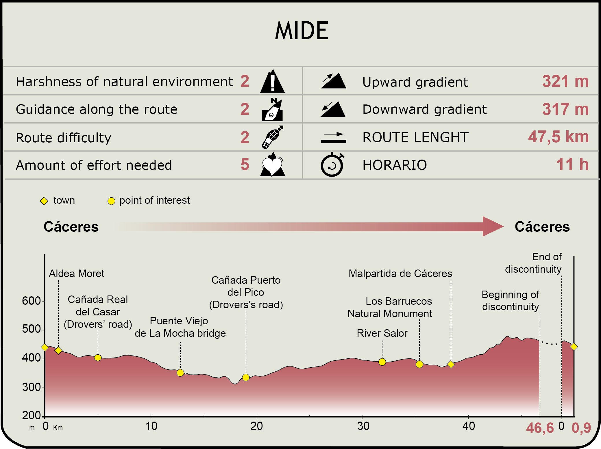
The Cáceres-Badajoz Corridor Nature Trail covers 176.3 km, beginning to the south of the town centre of Cáceres and ending to the west of Valverde de Leganés, approximately 30 km south of the city of Badajoz.
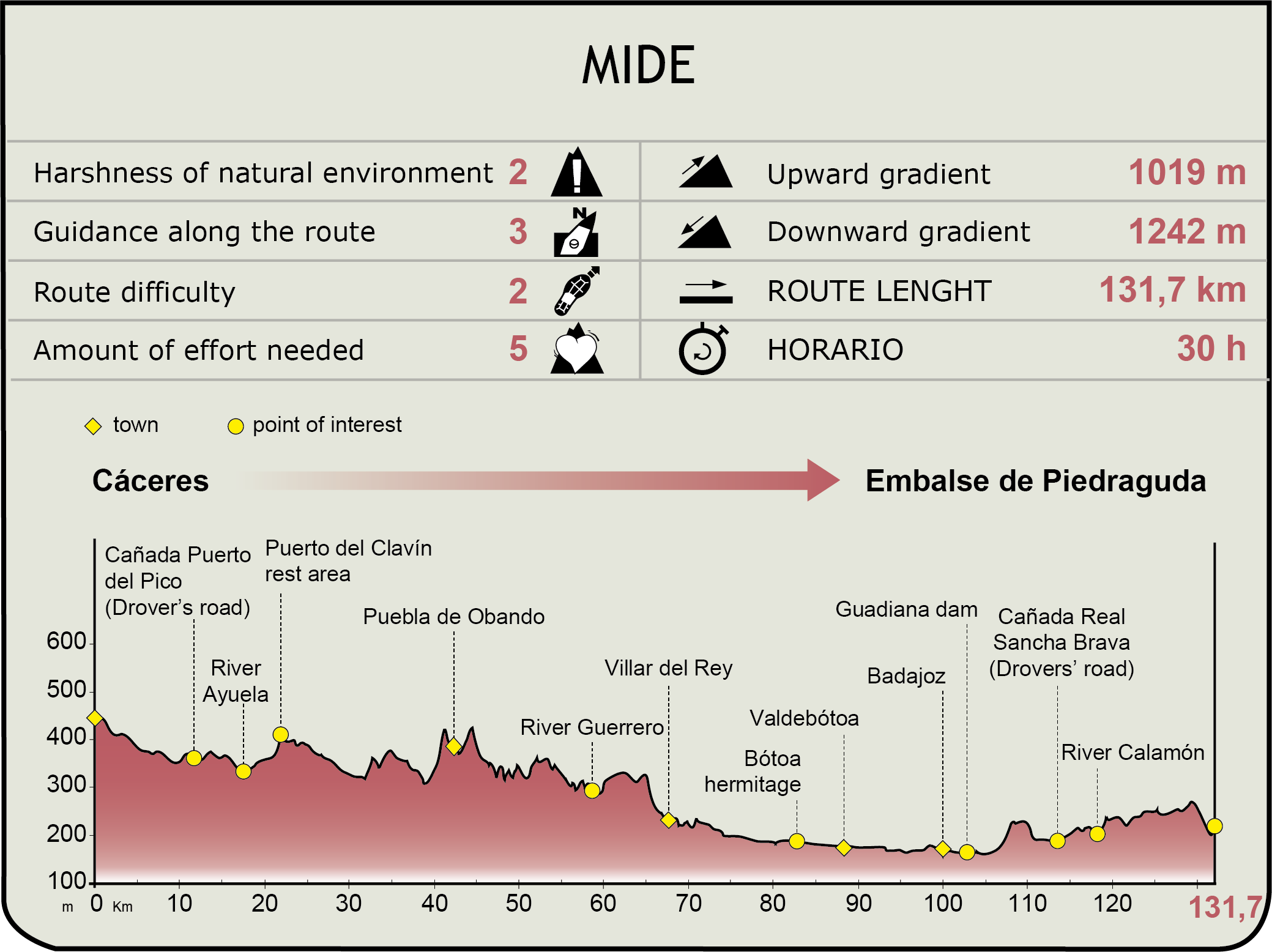
Due to its length, this guide has divided the route into two. The first is a circular 50 km itinerary, which covers the area surrounding the city of Cáceres; while the second runs in a straight line for 126.3 km, joining the cities of Cáceres and Badajoz together, and continues southwards as far as the vicinity of Valverde de Leganés, crossing, on its way, Puebla de Obando and Villar del Rey.
Route 1
Due to its length, this guide has divided the route into two. The first is a circular 50 km itinerary, which covers the area surrounding the city of Cáceres; while the second runs in a straight line for 126.3 km, joining the cities of Cáceres and Badajoz together, and continues southwards as far as the vicinity of Valverde de Leganés, crossing, on its way, Puebla de Obando and Villar del Rey.
Day 1
You begin in a southeasterly direction, leaving on one side an electric substation, to then pass between the houses located further to the south of the city of Cáceres. Cross the Cáceres-Valencia de Alcántara railway track and continue eastwards following the Cañada Real of Casar. Further on, you cross the N-630 highway level with Alcor de Santa Ana, and continue parallel to the latter, leaving a housing estate on your right-hand side. When you reach the River Salor, cross it and change direction towards the south-west, until you come to the Cañada Real of the Puerto del Pico and Miravete. A little further on, the trail turns to the west, crosses the Cáceres-Mérida railway line and carries on until it merges with the EX-100 highway. At this point, this first route crosses the second one, which, on its way from Cáceres, continues in a straight line in a southwesterly direction parallel to the aforementioned highway.
Day 2
This route also continues parallel to the highway, but in the direction of Cáceres, along the Cordel de la Enjarada. It crosses El Campo stream and then turns leftwards, passing over the highway at ground level at the intersection with the trail from La Luz stream and El Lavadero de Lanas Path. Your trail continues along the former route, turning northwards, until it merges with the path of Malpartida de Cáceres, a short while before crossing the River Salor. A little later, it crosses the Celadilla stream and joins a path that leads to El Lavadero de Lanas or the Wool Washhouse, which today has been turned into a Contemporary Art Museum (Museo Vostell-Malpartida). In its surrounding area, you will come to the Barruecos de Abajo reservoir, whose vicinity has been declared a Natural Monument. The uniqueness and beauty of both spots make them worth visiting.
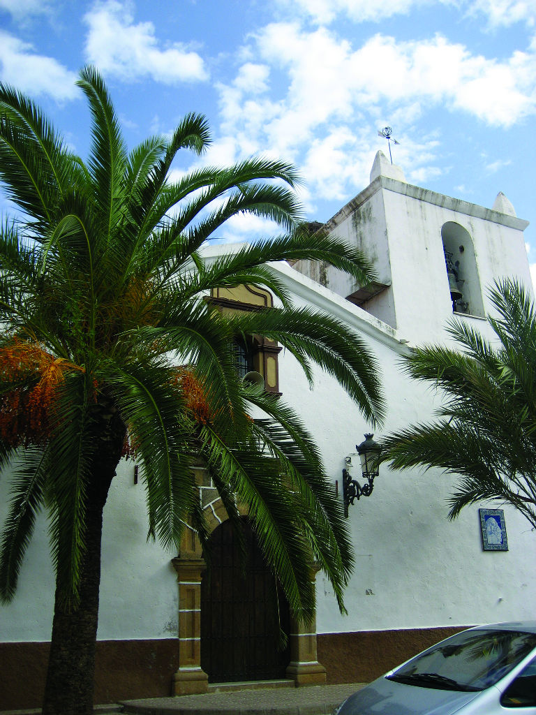
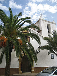
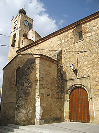
After crossing the stream there, a little further ahead the Nature Trail reaches the town of Malpartida de Cáceres, a must-stop so you can visit its cultural heritage, characterised by its fortress houses, palaces, churches and its variety of unique museums.
From this point onwards, the route continues by bordering the town but without entering it, running around it in a southeasterly direction until it reaches the N-521 highway from Trujillo to Valencia de Alcántara. From here onwards, it continues eastwards, parallel to the latter, crosses the track of the Valencia railway line, as well as the aforementioned highway, to then turn southwards, a short distance before entering the city of Cáceres, where it ends at the same point it began, in the area surrounding the RENFE railway station.
Route 2
Due to its length, this route has been divided into four sections, which are covered in five days:
Section 1. Cáceres - Puebla de Obando (42.3 km)
Day 1
This section of the Nature Trail begins at the same point as Route 1, and a good deal of its itinerary runs along the Cordel de la Enjarada y Segura, in a southwesterly direction. After crossing the track of the Cáceres to Valencia de Alcántara railway line, continue along the aforementioned cordel or path, parallel to Las Muesas stream, until it merges with the EX-100 highway, level with its intersection with the trail to Malpartida. From here, there is a very long parallel section, which passes over El Alcor de Santana stream and a couple of trails, before reaching the River Salor, which it crosses close to the road, continuing alongside it for a long stretch. After leaving on the right the turn-off to El Arroyo de la Luz trail and the Vereda del Lavadero de Lanas or the Wool Washhouse Path (km 12.9), the trail continues in a straight line, close to the highway, as far as the crossroads with Route 1, where it merges with the Cañada Real of the Puerto del Pico and Miravete (km 14.8). From here onwards, it continues along the aforementioned Cañada or drovers’ road and crosses the River Ayuela until it arrives at the riverside of El Gavilán or of El Gaitán.
Day 2
At this point, the drovers’ road breaks away from the highway in a southwesterly direction, changing province and forming part of the municipality of Puebla de Obando (Badajoz), through the Sierra Gorda. A little further ahead, the route comes to this town’s centre where you can visit the parish church of San Ildefonso, which dates back to the 16th century.
Section 2. Puebla de Obando - Villar del Rey (23.2 km)
Day 3
The trail continues through the southwest of Puebla de Obando in a southerly direction as far as the pass of El Zángano, where it merges once again with the EX-100 road. The route runs parallel to this road on its right-hand-side bank for a short section and then turns westwards, entering a thick cork tree grove, in the direction of Villar del Rey. A short while before you get there, cross the BA-157 highway to Puebla de Obando, a town that has been inhabited since Neolithic times, as is evidenced by the large number of dolmens found on the “Leoncillo” estate, where there are also remains of a Roman villa, or that of Peña Hincada, on the Cerro de la Espinosa. Worthy of note in the town centre is the late Gothic (16th-century) parish church of Nuestra Señora del Rosario.
Section 3: Villar del Rey - Badajoz (30.6 km)
Day 4
Once in Villar del Rey, the route crosses the town diametrically in a southwesterly direction, to then leave it close to the Villar del Rey B-road (EX-325). A short distance from the town, you can see a unique landscape formed of large stone slabs and enormous granite rocks that invite you to have a rest and enjoy the spot. From here onwards, the trail continues parallel to the road and to the River Zapatón, which is located more to the west, crossing a very flat landscape of Holm oaks (Quercus ilex).You reach a point where this road joins the EX-110 highway, which carries on to Badajoz. A short while after joining this highway, the trail crosses the road level with the chapel of Nuestra Señora de Botoa and continues parallel to the latter until it crosses the Canal de Montijo. Here, it now runs parallel and very close to the River Gévora along its left bank.
In the vicinity of Badajoz, the route passes below the Madrid highway, crosses the River Gévora and continues southwards once again parallel to the EX-110 highway until, just before reaching Badajoz, it crosses the railway line to enter the city in a southwesterly direction.
Section 4. Badajoz - Piedra Aguda Reservoir (30.2 km)
Day 5
To the west of the city of Badajoz, the trail once again crosses the EX-110 highway, drawing close to the River Guadiana on its right bank. It crosses it downstream via a dam located next to a wastewater treatment plant. From the other bank, it soon joins, on the left, the Cañada of Sancha Brava, which will lead travellers to the end of the route.
A little further ahead, you should cross the EX-107 highway in an easterly direction, and pass through Las Vaguadas housing estate and over the EX-310 highway from Badajoz to Valverde de Leganés, as well as the Calamón stream. From there, continue parallel to the aforementioned stream in a southerly direction along the Dehesilla de Calamón. After crossing the Calamón stream once again and the EX-310 highway level with the housing estate known as Los Pinares de Valverde, which owes its name to the stone pine(Pinus pinea) groves in the area, the trail passes by Los Llanos de Herrera estate and enters a small area where the vegetation changes, where you can see stone pines and Holm-oaks with kermes oak (Quercus coccifera) and turpentine (Pistacia terebinthus)brushwood.
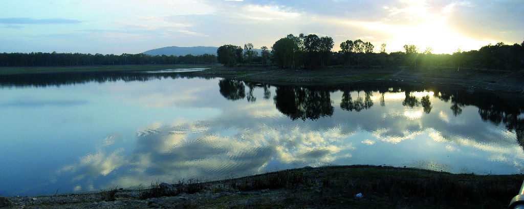
On passing through this vegetation stand, the trail turns leftwards in a southerly direction, and the landscape once again becomes agricultural in nature, with a predominance of dry and olive crops, almost until the end of the route. From here, continue parallel to the EX-310 highway as far as kilometre 19, the point where it crosses it and changes direction to the southeast. In the last section of the route, the trail once again enters an area of cleared Holm oaks and continues like this until the end of the route, next to the River Olivenza and the Piedra Aguda reservoir, 4.1 km to the west of Valverde de Leganés, from where you can contemplate beautiful views.
Profile
Ruta 1
Ruta 2
MIDE (Method for the Information of Excursions)
 Harshness of natural environment
- 1. The environment is not risk-free
- 2. There are more than one risk factors
- 3. There are various risk factors
- 4. There are quite a lot of risk factors
- 5. There are many risk factors
 Guidance along the route
- 1. Well defined trails and crossings
- 2. There is a clearly marked trail and signage
- 3. Requires the identification of geographic features and cardinal points
- 4. Requires off-path navigation
- 5. The trail is interrupted by obstacles that have to be gone around
 Route difficulty
- 1. Walking on a flat surface
- 2. Trails with different types of path
- 3. Walking on stepped paths or irregular terrain
- 4. The use of hands or jumping over the terrain is necessary
- 5. The use of hands is required to progress
 Amount of effort needed
- 1. Up to 1 hour of continuous walking
- 2. Between 1 and 3 hours of continuous walking
- 3. Between 3 and 6 hours of continuous walking
- 4. Between 6 and 10 hours of actual walking
- 5. More than 10 hours of continuous walking
Featured
Further information
Wool washhouse
This old construction, built at the end of the 18th century, is located in the vicinity of the town of Malpartida de Cáceres, and currently houses the Contemporary Art Museum of the Spanish-German artist Wolf Vostell (Vostell-Malpartida Museum).
In its rooms, you will discover countless remains of human activity in the area, ranging from Pre-historic times (painting and engravings) up until recent history (a 16th-century press and 18th and 19th-century sinks), including traits revealing a Roman presence.
In the 19th century, this place consolidated its position as a major wool-washing industry, reaching up to 80,000 arrobas [one unit is equivalent to approximately 33 lb.] per annum and employing 100 workers. This wool was subsequently exported, via Lisbon, to Bristol and Antwerp, to supply European demand at the time.
The different groups of buildings are interconnected by a series of courtyards that give the feeling of both a labyrinthine and a structured space. Worthy of note are the large shearing and weighing warehouses and the storerooms, which are formed of successive brick arches. Also of interest are the complicated boiler network and the kitchen gardens’ water channels that run through an aqueduct.
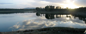
Los Barruecos Natural Monument
Located in the municipality of Malpartida de Cáceres, 11 km from the province’s capital, and set in the middle of the peneplain of Cáceres, this site is characterised by its flat relief and an almost total absence of trees.
Los Barruecos was declared a Nature Monument because of the spectacular nature of its landscape, dominated by large granite balls that stand on the banks of the pools that have created an ideal habitat for wetland fauna, such as mallards, egrets, grey eaglets, otters, newts, as well as white swans, the most characteristic element of the fauna in Los Barruecos, which have found in the cusps of the balls an ideal nesting place. More than fifty nests crown these granite balls, which are mostly located around Las Peñas del Tesoro.
As regards fish species, worthy of note is the tench, whose fishing is an added attraction for the area. With respect to flora, laburnum, broom, foxglove, rushes and buttercups stand out.
Historic district of the city of Cáceres, a World Heritage Site
In 1986, Cáceres was declared a World Heritage Site by the UNESCO and also ranks in third place in terms of monumental sites in Europe.
Although its origin dates back to pre-historic times, Cáceres really began to stand out as a city in the year 34 BC. From that era, an ashlar construction, which forms the oldest gate in the walls, known as Puerta del Río or Arco del Cristo, has been preserved. From that time until it finally formed part of the Kingdom of León, under the reign of Alfonso IX on 23 April 1227, Cáceres suffered periods of decadence caused by a series of Barbarian invasions. The city’s walls were almost completely destroyed until they were restored at a later date as a great fortress under Almohad control.
Cáceres was to reach its greatest splendour in the period of the Catholic Monarchs. From then onwards, numerous palaces and manor houses were built, including the House and Lands of the Ulloa Family, the Palace of Carvajal, the Palaces of the Golfines Family and the so-called Palace of Las Cigüeñas or Stork Palace.
The city walls of Badajoz
The Citadel
Declared a Historic-Artistic Monument in 1931, the Citadel was built on the hills of La Muela, at an altitude of 60 m above the level of the river. Its walled enclosure mostly dates back to the Almohad era, although remains from previous periods and evidence of restoration after Muslim times have been preserved.
The citadel’s enclosure is oval in shape and measures approximately 400 m from north to south and 200 m from east to west. The upper part of the wall and the towers are communicated via a battlemented parapet, or bailey, which is accessed via inner steps.
The most important flanking tower inside the enclosure on account of its size and its characteristics is the "Atalaya" or "Espantaperros".
The Citadel’s other defensive elements are its "sitara" or barbican and the double wall or "coraxa".
The Palmas Gate and Bridge
The Palmas Gate is framed by two crenelated towers with a circular floor plan. They are surrounded by decorative elements, characteristic of the early 16th century, and their vertical faces are covered with renderings imitating ashlars.
Vauban Wall
Built in the second half of the 17th century, it replaced the old mediaeval enclosure. This defensive system, which is called Vauban, as it was masterminded by Sebastián de Preste, Marquis of Vauban, was formed of a successive series of deterring elements, such as forts, bastions, half-bastions, ravelins, lunettes, moats, etc. which made it practically impenetrable.
Multimedia