- Home
- Rural Development
- Nature Trails
- Nature Trails
- Northwest Sector
- Senda del Oso
Senda del Oso Nature Trail. Santa Marina - Ricabo Section
Description
Upstream from the River Ricabo Valley. The charm of the Atlantic forest
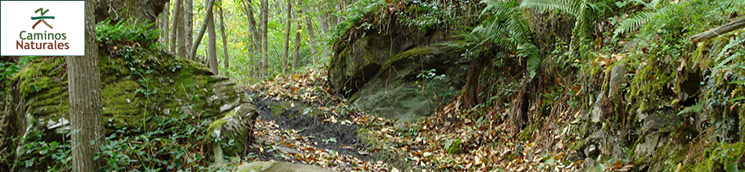
This stretch of the Senda del Oso Trail runs upstream from Ricabo Valley, between Santa Marina de Quirós and Ricabo, in Quirós County, in the south-central Asturias. The path runs along part of the Camino Real de Puerto Ventana, the ancient route between Asturias and León. In autumn, the Atlantic forest is a spectacular feast of colours. Chestnuts, hollies, hazels, oaks and maples escort the visitor throughout the route, as it passes through towns with rich traditional architecture.

Santa Marina - Rodiles
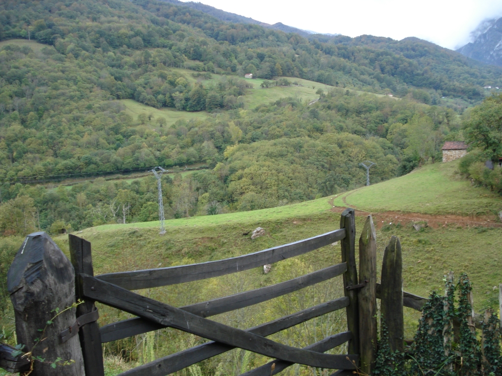
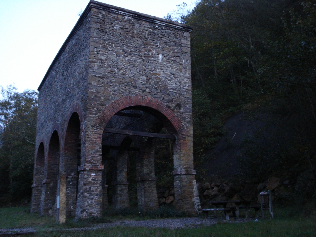
The route starts on the road that leads out of Santa Marina de Quirós towards Lindes, and heads towards a car park located near “El Cribu”, the old coal loading bay from where the mining railroad began its journey through Trubia Valley. The trail begins here, along a track to the right leading up through a lush, dense forest, with a variety of plant species, including chestnut, (Castanea sativa), holly (Ilex aquifolium) and hazel (Corylus avellana). These species serve as indicators of the excellent state of preservation of the Atlantic forest in the region.
Past a site known as "La Llaera", one can get a glimpse of Marina de Quirós through a clearing in the forest. The route soon reaches a steep, 370-metre slope. This is one of the hurdles in this path, in particular for cyclists. Past the hill, as the slope becomes gentler and easier, one can enjoy the rest of the Trail. After a gentle climb, the route reaches a small clearing from where one can see the town of Villamarcel on the opposite side of the valley, surrounded by meadows and hedges. Further on, the path crosses a forest track at a site known as "Los Corros", passing next to a small livestock building and an old, derelict wooden structure, a reminder of the mining activity that once existed here.
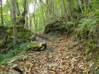
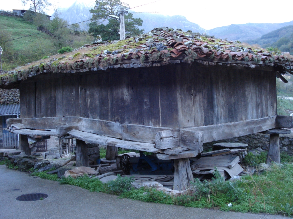
The route, clearly marked at all crossings, continues to venture forth through the dense forest, where ancient trees coexist with younger ones. The route soon arrives at its second hurdle, especially for cyclists. At this point, the path narrows and begins a short but steep descent on uneven terrain to the road from Santa Marina to Ricabo. Caution should be exercised when crossing the road to the opposite side as it carries motorised traffic until Rodiles. The route continues along the access road to the village. Once the route has crossed the River Ricabo ("deep river" in Latin) famous for the quality of its trout, the road arrives at Rodiles, home to an old mill that locals used in the past to grind grain. The town boasts fine examples of traditional architecture, including the 17th century Chapel of Santa Barbara, and a unique "hórreo" in the county, with carved human faces of excellent quality on both ends of the "liño"
The projecting ends are part of the "liños", the upper beams of the "hórreo" fitted on "colondras", vertical wooden boards that shape the box-like structure of the "hórreo" that is closed at the top.
Rodiles - Ronderos
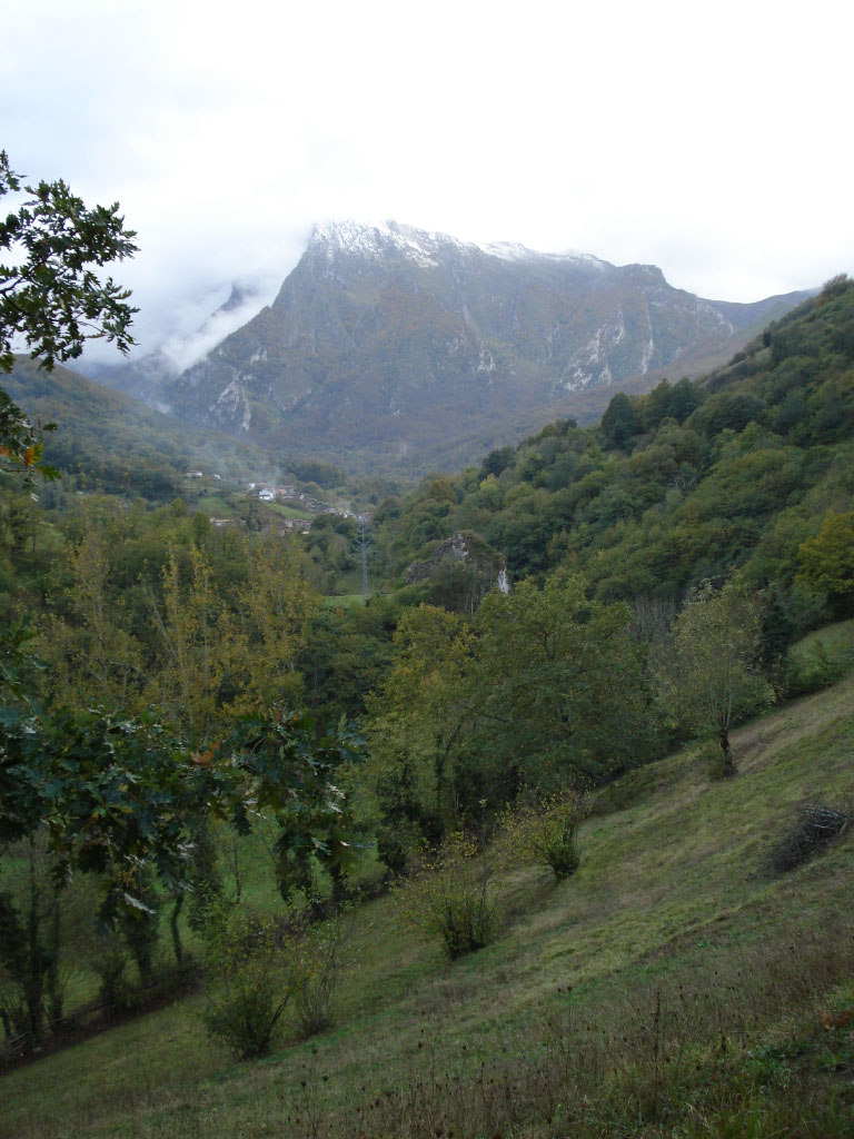
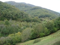
The route now turns left onto the first offshoot road next to a watering trough. A post indicates Km 27 (from Tuñón) on the Nature Trail. The route now begins to climb up the sunny slope of the valley along the former route of the Camino Real. A gentle slope across meadows leads to a right bend, from where one can enjoy wonderful views of Ronderos with the impressive Ubiña Massif in the background. In this stretch, one can see the impact that continued human activity, across the ages, has had on the primitive forests that populated these meadows, of which only a few species remain along the fringes: chestnuts, hazels, Pyrenean oak (Quercus pyrenaica) and hollies, as well as wild roses, brambles, blackthorns (Prunus spinosa) and hawthorns (Crataegus monogyna)
Before reaching the town of Ronderos, one can admire the elegant silhouette of the 19th century Church of San Vicente de Nimbra. A rocky path with a wooden railing leads up a small steep slope to the town. The route traverses along the main street, past the Shrine of Virgen Soberana, to an "hórreo" where it turns right and continues along Camino del Pradal.

Ronderos - Ricabo
Past the village of Ronderos, the route traverses through steep slopes where meadows and scrubland coexist with low-density woodlands and rocky outcrops. The route soon arrives at Ronderos' water tank, next to a watering hole, where one can stock up on water for the rest of the Trail and enjoy the spectacular views of the valley. The path climbs down the Valdecueva Brook Valley, which empties into the pristine waters of the River Ricabo. One can enjoy this little corner of the Trail at a small wooden bridge across the brook. Past the valley, the route comes upon a small stone hut with a tile roof typical of this area. The sound of water and the impressive Ubiña massif accompany the route to the end.
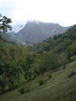
The route continues up and down slopes, flanked again by impressive chestnut and hazel trees, which in autumn tinge the landscape with beautiful colours that are a remarkable sight. These dense forests play host to Asturias’ most representative fauna, including wolves, foxes, badgers, genets, squirrels, wild boars, grouse, and even bears in the highlands, as well as several mustelid and rodent species.
The route winds to the left along a rocky, former wagon road that leads to Cruz Fountain. The descent along this path until the first houses of El Pradal may be unsuited for cycling. From here, the descent continues along easy concrete streets leading to the road to Ricabo, where the Trail ends. This small town is home to the medieval Church of San Bartuelu located near "El Mansu" Recreational Area, which boasts a professional bowling alley where a famous championship takes place in August.
Map
Puntos de Interés
Hidrografía
Municipio
Orografía
Vegetación
Profile
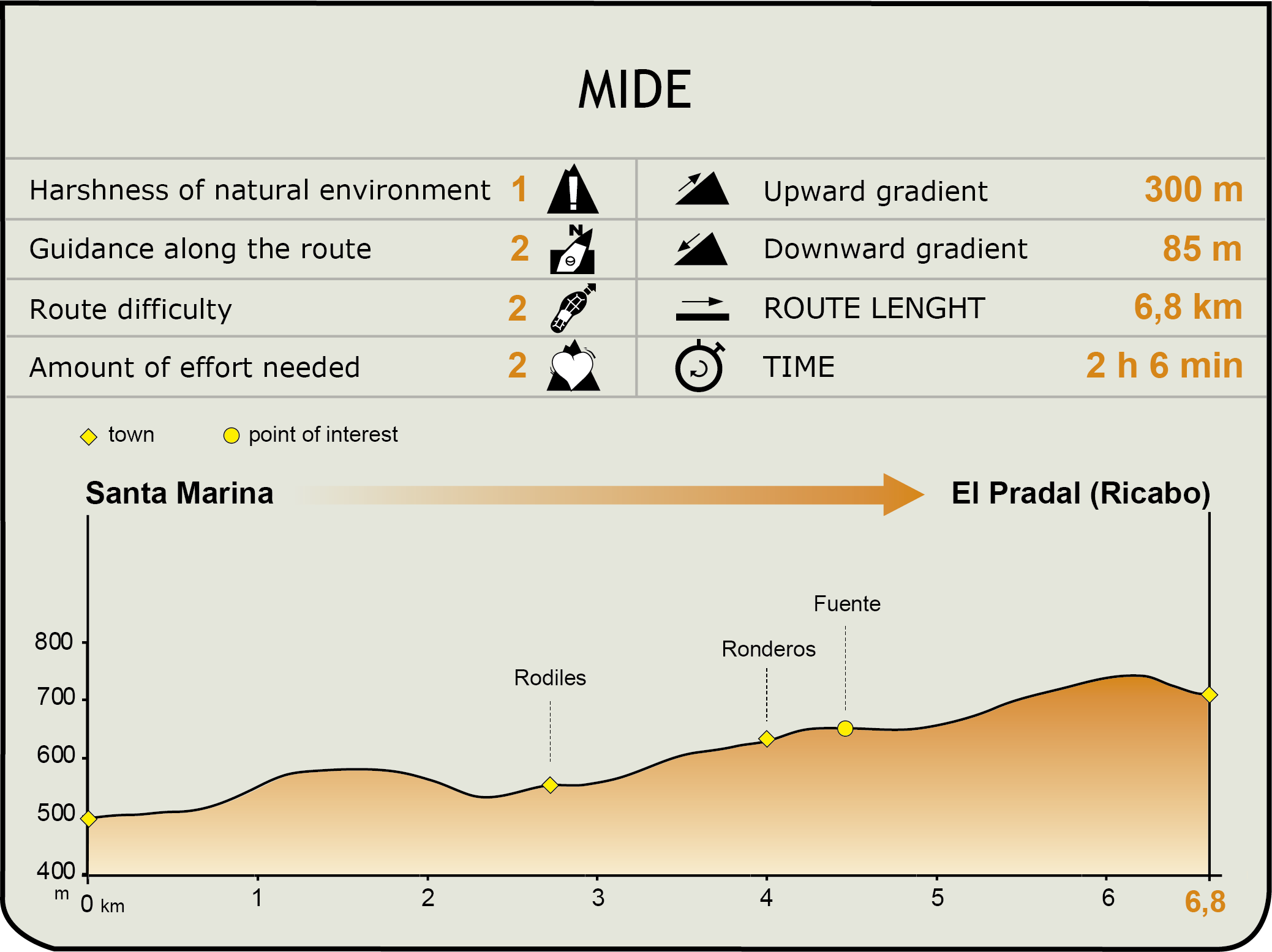
MIDE (Method for the Information of Excursions)
 Harshness of natural environment
- 1. The environment is not risk-free
- 2. There are more than one risk factors
- 3. There are various risk factors
- 4. There are quite a lot of risk factors
- 5. There are many risk factors
 Guidance along the route
- 1. Well defined trails and crossings
- 2. There is a clearly marked trail and signage
- 3. Requires the identification of geographic features and cardinal points
- 4. Requires off-path navigation
- 5. The trail is interrupted by obstacles that have to be gone around
 Route difficulty
- 1. Walking on a flat surface
- 2. Trails with different types of path
- 3. Walking on stepped paths or irregular terrain
- 4. The use of hands or jumping over the terrain is necessary
- 5. The use of hands is required to progress
 Amount of effort needed
- 1. Up to 1 hour of continuous walking
- 2. Between 1 and 3 hours of continuous walking
- 3. Between 3 and 6 hours of continuous walking
- 4. Between 6 and 10 hours of actual walking
- 5. More than 10 hours of continuous walking
Featured
Further information
Las Ubiñas-Mesa Nature Park
Las Ubiñas-Mesa Nature Park, located in the south of Asturias, covers 32,630 hectares spread across the municipalities of Teverga, Quirós and Lena, and limits to the south with the province of León. This mountainous territory is characterised by a terrain with extreme contrasts, with the highest peaks along the border with León. Peña Ubiña is the highest peak, and second largest massif in Asturias. It is second only to Picos de Europa, where the highest peaks rise above 2,400 metres
The diversity and good condition of the vegetation is apparent in the mature forests that cover vast areas. Although beech is the dominant species, there are also oaks and birches. The abundance of grassland and meadows attests to the importance that livestock farming has had over the ages for the local economy.
The rich woodland plays host to the most emblematic Asturian and Cantabrian fauna, including wolves, boars, foxes, genets, roe deer, and deer. This is one of the few places where one can still see the brown bear (Ursus arctos) or the elusive Cantabrian capercaillie (Tetrao urogallus). Bird species of note are the eagle, vulture and peregrine falcon. The otter and Pyrenean desman inhabit the numerous rivers that run through the park, which is proof of the excellent quality of its waters.
One can enjoy the architectural and ethnographic wealth of the towns located within the park, exemplified in their crafts, cuisine and traditions, built up over time and preserved to our days.
The Asturian "hórreo"
The route is dotted with the most built structure that is the unmistakable symbol of Asturian identity: "hórreo". It is usually a square structure with a hip roof, built with removable and transportable pieces of wood, except for the roof, which is built with tiles or thatching.
It stands on pillars (pegoyos) to avoid moisture and prevent rodents and animals from entering the chamber. It can therefore be used to store grain or other food products. It can even be used as a room. The space between the pegoyos (solhorru) is commonly used by the inhabitants of the county to store firewood or work tools. In days of yore, this space was also used to hold neighbourhood meetings and local festivals.
Multimedia