
Stage 9: Langa de Duero - Aranda de Duero
Description
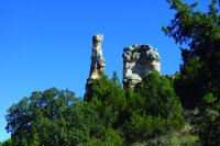
Fairy-tale forests and "chimeneas de hadas"
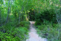
This Stage includes one of the most interesting formations near the Duero: the "chimeneas de hadas" (fairies' chimneys). Narrow paths and riparian forests are a perfect hiding place for elves and gnomes near the River Duero, lending an appealing charm to this Stage.
Aranda de Duero, the large riverside city in the south of Burgos, is the endpoint. This is, without doubt, an excellent opportunity to enjoy the roast spring lamb for which the town is famous. Indeed, it is the headquarters of the Regulatory Council of the Lechazo de Castilla y León Protected Geographical Indication.
The route begins at the edge of Langa de Duero, next to the renaissance bridge and the municipal swimming pool, where a panel displays important information on this Stage. After crossing the bridge, the route turns right and continues along a road for about 550 m. It then turns right again onto a conveniently signposted farm road that is also used by the Camino del Cid Route.
The Trail runs through the River Duero Valley, where the numerous market gardens that have brought fame to the town of Langa coexist with cereal, safflower and sunflower farms, poplar groves and orchards. Nearby slopes have been colonised by Spanish juniper (Juniperus thurifera).
The road comes to a junction and turns right to continue through the River Duero flood plains. The winding green coppices along the banks spread down the slopes to the path leading to several interesting natural rock formations known locally as "chimeneas de hadas”. These strange geological formations were moulded by water. Usually, as the water rushes down the slopes it cuts gullies. Water will erode any rock that it cannot move, sculpting it into unique, fanciful shapes.
Further on, there are mixed forests of English poplar (Populus nigra) and juniper, an interesting combination that is typical of the Burgalese Duero. Active and abandoned agricultural farms alternate in a landscape of roses (Rosa sp.), sage (Salvia sp.), Spanish juniper and poplar.
The route continues to a conveniently signposted junction, where it takes a narrow path that runs parallel to the River Duero. One can feel the quiet and calm of water running through the reeds (Phragmites australis), rushes and small groves, accompanied by the chirping of Chickadees (Parus major), Blue Tits (Parus caeruleus), Eurasian Blackbirds (Turdus merula) and European Goldfinches (Carduelis carduelis). A nearby recreational area provides the opportunity to enjoy this environment.
Riparian forest gives way to repopulation maritime pine (Pinus pinaster), and stone pine (Pinus pinea) when the route reaches the hamlet of El Quemado on the flood plain. As the route approaches a meander, one can see the town of Zuzones perched above the river.
Further on, the path returns to the main road, known as Camino del Quemado, and continues northwest. Near a diversion dam, the route turns onto a path through stone pines, and continues along the River Duero. One can rest at La Vid Rest Area.
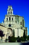
The path returns to the stone wall surrounding the Monastery of Santa María de La Vid, and skirts around it to reach the gate of the monastery and the town of La Vid. The town has a recreational area and a fountain with drinking water. Leaving the town behind, the route takes an underpass on the N-122 road from Valladolid to Soria, and traverses through a meadow before venturing back into a poplar-juniper riparian forest.
The road winds up to Guma, a small town perched atop a hill above the Duero. From the viewpoint, one can see a weir that diverts part of the flow to the Guma Canal used for irrigating the surrounding lands.
At the edge of Guma, the route crosses over the canal and heads southwest through fields of grain, corn and vineyards irrigated with water from the canal. Special attention should be paid to the signs, as the route turns left and right many times.
The path leads back to the River Duero through cornfields. A narrow path appears along the lush riparian forest with a high ecological value. The canopy, which exceeds 20 metres, consists of poplars, silver poplars (Populus alba), willows (Salix sp.), elms (Ulmus sp.), ashes (Fraxinus sp.) and alders (Alnus glutinosa). There is also a rich groundcover of cattails, reeds, rushes and gladioli. A large variety of bird species take refuge in this forest, including Song Thrushes (Turdus philomelos) Common Chiffchaffs (Phylloscopus collybita), Herons (Ardea cinerea), Mallards (Anas platyrhynchos) and Common Coots (Fulica atra).
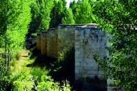
The path arrives at Vadocondes Recreational Area, next to Puenteseco Bridge, with tables where one can rest. The route traverses through Vadocondes along its main street to a bridge on the River Duero. The history of the town, declared a Historical Site in 2008, is inextricably bound up with the river.
Immediately after crossing the bridge, the route turns left along the right bank of the river. It passes under a beautiful iron bridge over the abandoned Valladolid-Ariza railroad. The route takes the left fork at the first junction, and the right fork at the next. The landscape alternates between sunflowers, potatoes and cereals, which grow bountiful in the rich soils of the floodplain.

Following the signs on the Trail, the route reaches La Calabaza Forest on the outskirts of Aranda de Duero; a dense pine-oak Mediterranean forest where the inhabitants of Aranda practice sports and take a stroll.
The route continues west towards the endpoint, skirting around La Calabaza Forest and Guma Canal. However, it passes first next to the Shrine of San Isidro, where a paved road begins.
Here, forests give way to farmlands. The route turns onto the second path that emerges on the left, in the direction of the River Duero.
Once near the river, where the river has carved a large meander, the road turns right, through farms dotted with poplars. However, the landscape changes as the route advances, with market gardens, holiday estates and swimming pools dominating the area. At a fork, the route takes the path to the left surrounded by poplars.
The wide and easy path to Navafrías or Colonia provides quick access to Aranda de Duero via Conchuela Bridge. This Stage ends with a stroll along La Isla Park, situated on the banks of the River Duero.
Profile
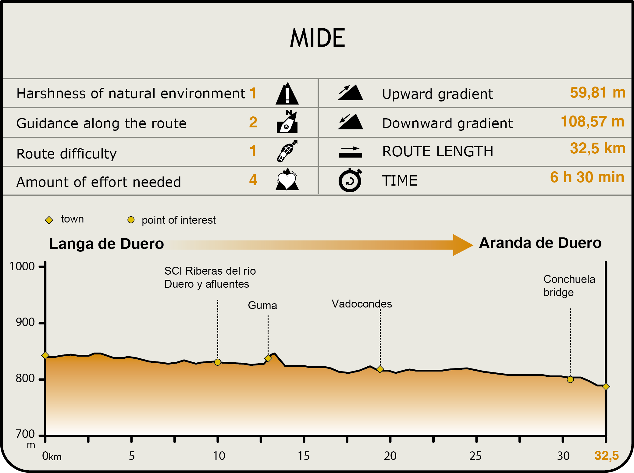
MIDE (Method for the Information of Excursions)
 Harshness of natural environment
- 1. The environment is not risk-free
- 2. There are more than one risk factors
- 3. There are various risk factors
- 4. There are quite a lot of risk factors
- 5. There are many risk factors
 Guidance along the route
- 1. Well defined trails and crossings
- 2. There is a clearly marked trail and signage
- 3. Requires the identification of geographic features and cardinal points
- 4. Requires off-path navigation
- 5. The trail is interrupted by obstacles that have to be gone around
 Route difficulty
- 1. Walking on a flat surface
- 2. Trails with different types of path
- 3. Walking on stepped paths or irregular terrain
- 4. The use of hands or jumping over the terrain is necessary
- 5. The use of hands is required to progress
 Amount of effort needed
- 1. Up to 1 hour of continuous walking
- 2. Between 1 and 3 hours of continuous walking
- 3. Between 3 and 6 hours of continuous walking
- 4. Between 6 and 10 hours of actual walking
- 5. More than 10 hours of continuous walking
Featured
Further information
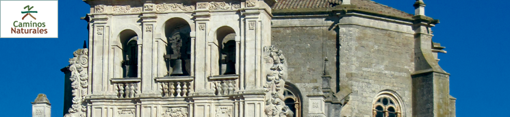
Monastery of Santa María de la Vid
The monastery, declared a Property of Cultural Interest, was one of the most important Castilian abbeys during the Middle Ages, with a Norbertine and Augustinian feel to it.
The first Norbertine abbots arrived circa 1140, after the pacification and withdrawal of Muslims "beyond the Duero". They abandoned the monastery in 1835 when the site was secularised. Augustinian monks settled permanently in the monastery in 1865, and continue to this day.
The monastery boasts a library with books of great interest, including manuscripts and incunabula.
The collection includes royal, ecclesiastical and private manuscripts from the fourteenth to the eighteenth century. There are also literary, scientific, and historic manuscripts from the twelfth to the eighteenth century; as well as books of sermons, historical notes and documents in oriental languages, mainly from the nineteenth century.
Worthy of note is a Koran manuscript on parchment from the year 528 of the Hegira (1134 of the Christian era), written in gold and in blue, red, black and green ink.
The library also holds 22 identified and catalogued incunabula, of which 8 were printed before 1490, and 6 are the only known copies in Spanish libraries.
Multimedia


