
Stage 6: Andaluz - Gormaz
Description
Pinewoods and sandbanks in the heart of the province
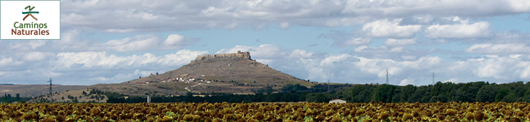
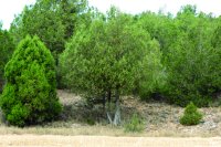
Much of the Stage runs through maritime pine forests in the heart of the province of Soria, stretching all the way from the riparian terraces and sandbanks to the north of the River Duero. In the final stretch, the Stage runs along the river until the town of Gormaz, at the base of the impressive Caliphal fortress, atop a high hill from where it dominates the entire region.
Starting from the bridge on the River Andaluz, in the namesake town, the route heads south along the SO-102, toward a gallery of trees that line the river.
The route turns right along a forest track known as Camino de Andaluz, then reaches the Roman bridge over the River Duero, well worth a visit. Hundreds of Spanish junipers (Juniperus thurifera) blanket the steep, limestone cliffs to the right, whose slopes ease down to the fertile flood plains of the River Duero used for agriculture. The wood of Spanish junipers, locally known as "enebros", are very fragrant and rotproof. It is traditionally used to make quality furniture.
The landscape is interspersed with maritime or cluster pinewoods (Pinus pinaster), whose trunks show huge resin tapping scars.
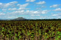
The Trail continues until Canturrial Refuge, a small stone cottage with tables and benches arranged around a stone fireplace. It is undoubtedly a good place to rest and recover. The typical landscape of this area consists of fields of cereal dotted with sunflower fields next to pinewoods. The route heads through woodland towards the road to Tajuelo. Here it turns left and continues for about 300 metres, running parallel to the road along a sandy firewall. It then turns to the right again onto a path leading into a dense pinewood.
A few metres further on, there is a recreational area with many tables, barbecues, a fountain and a refuge. Another opportunity to stop and rest.
The route continues through the pinewood, similar to others in the area, which grow on alluvial sands from river runoff. This type of soil severely limits the flora to species that can survive on sandy soils, including the rockrose (Cistus ladanifer).

Some pine trees have a round ball of pine needles, called "witch's broom", caused by a fungus that results in the abnormal growth of cells, resulting in the overgrowth of the acicular system.
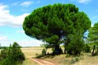
A huge stone pine (Pinus pinea), well worth contemplating, stands at the edge of the pinewood, next to the road and near the edge of the farmlands.
The route arrives near at Bayubas de Abajo, where it follows the road until it reaches the village. The route traverses through the town and leaves through the southern Stage, following the River Bayubas. The landscape here is a true mosaic of agricultural lands, farmed poplar (Populus sp.) and forests in which Spanish junipers, maritime pines and rockrose coexist.
After crossing the River Bayubas, continuing along it, the route reaches a fork, where it heads along the right branch. Not far away, in a small pine stand, is Canterillo Recreational Area, equipped with barbecues, tables and a fountain. Spanish junipers and rockrose slowly take over the landscape.
The route reaches the SO-116, crosses to the opposite side with caution. It continues along Roza de la Aguilera forest track that heads towards the small La Hoz Gorge, flanked by rocky, limestone cliffs on which only the Spanish junipers can survive.
Derelict livestock pens and folds, where herds were kept at night, can be seen on the opposite side; silent witnesses of the downfall of traditional farming practices.
The route traverses through a maritime pine forest, in which one can see the holes made by the Great Spotted Woodpecker in some dried-out tree for foraging or nesting.
The route turns 90º to the right at a farmed poplar plantation, heading back into the pinewood along the road to Berlangas de Duero. It traverses through a low-density pinewood, with large trees, covered with rockrose thickets. The largest and best trees, known as "parent trees", have been left to repopulate an area that has been logged for timber.
Further on, the route turns sharply to the left, and traverses through an area with few pine trees. The GR-86 trail that shared this stretch of route continues straight ahead.
The road winds through various pine forests that were tapped for resin in the past. For a short while, the route runs parallel to a disused railroad overgrown with vegetation. Further on, it crosses the tracks to leave the pinewood behind and venture into farmland.
The last stretch is graced with the beautiful silhouette of the Caliphal Fortress of Gormaz on the horizon, located on a large promontory from where it dominates the surroundings. The fortress can be used to calculate the remaining distance of this Stage.
One can easily encounter roe deer (Capreolus capreolus) and wild boars (Sus scrofa), which seek shelter and food in the forest.
The route traverses through fields to meet an old acquaintance, the River Duero, whose banks, populated with a variety of trees, shrubs and aquatic species, have been designated as a Site of Community Importance and Special Area of Conservation within the Natura 2000 network. The route turns right and follows the river to Gormaz.
In the middle of a meander, the Trail drifts away from the river, turns right and ventures into irrigated and rain-fed farmland until it reaches a few farms. Here, it turns left and continues through a Spanish juniper forest and farmland, with the fortress straight ahead. The route continues to Fuentes Grandes Recreational Area, located next to the River Duero, with many tables and benches on grass. This is a wonderful to stop and watch the river flow, and drink the spring water that comes from the ground.
Barely 1.5 kilometres away is the small town of Gormaz, located under the watchful eye of the ruins of the Caliphal fortress, and the endpoint of this Stage.
Sites of interest
Profile
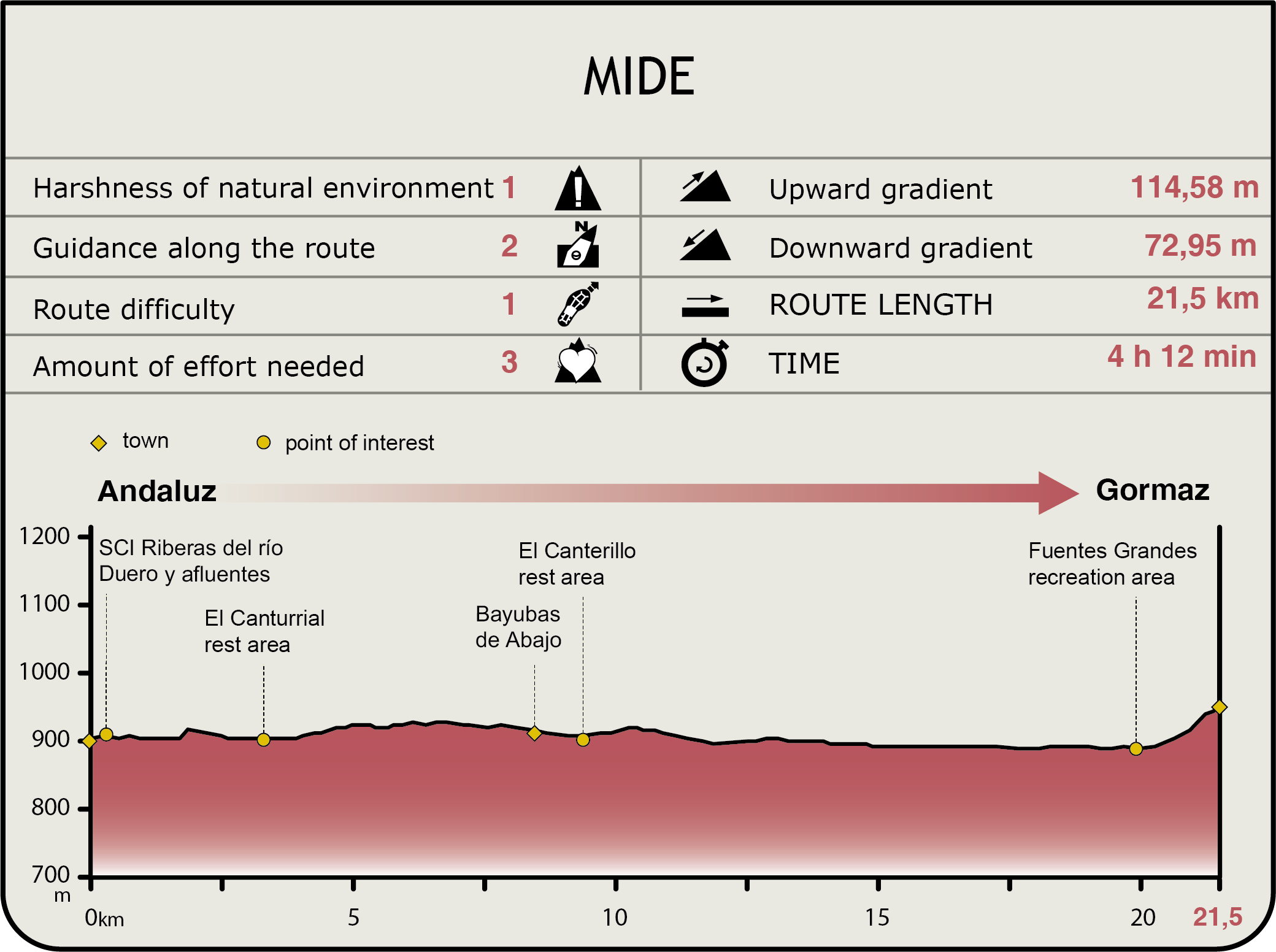
MIDE (Method for the Information of Excursions)
 Harshness of natural environment
- 1. The environment is not risk-free
- 2. There are more than one risk factors
- 3. There are various risk factors
- 4. There are quite a lot of risk factors
- 5. There are many risk factors
 Guidance along the route
- 1. Well defined trails and crossings
- 2. There is a clearly marked trail and signage
- 3. Requires the identification of geographic features and cardinal points
- 4. Requires off-path navigation
- 5. The trail is interrupted by obstacles that have to be gone around
 Route difficulty
- 1. Walking on a flat surface
- 2. Trails with different types of path
- 3. Walking on stepped paths or irregular terrain
- 4. The use of hands or jumping over the terrain is necessary
- 5. The use of hands is required to progress
 Amount of effort needed
- 1. Up to 1 hour of continuous walking
- 2. Between 1 and 3 hours of continuous walking
- 3. Between 3 and 6 hours of continuous walking
- 4. Between 6 and 10 hours of actual walking
- 5. More than 10 hours of continuous walking
Featured
Further information
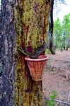
Traditional use of the resin
Since time immemorial, humans have been using resin or "miera", as it is called once it flows out of the tree. It is derived from the sap of coniferous trees, primarily maritime pine. Its use is even mentioned in the Bible.
Resin was used, inter alia, for caulking (sealing) ships or animal skins to hold liquids, such as wineskins. White spirit (turpentine) and rosin are distillation from pine resin. It is used in perfumery, ointments, glues and, even, in chewing gum.
It was originally extracted from stumps or wood chips through flameless combustion, a process similar to the production of charcoal in "pegueras" or resin ovens. However, starting in the mid-nineteenth century, resin was extracted directly from the live tree, "bleeding" the tree by making cuts in the bark without causing its death. The sap was gathered in containers similar to flower pots. Indeed, they can still be seen in our mountains used as a decorative element in many houses.
Resin was a very important source of income and labour in the 1960s and 1970s. It ceased to be profitable with the advent of imported products and new artificial chemical products. Nowadays, it merely has testimonial or ethnographic value.
Resin extraction has marked the landscape of much of the region, as maritime pine was a preferred source. The trunks of the trees show the characteristics wounds with the borders still forming scar tissue.0
Caliphal fortress of Gormaz
The caliphal fortress of Gormaz is situated on an elongated hill, a natural watchtower that can be seen from afar on the Sorian plain. The fortress, declared a National Monument in 1931, played a key role in the reconquest of the Duero border.
The fortress was built between 956 and 966 on the site of an earlier castle.
In the tenth century, the Muslim troops launched from here many attacks or "razias" on the Christian lands north of the Duero. The commanding presence posed a constant threat to the Christian population who tried to settle in the area.
The fortress is almost entirely built with cut ashlars. It consists of two distinct areas separated by a moat: the fortress and the walled compound.
A 10-metre tall wall surrounds the compound’s perimeter (1.2 kilometres). Most of the 26 towers are rectangular, save those on the wall which are solid to the first floor. The troops, stables and storage rooms were based here. It also had a large, stone cistern carved into the rock.
In 975, Count Garci Fernandez, allied with Sancho de Pamplona and Ramiro III of León, was unable to take the castle after a long siege, suffering a humiliating defeat when attacked by Galib's army who came to the rescue. Although he finally conquered Gormaz between 978 and 981, Almanzor recovered it again in 983. It was not until 1060 when Ferdinand I, Count of Castile, definitely conquered the fortress for the Christians.
Gormaz and the Church of San Miguel Arcángel
A stroll through the streets and surroundings of the small town of Gormaz reveals a few small treasures.
The Cid Campeador most likely crossed several times this ten arch Roman bridge on the River Duero. A pillory, symbol of justice and civil jurisdiction, represented the village's independence from the Lord and his Lordship.
On the edge of the town stands the Romanesque shrine of San Miguel, declared a Property of Cultural Interest, which dates back to the late 11th or early 12th century. The paintings on the vault and walls of the apse, which depict a battle between two armies of knights, is worthy of note. The shrine was also home to a baptismal font, a prism-shaped, quadrangular limestone with a cross-shaped, concave cavity, which can now be found at the parish church.
A stone plaque commemorating the construction of the caliphal fortress was found, with the inscription: In the name of God the Merciful. God bless Muhammad, the Seal of the Prophets. He sent the servant of God, al-Hakam al-Mustansir Billah, Commander of the Faithful, may Allah prolongs its duration!
Multimedia


