
Stage 37: Aldeadávila de la Ribera - Mieza
Description
In the bowels of Arribes
A narrow, winding path leads down from the peneplain to the bottom of Arribes, offering stunning views of the river surrounded by a Mediterranean forest with high biodiversity. This is followed by a tough but rewarding ascent, with countless natural viewpoints in each bend.
The route leaves Aldeadávila de la Ribera along a farm road enclosed by stone walls and Pyrenean oaks (Quercus pyrenaica). Attention should be paid to the signs, as there are several crossroads and forks. If one looks closely, one can see Naverrabea Pond to the left.
A few metres before reaching the access road to Aldeadávila Reservoir's power substation and Fraile Viewpoint (with spectacular views of the power infrastructure and impressive granite cliffs on the River Duero), the route turns left onto Camino del Rao de los Pajeros that emerges from the opposite side of the road.
After crossing the road, a well-kept track that runs through open terrain populated with yellow brooms (Cytisus scoparius) and grasslands, always enclosed by stone walls. Granite flatrock outcrops can also be seen frequently.
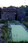
The Trail reaches a bird observatory with a washhouse, known as Fuente del Mendo. If one gazes up into the sky, one can see the majestic Griffon Vultures (Gyps fulvus), with their large wing span, gliding away into the vastness of the landscape.
Further on, the path ends in an olive grove. From here, the route continues along a steep, winding, and sometimes rocky track that leads down to the bottom of Arribes.
The descent down the west slope offers a sampling of the vegetation that thrives in this milder, peneplain microclimate, including all kinds of Mediterranean species such as olive trees on terraces, holm oaks (Quercus ilex), Scotch brooms, turpentine trees (Pistacia terebinthus), strawberry tree (Arbutus unedo), etc.
Hackberries (Celtis australis), a small tree that grows on rocky slopes, ravines, and steep, dry and sunny banks near waterways, also abound in this area.
The trail opens at times, revealing the steep valleys of Ropinal Brook (along which the road to the village of Aldeadávila runs) and the River Duero, into which it empties. The path eventually reaches the paved road at the Km 8 milestone, at the edge of the village of Salto de Aldeadávila.
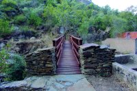
The route runs down the main street of the village towards the south edge, where it continues down a flight of stairs that lead to a charming wooden bridge on Ropinal Creek.
From here, the peneplain on which Mieza sits is about 3.5 kilometres away. This stretch runs mostly on a narrow, upward path that climbs from 250 m to 650 m above the sea level. The climb is challenging, but the surrounding landscape and views are well worth the effort.
Vegetation grows abundantly on the north and west face, owing to the thermal conditions and greater humidity of the narrow canyon through which the River Duero runs. The rich variety is unheard of in other parts of the Duero Nature Trail through Arribes. Holm oaks, gall oaks (Quercus faginea), strawberry trees, turpentine trees, Montpellier maples (Acer monspessulanum), hackberries, willows (Salix sp.), brooms, white-leaved rockrose (Cistus albidus), wild asparagus (Asparagus acutifolius), common ivy (Hedera helix), etc., salute the opposite bank in Portugal, with its perfectly manicured, terraced olive groves and orchards. The peaceful, wide Duero looks on in the shadow of the impressive, vertical rock walls of Canada do Cozo in Portugal.
During the climb, one can take advantage of the clearings in the bends to view the landscape, take some pictures, rest and recover.
The last stretch climbs up the ravine carved out by the River Santa Marina, which the route crosses. Past the last viewpoint on the River Duero and the valley, the path widens and is less steep. One can now see private farmsteads enclosed by stone walls in which vineyards, orchards and holm oaks grow.
Further on, the path joins a track from where an offshoot road to the right leads to the spectacular La Code Viewpoint. The route continues to the left towards Mieza, the endpoint of this Stage, which lies less than 1 kilometre away.
Sites of interest
Profile
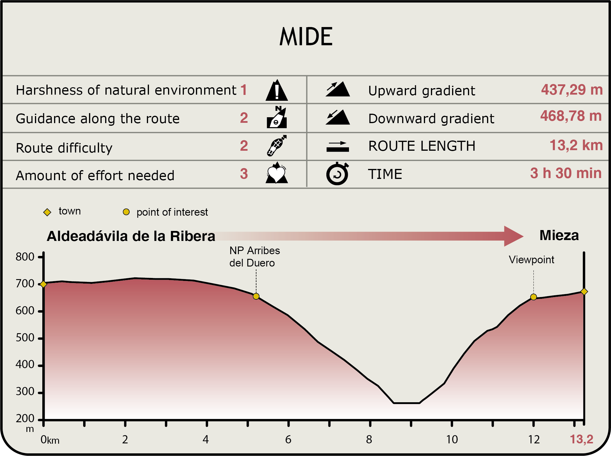
MIDE (Method for the Information of Excursions)
 Harshness of natural environment
- 1. The environment is not risk-free
- 2. There are more than one risk factors
- 3. There are various risk factors
- 4. There are quite a lot of risk factors
- 5. There are many risk factors
 Guidance along the route
- 1. Well defined trails and crossings
- 2. There is a clearly marked trail and signage
- 3. Requires the identification of geographic features and cardinal points
- 4. Requires off-path navigation
- 5. The trail is interrupted by obstacles that have to be gone around
 Route difficulty
- 1. Walking on a flat surface
- 2. Trails with different types of path
- 3. Walking on stepped paths or irregular terrain
- 4. The use of hands or jumping over the terrain is necessary
- 5. The use of hands is required to progress
 Amount of effort needed
- 1. Up to 1 hour of continuous walking
- 2. Between 1 and 3 hours of continuous walking
- 3. Between 3 and 6 hours of continuous walking
- 4. Between 6 and 10 hours of actual walking
- 5. More than 10 hours of continuous walking
Featured
Further information
Aldeadávila Reservoir
This reservoir is considered one of the most emblematic works of engineering both nationally and globally. It was built between 1958 and 1962, when Spain began to open to the world during the Franco regime.
Aldeadávila Reservoir, and its power plant, is the largest producer of electricity in Europe. All the technologies, experiences and lessons learned in hydraulic engineering up to the 1950s were combined to build this structure.
It was built at a particularly timely moment given the energy needs of the country and innovations in construction techniques. At that time, Spain saw progressive economic development. It began to build large thermal power plants to meet basic market demand. Hydroelectric power was intended only to meet peak demand. This co-ordinated production called for power plants with a high generating capacity and fewer operating hours. Aldeadávila was built with this vision in mind.
The use of innovative means and construction techniques allowed faster construction, interrupted only by flooding along the River Duero.
The village of Salto de Aldeadávila, where the operating and maintenance staff lived, was built in a less steep area near the construction site. The inn and the chapel were built on the ruins of the Franciscan convent of La Verde, where, as legend has it, St. Francis of Assisi stayed during his historic pilgrimage to Santiago de Compostela.
Multimedia

