
Stage 12: Peñafiel - Quintanilla de Onésimo
Description

In the heart of the Douro
The path runs along the calm, still waters of the River Douro as it traverses a gallery forest. Occasionally, it ventures onto the floodplain to regale the traveller with the characteristic landscape of Ribera del Duero, covered with vineyards and stone pine forests, and home to some of the best wineries.
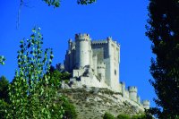
Peñafiel and its impressive, majestic castle take centre stage from the beginning of this Stage that ventures into the heart of Ribera del Duero.
The Stage begins at a park along the River Duratón in the centre of Peñafiel. A small path along the left bank leads to several interesting facilities now in disuse, such as mills, dams and a steel railroad bridge, that were part of the county's history of industrialisation and modernisation.
Further on, the route reaches the peaceful confluence of the rivers Douro and Duratón, two rivers that have left their mark upstream, as they opened their way through the territory. The River Duratón Gorge, in the province of Segovia, is a spectacular ravine where the river has cut a deep c through the terrain, creating a remarkable landscape.
The route continues along a narrow path wedged between the River Douro and San Pablo pine forest, dominated by stone pines (Pinus pinea). The route ventures ahead, alternating between riparian forest and pinewoods, and occasionally both. The absence of crossroads means that one can relax and enjoy the sound of the river and its inhabitants. In the company of the calm waters of the River Douro, the route advances one step at a time.
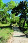
Pesquera de Duero sits on the bank of a wide meander, where a large walkway provides access to this town with a long-standing wine tradition. The path begins to climb gradually up to the floodplain, leaving behind the confined valley of the River Douro. Pine forests give way to an area dominated by rain-fed farmlands and wastelands.
Soon after, a sign indicates an offshoot road to Pintia Archaeological Site, with a Stage open to the public. The site, which covers an area of about 125 ha, contains rich evidence about Vaccean, Roman and Visigoth cultures.
The path climbs down again to the river. There is a mini hydroelectric power plant fuelled by water from the diversion dam. Stone pine trees and riparian forest yet again surround the Trail. The path climbs up and down several times until it reaches the floodplain, with spectacular views of both the river and the stone pine forests, which find their optimum ecological balance in this setting. The steep embankments in this area prevent the route from continuing along the river. The path winds up and down the slopes, sometimes steep but short, which requires some effort. Cyclist may have walk this part of the route and exercise particular caution.

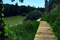
Near Quintanilla de Arriba, the Nature Trail crosses to the opposite bank via a footbridge with sweeping views of the river. It then continues to climb down along the bank.
From here, one can take a 2-kilometre alternative route that is conveniently signposted. Several wooden walkways and stairs lead the traveller deep into the river to reach this town, where, in the summer, one can bathe in its river beach or contact an active tourism enterprise to book a trip on a canoe.
To forge ahead without visiting Quintanilla de Arriba, one must cross the River Douro at the detour sign mentioned above and continue along the opposite bank.
The path heads along the River Douro through poplars, ashes and willows, although holm oaks (Quercus ilex) and stone pines can also be seen frequently. The landscape near the river is dominated by riparian vegetation; however, as the path climbs to the alluvial terrace, pines, oaks, vineyards and crops take centre stage.
The Cistercian Monastery of Santa María de Valbuena, built in the 12th century, appears shortly after a hydroelectric power plant. The first monks came from the French abbey of Berdoues. It is currently the headquarters of the Fundación de las Edades del Hombre, which seeks to disseminate and promote the sacred art of the Autonomous Community of Castile and Leon across Spain.
The route continues along riverside groves, with some fishing spots and benches to rest while watching the river’s soothing flow. The next town is Valbuena de Duero, where one can fish, bathe or row a boat along the Trail, or rest at Parque de la Isla on the outskirts.
This last stretch of the Stage meanders along the River Douro. Charming little paths, wooden bridges over small streams and meandering walkways in the riparian forest lead to the bridge on the river, built between the sixteenth and seventeenth centuries. This bridge links the riverside towns of Olivares de Duero and Quintanilla de Onésimo, where this Stage ends.
Profile
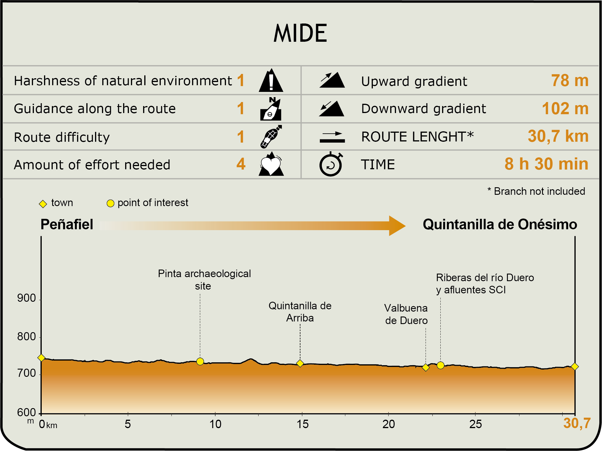
MIDE (Method for the Information of Excursions)
 Harshness of natural environment
- 1. The environment is not risk-free
- 2. There are more than one risk factors
- 3. There are various risk factors
- 4. There are quite a lot of risk factors
- 5. There are many risk factors
 Guidance along the route
- 1. Well defined trails and crossings
- 2. There is a clearly marked trail and signage
- 3. Requires the identification of geographic features and cardinal points
- 4. Requires off-path navigation
- 5. The trail is interrupted by obstacles that have to be gone around
 Route difficulty
- 1. Walking on a flat surface
- 2. Trails with different types of path
- 3. Walking on stepped paths or irregular terrain
- 4. The use of hands or jumping over the terrain is necessary
- 5. The use of hands is required to progress
 Amount of effort needed
- 1. Up to 1 hour of continuous walking
- 2. Between 1 and 3 hours of continuous walking
- 3. Between 3 and 6 hours of continuous walking
- 4. Between 6 and 10 hours of actual walking
- 5. More than 10 hours of continuous walking
Featured
Further information
Peñafiel Castle
Peñafiel Castle dates back to the 10th century. It is first mentioned in a document from 943. Although Almanzor, the famous Moorish military leader, conquered the castle in 983, it was reconquered by the Castilian count Sancho García in 1013. It appears that he was responsible for the change of name from Peña Falcón to Peñafiel (Penna Fidele in Latin), when he made that famous remark: "Henceforth, this rock shall be the most loyal rock in Castile".
The castle, which has two compounds, has a very narrow and elongated layout (about 35 m wide and 210 m long) that ends in an acute angle on the north side. The oldest part of the building is the smooth, outer wall dating from the 11th century. The only gate to the castle is on the eastern side, flanked by two circular towers topped by a machicolation, of which only the corbels remain.
A second wall delimits the inner enclosure. It consists of 28 crenelated cubes equidistantly placed along the rampart that can be accessed via a "chemin de ronde".
In the inner enclosure stands a 34-metre, rectangular keep divided into three vaulted storeys. There are two large courtyards on either side of the tower. The accommodations for soldiers and servants, as well as the stables, were located to the south, and the storage rooms and water cistern were situated to the north. The cistern that supplied water to the castle and the underground chambers still exist near the tower. The keep was probably accessed by a drawbridge.
Pintia Archaeological Site
Pintia is a site rich in heritage with more than one millennia of history. However, the legacy of the Vaccean society, between the 4th century B.C. and 1st century A.D., is the most important.
Although few archaeological remains are visible, the site has been excavated and renovated in recent years. The most important areas within the archaeological site are the city of Las Quintanas, the necropolis of Las Ruedas, the "ustrinum" or crematorium of Los Cenizales, a possible sanctuary, and the crafts quarter of Carralaceña with a residential area, necropolis and pottery workshops.
The Vacceans were Celtic people from northern Europe, and the first inhabitants of the Douro and Pisuerga valleys. They settled in several waves in a territory that comprised much of Valladolid and Palencia, as well as parts of Zamora, Segovia, Avila and Burgos.
Although they founded self-governing cities, including Pallantia (current Palencia) and Pintia, they continued to maintain strong ties with sister cities in the area. They even helped the Aravacans in Numancia during the Roman siege of the city. In revenge, the Romans laid siege and destroyed Pintia, obliterating the Vaccean culture, religion and language.
It has been discovered that the city of Las Quintanas was ravaged by fire. The Visigoths subsequently built a necropolis over the remains of the ancient Roman-Vaccean city.
Other findings include rich tombs of warriors in the necropolis of Las Ruedas, and the crafts quarters of Carralaceña, built across the river owing to the risk of fire posed by the pottery kilns when they were operating at full capacity.
Multimedia


