
Stage 1: Fuente del Duero - Vinuesa
Description
A mountain river through Sierra de Urbión
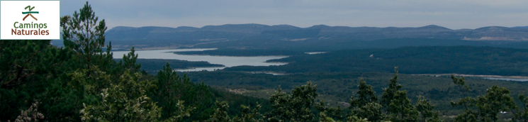
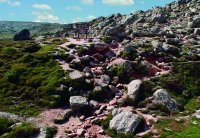
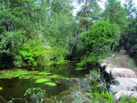
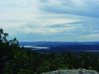
The headwaters of the River Duero lie barely a few metres from the summit of the Urbión (2,228 m) within the Laguna Negra y Circos Glaciares de Urbión Natural Park. The first section of the river flows through an alpine mountain landscape, characterised by pastures and rocky cliffs, which soon give way to vast forests of magnificent Scots pine that blanket the slopes of Sierra de Urbión. In this first section, the River Duero is a mountain river, with crystal clear waters, and a rocky bed, a perfect place for trout to find food and shelter.
The Senda del Duero Nature Trail begins in Picos de Urbión, from where a steep descent leads to Duruelo de la Sierra, along the same as the Sendero Ibero-Soriano (GR-86). This upper section of the route, almost until Duruelo de la Sierra, is very unsuited for cycling.
The road traverses through Peñas Blancas, Fuente del Berro, Castroviejo, La Chorla and Las Huertas. The Trail parts ways with the GR-86 before Las Huertas ends, making a U-turn to the left along a dirt track leading to the River Duero, which it crosses on a bridge. It then continues along the left bank of the river, traversing through La Mata, until it finally reaches the streets of Duruelo de la Sierra.
Along the way, one can easily encounter deer (Cervus elaphus) and roe deer (Capreolus capreolus), and, with a little luck, one can even find highly sought wild mushrooms such as chanterelles (Lactarius deliciosus) and porcinis (Boletus spp.).
Most villages have signs indicating the route, although, in most cases, it is a simple metal plate attached to the façade of houses. The trail traverses through the town of Duruelo de la Sierra, leaving aside the church and necropolis of San Miguel Arcángel. It leaves the town along the bridge on the river Triguera.
Leaving the CL-117 behind, the trail crosses a wood and wire gate via a pedestrian crossing.
Soon after crossing the fence, at a concrete shed, the Nature Trail parts way with the GR-86 at a properly marked crossing. The Trail turns left and ventures into a Scot's pine forest (Pinus sylvestris) or "pino albar", as it is called locally.
The route continues down a small slope via a few wooden steps, then continues through meadows covered by a mature Scot's pine forest, leaving the River Duero to the left.
Further on, the route crosses a rudimentary bridge, and continues along the right bank of the river, leaving the old Santo Domingo Bridge to the left. The Trail runs along this bank, through a place called Las Tozas, until it reaches Arrieros Bridge, a large masonry bridge, where the route crosses to the opposite bank.
Past several recreational areas (Pozo de San Millan, Los Apretaderos and Arenilla), the path continues towards a semi-paved road, leaving to the left a medieval bridge known as Puente de Soria. It continues straight ahead along a dirt track called Camino de la Morciguilla.
Chaffinches (Fringilla coelebs), Chickadees (Parus major) and Blue Tits (Parus caeruleus) are a feast for eye and ear during this open part of the pine forest. At one point, the paved road disappears and an offshoot road, Ranchal de la Machorra, appears to the right, from where one can see another road further to the right. A few meters ahead, the path appears to vanish, but in fact continues along steep road used to drag timber. Once in the summit of Salegar del Calvo, there is a small track to the left, leading to a wider forest track, where the Nature Trails merge again with Sendero Ibero-Soriano GR-86.
The path continues a few hundred metres through El Hornillo and Peñas Rubias, with magnificent views of Sierra de Urbión. Pinewoods disappear, giving way to a wild Pyrenean oak (Quercus pyrenaica) forest, or "melojo" as it is called locally.
At the next crossroads, the route continues to the left, gradually climbing up to Pico del Águila, where a forest fire watchtower stands. The Trail continues downhill along a narrow path, between Pyrenean and holm oaks (Quercus ilex), and huge blocks of aggregates. The winding road continues along this path, past a forest track that the trail ignores.
The descent is steep and fast. The Nature Trail reaches the Shrine of Santo Cristo, just a few metres from the village of Molinos de Duero. The river appears flanked by willows (Salix sp.), poplars (Populus sp.) and hawthorns (Crataegus monogyna.
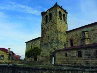
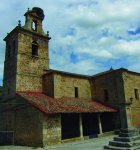
Along a paved road, flanked by a Via Crucis, the route ventures into Molinos de Duero. The parish church of San Martin de Tours, patron saint of the village, welcomes the visitors. The hamlet has several emblematic buildings such as the Real Posada de la Mesta and 17th century mansions of carters.
The path leaves Molinos de Duero to the east, crossing under a huge stone bridge over the Duero, and continues along the Roman road leading to Vinuesa, with a concrete bridge to the left. The Trail is now a stone slab and cobblestone road, where one can even see the ruts made by the carts, and the plaques with the names of the builders. This section is unsuited for cycling.
The River Duero accompanies the route throughout this stretch. The river gradually widens, merging into the tail of the Cuerda del Pozo Reservoir. After a couple of kilometres along the Roman road, flanked by pine trees and willows in an area that may be flooded in winter, the route reaches the shrine of San Mateo and a Roman bridge. About 500 metres further on, the first section of the Duero Nature Trail ends in the south of Vinuesa.
Sites of interest
Profile
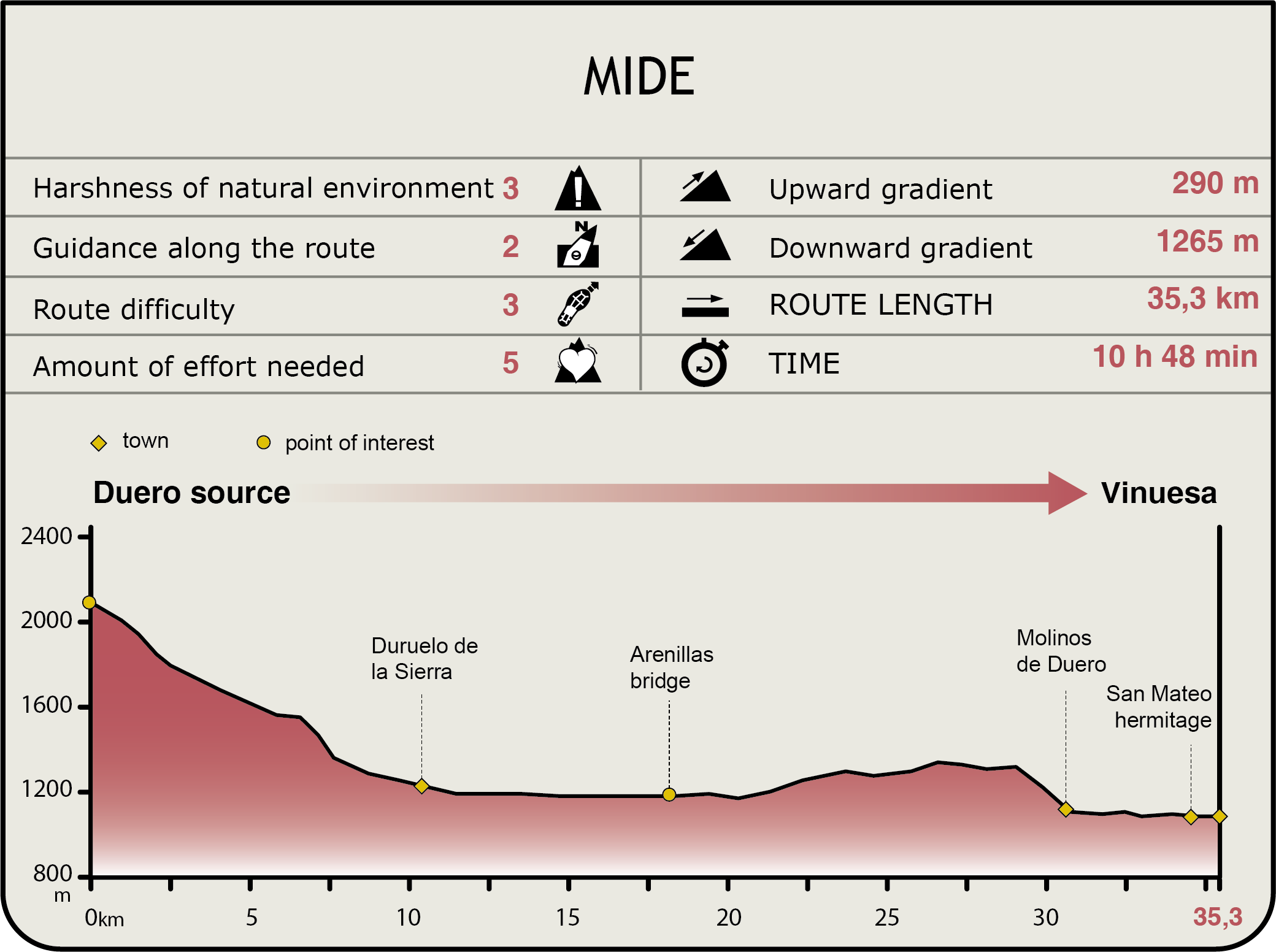
MIDE (Method for the Information of Excursions)
 Harshness of natural environment
- 1. The environment is not risk-free
- 2. There are more than one risk factors
- 3. There are various risk factors
- 4. There are quite a lot of risk factors
- 5. There are many risk factors
 Guidance along the route
- 1. Well defined trails and crossings
- 2. There is a clearly marked trail and signage
- 3. Requires the identification of geographic features and cardinal points
- 4. Requires off-path navigation
- 5. The trail is interrupted by obstacles that have to be gone around
 Route difficulty
- 1. Walking on a flat surface
- 2. Trails with different types of path
- 3. Walking on stepped paths or irregular terrain
- 4. The use of hands or jumping over the terrain is necessary
- 5. The use of hands is required to progress
 Amount of effort needed
- 1. Up to 1 hour of continuous walking
- 2. Between 1 and 3 hours of continuous walking
- 3. Between 3 and 6 hours of continuous walking
- 4. Between 6 and 10 hours of actual walking
- 5. More than 10 hours of continuous walking
Featured
Further information
Pine forest dwellers
Goshawks (Accipiter gentilis) forage for mammals and birds in the pine forests during the day, whilst at night, the Tawny Owl (Strix aluco) hunts for rodents and insects.
Insects, which feed on dead trees and leaf litter, abound in the forest. They are eaten, in turn, by birds, weasels (Mustela nivalis) and ermines (Stoat), that hide in the undergrowth. Many small bird species feed on fruits and seeds. Chickadees, titmice and finches build their nests in small caves and tree cavities.
The largest animals in these pinewoods are deer, roe deer and wild boars (Sus scrofa). Although they are difficult to see, one can easily find marks and footprints that indicate their presence.
Carters and Carts
For years, the trade in and transport of wool, salt, coal, oil, wine and metals drove the need for muleteers. Given this situation, the Catholic Monarchs founded the Real Cabaña de Carreteros, granting the muleteers certain privileges and franchises (grazing rights in communal pastures, logging to repair carts, etc.).
Many towns in Pinares County focused on building roads and providing care to draught animals (oxen). Molinos de Duero was the provincial hub of this traffic. At one point, it had more than 2,700 oxen for 872 carts: the largest population of draught animals in Spain.
The wealth accumulated during those years can be seen in the stonework architecture of Pinares County: stately homes, palaces, mansions from the sixteenth and eighteenth centuries with large entrance halls to load and unload goods. Most of these houses, many of which are emblazoned, have an arched doorway, wooden balconies that run across the façade, wrought iron windows, wide eaves and beautiful courtyards.
Multimedia


