- Home
- Rural Development
- Nature Trails
- Nature Trails
- Northeast Sector
- Sort y la Vall d'Àssua
Sort i La Val D´Assua Nature Trail
Description
Between the valley and the mountains of Lleida
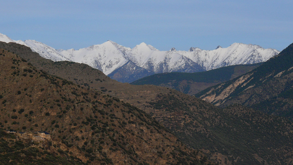
Far from the noise of the large cities and the most populated areas, the Sort and la Vall d’Àssua Nature Trail takes us into the corners of the Lleida region of El Pallars Sobirà, a mountainous area strewn with picturesque villages that are home to unique churches and mediaeval castles, which survive in the middle of the countryside and are spread across the different valleys that all lead to the River Noguera Pallaresa, the main channel of communication.
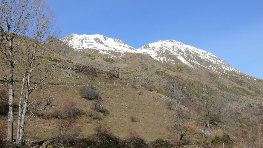
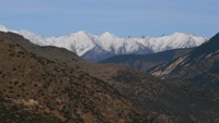
El Pallars Sobirà, in the province of Lleida, is the region with the most protected spaces in Catalonia, spread around the Aigüestortes i Estany de Sant Maurici National Park and the Alt Pirineu Natural Park. It is here that you can find the largest lake in the Pyrenees, that of Certascan, and the highest peak in Catalonia, the Pica d’Estats.
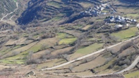
The 15 municipalities this mountainous region is divided into are comprised of 135 towns strewn around the different valleys that all lead to the River Noguera Pallaresa. The Sort and la Vall d’Àssua Nature Trail will enable you to visit these small towns, characterised by their oldest buildings, especially their churches, some Romanesque and others with a marked Lombard influence, fruit of their isolation, where the slender development of many of their bell towers stands out.
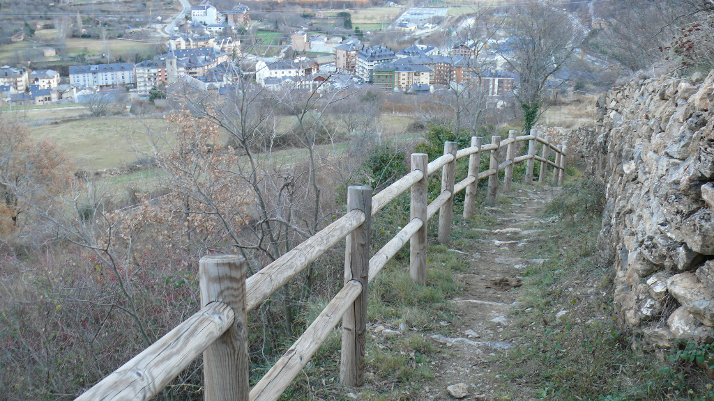
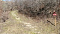
The route will take you away from roads and lead you across old communication channels, such as bridleways, which will allow you to enjoy pastoral rural landscapes and will draw you close to the traditions of the area, where the use of livestock and subsistence farming characterized the lives of their inhabitants for many centuries.
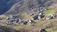
Via the Nature Trail, you will enter the nooks and crannies of El Batlliu de Sort and the Vall d’Àssua, in an area characterised by its low population density. From the path, you will be able to visit the little villages of Olp, Castellviny, Pujalt and Bressui, in El Batlliu de Sort, and those of Altron, Bernui, Llessui, Sauri and Sorre, in the Vall d’Àssua.
The Sort and Vall d’Àssua Nature Trail forms part of a series of routes renovated around a main path that is divided into six sections, between the towns of Sort, Olp, Altron, Sauri, Llessui, Les Bordes de Llessui and el Pas de Mainera. There are twelve secondary routes connected to this main path.
Part of the Trail passes through three stages of an important theme route called El Pas del Temps (The Passing of Time), which can be found in Pallars Sobirà and Pallars Jussà. This tour begins in La Pobla de Segur and ends in Isil, following the axis of the River Noguera Pallaresa through an exceptional landscape, which stretches from the Pre-Pyrenees to the foot of the Pyrenees. The section of the Nature Trail between Altron and Olp and the section of its diversion between Olp and Pujalt can be found within this important route.
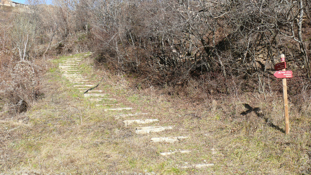
From Sort to Olp
The route begins in the noble town of Sort, the capital of Pallars Sobirà. Worthy of note in its city centre is the castle of Los Condes de Pallars, located in the upper part, close to the paths of Sort leading to the Vall d’Àssua and the towns of Batlliu de Sort (the old definition of towns that depended on a larger municipality). In Sort, you will also find the prison-museum of the Camino de la Libertad, which houses the testimonies of World War II fugitives who passed through this part of the Pyrenees and also the Church of Sant Feliu. The main path leaves from the extreme southwest of the town of Sort, following a tarmacked road that leads to the upper part of the ruins of the castle.
Just before you enter the castle, a track emerges on your right that ascends between meadows in a north-westerly direction. A little later, you leave this track, which you will cross again later, and continue along a bridleway flanked by high walls that merges further on with a tarmacked section, which you will continue along northwards for a little more than 300 m. The route leaves the road and, on the left, you will take the bridleway once again.
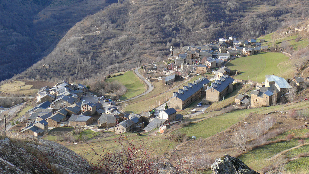
Continuing in a north/north-westerly direction, the Trail merges, in its final section, with a stretch of track that takes you to Olp, where you can visit the large and beautiful, recently-restored parish church of La Madre de Dios de la Purificación or de la Candelera, and the ruins of the Church of San Pedro. A little more than a kilometre away, on a hill overlooking the town, you will also discover the small Chapel of San José, from where you will have magnificent views of the valley.
In this first section of the main path, you can choose to take some secondary alternatives that link up with the Nature Trail. Some of these diversions begin in the vicinity of the River Noguera Pallaresa and others in the area surrounding the ruins of Sort castle. One of them is the route that leads to the town of Bressui. Returning to the road that accesses the remains of the castle, in the vicinity of the first bend, a track emerges which, a few metres further on, changes into a bridleway heading in a south/south-westerly direction. Among scrubland bushes and luxuriant, small grassland-covered patches, you will reach the houses of Bressui. To go back, you continue along a bridleway in the direction of the terraced meadows located to the north of the town of Bressui and you continue across a steep hillside where the path becomes narrower. In this way, you will access the lower section of the path between Pujalt and Sort, which heads along a bridleway, and which you will take downwards in a easterly direction, covering the meadows located to the west of Sort, until you reach the vicinity of its castle once again.
Another of the secondary routes that you can take from the town of Sort emerges on the left bank of the road bridge over the River Noguera Pallaresa. From here, along the left bank of the river, you climb up to the upper part of the flood protection mound that descends southwards. From this height, you will have an excellent view of the River Noguera Pallaresa and of the meadows and poplar groves located in the bottom of the valley. After covering the mound, the Trail continues along a track very close to the level of the course of the river which, in this section, is very wide because it is not channelled. In this way, you will reach the River Cantó and follow its course upwards very close to the right bank, without crossing it, as far as the base of a holm-oak covered hillside.
In this setting, the route converges with a traditional lane between Tornafort and Sort, which you will follow in a northerly direction around the base of the holm-oak grove. This traditional lane finally merges with a track that accesses estates and, subsequently, with a main tarmacked track that crosses the industrial estate of Sort and which will take you back to your starting-point.
From the left bank of the road bridge, some 30 m away, you can also take a track that emerges on your left at the rear of some buildings, and which leads to the town of Rialp. On following this track, you will come to a fork, where you take the left-hand branch. As you go on your way, the route gradually heads in a northerly direction and leads to the bank area of the river. Over a long section, you will walk very close to its thick hardwood linear forest. A little further on, the path narrows and ascends in order to avoid some cuttings by crossing an open holm-oak forest. The route then descends, crossing, in its lower part, a fenced estate, until it reaches a tarmacked lane that accesses the estate from the road. By descending along this tarmacked track, you will return to the river and cross over it via a bridge. Later on, you will cross the road and, at the rear of a petrol station, you will continue along a wide path that will take you to the bottom of the valley, among meadows and hillsides, as far as Rialp.
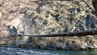
The town of Rialp was a walled village of mediaeval origin with a castle which, in its heyday, was the most important in the Vall d’Àssua. This castle, which was initially a watch tower for the castle of Surp, is currently in a state of ruin. At one end of the village stands the Church of La Madre de Dios de Valldeflors and its original centre still preserves the Gothic series of arches of the entrance to the torrent of San Antonio, where the riverside porticoed royal route passed. A pedestrian walkway over the River Noguera Pallaresa affords access to different routes on the other slope.
From Sort, you can also access, via another secondary diversion, one of the corners most frequently visited by the inhabitants of the town, the Fuente de la Matraca. In order to get here, you follow a road accessing a residential area which also emerges from the left bank of the bridge over the River Noguera Pallaresa. This lane is located between two roads. You cross the residential area and continue along a path that enters a forest mass and which leads you to an area of small plots, where you will come to the fountain.
In order to return to Sort, you can choose from two alternatives. One of them is to retrace your steps and take a track that descends towards the valley to then take another that will take you back to your starting-point. The second alternative is also a track that descends down to the valley and affords access to the main, partly tarmacked road, and which accesses the industrial estate.
Finally, following the leg of the Nature Trail from Sort to Olp, you can access a tarmacked road you take on your left to reach the area of La Borda de Botja. At this point, a bridleway emerges which will lead you across a terraced landscape among meadows and hardwood-tree lined hedges as far as Castellviny. Once in Castellviny, you head towards the church and to its road access, from where you will continue along a steep path that corresponds to an old by-path, which will enable you to link up with the bridleway between Pujalt and Olp.
From Olp to Altrón
The second stage of the main path runs between Olp and the town of Altron. From Olp, you head northwards along the road to Pujalt, but a little more than 100 m from the town, you take a track on your right, which goes in a northerly direction straight away and changes into a bridleway that makes its way among meadows, pasturelands and tree-lined hedges. On roughly reaching the gradient change, a path emerges on the right which takes you to the Chapel of Sant Josep, an interesting viewpoint over the valley.
From this diversion, the bridleway heads in a north-westerly direction among hay meadows that subsequently turn into pastures and hillside areas, where marcescent oaks (Quercus sp.), poplars (Populus alba), ashes (Fraxinus sp.) and common hazel trees (Corylus avellana) can be seen. You cross the road and continue along a track that leads to the Chapel of Mare de Déu de Montserrat.
Continue along this track which soon turns westwards and leads you to the town of Altron, where you can visit unique buildings such as the Church of San Sadurní or Sant Serni, the Chapel of Montserrat or of El Roser and the Subirà ancestral home which, during the 18th century was one of the most powerful houses of the Vall d’Àssua.
One of the secondary diversions that begins in Olp will take you to Pujalt. The Trail leaves from the lower district of the town of Olp, from the church square itself, from where you head southwards to take a bridleway that emerges on your right after crossing a ravine via the road to Castellviny. This is a bridleway that crosses meadows and hillsides covered with a mass of mixed hardwood trees. On arriving at the gradient change, for a few metres the route coincides with the road from Olp to Pujalt. In this setting, and with views of the town of Pujalt, there are benches and an information panel on butterflies.
From here as far as Pujalt, the route continues along a bridleway. In Pujalt, you can visit a butterfly interpretation centre. From the extreme southeast of Pujalt, you can also return to Sort. At the beginning, the path winds a good deal owing to the slope of the land, but it straightens out as you descend. In its upper half, the path crosses dense hardwood masses and marcescent oaks, poplars, ashes, willows (Salix sp.), maples (Acer sp.) and sorbs (Sorbus sp.) can be seen. The lower half of the route, practically just after linking up to a path accessing Bressui, is a bridleway. The path then crosses a track that accesses the hay meadows located to the west of Sort. Before reaching your destination, the Trail merges with the track that begins in the vicinity of the castle and the upper part of Sort’s church.
From Altrón to Sauri
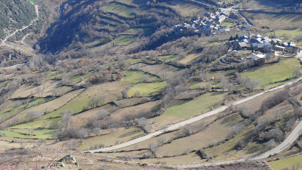
The third section of the main path links the towns of Altron and Sauri together. From the road entrance to Altron, the route begins along a track that emerges straight ahead in a southerly direction. A few metres further on, this track disappears at a fork and you take the right-hand path that goes in a south-westerly direction. The route offers excellent views of the area surrounding Altron and Sorre and continues on its way over a hillside crossing small meadows, on the flattest land, and thick hazel-nut and mixed hardwood forests on the sloped land. In the hardwood forests, you will find common aspen (Populus tremula), ashes, marcescent oaks, black poplars (Populus nigra), birches (Betula sp.), sorbs, maples and walnut trees (Juglans regia).
The Trail becomes narrower in the stretches that make their way across the forest and becomes wider when it crosses meadows. You continue along a downward by-path that crosses the meadows as far as the course of the River Boïgues. Then, you alternatively cross two ravine walkways and climb up a path to Sauri.
DFrom Altron, one of the diversions from the main path you can take leads to the Fuente de Libeto. This is a small circular route that runs along a track located in front of the road entrance to the centre of Altron. You climb a track that soon disappears and which forks into two paths. In order to ascend, you follow one of the two and you return via the other. They are paths that access the meadows located on a terrace that are higher than those surrounding the town.
From Sauri to Llessui
The fourth stage of the main route runs between Sauri and Llessui. The Trail begins in the upper part of Sauri, next to the Church of San Víctor, whose style is in keeping with that of the surrounding area. On the other bank of the river, the house and old site of Menauri also stands out along with the ruins of the ancient Romanesque church of San Esteban.
Next to Sauri’s church, a concrete track emerges that subsequently turns into a bridleway. This path crosses and follows the road to Llessui in two small stretches, before reaching this town from its southern end. In the original centre of Llesui, you will find the church of San Pere, which boasts the unusual feature of having its entrance under the bell tower, and the Romanesque church of San Julián in the district located to the east.
From Sauri, you can also take another secondary diversion that leads you through Bernui to Sorre. This route begins at the lowest houses in the town of Sauri along a track heading eastwards. If you keep on in this direction and then turn north-eastwards, through pastures, you will reach Bernui, where worthy of note is the Romanesque church of Santa María, in whose interior there is a polychrome wood carving of La Madre de Dios.
You cross Bernui in an easterly direction to take a bridleway that makes its way below the level of the main meadows in this town. In this way, you will access a stretch of some 250 m along the road towards Sorre, until you take, once again, the bridleway that winds down to the beginning in a north-easterly direction. You enter Sorre to the west of the town centre next to a recreational area. You cross the road and you are now in Sorre, where the small Church of San Esteban, of Romanesque origin, but subsequently altered, also stands out.
To the south of Sorre, you will find the Chapel of San Antonio and, on the way to Caregue, the small Chapel of Santa Ana, which you can access along a bridleway that leaves from the northern end of Sorre and which makes its way among hay and grazing meadows in a north/north-easterly direction. From the Chapel of Santa Ana, you will enjoy spectacular views of the valley.
Taking Bernui as your starting point, you can take another diversion to join the Nature Trail between Altron and Sauri. In order to do this, you leave from the eastern end of Bernui and, some 100 metres from the town centre, you begin to zigzag down a path across the southern hillside located at the foot of the town, until you reach the River Boïgues. You then cross the river and continue on a path that runs along the right-side riverbank until you reach some meadows. After crossing these meadows, the route continues among thick hazel-nut trees and meadows until you reach a track that finally converges with the Nature Trail.
Another secondary route linked to the main path is one that runs between Llessui, Sorre and Altron. This path leaves from the group of houses in Llesui located to the east along a track that links up to the main path that ascends towards the valley, and which you follow in a downward direction to your right. On reaching the road, you take a bridleway that descends between pastures and scrubland hillsides. On your descent, you will also cross a pastoral landscape of meadows with tree-lined hedges. Before entering Sorre, the path crosses the road twice.
In order to go down to Altron from Sorre, you follow a track that subsequently converges with an old bridleway. This path is crossed further ahead by the track, but you must continue in a north-easterly direction as far as the vicinity of the River San Antoni, where you continue in a southerly direction to access the meadow area to the east of Altron and, from there, you climb up to a group of houses.
From Llessui to Les Bordes de Llessui
The fifth section of the main route of the Sort and the Vall d’Àssua Nature Trail runs between Llessui and Les Bordes de Llessui. The route leaves from the vicinity of the Church of Llessui and continues in a north-easterly direction across urbanised areas until it reaches a group of buildings located in the highest part of the town. At this point a bridleway emerges, with beautiful cobbled sections, which ascends across meadows as far as the viewpoint of Sant Jaume, where you will have excellent views of the valley. Following the path, and when the gradient changes, you cross some areas of hillside pastures. Then, you cross the main track that accesses the valley and continue along a bridleway, whose boundaries are blurred in this section, until you reach a secondary track which runs along the valley embedded in a level that is lower than the main track. You continue on your way along the secondary track, with beautiful views of the valley and of the rocky hillsides of the left slope of the course of the River Berasti-Rialbo, and enter the area of Les Bordes directly.
From Les Bordes de Llessui to the Pas de Mainera
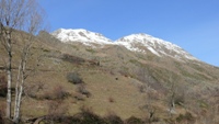
Finally, the Nature Trail runs along a last section that links Les Bordes de Llessui to el Pas de Mainera. The route leaves between the two main buildings and ascends to the beginning along a short section of fenced path until it reaches a hut in the upper part. From there, for a stretch, you follow an old track that finally turns into a path once again. As you climb and cross several ravines, the path becomes narrower and, at the end, it turns into a track with some less well-defined sections. The Trail takes you along the left bank of the River Berasti as far as the Pas de Mainera. From the Trail, you will enjoy spectacular views of this high-mountain valley which you will climb through hillside pastures, a mass of hazel-nut trees, patches of mountain juniper berry and the spectacular high course of the River Berasti, with its rapids and small waterfalls.
Profile
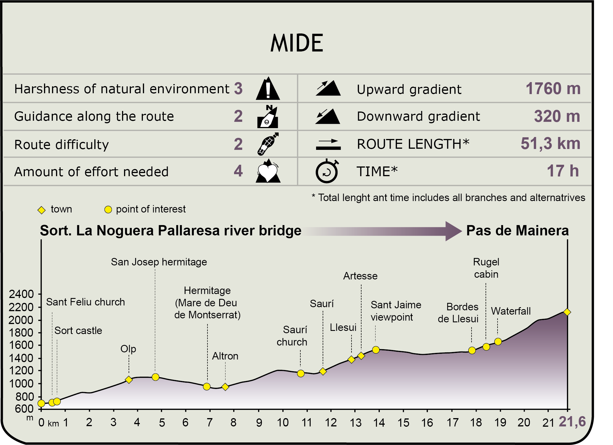
MIDE (Method for the Information of Excursions)
 Harshness of natural environment
- 1. The environment is not risk-free
- 2. There are more than one risk factors
- 3. There are various risk factors
- 4. There are quite a lot of risk factors
- 5. There are many risk factors
 Guidance along the route
- 1. Well defined trails and crossings
- 2. There is a clearly marked trail and signage
- 3. Requires the identification of geographic features and cardinal points
- 4. Requires off-path navigation
- 5. The trail is interrupted by obstacles that have to be gone around
 Route difficulty
- 1. Walking on a flat surface
- 2. Trails with different types of path
- 3. Walking on stepped paths or irregular terrain
- 4. The use of hands or jumping over the terrain is necessary
- 5. The use of hands is required to progress
 Amount of effort needed
- 1. Up to 1 hour of continuous walking
- 2. Between 1 and 3 hours of continuous walking
- 3. Between 3 and 6 hours of continuous walking
- 4. Between 6 and 10 hours of actual walking
- 5. More than 10 hours of continuous walking
Featured
Further information
The Alto Pirineo Natural Park
The town of Rialp affords access to an important protected space, namely the Natural Park of L’Alt Pirineu, the most extensive in Catalonia, and where the highest altitudes of Catalan territory are located. It has enormous natural value, with areas of great geological interest and a rich variety of flora and fauna which is especially unique and interesting, relating to environments ranging from the mountain to the Alpine of the southern slope of the Central Pyrenees. It features an extensive network of itineraries, routes and paths for accessing its towns and valleys.
Aigüestortes I Estany de Sant Maurici National Park
Located to the north of the province of Lleida, in the Central Pyrenees, Aigüestortes i Estany de Sant Maurici National Park was created on 21 October 1955. It was the fifth National Park in Spain and the second in the Pyrenees, after Ordesa National Park.
Along the Sort and the Vall d’Àssua Nature Trail, you access the fringe area of Aigüestortes, a protected space that is characterised by a high-mountain landscape with an impressive relief and extremely rich fauna and vegetation. The more than 200 lakes or estanys and the characteristic high-mountain meanders (las aigüestortes) that descend the hillsides are the great protagonists of the Park, in conjunction with the impressive crags of “Els Encantats”.
In conjunction with pine, birch and beech trees, in Aigüestortes i Estany de Sant Maurici National Park worthy of note is the presence of the fir tree, so scarce in Spain, which is at its most beautiful in the area known as the Mata de València.
Multimedia