- Home
- Rural Development
- Nature Trails
- Nature Trails
- Northeast Sector
- Somontano de Barbastro
Stage 3: Las Almunias de Rodellar-Salto de Bierge
Description
Route to El Salto de Bierge alongside the river Alcanadre
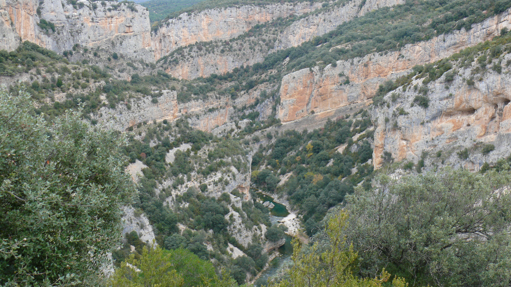
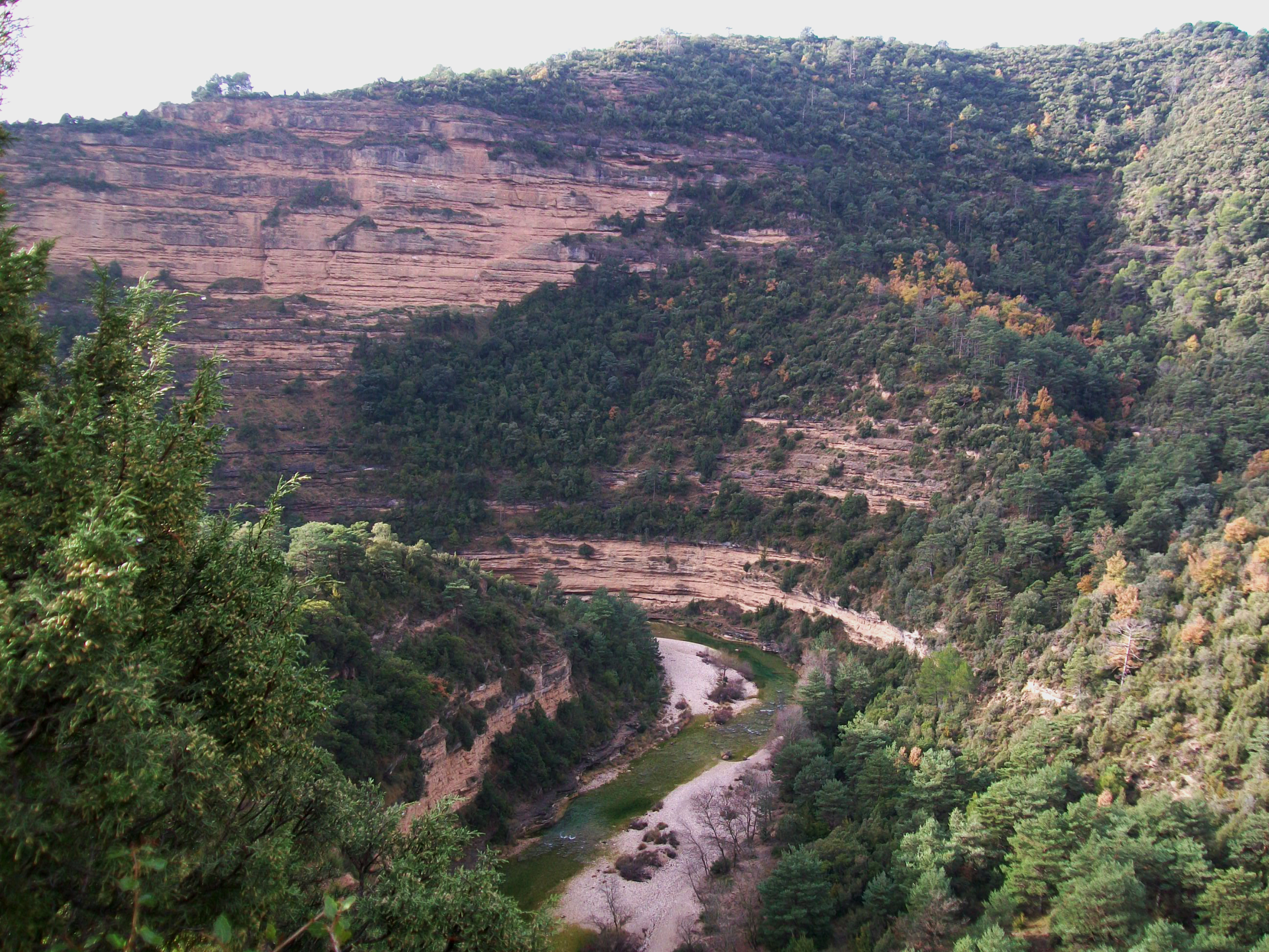
The river Alcanadre is an almost constant companion in this last stage of the Nature Route. The river wastes no time in heading off between limestone rock faces towards the final point at El Salto de Bierge, an old weir that was used for a mill and to supply a small hydroelectric station.
The Route passes around Las Almunias del Rodellar without actually entering the village and then joins up with an asphalted road that gently slopes down to the river Alcanadre between pastures and cropland.
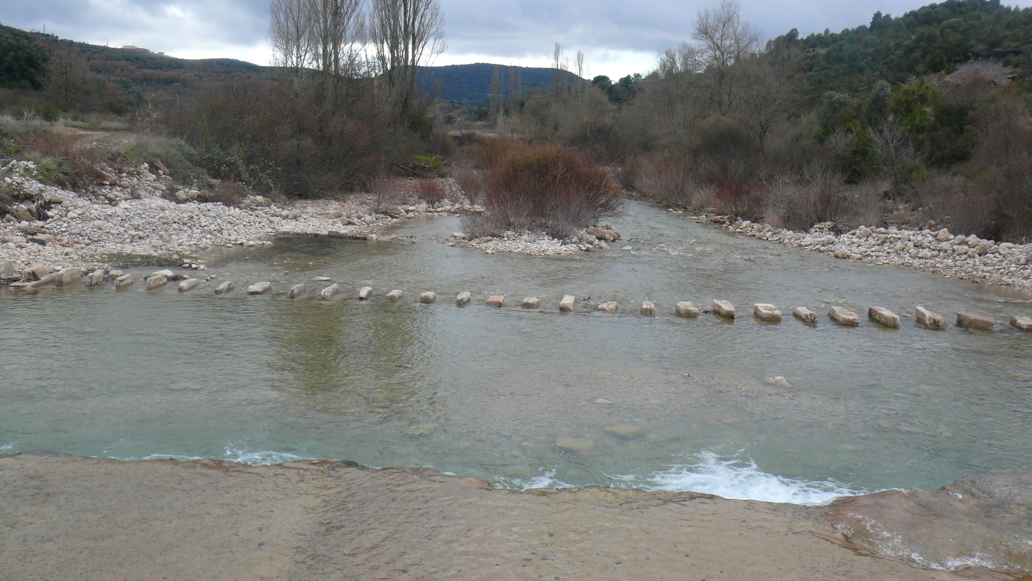
Then, to your left just before you cross the bridge over the river you can see an example of how people crossed watercourses in the Sierra de Guara: the Pasaderas de Pedruel. It consists of a set of square-shaped stepping stones embedded in the river bed at a distance of a one and a half metres from each other.
After you take one way or the other to cross the river, the route continues along the road for another 200 m, and then splits off towards Pedruel along an old path that takes you to the centre of Pedruel; a small village that forms part of the municipality of Bierge. Not many of the houses are occupied now, but they are well conserved.
Before you continue on the route, and if you have time, it's worth walking upriver for a kilometre to see the medieval bridge of Pedruel, a simple but beautiful one arched stone bridge, halfway between Pedruel and Rodellar.
From Pedruel, the route continues along the path that starts at the church in the southern part of the village and heads off for several kilometres in the same direction as the river Alcanadre at the bottom of the valley between the sierras of Arangol and Balced. Along the way you'll see how the bottom of the valley gets narrower and steep slopes covered with vegetation take the place of farmland.
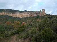
Then you'll start to make out the entrance to the canyon of the Alcanadre, in an area called section La Peonera. The route crosses the ravines and streams that flow into the river, while on each side you'll find diversions that take you to other interesting local sites that are not on the Nature Route. One is the diversion to the hermitage of La Trinidad, on a high point that looks out over the river, near the Fuente Güega and a reservoir, or the two routes to the so-called Castillo de Naya, a rocky enclave with impressive views over the valley.
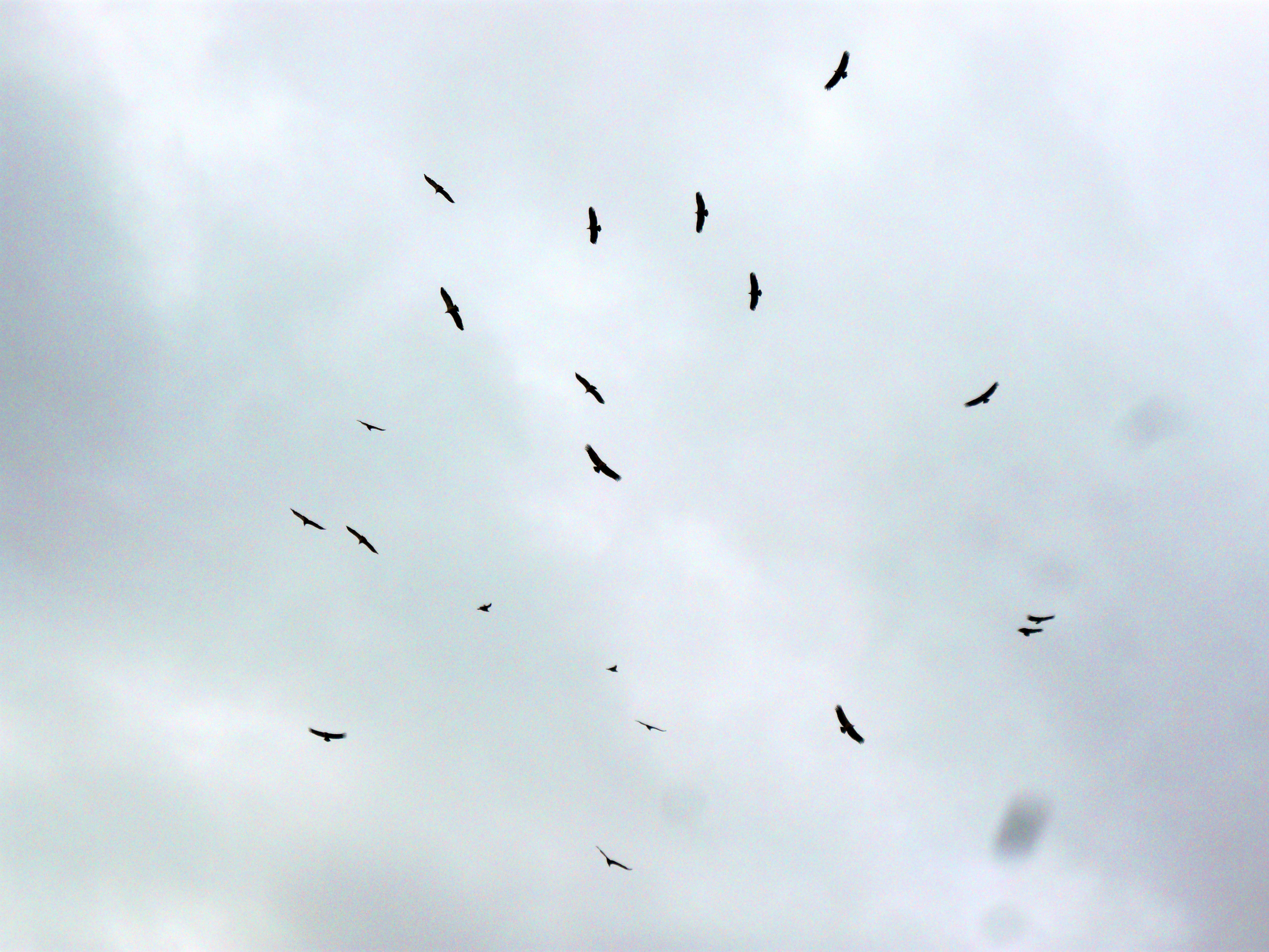
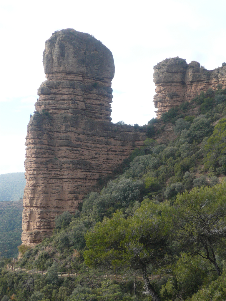
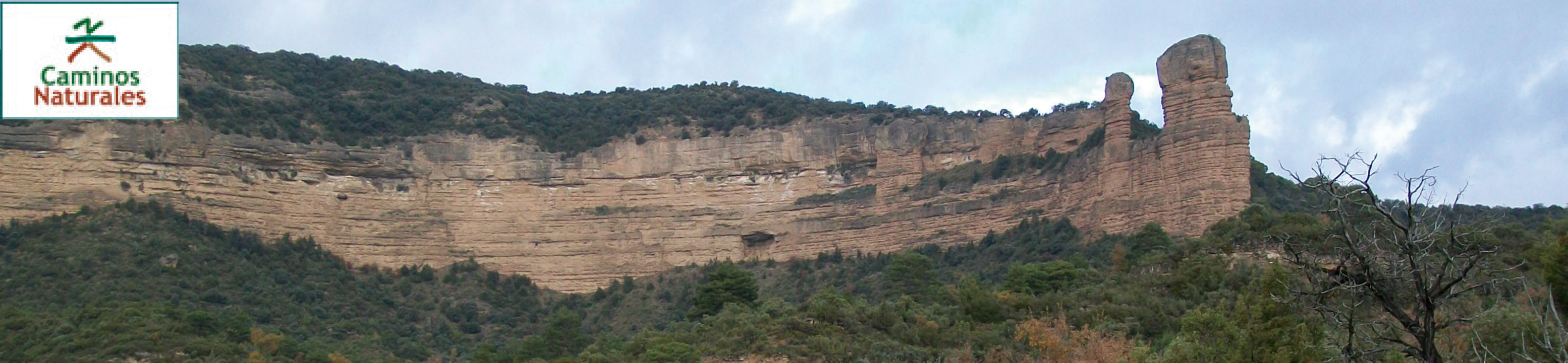
The next strecht is a tough uphill walk on a path that takes you to a viewing point that offers a fabulous view of the surrounding mountain ranges. To the south you can see the Peña Falconera or Huevo de Morrano, as it is known locally, a unique rock formation caused by erosion that stands out over the forest that spreads out over the slopes, and is home and nesting place to a population of griffon vultures (Gyps fulvus). To the east, the viewing point looks out over the river canyon.
The route then leaves the viewing point and sets off along the same path. A small trail to the left heads down to the river on its way to the hermitage of San Martín, a simple building next to the river itself, just under the rock face whose summit is the viewing point you left a little while ago.
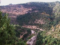
The Route then drops sharply and enters the dense pine forest of Morrano that you saw from the viewing point. After passing over a small hilltop, the route continues on the hillside right under the Huevo de Morrano and takes you to a crossroads. Go right and continue until you come to the village of Morrano.
Take the track that sets off to the south east, an old bridle path that goes down to the river Alcanadre. For the first kilometre or so you can see the south face of the Huevo de Morrano to your left.
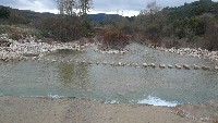
Then you arrive at the river Alancadre at a point called Fuente Tamara. This beautiful stretch of the river forms a natural swimming pool created by the water that runs down from the Fornazos coming together with water that filters through the limestone of La Tamara. This place is very popular locally and has a rest area. Some large stone blocks have been put in place as stepping stones to enable you to cross the river Alcanadre. Although it doesn't often happen, the river sometimes floods here and when it does, this crossing point is impassable.
Mixed vegetation of pine, holm oak, gall oak and abundant scrubland are the main feature of the last kilometres of the Somontano Nature Route, which heads away from the river along a track that goes up a hillside. Along the way you cross the ravine of Tamara and come to the Fuente de Puntillo, a beautiful series of small waterfalls that pour out from emerald green rock pools. In this section of the route the river Alcanadre (now on the right hand side) once again runs between rock faces in an area called Estrechos del Puntillo.
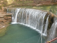
The trail starts to broaden and you can see changes in the vegetation, with areas of pasture and cropland. Turn to the right and the trail comes to a parking space for the leisure area that has taken shape around El Salto de Bierge, an old weir once used to supply a watermill and a small hydroelectric plant, and that has now become one of the most popular places in the Sierra de Guara to cool down in the hot summer months. Access to the area is controlled and you have to buy an entrance ticket in the peak season (more information and ticket buying at https://saltodebierge.info/).
The spectacular sights of the Somontano Nature Route end here, but there is a direct connection at this point with the Hoya de Huesca Nature Route, where you can carry on discovering just how beautiful the province of Huesca really is.
Sites of interest
Profile
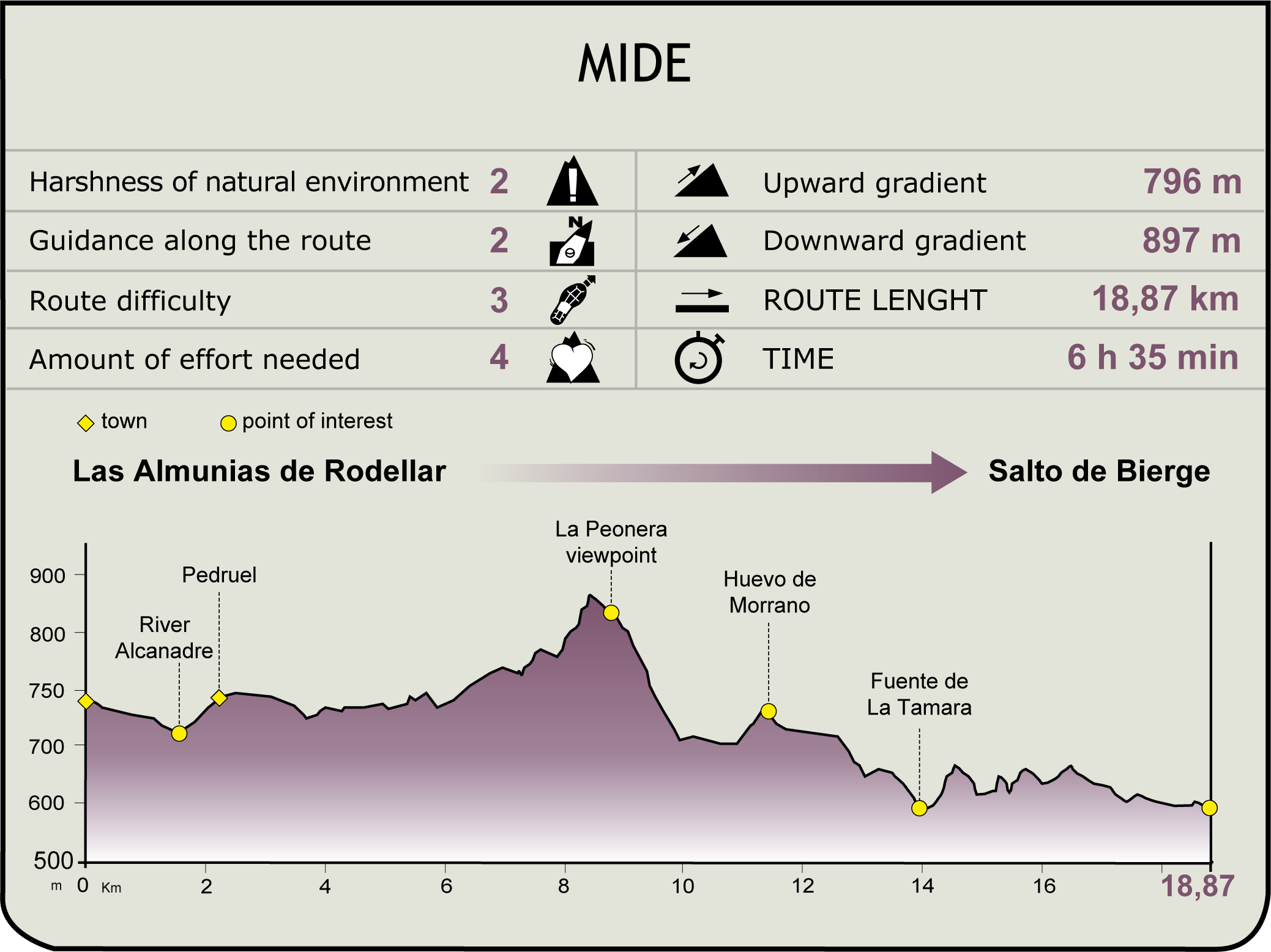
MIDE (Method for the Information of Excursions)
 Harshness of natural environment
- 1. The environment is not risk-free
- 2. There are more than one risk factors
- 3. There are various risk factors
- 4. There are quite a lot of risk factors
- 5. There are many risk factors
 Guidance along the route
- 1. Well defined trails and crossings
- 2. There is a clearly marked trail and signage
- 3. Requires the identification of geographic features and cardinal points
- 4. Requires off-path navigation
- 5. The trail is interrupted by obstacles that have to be gone around
 Route difficulty
- 1. Walking on a flat surface
- 2. Trails with different types of path
- 3. Walking on stepped paths or irregular terrain
- 4. The use of hands or jumping over the terrain is necessary
- 5. The use of hands is required to progress
 Amount of effort needed
- 1. Up to 1 hour of continuous walking
- 2. Between 1 and 3 hours of continuous walking
- 3. Between 3 and 6 hours of continuous walking
- 4. Between 6 and 10 hours of actual walking
- 5. More than 10 hours of continuous walking
Featured
Further information
Sierra y los Cañones de Guara Natural Park
The Sierra y los Cañones de Guara Natural Park is the largest Protected Natural Space in Aragon, with 47,637.66 hectares of Natural Park and 34,064.63 hectares of Protected Outlying Areas.
The Sierra de Guara Natural Park lies in the centre of the area called the pre-Pyrenean ranges of Huesca, which despite its name extends out over both sides of the range for 40 km and includes other smaller mountain ranges. The highest points are Tozal de Guara (2078 m) and the Tozal de Cubilas (1942 m)
The limestone that is a predominant feature in the Natural Park has created a landscape shaped by water erosion, with caves and chasms, upwellings, sinkholes and the rock formations typical of the region of Hoya de Huesca: the "mallos".
One of the most notable features of this mountain region is the contrast between the vegetation in the northern and southern areas.
The south consists of Mediterranean and continental ecosystems, where holm oaks (Quercus ilex) are common, replaced by Mediterranean scrubland in more desolate areas and Portuguese oak (Quercus faginea) in the lower valleys. Higher up you'll find European box (Buxus sempervirens) on the slopes and gall oak (Quercus cerroides) in the shaded areas of valley bottoms, and Scots pine in the sunlit areas. Box trees are replaced by broom (Echinospartum horridum) in stonier terrain. Rocky outcrops and ledges are colonised by highly specialised plants, some of which are unique to the region, such as the "romperrocas de Guara", a type of carnation (Petrocoptis guarensis) or the rosette mullein (Ramonda myconi).
The north on the other hand does not experience the dry seasons typical of the Mediterranean. which allows Euro-Siberian ecosystems to appear. The gall oak takes the place of the holm oak, while higher up the Scots pine (Pinus sylvestris) starts to predominate. Valleys with deeper soils may be home to small groves of silver firs (Abies alba). The slopes may also contain some local species such as columbine (Aquilegia guarensis) or scurvy grass (Cochlearia aragonensis).
The unique nature of the terrain has enables many cliff-nesting birds to make it their home: griffon vultures (Gyps fulvus), Egyptian vultures (Neophron percnopterus), lammergeyers (Gypaetus barbatus), golden eagles (Aquila chrysaetos), eagle owls (Bubo bubo), Bonelli's eagles (Aquila fasciata). Birdlife is also abundant in the forested areas: black woodpeckers (Dryocopus martius), short-toed eagles (Circaetus gallicus), booted eagles (Hieraaetus pennatus), the common pern (Pernis apivorus), etc.
Local mammals include roe deer (Capreolus capreolus), boar (Sus scrofa) and otters (Lutra lutra), along with small predators such as badgers (Meles meles), common genets (Genetta genetta), and a growing population of Spanish ibex (Capra pyrenaica). Some local species of amphibians and reptiles are of special interest, including the Pyrenean newt (Calotriton asper, only found in the Pyrenees and pre-Pyrenees), the ladder snake (Zamenis scalaris) and the asp viper (Vipera aspis). The predominant species of fish in the region are the common trout (Salmo trutta) and the barbell (Luciobarbus bocagei).
Invertebrates in the area include the white-clawed crayfish (Austropotamobius pallipes) and over 130 species of butterfly.
The Natural Park is also home to an extensive historical heritage. The region has been occupied since prehistoric times, evidence of which can be seen in the rock art of the Upper Palaeolithic (40000 BCE to 10000 BCE) in Cueva de Fuente del Trucho, along with examples of Levantine art (8000 BCE - 3000 BCE) on the slopes of the river Vero and Schematic art (5000 BCE - 1500 BCE). Megaliths of the 3rd millennium BCE can also be found in the area.
This heritage has increased over the centuries with the construction of castles and fortifications, churches, weirs and mills, etc.
While traditional farming, livestock keeping and forestry activities have seen a downturn in recent decades, there has been a growth in tourism and leisure, with activities such as canyoning, hiking and mountaineering, which have opened up new sources of income for the local residents of the Natural Park.
River Alcanadre. Bridge of the watersThis river’s name comes from the Arabic Al-qanatir,the plural of Al-qantara and means “the river of the bridges”. It is the longest and fullest river of those that cross the outer Sierras of Huesca, although its regime is very irregular and runs both high and low depending on the year.
It owes its name to the fact that, from its source in the Sierra of Galardón as far as its mouth on the River Cinca, in the town of Ballobar, the remains of sixteen old stone bridges have been preserved.
This river crosses the Sierra of Guara and forges deep ravines, canyons and gorges, which, every year, welcome canyoners of all nationalities. The four sections that are formed are called Gorgas Negras (the hardest Stage for canyoning in the whole sierra), Barrasil, Peonera Superior and Peonera Inferior.
Its most important tributaries are the Rivers Balcés, Mascún, Flumen and Guatizalema.
Out of all the old bridges that have remained standing, the purpose of the bridge of “Las Aguas” of Bierge or of “as cabras”, which has not been used since 1994, was to facilitate the traffic of goods that were headed towards the high lands of El Sobrarbe, and passed through Bierge towards Casbas and from there to the plateau of La Hoya de Huesca. It also formed part of a Royal Path from Huesca to Alquézar.
This bridge dates back to the late 16th or early 17th century. When it was in use, it was formed of two pointed arches separated by a pillar that rested on a rocky area of the river and upstream it had a triangular breakwater with a pyramidal structure. On the arches, there rested a gabled, paved, slightly tilted deck, whose centre was approximately at the point where it met the dome of the breakwater. The bridge channelled the current via fan-shaped, staggered flaps and was built out of blocks joined together with mortar and in regular rows.
At the present time, following its collapse, the only elements still remaining are the abutments, which are partly resting on the rock, the central pillar and the stem of the arches on both sides.
Multimedia