- Home
- Rural Development
- Nature Trails
- Nature Trails
- Northeast Sector
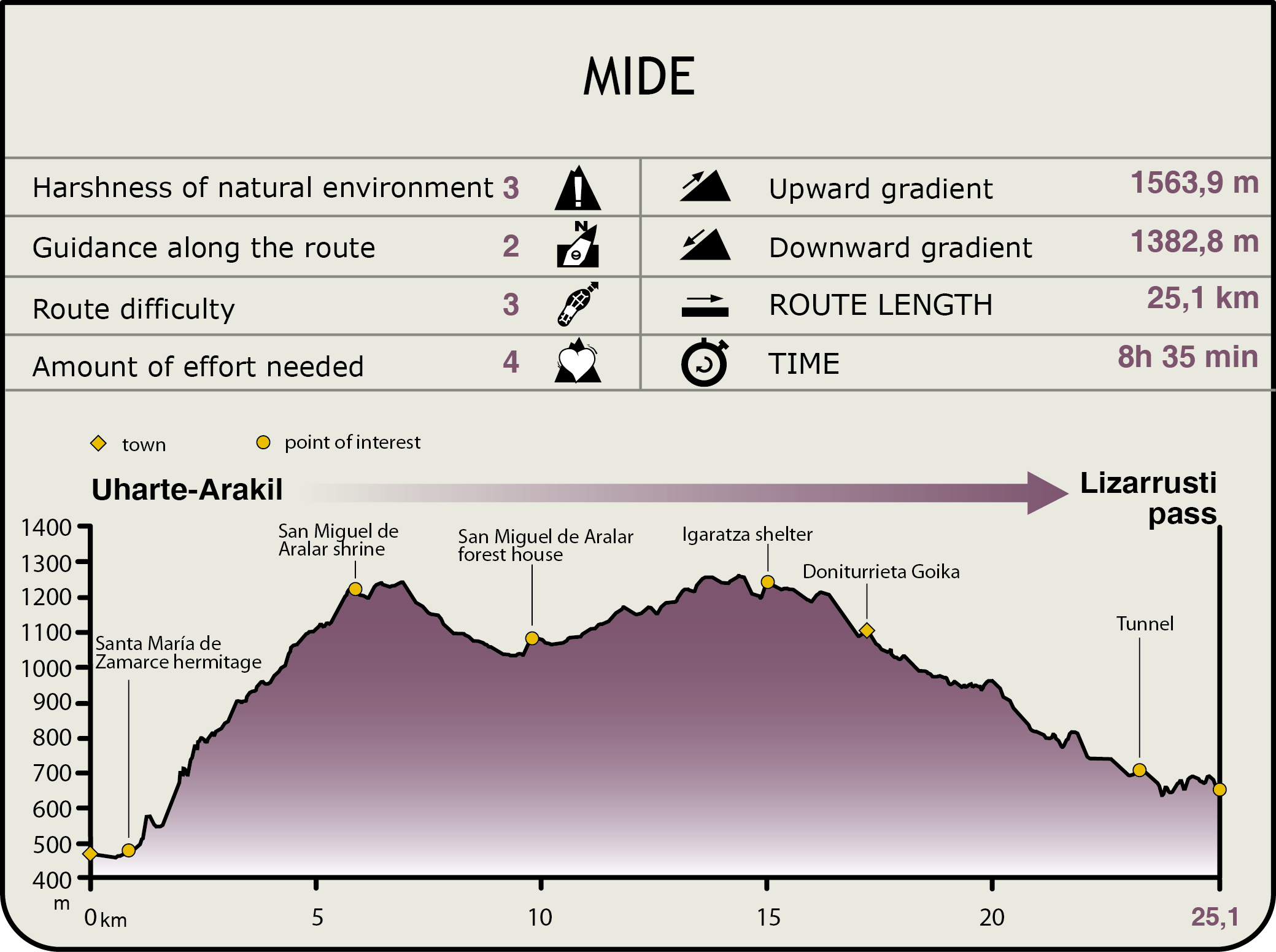
Stage 17: Uharte Arakil - Lizarrusti
Description
Discovering the Sierra of Aralar
This stage runs through the Sierra of Aralar, a karstic mountain range marked by its biogeographical proximity to the Pyrenees, which constitutes the geographical boundary between the Cantabrian and Mediterranean watershed. It is an area with important beech groves although it also offers interesting examples of Holm and gall-oak groves, as well as rocky and flat pastoral landscapes that bear witness to countless generations of shepherds who have known how to live on this land in perfect harmony, bequeathing a landscape of considerable wealth and great scenic beauty.
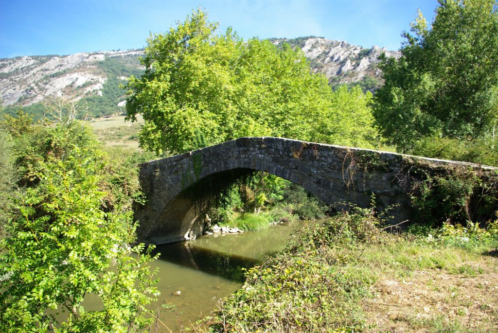
The stage begins in Uharte-Arakil, from the church of San Juan Evangelista along Ibaiko street northwards. After passing by the last house in the town, you cross over a bridge on the River Araquil, and continue along the NA-2410 highway to the right for 500 m. On reaching the vicinity of the chapel of Santa María de Zamarce, you take a turn-off on the left that leads to the Sanctuary of San Miguel de Aralar. After covering some 600 m along this road, you should leave it and take an uneven, stony path that emerges on the left. The trail zigzags up a steep, tree-covered slope for 4.5 km and with a difference in altitude of 700 m, until you come to Mount San Miguel (1.296 m), where the sanctuary stands at the top of the Sierra of Aralar. During your climb, you can contemplate, close to the path, megalithic remains such as the dolmen of Artzabal and the dolmen of Otsopasaje, as well as extremely beautiful mixed forest formations, where gall-oaks (Quercus faginea) and Holm oaks (Quercus ilex) intermingle with small beech tree (Fagus sylvatica) woods and with a varied shrub layer of maples (Acer sp.), hawthorns (Crataegus monogyna), heathers (Erica sp.), euphorbias (Euphorbia sp.), may thorns, winter roses, etc., which make the tough climb more pleasant.
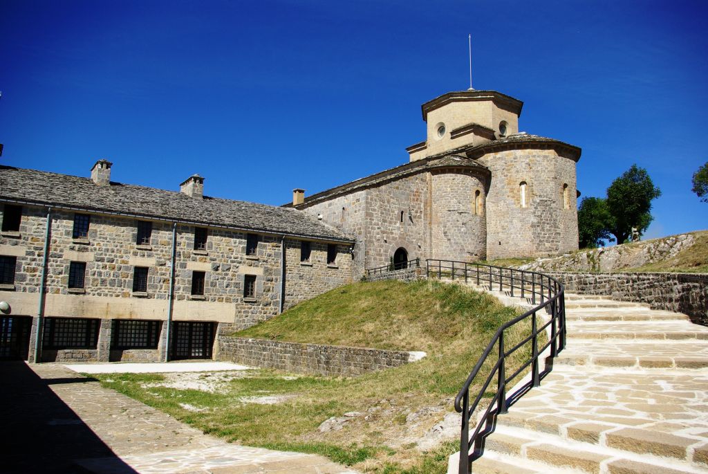
On reaching Mount San Miguel, next to the sanctuary, you can enjoy magnificent views of the corridor of the River Arakil and of the Sierra of Andía and San Donato. You can also see the sanctuary itself; a Romanesque site which, according to research, was built in the 12th century from a 9th-century temple that was almost completely destroyed in a Muslim advance and of which some remains of the original wall were allegedly used.
From the sanctuary, you continue northwards following a line of ash trees (Fraxinus sp.), until you intersect the NA-7510 highway, which you will have to walk down, to the left, for 3.5 km. In this part of the stage, you cross an extensive beech grove until you get to the forest house of San Miguel de Aralar. This tree species is the main forest formation of the Sierra of Aralar.
At the forest house, you take a gravel track that emerges in a westerly direction, along the path of Igaratza; a climb of some 4.5 km with an incline of 250 m, among beech tree stands as far as the last part of a treeless area, with pastures and limestone outcrops, until you come to a crossroads where the route leaves the track along a path to the left.
From this crossroads, there are a little over ten kilometres of the stage left, all downwards. A few metres after taking the turn-off, the trail enters the communal lands of the Community of the Sierra of Aralar, in the mountain area belonging to the region of Goierri (Gipuzkoa), an area declared a Natural Park. You then enter the territory of the Gipuzkoa municipality of Ataún.
The trail continues along a stony path that runs along the head of the ravine of the stream of Zamiola —a tributary of the River Maizegi—, where you come to the chapel of Igaratza and the shelter of Igaratza, surrounded by ash trees. The chapel was built in 1946 by the Friends Society of Aralar so that mountaineers and shepherds could attend Sunday mass. Since then, every August 15, true to tradition, the Archangel San Miguel is taken on a pilgrimage from the Sanctuary of San Miguel to the chapel of Igaratza to greet the Cross of Igaratza, accompanied by hundreds of mountaineers.

Following the path, leaving Igaratza behind you, you once again join the track you just left. Via this track, you descend the flatlands of Olamuno and the Txalburu and the slopes of the “Karst de la Sierra de Aralar”, which you leave at the top on the right. You walk parallel to the River Maizegi or Zamiola, which flows along the bottom of the valley on the left, with the wooded slopes of the Sierra of Akaitz behind you.
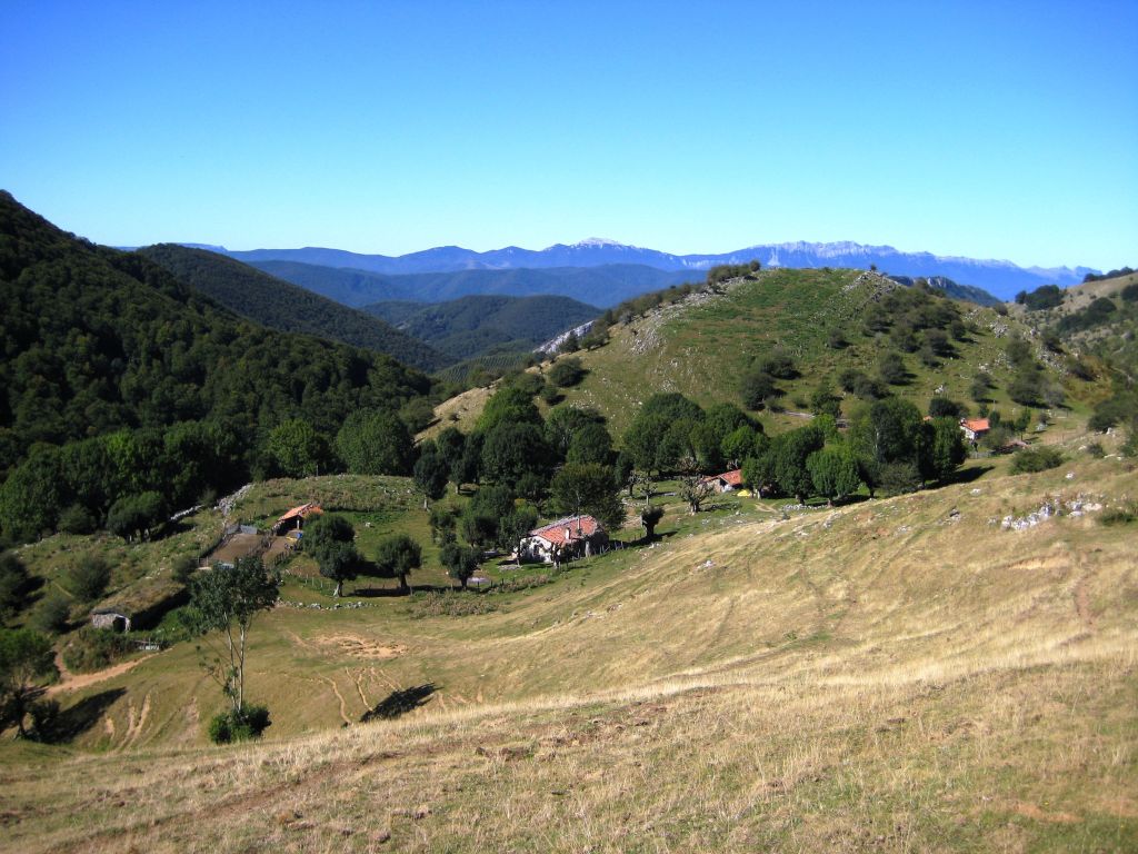
The track leads to the shack district of Doniturrieta Goika, which lies in a small depression in the land and is surrounded by trees, sheltered from the mountains’ harsh weather conditions. A path emerges from among the shacks, which runs across the hillside, following a line of hawthorns, and, further on, across a brushwood area for 2.5 km until it arrives at a cabin, in the ravine of Enirio.
Two elements of geological interest are located in this area: a degraded glacial cirque and the dome of Ataún. This is a unique geological structure, formed by the joint action of the forces stemming from the Pyrenean orogeny and some local forces that caused the surface to rise, forming a dome-shaped hill. As a result of the differential erosion of the diverse rock types that form it, the dome produced its current ring shape.
The trail continues to descend down a path, the path of Enirio, following a small stream that forges its way through the ravine of Baiarrate, between the mountains of Akaitz Txiki and Arrate Beltza (or the Sierra of Sarrastari).
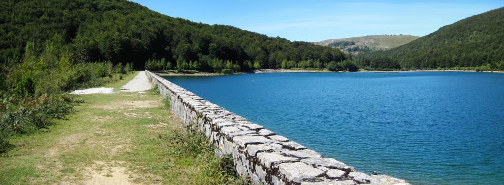
Further on, you join a track that you should follow rightwards for 400 m as far as the first turn-off you come to on the left. You take a track that borders the reservoir of Lareo, crossing a wooden walkway. On the banks of the dam, close to the Trail, you will come to the dolmen of Lareo. The body of water shapes a landscape of great beauty together with the surrounding beech groves. No sooner do you pass over the dyke than you should take a turn-off to the left along a track that heads downstream next to the reservoir. The route continues along a path that quickly intersects the stream of Agauntza; the stream forges its way through a valley boxed in between the mountains of Alleko (on the left) and Malkorburu (on the right), forming very beautiful tiny waterfalls.
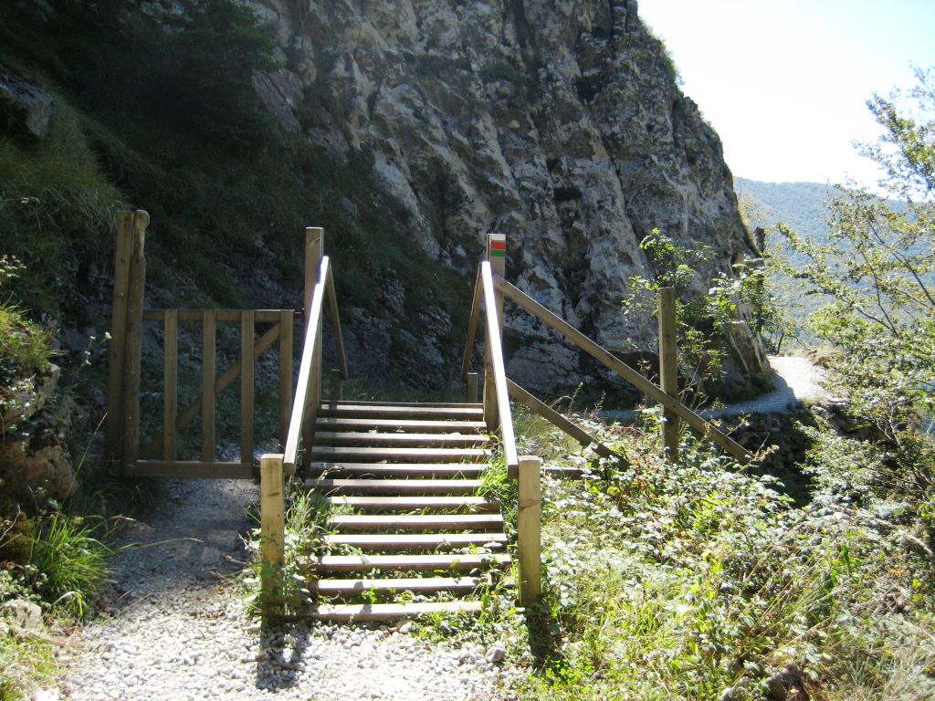
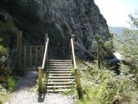
The route continues along a narrow path that winds its way across the rough hillsides of Mount Alleko, inside the Valley of Agauntza or of Maizegi, for 1.5 km, and crossing an impressive oak and beech grove mass as far as Lizarrusti. In this stage, there are some narrow passes in very steep areas where need you to pay great attention to the path; for this purpose, some ropes have been fitted making it safer for trekkers. You should cross via a tunnel excavated into the rock—the tunnel of Akerreta— and then you will come to a fountain with the same name.
Once you have crossed this final rough part, you will come to the pass of Lizarrusti, the end of the stage. At this point, located at an altitude of 635 m on the boundary between Gipuzkoa and Navarre, you will come to the interpretation centre of the Natural Park of Aralar, which features a hostel and a restaurant, where you can regain your strength for the next day.
This is a stage that has many obstacles for cyclists. The first is the climb to the Sanctuary of San Miguel de Aralar, although you can overcome it by using the road. The second obstacle for cyclists is the part that accesses the chapel of Igaratza, although it can also be overcome by cycling on the track bordering it. Finally, cycling is very difficult, if not impossible, due to the surface from the shack district of Doniturrieta Goika to the end of the stage; especially in the last part, along the gorge of the River Agauntza, where it would be reckless to cycle as it is not even easily covered on foot.
Profile
MIDE (Method for the Information of Excursions)
 Harshness of natural environment
- 1. The environment is not risk-free
- 2. There are more than one risk factors
- 3. There are various risk factors
- 4. There are quite a lot of risk factors
- 5. There are many risk factors
 Guidance along the route
- 1. Well defined trails and crossings
- 2. There is a clearly marked trail and signage
- 3. Requires the identification of geographic features and cardinal points
- 4. Requires off-path navigation
- 5. The trail is interrupted by obstacles that have to be gone around
 Route difficulty
- 1. Walking on a flat surface
- 2. Trails with different types of path
- 3. Walking on stepped paths or irregular terrain
- 4. The use of hands or jumping over the terrain is necessary
- 5. The use of hands is required to progress
 Amount of effort needed
- 1. Up to 1 hour of continuous walking
- 2. Between 1 and 3 hours of continuous walking
- 3. Between 3 and 6 hours of continuous walking
- 4. Between 6 and 10 hours of actual walking
- 5. More than 10 hours of continuous walking
Featured
Further information
Remains from the past
This stage allows you to enjoy one of the most impressive natural environments of the northern peninsula and, in turn, to marvel at the remains of ancient human occupation.
The first shepherds and farmers occupied Aralar and there are numerous megalithic remains in its surrounding area. Worthy of note is the existence of caves containing remains of tools, which date human presence back to 27.000 years ago. The many dolmens are especially appealing; prehistoric remains enthusiasts will enjoy the beginning of the route, as you can see some of them on the path of the Sanctuary of San Miguel. If you are interested in finding out more, you can take a break from your route and opt for momentarily swapping the Grazing Trail for the Path of the Dolmens, a 15 km-long circular route where you can see ten dolmens: Beitzeta, Iruiturrieta, Jentiltzulo, Benintxar, Irumugarrieta, Zalatamuno, Mintegitxuta, Txaradigorri, Fagamendi and Maitzegur. The mountains are home to a total of 44 dolmens and a menhir.
Aralar Natural Park and SCI, Sierra of Aralar SCI
The massif of Aralar features natural values that make it worthy of the protection figures of Natural Park and Site of Community Importance, which continue into the provinces of Navarre and Gipuzkoa. It is one of the most important mountainous areas in the environment in terms of altitude, expanse (10.971,05 ha), land uses, natural values and landscape importance. It is located to the southeast of Gipuzkoa and borders with the Navarre sector of the same mountain range. In Aralar, the land has two production uses, livestock farming and forestry — conifer plantations—. It is a territory with a great shepherding tradition, boasting a considerable flock of “latxa” sheep and numerous shepherd huts spread around the mountains.
The central and eastern area of the mastiff, the highest, is dominated by pastures used extensively by a considerably flock of “latxa” sheep, with almost no forests. In the southern area, there are large forest masses formed of beech groves, Holm oak, gall-oak and Cantabrian Holm oak. Next to the waterways and in humid areas, Cantabrian alder groves prevail. There are also seven endemic species that are only known in Aralar.
The fauna community in Aralar is extremely rich as it represents a link between the Cantabrian and Pyrenean mountains and is a dispersal area for the species in these regions. One such case is the bearded vulture (Gypaetus barbatus), which, although it is not present in the area on a regular basis after it disappeared as a nesting bird in the 20th century, specimens from the Pyrenees can be frequently seen, especially in winter.
Multimedia