- Home
- Rural Development
- Nature Trails
- Nature Trails
- Northeast Sector
Stage 13: San Vicente de Arana - Urbasa
Description
"La Parzonería de Entzia"
This stage passes through heights of over 1.000 m, along the crests of the mountains of Iturrieta, the Sierra of Entzia and the Sierra of Urbasa, with fabulous views of the surrounding area and especially of the Llanada Alavesa. Almost the entire route runs through a range of natural protected spaces, with majestic beech groves and outcrops. The stage ends in the middle of the Natural Park of Urbasa and Andía, in Navarre territory. You cross several areas with an extensive herding tradition, such as the Parzonería de Entzia, where, since bygone times, the pastures and forests have been used communally.
This stage begins in San Vicente de Arana, taking an asphalted road that climbs northwards. You pass by the cemetery and next to a park where the “Mayo” monument is erected. You keep on in this direction, leaving a cattle grid behind you, and immediately take a turn-off to the left, along a dirt road, which climbs the slopes of Mount Bitigarra. You carry on for about 1.5 km under the tops of a beech grove as far as the chapel of Santa Teodosia, from where you can contemplate beautiful views of the Valley of Arana. In the vicinity of the chapel, there is an open space with a rest area, where hundreds of people gather for the pilgrimage of Santa Teodosia, which is held in the month of September. Worthy of note is the presence of an enormous ash tree (Fraxinus excelsior) next to the chapel, which is catalogued as an Exceptional Tree.
The trail continues through the municipality of Arraia-Maeztu, crossing an open space in a northerly direction and taking a forest track that once again enters a beech grove. Little by little, the beech grove gives way to other less demanding forest formations, containing gall-oaks (Quercus faginea), junipers (Juniperus sp.), hawthorns (Crataegus monogyna), Holm oaks (Quercus ilex), etc., which are strewn across an area that is unsuited to agricultural. The trail finally joins a farm track that leads to Roitegui, a town established on the banks of the gully of Igoroin, which, located at a height of some 948 m, is the second highest town in Álava. It was the Lordship of the Gaona, Ayala, Salvatierra and, finally, of the Porceles families—Marquises of Villa Alegre- and an important place as it was the intersection of paths through the passes of Opacua and Eguileor. Worthy of note in this town is the parish church dedicated to San Pedro, where a fronton-tennis court has been built nearby.
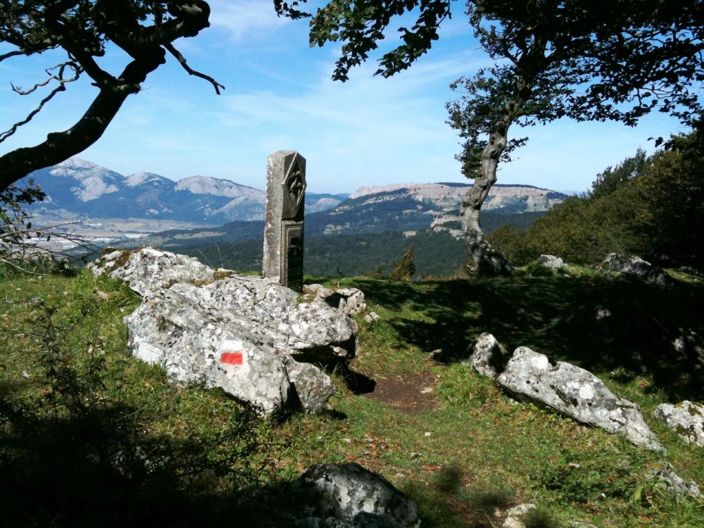
On the outskirts of Roitegui, you should take, in a northerly direction, a gravel farm track that crosses an extensive crop field and heads towards the mountains of Iturrieta. When you reach the foot of the mountains, the track intersects another that continues to the right, immediately taking a turn-off on the left. This is an uneven, stony path that climbs up the southern slope for some two kilometres, with a difference in altitude of 150 m, as far as the ridge of the mountains of Iturrieta. The final stage of the ascent goes across fields, following a cattle enclosure that is the border between the municipality of Arraia-Maeztu and the Parzonería de Entzia. At the top, the ridge of the mountains of Iturrieta is crowned by the Atxuri peak, where a geodesic milestone is located. This point is a natural privileged lookout, from where you can contemplate the Llanada Alavesa towards the north, located at the foot of the mountains of Iturrieta, and the Sierras of Aralar and Aizkorri-Aratz in the background, which mark the northern frontier of the Plain. You can also see the Iturrieta mountain range, which the trail crosses following the Sierras of Entzia and of Urbasa and Andía in an easterly direction. Together with the Montes de Vitoria, they form a mountain chain that serves as the southern boundary of the Llanada Alavesa.
From Atxuri, you cross the cattle enclosure and continue eastwards along the ridge of limestone crests of the mountains of Iturrieta, covering the top part of the Parzonería de Entzia. The route runs along a mountain path that follows the mountain ridge, crossing between a mosaic of pastures, crags and beeches (Fagus sylvatica), through the pass of Alangua. After some two kilometres and a final slope, you come to the peak of Arrigorrista, from where you abruptly descend for 1.5 km through the thickness of a beech grove as far as the Puerto Viejo and the pass of Opagua, where the A-2128 highway, which links the Llanada Alavesa to the Valley of Arana, crosses.
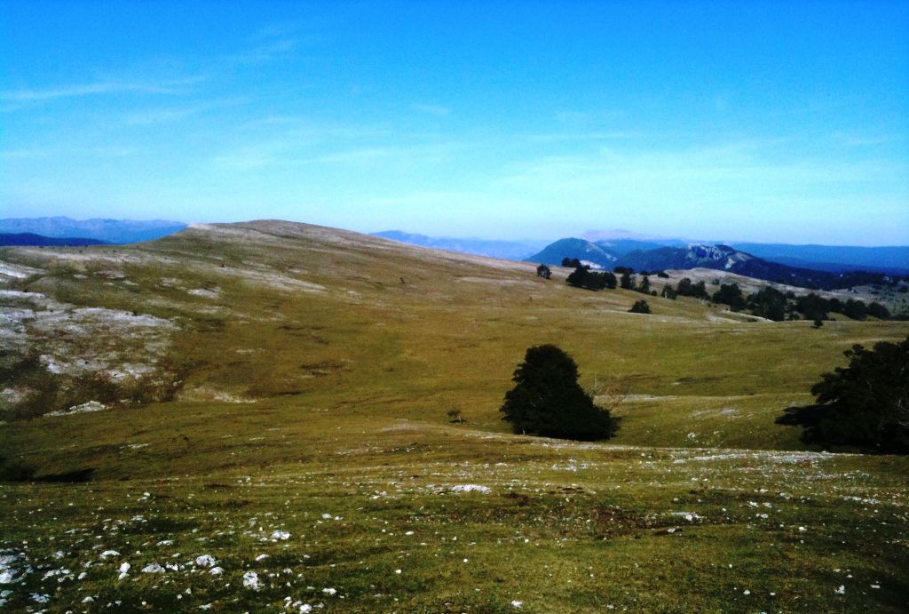
You should cross the A-2128 highway and continue across the flatlands of Zizama, on an asphalted road that runs next to a plantation of Lawson cypresses (Chamaecyparis lawsoniana), towards the Sierra of Entzia - the continuation of the mountains of Iturrieta towards the east. On reaching some cattle panels, you should take a turn-off on the left, following a path that runs across a treeless strip that crosses a coniferous plantation. After a short climb, you reach the Majada de Zalanportillo, an extensive grazing area strewn with shacks and shepherd huts and some beeches that serve as shelter for the flocks grazing there.
Profile
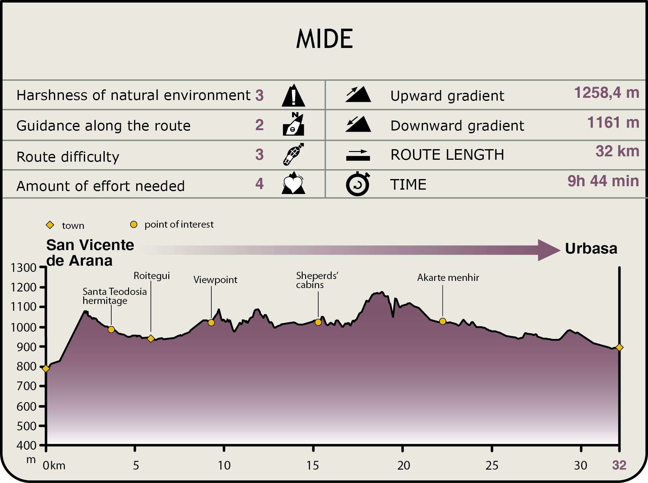
MIDE (Method for the Information of Excursions)
 Harshness of natural environment
- 1. The environment is not risk-free
- 2. There are more than one risk factors
- 3. There are various risk factors
- 4. There are quite a lot of risk factors
- 5. There are many risk factors
 Guidance along the route
- 1. Well defined trails and crossings
- 2. There is a clearly marked trail and signage
- 3. Requires the identification of geographic features and cardinal points
- 4. Requires off-path navigation
- 5. The trail is interrupted by obstacles that have to be gone around
 Route difficulty
- 1. Walking on a flat surface
- 2. Trails with different types of path
- 3. Walking on stepped paths or irregular terrain
- 4. The use of hands or jumping over the terrain is necessary
- 5. The use of hands is required to progress
 Amount of effort needed
- 1. Up to 1 hour of continuous walking
- 2. Between 1 and 3 hours of continuous walking
- 3. Between 3 and 6 hours of continuous walking
- 4. Between 6 and 10 hours of actual walking
- 5. More than 10 hours of continuous walking
Featured
Further information
La Parzonería de Entzia
A good part of this stage runs through the lands of the Parzonería de Entzia. A “parzonería” is a figure for joint and several use of the mountains, originating in the Middle Ages, which grants a series of municipalities and / or towns their ownership and enjoyment. It is a figure that pertains to southern Gipuzkoa and northern Araba/Álava. The term is regarded as a localism; the word comes from the French parçonier, meaning participant, which is the origin of the Basque word partzuergo that refers to each of the participants in the usage system.
Its main difference with respect to similar figures, such as the Town Communities, is that, whereas in the latter the shared lands come from the same source, namely a town or a municipality that was subsequently split into different entities that kept their property and land use rights, a “parzonería” is the result of the union of separate entities which, caused by different ties, generally neighbourhood-related, undertake the process of purchasing different mountain areas.
The “parzonería” has two basic economic channels, the exploitation of wood and cattle farming. A total of 4.000 “latxa” sheep plus 1,000 heads of beef cattle and 400 horses have been counted in its area. Part of the assets of the “parzonerías” is used directly by the “partzuergos”, whereas others are intended for sale.
Although in theory the lands that form part of the “parzonería” cannot be split, in practice the “partzuergos” create different lots or portions that match the efforts made by each of them in purchasing the mountain areas.
The “Parzonería General de Entzia”, which accounts for almost 3.500 ha, comprises the municipalities of Salvatierra, San Millán, Aspárrena and Zalduondo and the villages of San Vicente de Arana, Alda, Ullibarri, Arana, Contransa, Onraita and Roitegui.
There are other “parzonerías” such as that of Entzia de Arriba, Apota-Ubarrundia, Iturrieta, Parzonería de Gipuzkoa (Komuntxiki) and the Parzoneria General de Gipuzkoa and Araba/Álava.
The trail continues along a path that follows a cliff for some five kilometres that climbs through the pass of Vicuña to reach the peak of Ballo (1.197 m) and the peak of Mirutegui (1.165 m), this section’s ceiling, with privileged views of the Llanada Alavesa and its surrounding area.
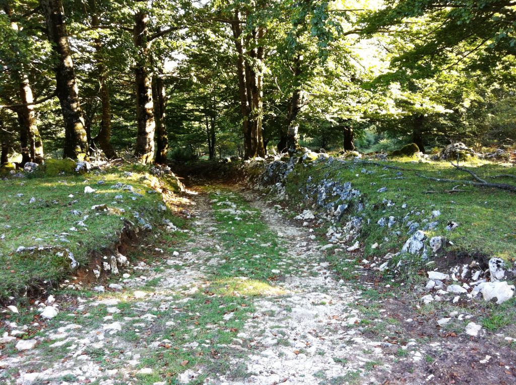
From here, you descend some 3.5 km, crossing the flatland of Lagaire. This is an extensive mountain grazing area on the high plateau of the Sierra of Entzia, which feeds numerous heads of cattle in the summer and autumn months. After crossing the flatland, you intersect —in Cuartandi— a gravel forest track, which you should take leftwards. After a gentle climb, you enter a large beech stand that affords shade for the roughly nine kilometres of gentle descent remaining until the end of the stage. After covering the first three kilometres of beech grove, the path passes through Navarre territory, leaving the province of Álava behind. This part runs across forest tracks, which, although slightly uneven, afford a pleasant walk, in comparison with the previous crest sections. In this part, in addition to the predominance of beech groves, you can also see some Lawson cypress plantations and Scots pines (Pinus sp.). Half a kilometre before you reach the end of the stage, the path leaves the beech grove and emerges onto the Majada de Bidoiza, where you can see, at the foot of the path, a shepherd’s hut and the keeper’s lodge. You finally come to the end of the stage at a campsite, which offers accommodation services (campsite, bungalows and a hostel) and a restaurant for trekkers. The campsite is located in the middle of the Natural Park of Urbasa and Andía, at the foot of the NA-718 highway, its main entrance. Staying at the campsite enables you to feel the sensation of spending the night in the mountains, as the shepherds used to do. Continuing along the NA-718 highway northwards, 1.5 km from the campsite, you come to the Park information centre, where you can consult all kinds of information on the area.
Entzia SCI
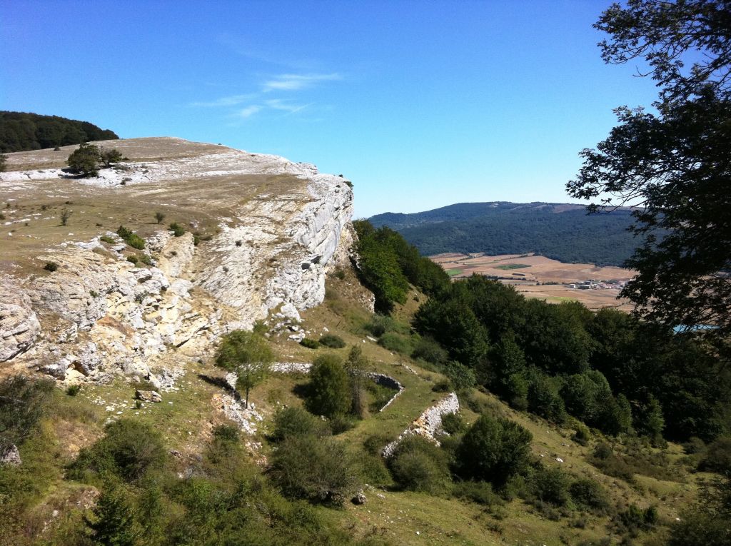
The Site of Community Importance, Entzia SCI, is a continental SCI spanning 9.931 ha, located in Álava. It is a plateau that rises abruptly between the Llanada Alavesa and the Valley of Arana, and continues with the Navarre mountainous reliefs of the Sierra of Urbasa, to the east, and with the Montes de Vitoria, to the west. Karstic phenomena affect the large parcel of limestones and dolomites in the upper portion, modelling a typical morphology of cracks, limestone pavements, sinkholes, etc.
The vegetation is characterised not only by the presence of mature beech groves, which include some of the best preserved trees in the Basque autonomous community, alternating with brushwood and pasture areas, but also by crag-related vegetation, with some endemic and endangered species. The mountains also feature wet areas —pools and ponds— which are considered to be of herpetological interest.
This stage is very tough for cycling. The first difficulty cyclists will meet will be the climb up to the chapel of Santa Teodosia, with very steep and stony, albeit short, inclines. The next obstacle will be the slope during the ascent up the mountains of Iturrieta, which crosses fields. And, finally, the most important, is the whole crest of the mountains of Iturrieta and the Sierra of Entzia, which runs along a mountain path that is very close to rocky cliffs and has a very uneven surface due to its rocky outcrops, which makes cycling extremely difficult. To sum up, a good part of the stage has very significant restrictions with respect to cycling.
Multimedia