- Home
- Rural Development
- Nature Trails
- Nature Trails
- Northeast Sector
Stage 6: Villalba de Losa - Bóveda
Description
The Valley of Losa
This stage runs through the Valley of Losa, which is renowned, among other things, for its seed potatoes, which gives you an idea of its physical geography. It features extensive farming areas surrounded by hills and mountains used for forestry and farming, which are of great scenic value. The path mainly runs across the top of the Peña Orduña and Sierra Salvada, formations that serve as a border between the plateau and the valleys of Cantabria, offering trekkers fabulous visits on both sides. These mountains comprise rich rangelands, which have been vitally important for this area’s livelihood and economy for centuries. This is evidenced by the existence of shepherds’ buildings and by the unique organisation of the territory, which, in the past, allowed communal use by all the neighbouring municipalities.
The route of Stage 6 mainly runs through the Valley of Losa, which is part of the region of Las Merindades, in the province of Burgos, although it makes some inroads into the territory of Araba/Álava. The high crest areas covered by the path are designated as Natural Protected Areas, specifically Mount Santiago SCI, Mount Santiago S.P.A. for Birds, Mount Santiago Natural Monument and Sierra Salvada S.P.A. for Birds. The Losa-Orduña IBA has also been designated in this area, given its importance for rock birds, such as the Egyptian Vulture (Neophron percnopterus), the Griffon Vulture (Gyps fulvus), the red-billed chough (Pyrrhocorax pyrrhocorax) and the Alpine Acccentor (Prunella collaris), among others.
The stage begins along an agricultural path that leaves Villalba de Losa in a westerly direction, next to a farm. You should turn right after travelling 1.5 km and then, after climbing slightly, you come to the top, where there are views of a small valley irrigated by the Zaballa stream. The town of Zaballa is located at the head of this valley, which you reach by descending a path that crosses a forest area of gall-oaks (Quercus faginea), pines (Pinus sp.) and maples (Acer sp.), whose colours are magnificent in the autumn. Zaballa is a small town where the architecture of the construction elements and buildings is traditional and based on the use of limestone slab (“Losa” in Spanish), which gives the valley its name.
After crossing the town, you take a narrow alleyway that begins at the main road towards the right, and turns into a path, which, after a little more than 1.5 km, leads to the next town of Mijala, where there are also interesting examples of traditional architecture.
After crossing Mijala, you leave northwards continuing along the road that accesses the town. A few metres later on, it turns into a gravel path that climbs some flat stones. Leaving a farm behind you, the route continues along a dirt path that crosses an extensive area of mountain pastures in the area surrounding Pozolagua, a water point that is used to quench the thirst of the abundant herds of cattle.
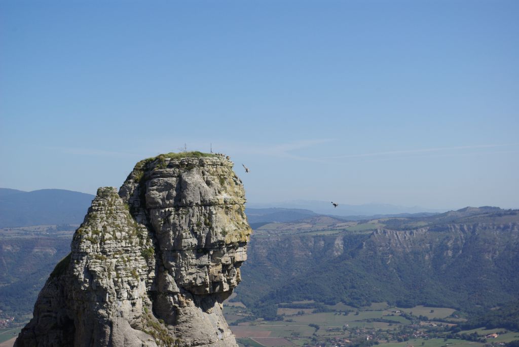
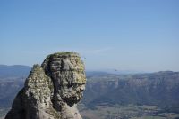
After covering four kilometres from the town of Mijala, you cross a loose gravel track that you should follow towards the left although, at this point, it is worth stopping to contemplate the impressive view of the outcrop of Orduña and the eponymous valley that stretches behind it. Worthy of mention is the Pico del Fraile or the Monk’s Peak, a rocky monolith that juts out from the cliff and which owes its name to its similarity to a monk’s silhouette. Griffon vultures are usually perched on this peak and hover around the rocky cliffs of Orduña. This alignment of rocky cliffs is home to a good deal of the rich bird life that has led to these natural spaces being declared as protected.
Following the route along a gravel path, you climb up the Charlazo for a kilometre as far as the Sanctuary of the Virgin of La Antigua or the Virgin of La Peña, located next to some telecommunications antennae. From here, you will have magnificent views of the Orduña Valley, where the River Nervión flows.
The path does not pass exactly next to the Sanctuary, which is a dozen metres away, but it is worthwhile taking a momentary detour from the route to visit it.
The path continues northwards following the rocky cliff, climbing up a very steep slope until it reaches the top part of the limestone mountain range of Peña Orduña. Its crest guides the path for some four kilometres along the boundary between the provinces of Araba/Álava and Burgos, leaving to the left an extensive plain known as “La Dehesa del Agua”, which is covered with a mixed forest mass formed of beeches (Fagus sylvatica), oaks (Quercus ilex), gall-oaks (Quercus faginea) and Scots pines (Pinus sylvestris), with a view on the right of Orduña Valley. The rocky outcrops of Peña Orduña are designated elements of geological interest.
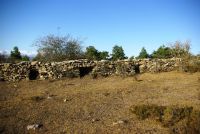
On this route along the crests of Peña Orduña, you climb up to the peak of Bidarbide, to then descend towards a beech-covered riverbed, known as the Barranco de Ponata. Animal pens or the “chaulas” of San Isuso, an area whose communal pastures are used by the residents of Orduña, Junta de Villalba de Losa and Ayala-Amurrio, have been built here. In your descent, after crossing a beech forest, you come to a gravel track which you have to follow to your left along the Lastra del Pozo, up a 200 m incline between pastures and limestone pavements and strewn with aged beech trees until you reach Loma Zacorta, which marks the beginning of Sierra Salvada.
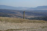
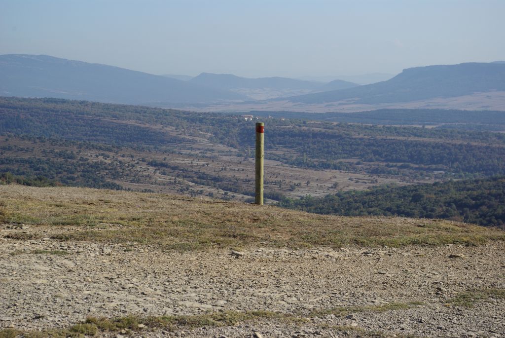
The path continues along the gravel track that runs lengthwise along the high plateau of Sierra Salvada in a north-westerly direction. The trail continues crossing vast expanses of pastures strewn with hills, sinkholes and gulleys proper to karstic structures while the whole area is surrounded by rocky escarpments and river ravines.
After gently descending via the track for roughly three kilometres, you come to a riverbed where the animal pens or “chaulas” of La Cobata are located. It is an area of rich pastures and scattered wooded areas, which features many shepherds’ huts and folds. After crossing this area, the trail leaves the path along a track, which, after crossing a hill covered with sparse vegetation, joins another one that leads to Barriga once again.
The route follows the track along the path to Bustantiego, descending gently for 5.5 km and avoiding the steep slopes of the ravines of Horcón and Las Tejas, caused by the effect of the water on the limestone mountain range. Once in Barriga, you take the main road that accesses the town in a southerly direction, running along the bottom of the Valley of Losa, for three kilometres, as far as Fresno de Losa. One of the best bowling alleys in Las Merindades is located in this town.
Taking an alleyway that leaves the town in a westerly direction, you continue along a forest path for 1.5 km in the shade of a mature mass of Scots pines. After climbing an incline of some 150 m, you reach the Peña de los Hoznadillos, located in a small range of hills that separates the Valley of Losa from the Valley of Valdegovía, now in the lands of Álava.
From this point, you descend a track some 3.5 km long that runs parallel to the stream of El Cascajo, crossing a mixed mass of Scots pines, gall-oaks and Holm oaks as far as the town of Quintanilla, where you can visit the Chapel of Nuestra Señora del Olmo and the Church of San Julián and Santa Basilia. From Quintanilla, you take the asphalted road that leads to the town, taking a turn-off one kilometre further on to the right along a gravel track that soon reaches the end of the stage in the town of Bóveda.
This stage is quite hard for cyclists. You have to “carry your bike on your shoulder” in some parts that are very awkward owing to their stoniness and steepness, especially the ascent from the Pico del Fraile to the top of the Peña Orduña, with an incline of over 200 m, and the climb to the peak of Bidarbide, in addition to other parts that are less firm and are not suitable for cycling either.
Profile
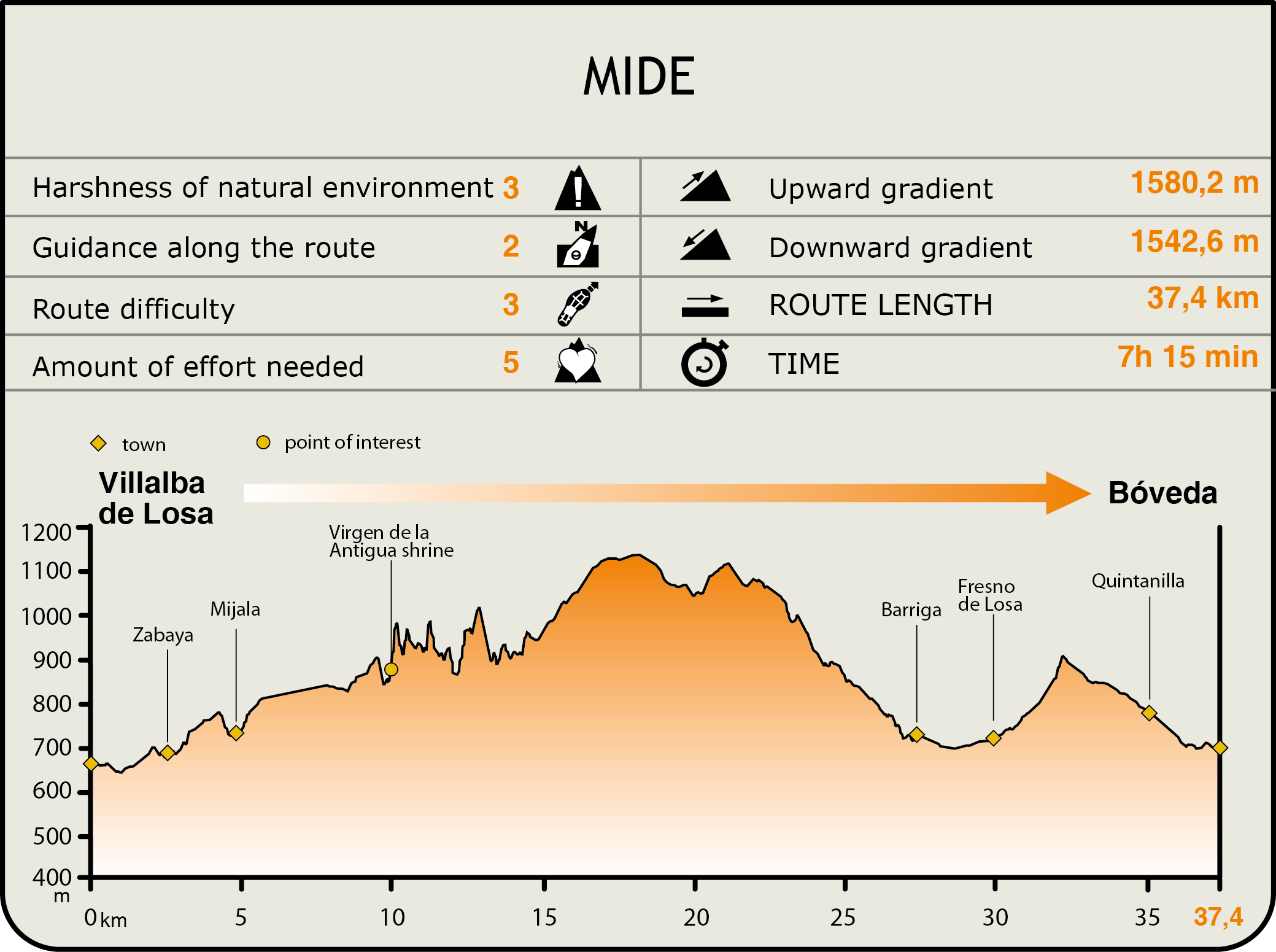
MIDE (Method for the Information of Excursions)
 Harshness of natural environment
- 1. The environment is not risk-free
- 2. There are more than one risk factors
- 3. There are various risk factors
- 4. There are quite a lot of risk factors
- 5. There are many risk factors
 Guidance along the route
- 1. Well defined trails and crossings
- 2. There is a clearly marked trail and signage
- 3. Requires the identification of geographic features and cardinal points
- 4. Requires off-path navigation
- 5. The trail is interrupted by obstacles that have to be gone around
 Route difficulty
- 1. Walking on a flat surface
- 2. Trails with different types of path
- 3. Walking on stepped paths or irregular terrain
- 4. The use of hands or jumping over the terrain is necessary
- 5. The use of hands is required to progress
 Amount of effort needed
- 1. Up to 1 hour of continuous walking
- 2. Between 1 and 3 hours of continuous walking
- 3. Between 3 and 6 hours of continuous walking
- 4. Between 6 and 10 hours of actual walking
- 5. More than 10 hours of continuous walking
Featured
Further information
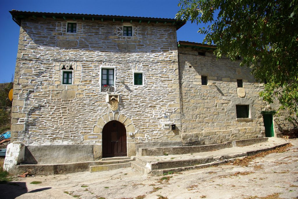
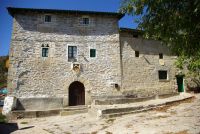
Architecture in the Valley of Losa
In addition to its eponymous municipality, the Valley of Losa region is formed of several others, such as La Junta de Traslaloma, Villalba de Losa, Berberana and some towns in Medina de Pomar. In all of them, you can see characteristic architecture in stone, whose most common element is a concrete or slab balcony; a short balcony that is totally embedded in the house façade and positioned at the top at roof level.
This area has remained untouched by the influence of the architectural elements proper to its neighbouring areas, maintaining its own well-preserved identity, which might be due to the fact that the houses are older and have not incorporated characteristics of more recent influence.
The dwellings usually have a front farmyard or are situated inside an enclosed property, which has a main building, containing the living rooms, and other less important constructions or huts. They are formed of two stories plus an attic, which is known in the area as the “sobrado” or “camarote” and which is used as a storage room for fruit or as a grain drying room. The buildings have been constructed using ashlar in their gaps and small-sized limestone masonry, sometimes using flat stones, in the rest of the finishes. In the oldest examples the masonry is unplastered.
Sierra Salvada
Sierra Salvada is a high plateau located at a height of some 1.000 m, the result of karstic modelling, which features many elements that are proper to this geomorphological landscape, such as sinkholes, gullies, etc. It marks the boundary between the plateau and the Cantabrian valleys, and is a transition area between the Atlantic and Mediterranean biogeographical regions.
This mountain range, like others covered by the Nature Trail, is worthy of special attention given its importance as a mountain pass for livestock.
With respect to its etymology, “Salvada” is thought to stem from the Spanish word “pasture (“Zail-sal”) (Urdiola, 1930). Furthermore, the findings of megalithic monuments in Sierra Salvada evidence the ancestral use of these territories.
Historically, Sierra Salvada was used communally —mainly for pastures— by the adjoining municipalities of the provinces of Araba/Álava, Burgos and Bizkaia, a fact that has given rise to numerous internal disputes.
Sierra Salvada boasts some 2.000 ha of pasture, which is mainly used by “latxa” sheep and, to a lesser extent, by cows and horses. According to surveys conducted, in 1982 there were 7.000 sheep with grazing rights, whereas at the present time there are some 5.000 heads of livestock.
In the past, the first flock formed of lambs from the previous year and sheep without offspring —“Balderas” or barren sheep— would go up in the months of April or May, while the rest of the flock, once it had been milked and the lambs sold, would go up in June. Both remained until the first snows of December and would then go up again when the snow on the mountain range had disappeared. Nowadays, the whole cycle has been delayed by approximately one month.
Multimedia