- Home
- Rural Development
- Nature Trails
- Nature Trails
- Northeast Sector
Stage 5: Izarra - Villalba de Losa
Description
The Source of the River Nervión
The source of the River Nervión stands out as the main element in this stage. It forms one of the highest waterfalls in Europe, with a drop in height of some 300 m, and boasts an impressive river canyon, resulting from the different degrees of erosion caused by this river, shaping an extraordinarily beautiful landscape of geomorphological origin.
Equally as interesting is the transition, which is apparent throughout this stage, between two biogeographical regions: the Eurosiberian (or Atlantic) and the Mediterranean. The stage begins in the Eurosiberian region, with gentle temperatures and no summer drought, characterised by the presence of mixed deciduous beech and oak forests, which are replaced by meadows and conifer plantations in the more accessible areas. On the contrary, in the final kilometres of the stage, elements can be pinpointed that are characteristic of Mediterranean environments, such as more extreme temperatures and summer drought, and gall and Holm oak forests and cereal crops. This variety furnishes the route with enormous landscape and ecological wealth.
This stage is located between the provinces of Araba/Álava and Burgos, with almost its entire route running through protected natural areas belonging to both provinces (Natural Monument, SCI, Special Protection Area (S.P.A.) for Birds, described in the further information below), and which form a group around the source of the River Nervión.
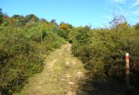
This stage leaves Izarra through an alleyway that heads in a north-westerly direction and, after passing through a gap, begins an ascent that is almost two kilometres long and has an incline of 200 m. The Trail crosses the mixed forest of beeches (Fagus sylvatica) and oaks (Quercus sp.) of Larrandoanda, which boasts a rich floral procession of junipers (Juniperus sp.), blackthorns (Prunus spinosa), hawthorns (Crataegus monogyna), etc. and offers a diverse array of textures and colours. You could say that this is the only ascent in a stage that is practically flat, with a gentle downward slope in the last third of the route.
Following the ascent, you leave the wooded area to reach meadowland strewn with hawthorn, holly (Ilex aquifolium) and blackthorn on El Alto del Corral, which gradually begins to offer views of the River Nervión valley. The trail soon crosses a gravel and dirt track, which you will have to take on the left and, after a roughly one kilometre walk among meadows and pastures, you should take a turn-off to the right, a dirt track that will take you immediately to some farm buildings.
At this point, the path leaves the track along a rutted trail that turns off on the left next to an animal enclosure. It continues along a pasture area, which is covered in part by heather and other shrubs, where there are also some beech woods, until you reach the source of the River Nervión’s canyon head. This area is extremely important for cattle, as it consists of extensive mountain pastures, where a large number of livestock feed in the summer and autumn.
Along this final stretch of the trail, you should keep an eye on the signposts, as there are many paths and dirt tracks that may confuse trekkers.
Continuing along the path and once you leave the canyon behind you, you cross a small river bed —always keeping to the track—, which the first stage of the River Nervión flows along. A little later on, it plunges into a waterfall some 300 m high along an eponymous canyon. At this point, the path leaves the province of Araba/Álava and continues through the lands of Burgos, crossing the Natural Monument of Mount Santiago, but without losing sight of the territory of Álava, which can be seen from different points along the route, specifically towards the Valley of Delica, which is irrigated by the River Nervión in its early stage.
The path immediately crosses a gravel track, next to a shelter, and should be taken on the right. Nevertheless, it is advisable to take a detour to the left momentarily along a track for a dozen metres to visit La Lobera del Monte Santiago, which has been restored as an informative and preservation element of ethnographic heritage. There are other wolf traps in the area that are in a state of ruin. They were built by our ancestors to capture the wolves that threatened their flocks of sheep. They provide evidence that these territories were filled with livestock in ancient times. This trap is unusual as it features two pits.
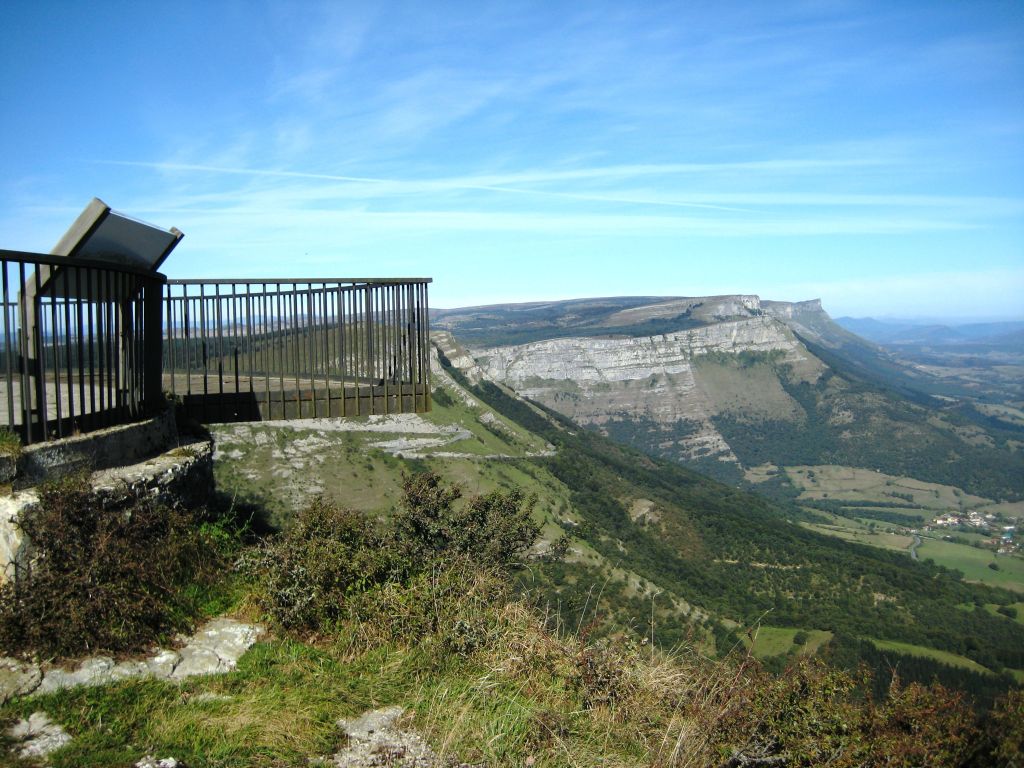
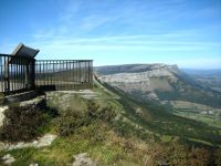
On returning to the path, you continue to the right along a gravel track reaching, after some 400 m, an impressive viewpoint over the Source of the River Nervión, from where you can see the Nervión canyon. This canyon was formed by the differential erosion between the clayey limestones and loams of the Cretaceous period. The canyon widens forming the Valley of Orduña, where the town of Orduña, among others, is situated. In the rainy season, you can contemplate, to the right of the viewpoint, the impressive waterfall on the River Nervión that plunges into the canyon below. Furthermore, it is very common to see different species of birds flying over the canyon’s rocky faces, where rock species such as the Golden Eagle (Aquila chrysaetos), the Eurasian Griffon (Gyps fulvus), the Peregrine Falcon (Falco peregrinus) and the red-billed chough (Pyrrhocorax pyrrhocorax), among others, frequently build their nests and roosting places.

From the viewpoint, the route continues in a north-westerly direction bordering the Nervión canyon along a cliff path. After some 2.5 km and a slight ascent at the end, you reach the viewpoint of Mount Santiago or “Rubén’s corner”, which offers an extensive view of the Valley of Orduña and belongs to the region of Arratia-Nervión.
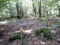
From this second viewpoint, the path continues along a gravel track, which, in a southerly direction, enters the beech grove of Santiago and, after a slight descent of 1.5 km, reaches the car park and the recreational area of Mount Santiago, the point of the main access. The “Senda del Pastoreo” continues across the car park although, before setting off, it is worth leaving the route momentarily and continuing another one hundred metres along the track to visit the “Casa del Monumento” or the Monument House, where you can discover the natural and cultural values that led to its designation as a Natural Monument Site. You can also visit the ruins of the Monastery of Santiago Langreriz and the “Fuente Santiago” nearby.
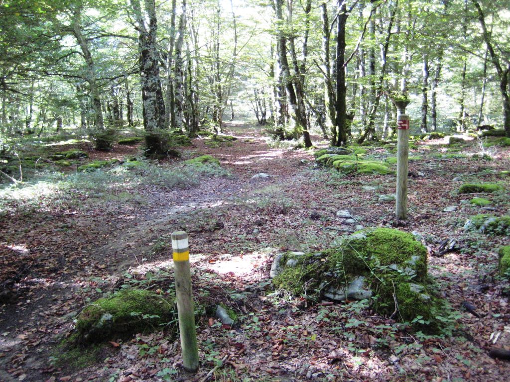
On returning to the path, from the car park, the trail continues along a forest path that crosses the Beech Grove of Santiago. You should pay attention to the signs to ensure that you do not lose your way as it is difficult to see the path underneath the canopy of trees, especially in areas where there are limestone pavements. This path terminates in a small car park located next to the road that accesses the Natural Monument and you should continue along it to the right for some 300 m. You should then take a path that begins on the left and continues along a land of sparse pastures covered with heather (Erica sp.), broom (Genista sp.) and specimens of hawthorn, blackthorn, oak (Quercus ilex), and especially of holly sharpened by cattle’s teeth, which comprise a unique sight.
The initial path, which begins with a slight rise, soon disappears and carries on by descending some five kilometres along a dirt track that offers interesting visits to the Valley of Villalba de Losa. In its descent towards Berberana, it crosses some clusters of oak and gall-oak (Quercus faginea), such as those of Malocalaña and Carrascal. This area is also important for livestock.
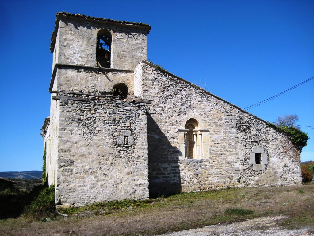
After crossing the town of Berberana in a northerly direction, you immediately cross the intermittent course of the River Omecillo via some stepping-stones. The path continues along a gravel track, which, after crossing a busy road, you should leave to go over the same river once again, passing very close to the town of Murita. Here you should take a farm road on the left, which crosses agricultural land and leads you to a rest area. After passing through it, you should turn left along a trail in poor condition that climbs as far as the end of the stage, in the town of Villalba de Losa, located on a hill from where you have fabulous views of the Valley of Villalba de Losa. This town is the birthplace of Juan de Garay, an illustrious personage who founded cities such as Buenos Aires.
For cyclists it is an accessible but awkward stage, as it mostly runs along paths and trails whose surfaces are very uneven which make cycling difficult, especially in the cliff path part, between both viewpoints.
Profile
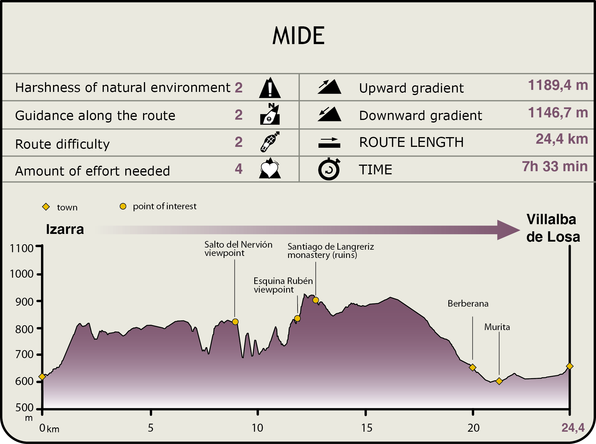
MIDE (Method for the Information of Excursions)
 Harshness of natural environment
- 1. The environment is not risk-free
- 2. There are more than one risk factors
- 3. There are various risk factors
- 4. There are quite a lot of risk factors
- 5. There are many risk factors
 Guidance along the route
- 1. Well defined trails and crossings
- 2. There is a clearly marked trail and signage
- 3. Requires the identification of geographic features and cardinal points
- 4. Requires off-path navigation
- 5. The trail is interrupted by obstacles that have to be gone around
 Route difficulty
- 1. Walking on a flat surface
- 2. Trails with different types of path
- 3. Walking on stepped paths or irregular terrain
- 4. The use of hands or jumping over the terrain is necessary
- 5. The use of hands is required to progress
 Amount of effort needed
- 1. Up to 1 hour of continuous walking
- 2. Between 1 and 3 hours of continuous walking
- 3. Between 3 and 6 hours of continuous walking
- 4. Between 6 and 10 hours of actual walking
- 5. More than 10 hours of continuous walking
Featured
Further information
SCI, SPA for Birds and the Natural Monument of Mount Santiago (Burgos)
The protected natural areas, Mount Santiago SCI and Mount Santiago SPA for Birds, which have the same boundaries (2.536,96 ha), and the Mount Santiago Natural Monument, which coincide in part (2.411 ha), are located at the north-eastern end of Burgos, right on the border with the Basque Country, in a transition area between Atlantic and Mediterranean Spain.
The Mount Santiago area is a space of enormous landscape, geological, geomorphological and floristic interest. It is a karstic development that forms a drop in the plateau over the River Nervión, featuring numerous caves and an impressive waterfall, the “Salto del Nervión”, which is over 300 m high. The source and gully of Mount Santiago are also noteworthy.
The plant cover in the area is extremely varied and has considerable specific wealth, boasting oak and gall-oak stands at medium and low heights and beech groves on karst and pine afforestation at the highest levels. This area houses one of the twelve “Important areas for Spanish reptile and amphibian fauna in Castilla y León (2002)".
Arkamo-Gibijo-Arrasta SCI
The Arkamo-Gibijo-Arrasta Site of Community Importance has a total surface area of 11.538 ha. It is a mountain range that runs in an east-westerly direction between the Valley of the River Baias and Burgos, where the lie of the land is pronounced and abrupt, interrupted by the existence of karstic flatlands in some areas.
As regards the fauna that can be found in the mountain range, worthy of mention is the Alpine newt (Mesotriton alpestris), the garden dormouse (Eliomys quercinus), the European pine martin (Martes martes), the European wildcat (Felis silvestris), the red deer (Cervus elaphus), the roe deer (Capreolus capreolus) and different bats.
With respect to the birdlife, the northern area of the SCI features rocky crests where different rock and mountain birds build their breeding grounds. In fact, the populations of some birds —the Griffon Vulture (Gyps fulvus), the Peregrine Falcon (Falco peregrinus), the Golden Eagle (Aquila chrysaetos), the Egyptian Eagle (Neophron percnopterus) and the Red-billed Chough (Pyrrhocorax pyrrhocorax)— are among the densest in the Basque Country. It is because of this that this area is included under the figure of the Special Protection Area for Birds (S.P.A.) Sierra Salvada, and of IBA (Important Bird Area) 33 La Losa-Orduña (Sierra Salvada).
Multimedia