- Home
- Rural Development
- Nature Trails
- Nature Trails
- Northeast Sector
Stage 1: Arantzazu - Arlaban
Description
Alto Deba
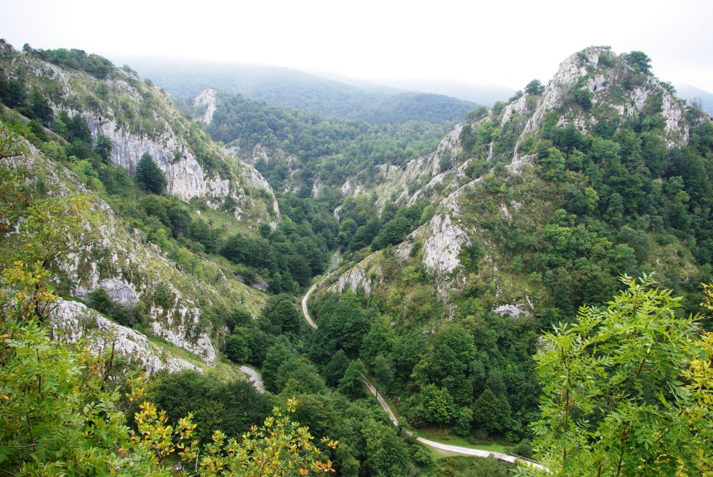
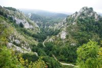
Departing from the sanctuary of Arantzazu, in this Stage, the trail covers the northern side of the hills of El Alto Deba, crossing extensive areas of beech and mixed woodland, as well as extremely beautiful karstic developments, which led to its declaration as the Aizkorri-Aratz Natural Park.
The “Senda del Pastoreo” begins at the sanctuary of Arantzazu and, following a circular route, ends in the same place. Approximately 1.5 km in a northerly direction from the sanctuary, you come to the “Shepherds School”, in the Gomiztegi Farmhouse, whose goal is to keep the ancient trade of shepherding alive, giving meaning to this Nature Trail whose purpose is to link the main shepherding areas in the region together.
The first stage runs entirely within the territory of the Aizkorri-Aratz Natural Park and of the Aizkorri-Aratz Site of Community Importance (SCI), whose areas overlap.
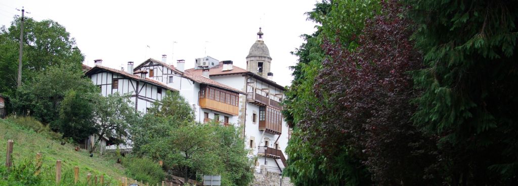
This Stage begins in the sanctuary of Arantzazu’s car park, where you can visit the Aizkorri-Aratz Park House and increase your knowledge of the Natural Park.
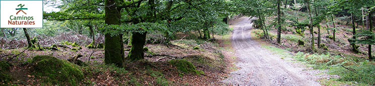
From the car park, through a gap in the protective walls, there are some steep steps, which then give way to a narrow path that descends through Zubia as far as the valley, where the Rivers Urkullu and Billotza converge. At this point, turning to the left, the trail joins a concrete lane that crosses the river and heads towards the River Billotza, to the town of Bellostegi, along a small limestone gorge. Before reaching the first houses, you have to take a path that branches off to the right, moving away from the river and entering the forest area. Some 300 m from the turning, you have to leave the trail and take a path that forks off to its left. At this point, a climb of some three kilometres begins as far as Artaso’s shacks or cabins. This route mainly runs between beeches (Fagus sylvatica), and some conifer plantations, mainly radiata pine (Pinus radiata).
At some points, the accumulation of water makes walking on the path uncomfortable because of the mud. When you reach the top, you will come to the braña or group of shacks of Artaso, where you can stop and rest from the climb while you contemplate the views of the valley. The path crosses the shacks and enters the beech wood once again.
From here, you descend the paths and trails that cross beech woods and conifer plantations for almost three kilometres until you come to another braña.
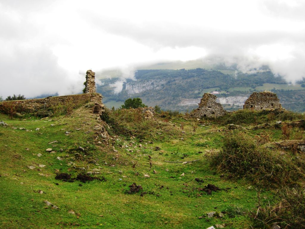
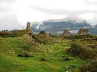
At this point, you can see some ruins, which are probably of huts or farmhouses. The path crosses the braña at the same height and continues into a pine plantation. Some 400 m later, you come to an area outfitted with tables for resting. The route then continues towards the left for some eight kilometres, entirely at the same level, between beech and pine trees, crossing the streams that flow along the northern side of the Sierra of Urquilla. From this point onwards, the trail continues in the same condition but is sloped for 1.5 km, after which you reach the Valley of Degurixa, which is an element of geological interest formed of a large karstic origin depression, with numerous dolines at the bottom. This depression is home to rich mountain pastures, the main reason for the location of some farm shacks and cabins.
In the sections that cross the beech wood, you will need to pay attention to the signposts and marks as there are numerous intersections and you can easily lose your way and miss the correct route.
From Degurixa, the trail continues with a climb of some 200 m among pastures, brushwood and rocky outcrops as far as El Alto de Otxo-Arrate, where you have to turn to the left and follow a trail that runs along the top. To the north of this point, two elements of geological interest stand out; the “Slope of Kurutzebarri”, which is a karstic development with sloping morphology, and the ”Bolívar coluvial blocks”, formed from landslides from Kurutzebarri.
From here onwards, except for the last two kilometres, the rest of the stage is downwards. In this way, you follow the trail to Aurdi, which runs along the ridge of the Sierra of Elgea. On reaching the end of the rise, at a fork, you take the trail to the left and immediately turn right, descending in the direction of a gas pipeline. You cross a first trail and, at the second crossing, you leave the layout of the gas pipeline behind you. After taking a forest path on the right which descends among beech and oak trees, you cross another trail once again, which is the one the route takes until you almost reach Etzustegui. You leave the track, and continue along a path until it enters a meadow plot, descending close to a Scots pine grove (Pinus sylvestris) and reaching a farmhouse. The Sierra of Elgea is unique in comparison with the rest of the layout of the “Senda del Pastoreo” because of the acidic nature of its substrate. This acidity in the terrain causes the presence of siliceous species such as the English oak (Quercus robur), which forms a mixed stand along with beech, blueberry (Vaccinium myrtillus) and several species of heather, such as common heather (Calluna vulgaris) and bell heather (Erica cinerea), which make up the bushy covering proper to Atlantic forests with acidic soils.
From the car park, you take a secondary track that accesses the main road and climbs up to the Arlaban pass. At the crossroads, you can see an image of Nuestra Señora de Dorleta, the patron saint of cyclists.
Turning to the right, you carry on along the road for some 200 m, when you then take a turning to the left, next to a lay-by, along a very narrow path that descends between Spanish chestnuts (Castanea sativa) and common hazels (Corylus avellana), as far as the chapel of Nuestra Señora de Dorleta. The path passes in front of its main façade and joins the road that accesses it.
At this point, you can walk along the branch that links up to the town of Leintz-Gatzaga, taking a turning to the right next to a bench, along a footpath. Leintz-Gatzaga features a historic site that is worth visiting.
Whether you visit the town or not, the trail continues along the road for a few metres, until it crosses the River Deba, immediately taking the path on the left-hand side. This lane climbs sharply between farms until it joins the trail of the old railway line that leads to the road that heads to the Arlaban pass. In this last stage, you can see some outstanding examples of coppiced beech trees, which are the result of the use that was made of beeches in the past in some areas of the Basque Country. On reaching this road, cross over and take a path that runs parallel to it as far as Arlaban, where the first stage ends.
This stage is unsuitable for cycling, especially the descent via steps from the sanctuary of Arantzazu; some sections of the path inside the beech grove have very uneven and steep boggy surfaces; some passages through limestone outcrops are very uneven, as is the descent down the path as far as the chapel of Nuestra Señora de Dorleta.
Profile
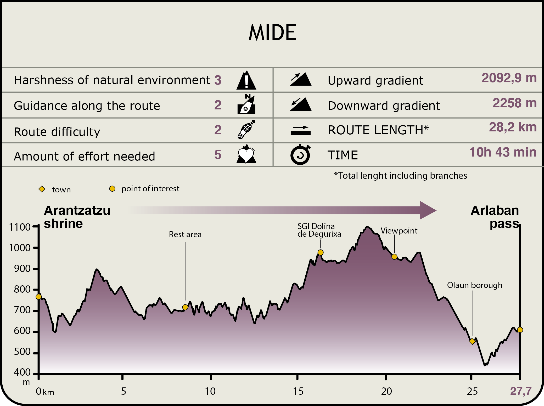
MIDE (Method for the Information of Excursions)
 Harshness of natural environment
- 1. The environment is not risk-free
- 2. There are more than one risk factors
- 3. There are various risk factors
- 4. There are quite a lot of risk factors
- 5. There are many risk factors
 Guidance along the route
- 1. Well defined trails and crossings
- 2. There is a clearly marked trail and signage
- 3. Requires the identification of geographic features and cardinal points
- 4. Requires off-path navigation
- 5. The trail is interrupted by obstacles that have to be gone around
 Route difficulty
- 1. Walking on a flat surface
- 2. Trails with different types of path
- 3. Walking on stepped paths or irregular terrain
- 4. The use of hands or jumping over the terrain is necessary
- 5. The use of hands is required to progress
 Amount of effort needed
- 1. Up to 1 hour of continuous walking
- 2. Between 1 and 3 hours of continuous walking
- 3. Between 3 and 6 hours of continuous walking
- 4. Between 6 and 10 hours of actual walking
- 5. More than 10 hours of continuous walking
Featured
Further information
Shepherds’ School
The Gomiztegi farmhouse was bought by a group of Franciscan monks in 1950. They started out with a small number of livestock, and gradually expanded their flock, including sheep, and refurbished their facilities. In this way, a dairy based on state-of-the-art techniques was created and a productive, rich kitchen garden was developed. The fruit of this effort has garnered the award for the best flock of sheep several times. In response to these results, in 1997, the Shepherds’ School was created, whose main mission is to train new professionals who are able to work as shepherds.
There are five monks in charge of running the school, and their teaching, which is combined with religious duties, is mainly geared towards sheep livestock. The students who go to the school stay there for six months, during which time they prepare themselves in theoretical and practical areas. The school receives pupils from all corners of the world, mostly shepherds’ children, who wish to carry on with the trade.
You can visit the facility on your route and watch the cheese manufacturing process, which boasts the designation of origin of Idiazabal, and taste the Shepherd’s cheese or watch shepherd dog shows.
Aizkorri-Aratz Natural Park and SCI
The Aizkorri-Aratz area separates the historic territories of Araba/Álava and Gipuzkoa, and forms one of the main mountainous regions of the Basque country. The Natural Park measures 15.919,24 ha, while the Site of Community Importance (SCI) covers 6.778,84 ha, whose territorial areas overlap in part.
The landscape is abrupt, with outstanding, complex limestone reliefs and widespread karstic phenomena, which give rise to formations as diverse as crests, ledges and crags, deep ravines, depressions and fields of limestone pavements, shaping a landscape of great aesthetic and ecological value.
This extensive mountainous space features an important variety of woodland, with noteworthy stretches of autochthonous forests of limestone and acidophilus beech trees and Pyrenean and gall oaks, as well as oak groves. It also boasts mountain meadows, heaths, streams and humid enclaves of enormous botanical interest such as the fens of Arbarrain (Altzaina).
The land is mainly used for forestry and livestock, in addition to recreational purposes (mountaineering and trekking). This is one of the most important grazing areas for “latxa” sheep, which are joined, although to a lesser extent, by cattle and horses. Numerous huts or "saroiak" relating to this use can be found in the surrounding area. The landscape also features the Aizkorri Aratz Natural Park House (Parketxe Arantzazu), which offers activities based on the different aspects and characteristics of the Natural Park.
Multimedia