- Home
- Rural Development
- Nature Trails
- Nature Trails
- Northeast Sector
- de las Muntanyes de Prades
Muntanyes de Prades Nature Trail
Description
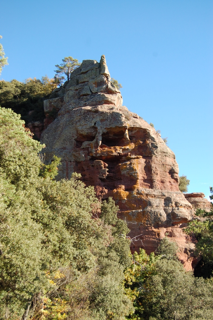
Muntanyes de Prades, natural windows onto the landscape
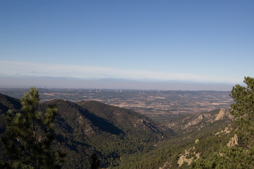
This path discovers the spectacular areas surrounding the charming municipality of Prades, which runs across Mediterranean forests featuring a diverse array of species and conservation levels, and allows trekkers to enjoy the beautiful views of the vicinity, from where, on clear days, you can see the Mediterranean sea and the Pyrenees.
This municipality is also known as Vila Vermella (Red Town) because of the reddish sand stone that characterises some of the emblematic buildings in the town. The path’s main itinerary is 27 km long and has 3 alternative braches: the Path of La Serra del Bosc, measuring a little under 4 km; the Path dels Pics, with a route of approximately 2.5 km and the Path of Vell de Montblanc with a length of some 2 km.
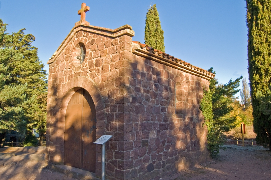
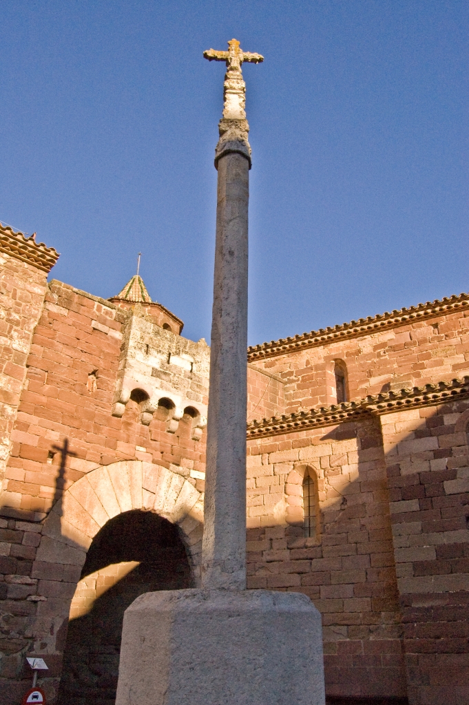
The route begins at Carrer de Sant Roc, where you can see a signpost that marks the starting-point, which is very close to La creu de terme i el portal which forms part of the town of Prades’ architectonic site. Still in the town, the path leaves on its right the chapel of Sant Antoni, which was rebuilt between 1958 and 1959. This chapel exalts an image of Sant Antoni de Pàdua in its interior.
The Main Path of Las Muntanyes de Prades
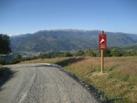
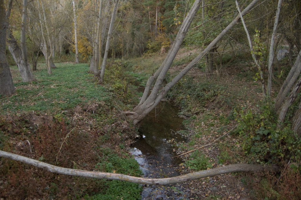
On leaving Prades, a bridge over el Riu (river) del Pla is crossed and the route passes near San Antoni chapel. The Trail begins an ascension for the next kilometers. The first section of the Trail is shared with motor vehicles so special care must be taken.
Trekkers continue along a trail that leads to the chapel of Sant Roc, the smallest of the chapels in Prades, which lends its name to the hill where it is located. You will leave to your left the connection with the initial point of the Camí dels Pics branch (see the description below).
From the chapel of Sant Roc, the path turns into a trail for a few metres, to then turn once again into the main path until it reaches the recreational area of the Mare de Deu de l'Abellera, located a few metres from the Font d l'Angel and from the chapel of La Mare de Deu de l'Abellera itself. Trekkers will continue along a narrow, shady trail among hills where Holm oaks prevail, which will protect them from the sun on hot summer days.

Having passed the kilometre two milestone, the path widens, running along the mountainside, with a gentle upward slope. On the right, travellers will enjoy unbeatable views of the municipality of Capafonts. In this section, you walk through hardwood forests and as you progress, pines become more frequent.
At the end of this climb, the path returns to its regular width and, after a few metres, trekkers leave on their right the initial point of the Camí de la Serra del Bosc or of the Quatre Termes branch (see description below).
Travellers turn to the left and continue along a very wide path, to then turn to the left once again, covering some 200 m along a path that emerges into a wider path. Trekkers can check that they have chosen the correct path as kilometre 8 is just a few metres after you take this path
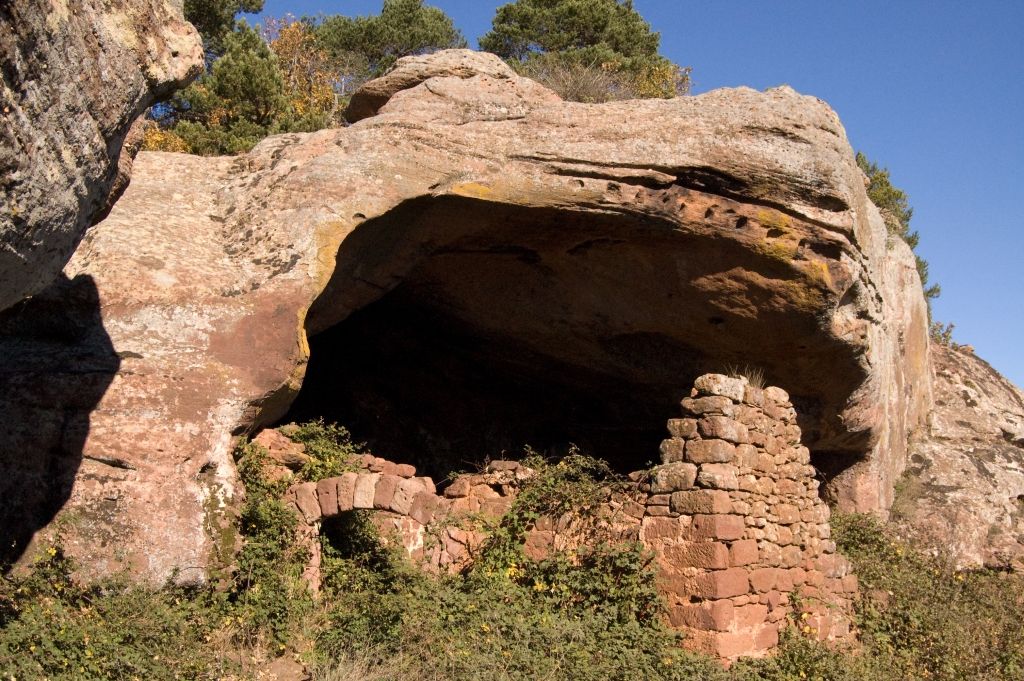
Once again on the main path, to the left, travellers will come to a branch that leads towards the rock of Gringol, which begins with a very wide path for 75 m to then turn to the left along a trail until they reach the rock of Gringol and the ice well in the vicinity.
Travellers should return from this branch, retracing their steps, to continue along the trail in the direction of El Tossal de la Baltasana, but beforehand, they will discover the turn-off towards Cova de Pere, whose ruins are still preserved today.

In the vicinity of kilometre 9, the path turns to the left to reach the crossroads that accesses El Tossal de la Baltasana in a little under 250 m. It is a 500 m branch with a good surface and a continuous climb.
Once you have climbed down to the junction at the beginning of the branch, you continue in a westerly direction, beginning a descent where you will come to the Font de la mina de l’Obis, where, in the past, barite was extracted. This mineral is of the sulphate type and is used to produce hydrogen peroxide, the manufacture of white pigments and paints and in the cork industry. Trekkers continue descending as far as an esplanade with a water reservoir, where there are many excellent views and a path junction, which you should ignore and continue straight ahead. Walking among Scots pine forests (Pinus sylvestris) and oak groves, you descend as far as the crossroads with the T-700 highway where you have to walk a few metres parallel to the road along a track especially designated for this purpose before crossing very carefully.

The path continues descending gently. A little later on, the path turns abruptly to the right to then, after a small riverside forest, enter the forest mass once again beginning a 2 km section; firstly with a slight incline, to then descend as far as the River Prades, leaving behind chestnut stands (Castanea sativa) that bear witness to the traditional cultivation of this species in the past
Travellers will leave the River Prades among mixed forests and gets to the the Waste Water Treatment Plant of Prades, where the path turns abruptly to the right as far as the T-701 highway, which a part runs parallel to until you carefully cross it.
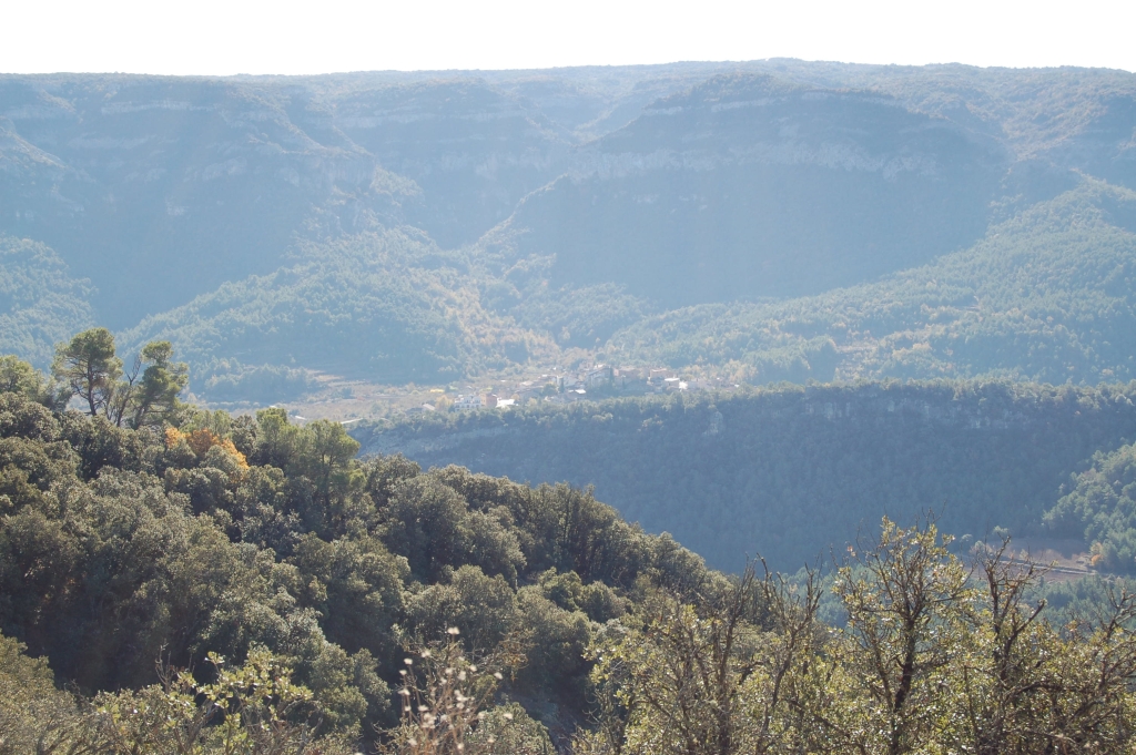
At this point, the ascent begins up to the view point of Pla de la Guardia. The first section is completed along a very wide path to then, after passing kilometre 20, take a path on the right that zigzags up a steep slope until you reach the summit. You turn leftwards along a path that is difficult to pinpoint, always parallel to the cliff in a northerly direction, until you reach the first vantage point of Pla de la Guardia where you will enjoy some unbeatable views of the Natural Park of the Serra de Montsant. After kilometre 21, you continue parallel to the cliff in an easterly direction until you reach the second viewpoint of Pla de la Guardia, where you can rest at some tables and benches especially set aside for this purpose while you enjoy a spectacular view of Prades.
The trail turn to the right to take a very wide, well- surfaced path where you can walk among small-size Holm oaks and perhaps some flocks of sheep, reaching, in this way, kilometre 22 of the route. A section that is easy to descend then begins where the hardwood mountains become thicker. In a little over 300 m, after passing the milestone for kilometre 23, a part begins that is shared with motor vehicles; hence, you should carefully walk on the left. After a little under a kilometre, you will come to an old limekiln whose structure is partly preserved.
You continue along the path as far as the T-704 highway where the shared section ends and you discover the Font Cap Pla. After turning leftwards, you carry on along a section parallel to the road along a track designated for this purpose.
Now heading in the direction of Prades, you will come to the Perelloner del Cisterer, a pear tree (Pyrus spinosa) catalogued as a monumental tree due to its enormous size, which, in springtime, blooms spectacularly and is covered with different shades of white.
The first houses in Prades begin at Carrer de Reus with its eponymous Creu (cross), as here trekkers pass over the Romanesque bridge, until they reach the road junction (T-701 with T-704), which they should cross carefully. Now, in the middle of the town of Prades, you take the Carrer dell Aigua and, at the end, you turn rightwards along Carrer Major until you reach Plaza Major.
Bran of la Serra del Bosc (o del's Quatre Termes)

The branch begins between kilometres 6 and 7 of the Nature Trail at the end of a short, stony climb.
Barely 300 m from the beginning of the branch, you come to the Pou de Gel del Dineral, a circular section ice well used in the past to collect ice and then transport it to villages for food preservation. Trekkers walk another 300 m along the main path and take a track on the right. This track heads in an easterly direction and crosses the main path, the point when a descent begins where the forest mass becomes thicker. The track, which in some parts is stony, allows you to see splendid views through natural windows formed by a lack of vegetation.
A large part of the section coincides with the GR-171 highway; hence, its signposting will serve as support for following the route correctly. At one point, it leaves the track to take a wider path, which, in a little over 100 m, turns rightwards along a very steep trail with black pines (Pinus nigra) and enormous Scots pines.
The climb ends at the Mola d’Estat, which offers privileged views as a reward for the effort made. The path then continues for a few metres along the trail to then take a very wide path, which unmistakably heads towards the Taula dels Quatre Batlles (the four mayors’ table), which marks the point where the four municipalities of Mont-Ral, Prades, Vimbodà and Rojals converge and where the mayors of these four municipalities used to meet to deal with common problems and issues, such as, for example, tree felling in the mountains shared by the municipalities.
The Path of El Pics
The branch of the Camà dels Pics begins at the chapel of Sant Roc, where you can find a water reservoir for putting out fires by climbing a very wide track. During the itinerary, you come to a bench where you can enjoy the beautiful views of Prades. The path continues to climb among mixed hardwood and conifer forests, passing through a cemented section where the slope increases. Meanwhile, pines gradually gain ground over hardwoods, until, a little later, you come to kilometre 2 at the end of the branch, joining, at this point, the main path of the Muntanyes de Prades Nature Trail.
Branch Vell de Montblanc
The branch of Camà Vell de Montblanc begins at the Creu de Montblanc along a road with the same name as the path. You leave the town of Prades among hazelnut crops and houses and enter the forest mass immediately coming to a turn-off indicating the location of a recreational area where you can rest and which has tables and benches for this purpose. You continue to climb with a Scots pine grove on your right and Pyrenean oak (Quercus pyrenaica) stands on your left. The latter trees are highly appreciated in this area and in the vicinity of El Tossal de la Baltasana, as they are the best representations of this species in Catalonia within the sparse representation of the Pyrenean oak in this community.
In a little under 2 km, the branch of the Path of Vell de Montblanc comes to an end, converging with the branch of the Path of Els Pics.
Sites of interest
Map
Puntos de Interés
Información
Profile
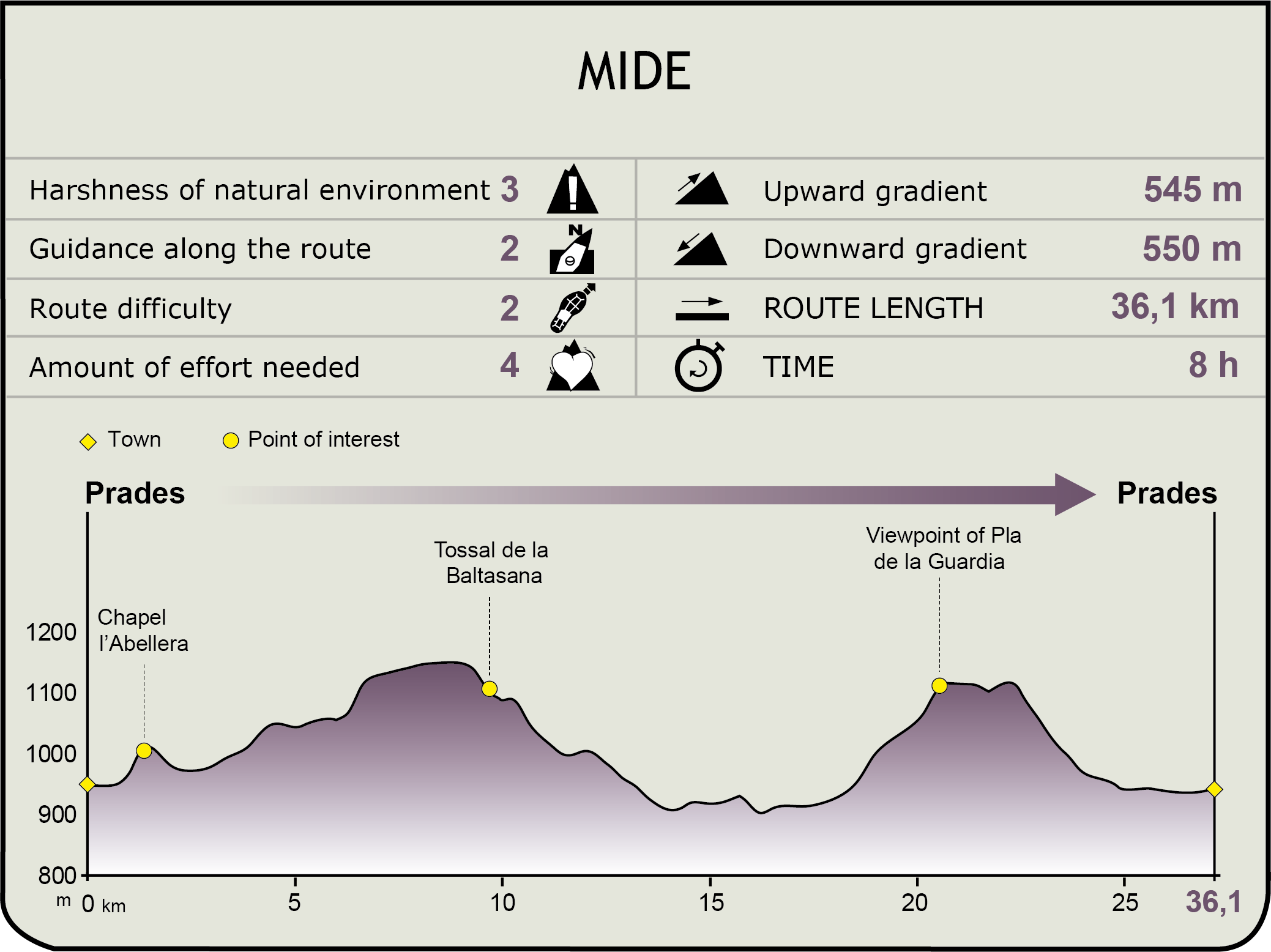
MIDE (Method for the Information of Excursions)
 Harshness of natural environment
- 1. The environment is not risk-free
- 2. There are more than one risk factors
- 3. There are various risk factors
- 4. There are quite a lot of risk factors
- 5. There are many risk factors
 Guidance along the route
- 1. Well defined trails and crossings
- 2. There is a clearly marked trail and signage
- 3. Requires the identification of geographic features and cardinal points
- 4. Requires off-path navigation
- 5. The trail is interrupted by obstacles that have to be gone around
 Route difficulty
- 1. Walking on a flat surface
- 2. Trails with different types of path
- 3. Walking on stepped paths or irregular terrain
- 4. The use of hands or jumping over the terrain is necessary
- 5. The use of hands is required to progress
 Amount of effort needed
- 1. Up to 1 hour of continuous walking
- 2. Between 1 and 3 hours of continuous walking
- 3. Between 3 and 6 hours of continuous walking
- 4. Between 6 and 10 hours of actual walking
- 5. More than 10 hours of continuous walking
Featured
Further information
Ermita de L’Abellera (Prades)
The current shrine of the Mare de L´Abellera is believed to date back to 1570 and flaunts an aisle that is thirteen metres long and six metres wide. The image of the virgin, which dates back to 1940 and is a true copy of its predecessor, was crowned by the Archbishop of Tarragona in 1956 and this crown is formed of a Queen bee and fifty silver bees guarding her, in addition to the coat-of-arms of the municipality of Prades.
The chapel has undergone numerous changes and is located in a cave that served as shelter for shepherds and people from the area in adverse weather conditions, and was even used as a settlement. Queen Margarida de Prades may have retired to the original chapel and in 1484 it was inhabited by Friar Bernat Boïl (the first Apostolic Vicar of the Indies who went on the second voyage to America with Christopher Columbus).
The image of the Mare de L´Abellera is said to have been found by a shepherd who was going to get honey from a specific Holm oak. The shepherd took the image home twice and the virgin appeared again in the Holm oak where he had found it. It is because of this and because there were said to be hives of bees with their honeycombs inside it that the image is the patron saint of the Catalan beekeepers.
Tossal de la Baltasana
This is the highest summit of the Mountain of Prades, measuring 1,201.9 m above sea level. From this point, you have an extensive view that begins at the Pyrenees and takes you as far as the Mediterranean sea. This summit is 2 km in a straight line from Prades and is also known as La Torre. It can also be accessed from the GR-171 highway.
Multimedia