La Muga Nature Trail
Description
From the Mediterranean to the Pyrenees
The course of the River La Muga guides the Nature Trail through different natural spaces in the province of Gerona, between the the Mediterranean Sea and the region of l’Alt Empordà , following a route that draws you near to the life of this region and its close link to the river, in a border territory where culture and biodiversity come together.
La Muga Nature Trail follows the course of the River Muga and links together different natural spaces in Gerona, such as the Natural Interest Space (Spanish acronym: EIN) of l'Alta Garrotxa, the EIN of Les Salines, the EIN of Penyasegats de La Muga and Els Aiguamolls de l'Empordà Natural Park, discovering on its way different river-related habitats, ranging from riverbank woodland to alluvial plains, linking, in this way, the Mediterranean Sea to the Pyrenees.
For approximately 40 km, the Nature Trail passes through the municipalities of Castelló d'Empúries-Empuriabrava, Peralada, Cabanes, Pont de Molins, Boadella i les Escaules, Terrades and Sant Llorenç de la Muga, along a route that offers activities such as fishing, bicycle tourism and trekking.
The landscape in the region where La Muga flows is closely related to the river. Flour mills, ice wells, irrigated land and vegetable gardens are located along its course, a genuine traditional and agricultural culture which, obviously, links the landscape and the territory to the crossing and border area of El Alt Empordà.
Moreover, La Muga Nature Trail links up with two other circuits, namely the Itinerànnia path network, the GR-11, the GR-2, the GR-92, mountain bike routes (Spanish acronym: BTT) in the centre of the Salines- Bassegoda area and El Camino de Santiago or St. James’ Way.
The Trail begins at Empuriabrava, on a beach that is located next to a building called “La Colmena” where you can see the mouth of the River Muga and the whole of the Gulf of Roses. On the horizon, observers will be able to recognize the rough landscape of the Cabo de Creus, a spot of scenic and cultural interest. During the first three kilometres of the route, trail users will be able to enjoy some natural marshlands that give shelter to a diverse array of bird species in Els Aiguamolls de L’Empordà Natural Park.
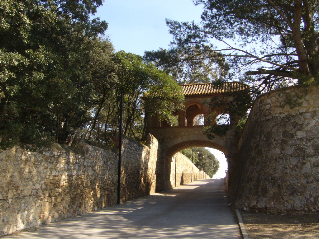
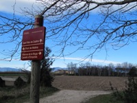
On this first leg, the Trail has a red tarmac finish, which is greatly appreciated by urban cyclists. After five kilometres of placid progress, you will reach the town of Castellò d’Empúries, in whose streets and squares you will recognise the passing of the last 600 years of history. It is a good idea to visit the old wall and the gate of La Gallarda, as well as the cathedral and La Farinera eco-museum. Leaving the town in the direction of Vilanova de la Muga, you will come to the connection with the Nature Trail, which has informational panels indicating your position and the route.

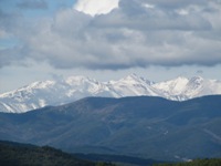
This is the beginning of a route on level ground that runs among farmland until it reaches Vilanova. Following the road that comes from the town, towards the left, you cross the River Muga via a concrete ford which in flood season (spring and autumn) is usually inaccessible. Once you have crossed the river, you continue along the road towards the right, along the right bank of the river. Some 500 m on, the Trail leaves the road following the river and plunges once again into crop and fruit tree fields. If the day is clear and sunny, while you make your way across the cereal fields, you can see, in the background, the mountain of El Canigó, the first tall summit of the Pyrenees, although strictly speaking it is in French territory.
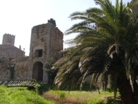
After passing some farms, the Trail passes under the Figueras to Porbou railway line and under a road that follows the same route. Some 200 m further on, you come to a resting area. You are now in the municipality of Peralada, whose town is well-known for the staging of a music festival in the city’s castle and the production of wines and cavas. Even though it is rather a long way from the Trail, it is worth visiting Peralada and strolling through its streets. Continuing the route along the river mound, among reedbeds, you once again cross the road that links Peralada to Vilabertrán and Figueres, under a bridge.
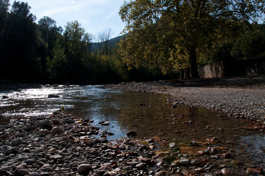
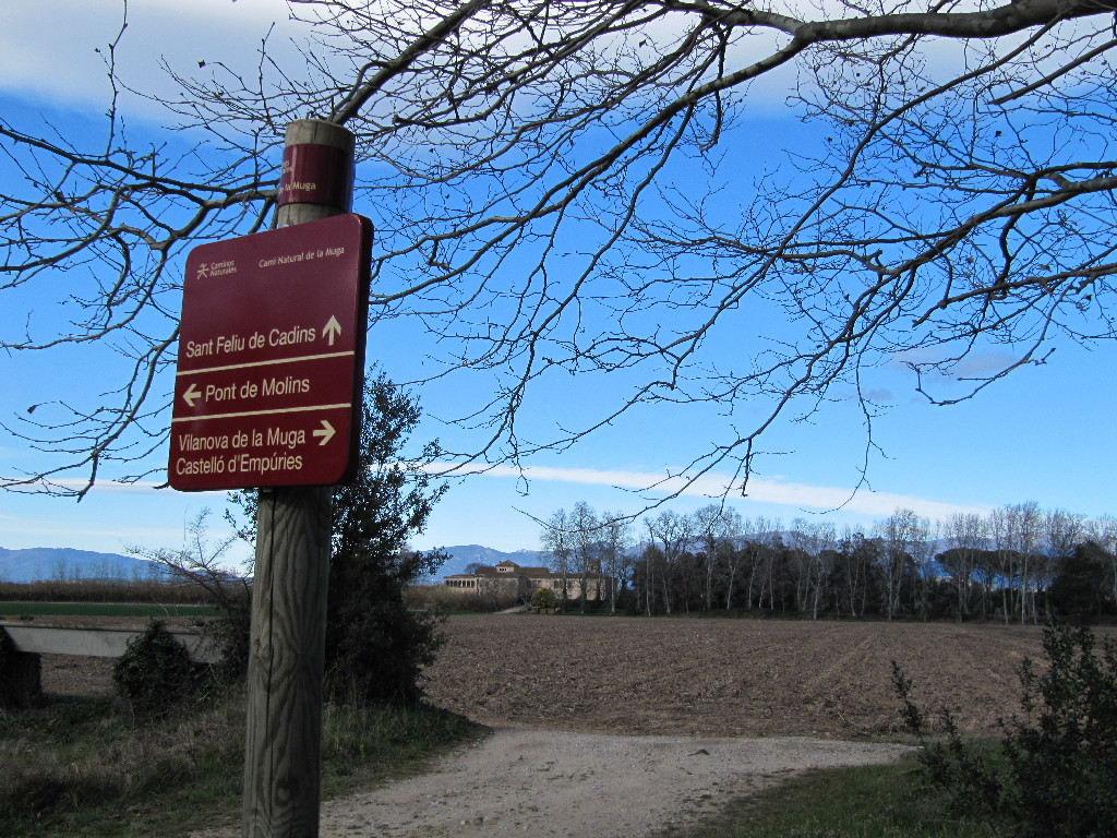
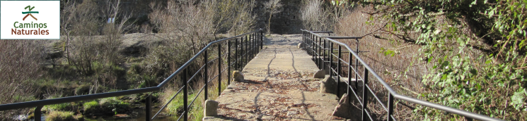
Some 500 m further on, the Trail runs across a riverbank wood area. From there onwards, and as long as you walk in silence, you will be able to see an otter (Lutra lutra) going in and out of the river. You now reach the trickiest and most hazardous part of the route, as you have to cross the river via the Cabanes to Vilabertrán and Figueres road bridge to continue the Trail along the left bank of the river. Once you have crossed over, continue your trek by keeping to the river that takes you upstream towards the mountains. When the path joins the irrigation canal, you will spot the monastery of Sant Feliu de Cadins, currently used as a straw loft in the country house of Sant Feliu.
Continue upstream and after passing a couple of forks, indicated by the Trail signposts, you pass under the AP-7 motorway that goes to France.

The Trail widens considerably because it is a passing area for trucks that transport material from a nearby quarry. Some two kilometres further on, you turn left to walk alongside the river again and reach Pont de Molins. You access the town via some wooden steps. Cross the river over the road bridge and, on the right-hand side, you will get back to the Trail again where you can see in the distance a viaduct for the AVE train. Before passing under this immense infrastructure, you will come to an information panel and the first and best preserved lime kilns you will find on the route. Two kilometres further on, the Trail turns right changing into a delightful path. Through holm oaks (Quercus ilex) and typical riverside trees such as alders (Alnus glutinosa) and poplars (Populus sp.), you can appreciate the large amount of plant species and, if you are lucky, you’ll be able to see an otter.
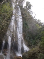
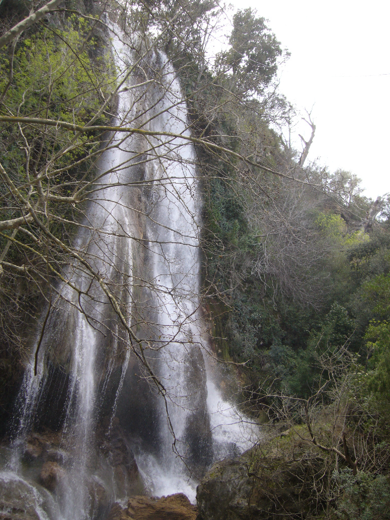
The change in the scenery towards the mountains is obvious. You will come to a small wind in the path but carry on with your pleasant walk until you come to a walkway over the river that will take you to an old flour mill, of which there are many on this leg of the route. This is a good time to rest and contemplate the river water flowing over small waterfalls. Following the route, the Trail crosses the Boadella road and, for three kilometres, it passes through a riverside wood and diverse estates where olive trees, grapevines and vegetable gardens grow. In the background, you can see the district of Les Escaules, with its noteworthy mediaeval tower and a waterfall, which in the rainy season becomes a magnificent sight.
Very close to the waterfall known as La Caula, you will come to an ice well (Pou de glaç), the best preserved in the area. In these holes, generally found in rock, ice was formed and preserved which was then used in houses or sold in the city.
Follow the route upstream passing by a small dam and the Molino de las Pulgas, an old flour mill that is currently privately owned. Following the mill canal, the Trail passes over a concrete walkway and, once you have climbed down some steel steps, it continues among poplars and alder trees as far as the mill water intake. Two kilometres further on, you come to Boadella d’Empordà, a small town which is very pleasant to stroll around, rest, eat and chat with the inhabitants.
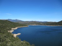
The Trail passes alongside the schools and the town hall and heads uphill in search of the Terrades road. After crossing it, the Trail descends seeking the river once again. Old cobblestones remind you that the path you are treading on was trod by others a long time ago. You cross the river via an old stone bridge and you will come to a resting area among London plane trees (Platanus x. hispanica). The Trail moves away from the river in search of the Boadella reservoir dam road. Following the dam road for some two kilometres, you now have to cope with the ascent up to the dam viewpoint.
From this point onwards and for some five kilometres, the Trail becomes increasingly more difficult, although the landscape and the environment are worth this small effort. At the top of a hillock, you can see the Chapel of Santa Magdalena de Terrades. Strawberry trees (Arbutus unedo) and heather (Erica sp.) reveal the importance of the Mediterranean forest in the whole of this area. On your route, you can see the reservoir and the remains of old buildings jutting out of the water in the low-water season. After descending via a concrete ramp, you access the head of the reservoir and once the valley widens, you will see the town of Sant Llorenç de la Muga, the end of your trek. An ideal place for walking, enjoying the river and a well-deserved rest.
Sites of interest
Profile
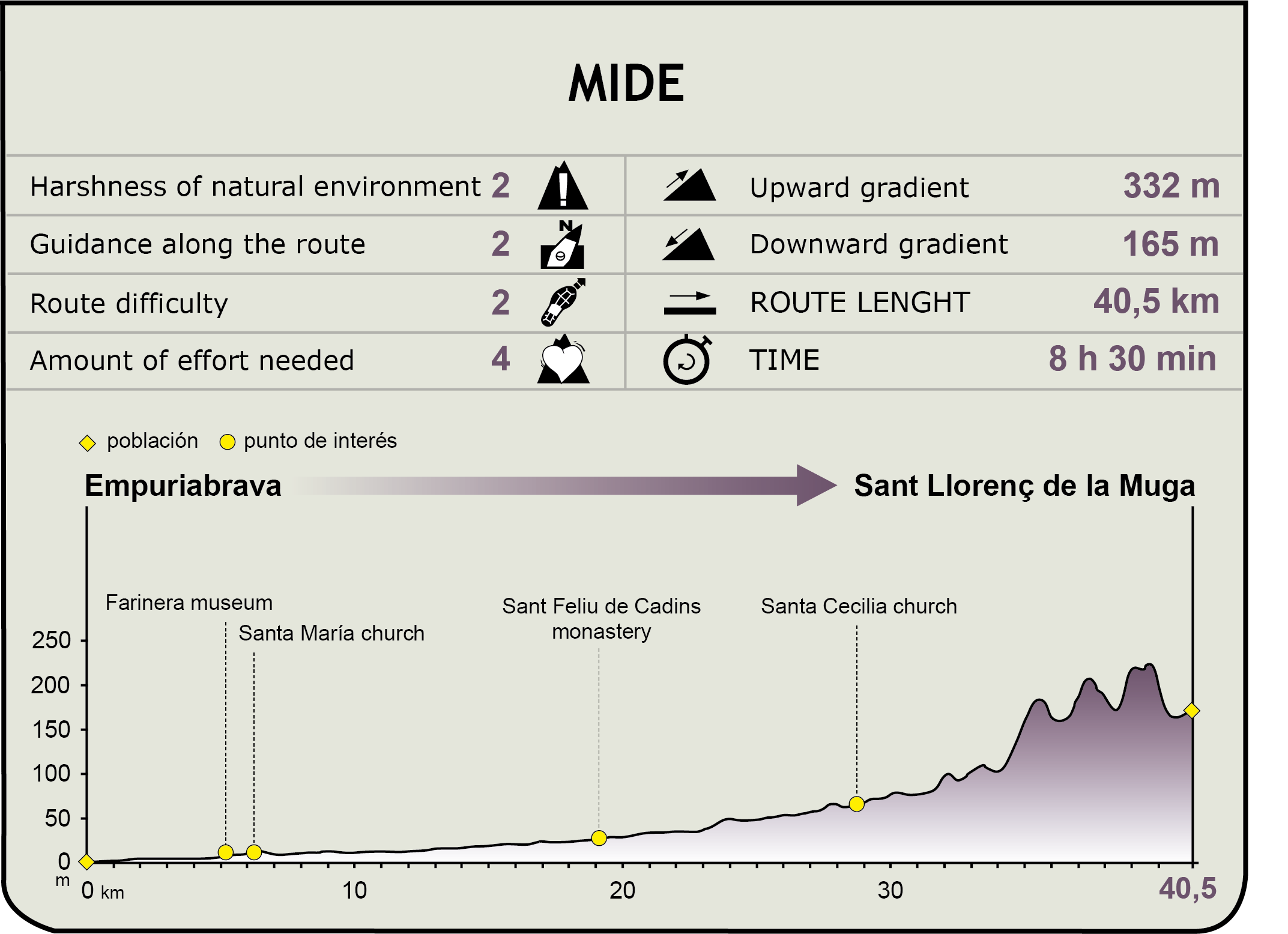
MIDE (Method for the Information of Excursions)
 Harshness of natural environment
- 1. The environment is not risk-free
- 2. There are more than one risk factors
- 3. There are various risk factors
- 4. There are quite a lot of risk factors
- 5. There are many risk factors
 Guidance along the route
- 1. Well defined trails and crossings
- 2. There is a clearly marked trail and signage
- 3. Requires the identification of geographic features and cardinal points
- 4. Requires off-path navigation
- 5. The trail is interrupted by obstacles that have to be gone around
 Route difficulty
- 1. Walking on a flat surface
- 2. Trails with different types of path
- 3. Walking on stepped paths or irregular terrain
- 4. The use of hands or jumping over the terrain is necessary
- 5. The use of hands is required to progress
 Amount of effort needed
- 1. Up to 1 hour of continuous walking
- 2. Between 1 and 3 hours of continuous walking
- 3. Between 3 and 6 hours of continuous walking
- 4. Between 6 and 10 hours of actual walking
- 5. More than 10 hours of continuous walking
Featured
Further information
La Muga, a border river
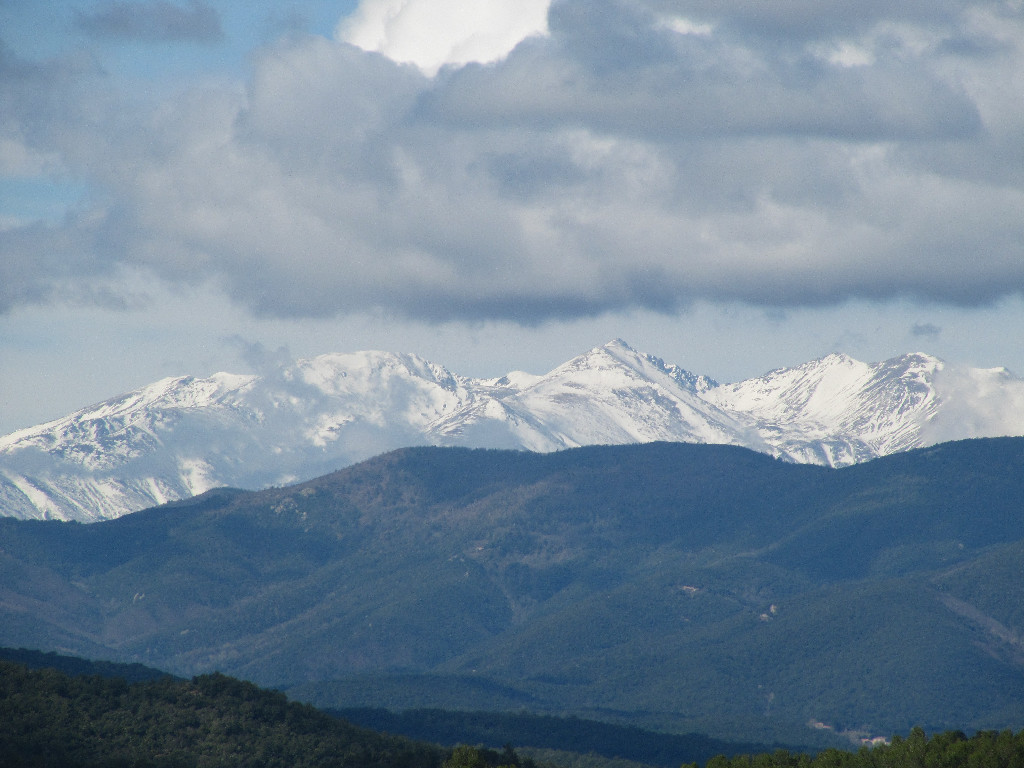
The name Muga means border: the border between two states, the border between two counties and the border between two regions. The river is born under the plain of La Muga (at an altitude of 1,186 m) and, from the Hostel of La Muga, it serves as the French-Spanish borderline for some 5.5 km. La Muga enters El Empordà through the municipality of Albanyà and receives rainwaters mainly from El Roc de Frausa, the Sierra de Les Salines and the Sierra de l’Albera, in the east Pyrenees. In its first section, it is an ideal place for river fishing in some of its countless gorges.
Close to Darnius, you will find the Boadella reservoir. The dam was built in 1969 and has an altitude of 60 m from the reservoir bed. It holds 62 hm³ of water that irrigates 10,000 ha of the fertile plain of El Empordà. Before the reservoir was built, the plain of El Empordà was frequently flooded. These floods are known as Mugades.
La Muga has different tributaries. Close to Peralada, it receives the Llobregat d'Empordà (and indirectly the Orlina), which increases its flow; and after Vilanova de la Muga, the River Manol. After travelling 58 kilometres, it flows into the Gulf of Roses in the municipality of Castelló d'Empúries, and forms a natural border between Els Aiguamolls de l'Empordà and Empuriabrava. The final stretch of the river is fully channelled.
In the Middle Ages, the course of La Muga was diverted in order to dry the ponds of Castelló d'Empúries, Pau and Palau-Saverdera, making the river flow into the current flat land of La Muga, between Empuriabrava and Els Aiguamolls de l'Empordà. Further to the north, you can still see the old course of the river, called the River Grau, to the south of Santa Margarida, in Roses.
L´Alta Garrotxa
L’Alta Garrotxa is a relatively isolated natural area with enormous biological richness that makes it the most important space in the east Pre-Pyrenees, to the extent that it has been declared a Natural Interest Site, a Special Protection Area for Birds (Spanish acronym: ZEPA), and a Site of Community Importance (SCI) and Special Area of Conservation (SCA) within Red Natura 2000.
The relief of the landscape is abrupt, comprising deep valleys surrounded by crags and rocky faces, which lends its name to the spot (garrotxes, rough lands). The forest cover is dominated by holm-oak plantations (Quercus ilex) and oak stands (Quercus robur). Furthermore, this extensive area of land (32,865 ha) has an important cultural heritage, including archaeological sites, country houses, chapels and villages.
Multimedia