
- Home
- Rural Development
- Nature Trails
- Nature Trails
- Northeast Sector
- Matarranya Algars
Stage 13. Arnes - Beceite
Description
From the River Algars to the River Ulldemó along the ravine of La Tremolosa
This stage leaves the River Algars behind to follow the ravine of La Tremolosa in search of the valley of Ulldemó, a small river that flows into the Matarraña in the village of Beceite, the final point of the stage. In this village the route reconnects with Stage 1 of the trail, thus completing the circular formation that has taken the traveller through three provinces in two autonomous communities in the almost perpetual company of either of the two rivers that lend their names to this Nature Trail.
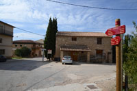
At the intersection of the highway to Arnes with Calle Onze de Setembre, we take the road to the right, passing along a detour towards one of the old snow wells of the village (located at a height of around 400 metres, within an olive grove in the outskirts). The street of Onze de Setembre changes its name to Calle Aragó near the information centre of Arnes, located in a former oil mill.
After 200 metres on this road, we turn left, leaving behind the last houses of the village and walk for a few metres along the road that leads to Toll de Vidre (7 km away), a picturesque section of the Algars canyon where the river has dug a pool with a small waterfall and which is currently equipped as a bathing zone.
After passing by a livestock holding, we come to a fork where we leave the road to Toll de Vidre and take the path to the right which descends to the ravine of La Maria. The road then ascends and the olive groves begin to give way to evergreen oaks and pines, with the River Algars accompanying us all along the route.
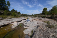
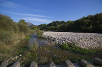
The final change of province, so frequent in earlier stages, takes place at more than 2 km into this section, when we cross the Algars for the last time, by means of a concrete bridge along a dike with a stream gauge near the enclave known as Toll de la Verdura.
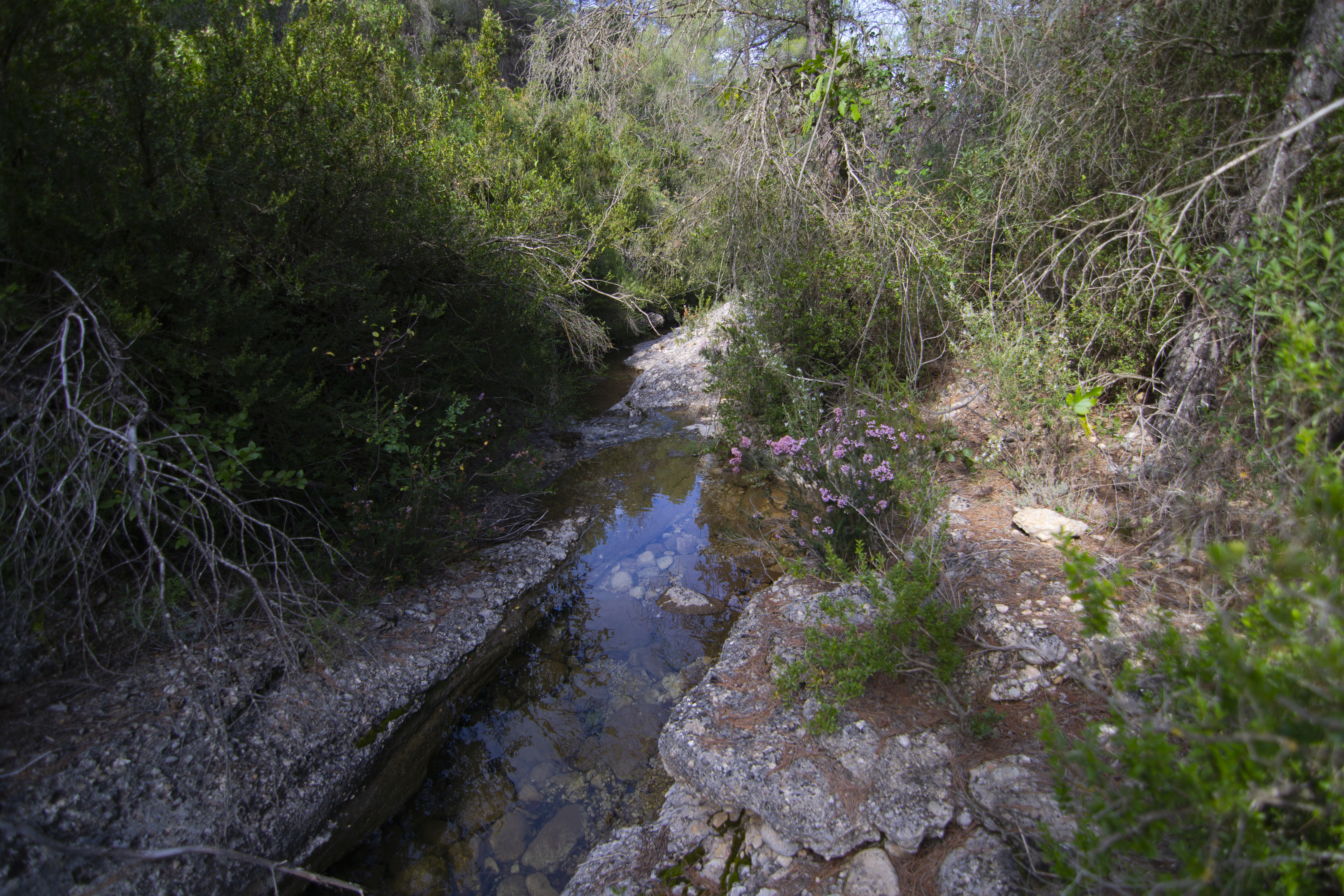
After a gentle ascent, now on the Teruel side of the river, the trail turns left and continues through a similar landscape of pines and evergreen oaks, with the occasional olive grove on the river bank. We advance until we come to a bridge on the ravine of La Tremolosa, the main highlight of the following section of the trail.

From this point onwards, the Nature Trail bids goodbye to the River Algars, its faithful companion during the last 3 stages, which continues flowing to the southeast while the trail takes the southwest route. After a fork where we take the path on the right, the trail begins to slope upwards, going around an olive grove. The landscape is now densely forested by pines with Mediterranean undergrowth, and the occasional evergreen oak.
The trail descends after crossing another olive grove, in search of the ravine of La Tremolosa. It leaves the forest route to the right and takes a dirt road straight ahead. From now on, the ravine to the right of the trail will be our constant companion and we begin a continuous ascent that only stops at the end of the ravine.
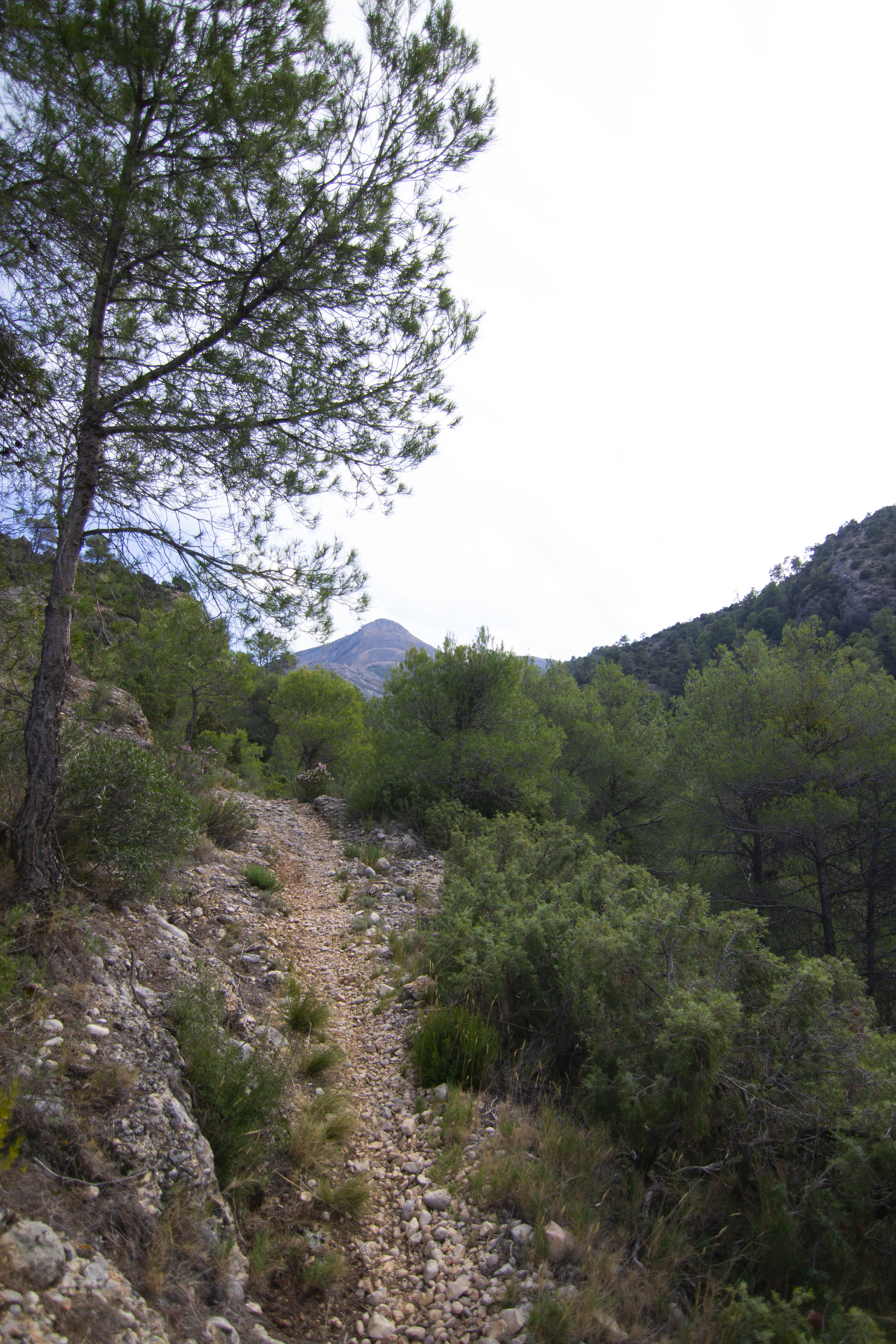
Half a kilometre later, the forest path is exchanged for a pedestrian path (from here onwards, the trail is no longer suitable for bikes) that extends for the next 2 km. This is the hardest section of the entire stage (with the exception of some sections in Stages 1 and 2 of the Nature Trail) both due to the incline (a maximum of 7%) and due to the road surface, its limited width and the loose earth.
For the first 400 metres we continue to pass through the aforementioned pine groves but then we come to a section 300 m long where the land is almost bare and we must be extremely careful as the walls are steep and the fall on the right of the road may be dangerous. On at least two occasions we must walk over rocks (extreme caution is required if they are wet) instead of earth. Even so, the views of the valley created by the ravine are well worth the effort and precautions taken.
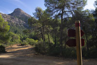
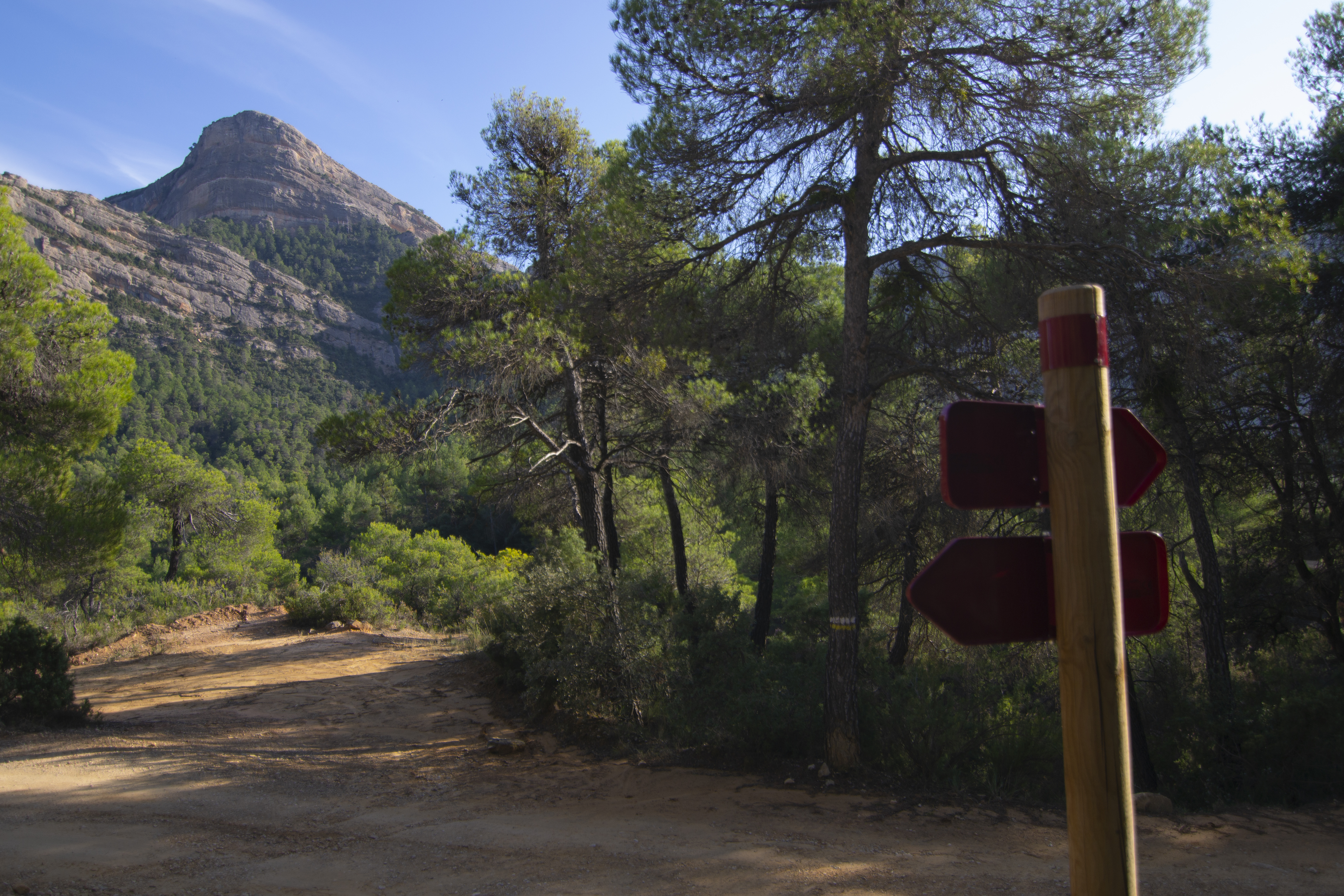
For the rest of the pedestrian path we are no longer accompanied by the ravine of La Tremoloso that continues to the southwest, as the path turns to the south, now with views of the Peña Galera peak. After a somewhat demanding final uphill climb due to the fact that the soil may be quite loose, we come to the end of the incline at a wide and firm forest road.
We now descend gently but constantly, and the landscape becomes a pine grove similar to that of the earlier section, later substituted by olive groves and subsequently, fruit orchards.
The trail continues along the ravine of Coll d’en Selma for 3 km, which is barely noticeable except for the presence of riverside vegetation. Now firmly in agricultural territory after passing by a poultry farm and some livestock holdings, the trail comes to the River Ulldemó flowing along the right for more than 1 km along a path that is now paved.
We cross the River Ulldemó by a concrete ford with pedestrian sections and proceed through livestock holdings and orchards, ignoring all detours on both sides of the trail. One of these detours (750 m from the river crossing) lets us access the highway to reach the area called La Pesquera, where the enclosed River Ulldemó forms various pools that are suitable for bathing.
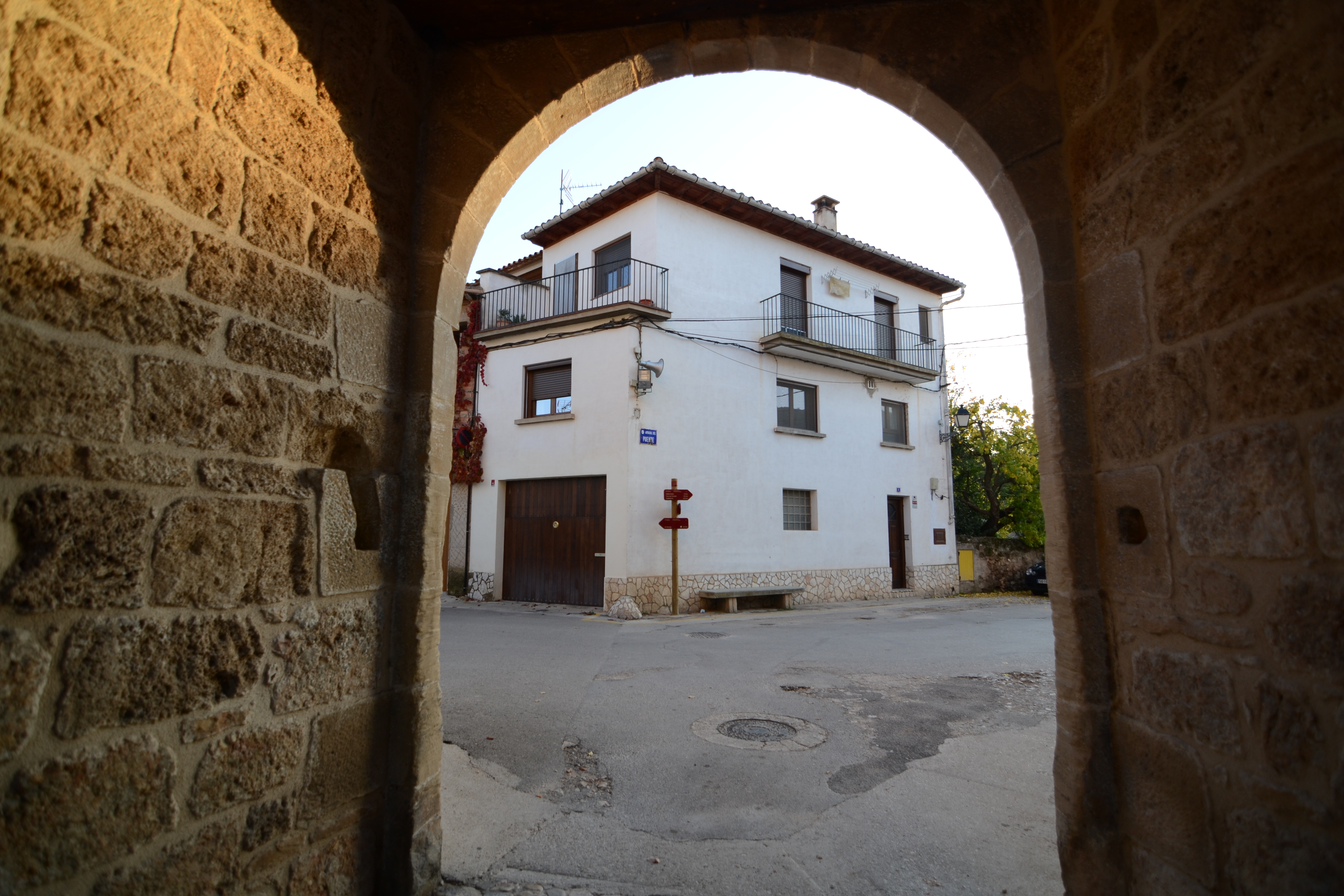
The trail finally arrives at the first houses of Beceite, near a parking lot and a fountain, and continues through Calle Llana until it enters one of the picturesque streets of this town. Although the trail continues towards the junction with Calle Diputación, it is worth approaching the square where the town hall and church are located (it is usually a good idea to walk around the narrow streets of the city’s old quarter).
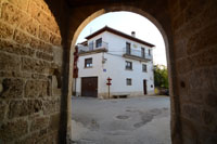
We leave the old quarter by Calle Villanueva, underneath an arch that leads to Calle Ronda, where this stage of the Nature Trail of Matarraña-Algars comes to an end, and after 12 stages and more than 150 km, finally reconnects with Stage 1.
Map
Puntos de Interés
Hidrografía
Información
Orografía
Vegetación
Profile
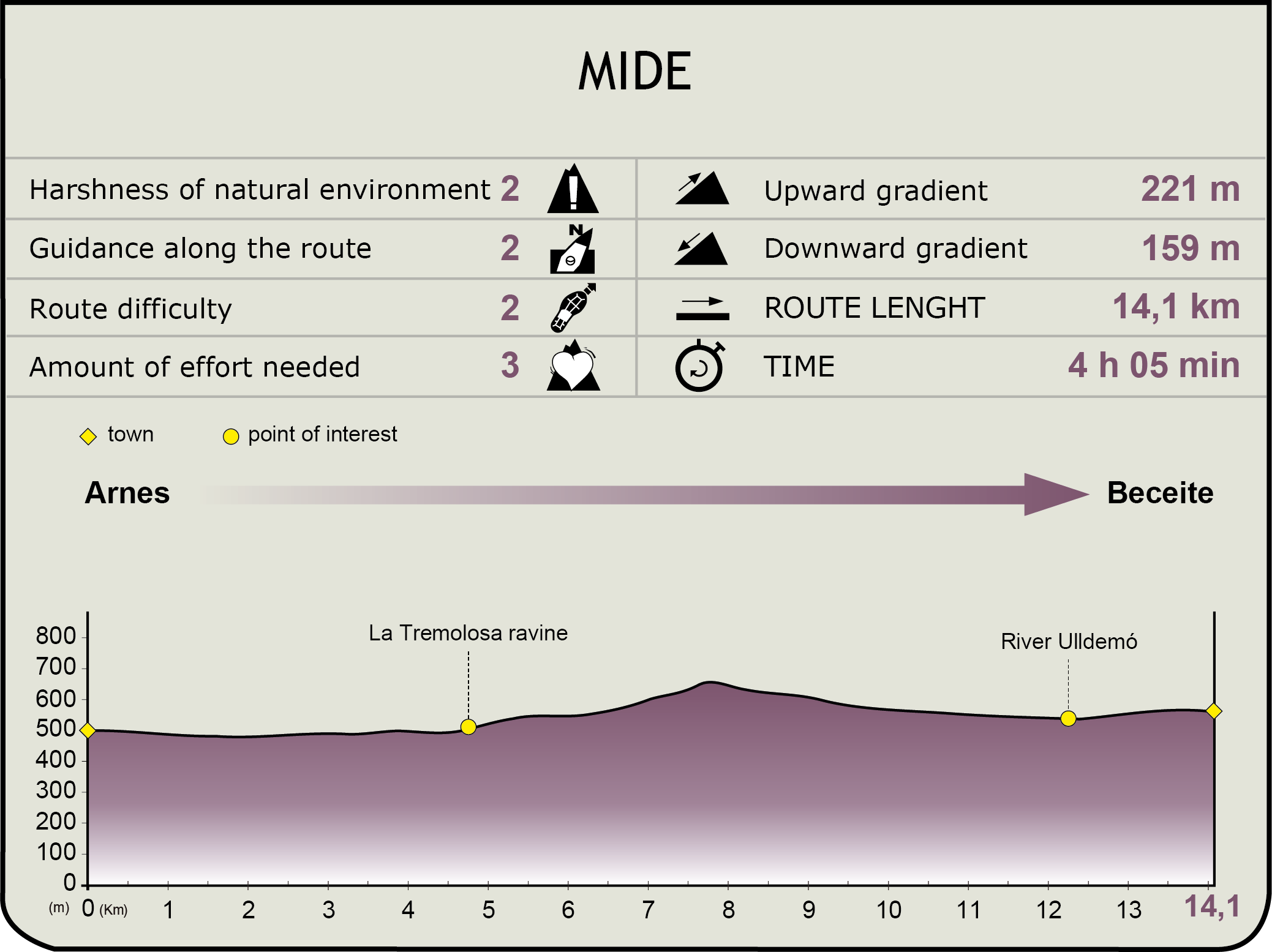
MIDE (Method for the Information of Excursions)
 Harshness of natural environment
- 1. The environment is not risk-free
- 2. There are more than one risk factors
- 3. There are various risk factors
- 4. There are quite a lot of risk factors
- 5. There are many risk factors
 Guidance along the route
- 1. Well defined trails and crossings
- 2. There is a clearly marked trail and signage
- 3. Requires the identification of geographic features and cardinal points
- 4. Requires off-path navigation
- 5. The trail is interrupted by obstacles that have to be gone around
 Route difficulty
- 1. Walking on a flat surface
- 2. Trails with different types of path
- 3. Walking on stepped paths or irregular terrain
- 4. The use of hands or jumping over the terrain is necessary
- 5. The use of hands is required to progress
 Amount of effort needed
- 1. Up to 1 hour of continuous walking
- 2. Between 1 and 3 hours of continuous walking
- 3. Between 3 and 6 hours of continuous walking
- 4. Between 6 and 10 hours of actual walking
- 5. More than 10 hours of continuous walking
Featured
Further information
Arnes
A town in Tarragona, its origins are uncertain. It was initially thought to have been a Saracen alquería (agricultural holding) conquered by Alfonso II who included it in the Templar grant of Horta de Sant Joan for resettlement. As was the case with the rest of their assets, when the Templar Order was disbanded, the town was passed on to the Knights Hospitaller and remained church property until the Madoz confiscation (mid-19th century). The village derives its name from the Catalan word arna, or moth, as its coat of arms depicts two of these insects.
Its town hall, one of the first Renaissance buildings in Catalunya which dates back to 1584, its Baroque parish church (dedicated to Saint Magdalene) built in 1693 on the remains of an earlier Gothic church, and its gateways that lead to the old quarter of the city, have significant architectural worth. On the outskirts of the village we can find the shrine of Santa Madrona (15th-16th century, although it was considerably damaged in a fire during the Civil War) and the snow well, a typical rural construction in Catalunya, built to gather and store snow and ice in winter that could be used later.
Although the economy of this town has traditionally focused on livestock and agriculture, the development of the tourism sector in recent years has halted depopulation (a large part of the town is located within the Natural Park of Los Puertos), Arnes has become a frequently visited area. A honey festival has been held since 2003 and it has enjoyed considerable success both within the region and in bordering areas in Catalunya and Aragón.
Beceite
Beceite, which lies in Teruel, is one of the most attractive areas in the region of Matarraña. It is situated at the foothills of Puertos de Tortosa-Beceite, a mountain range of great beauty and environmental and geological significance with heights greater than 1,200 m. Three rivers emerge within the municipal territory of Beceite, among them the Matarraña which lends its name to the region.
The town's name is derived from the Arabic bayt Zayd or house of Zayd, which, similar to other toponyms in Aragón with the same root (Calaceite, Zaidin, Binaced, etc.), suggest the presence of the Shia minority, the Zaidis. Iberian remains have been found, similar to many other areas in the region, and the cave paintings of La Fenellosa demonstrate that the area was inhabited at least from the Bronze Age onwards. Of its medieval heritage, there are a few remainders, such as the five gateways that provide access to the town, the gateway of San Gregorio being a notable example. It is also worth visiting the stone bridge that provides access to the town and was built in the 15th century to prevent the town from being cut off by rising river levels.
Another sight of interest is its town hall, built in the late 16th century, and a witness to different events throughout history. The building was burnt on several occasions, the last time being during the Carlist Wars that ended in 1840. Additionally, in 1933 during the anarcho-syndicalist revolution in the town, the building was occupied and the municipal archives torched. It has also been the residence of the archbishops of Zaragoza prior to the ecclesiastical disentailments and later became the headquarters of the Sociedad de Socorro Mutuo (Society for Mutual Aid) subsequently also fulfilling the roles of prison, cinema hall, theatre and bar. The 17th century church of San Bartolomé, built on the ruins of an earlier 13th century church is also worth visiting.
For centuries, the main economic driving force of the town was the paper industry, owing precisely to its natural environment, as paper production depended on the waters of the Matarraña. Nevertheless, after several centuries of intensive production, the paper mills finally ceased working in the 70s. Currently, the town’s economy is dependent on pig and sheep herding, supplemented by olive and almond cultivation, although the tertiary sector, tourism and hospitality seem to offer the greatest possibilities for the future, making Beceite one of the most tourist-friendly areas in the province of Teruel.
Multimedia


Downloads
GPS Downloads
Cyclability
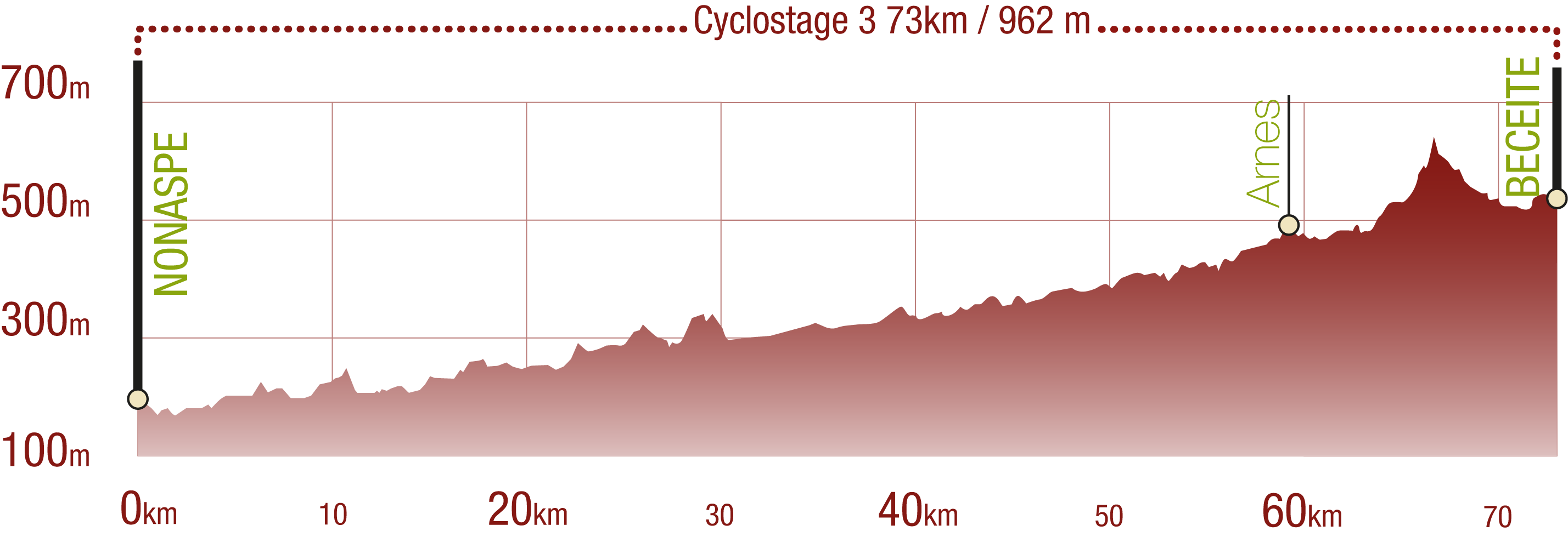
This Cyclostage correspond to stages 10 to 13 of the Nature Trail
PROFILE
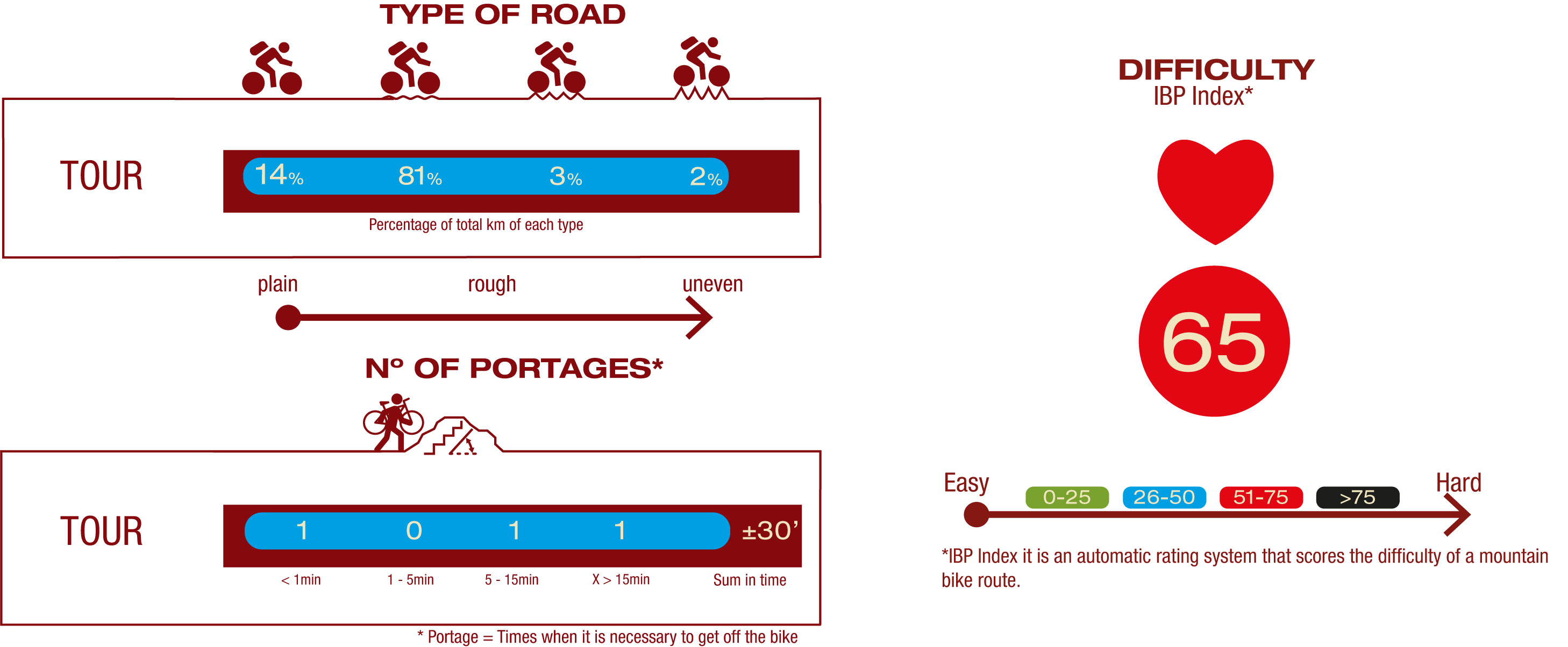
TYPE OF ROAD, PORTAGES & DIFFICULTY
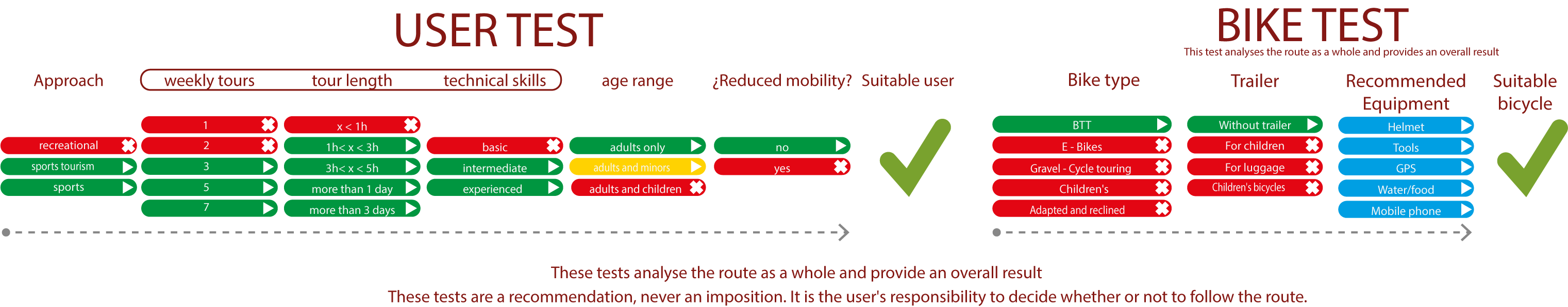
TEST
SAFETY RECOMMENDATIONS
- Sections shared with hikers.
- Transit through the centre of some population centres.
- Due to the fact that the route runs close to riverbeds, crossing them on several occasions, you are informed that there may be seasonal discontinuities caused by floods, increases in flow, floods or transit through flood-prone areas.
GENERAL RECOMMENDATIONS
- Find out about the technical aspects of the route and the weather on the day.
- Take care of the environment. Take care not to disturb animals or damage vegetation. Respect private areas.
- You must give priority to pedestrians and comply with general traffic rules.
- The environment in which you will be riding is open, free to move around and an area where many activities are carried out (sporting, forestry, livestock and agricultural activities). Always have an understanding, prudent, responsible and respectful attitude.