
- Home
- Rural Development
- Nature Trails
- Nature Trails
- Northeast Sector
- Matarranya Algars
Stage 11. Caseres - Arnes de Lledó
Description
The River Algars runs between small hills with pine forests
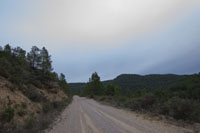
At somewhat less than 10 km, this short stage runs through pine groves that make up some of the densest forests in the region of Matarraña.

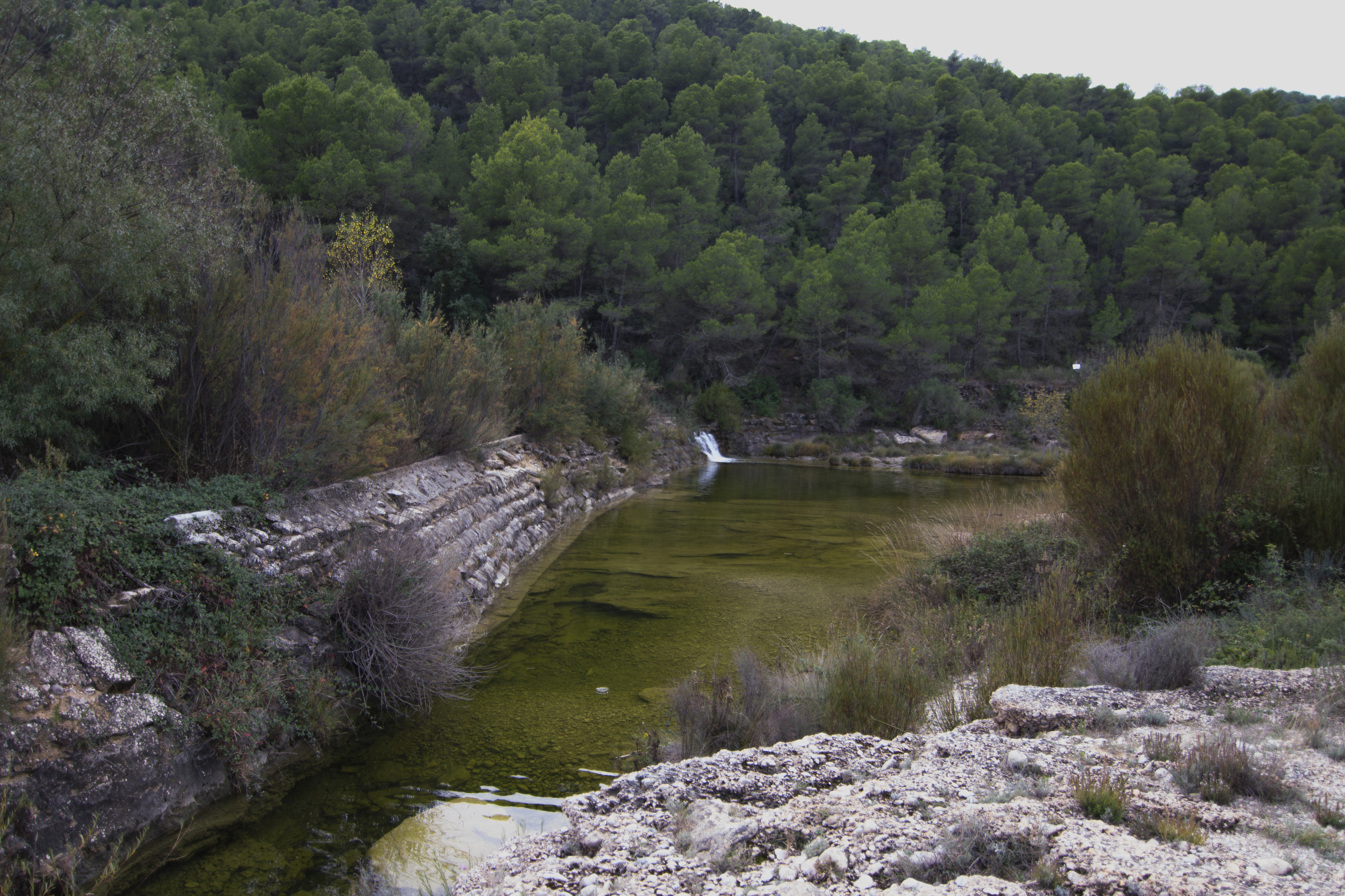
This stage begins on a wide path that leaves Caseres behind among orchards, farmlands and livestock holdings. To the right, the slowly flowing waters of the Algars form pools and patterns on the rocks in the river bed and on the other bank, the hills are completely covered by pine trees. After a kilometre and half, we pass by a river weir (the weir of Vidiella), where we can take a detour that leads to a recreational area equipped with tables, chairs, and barbecue equipment.
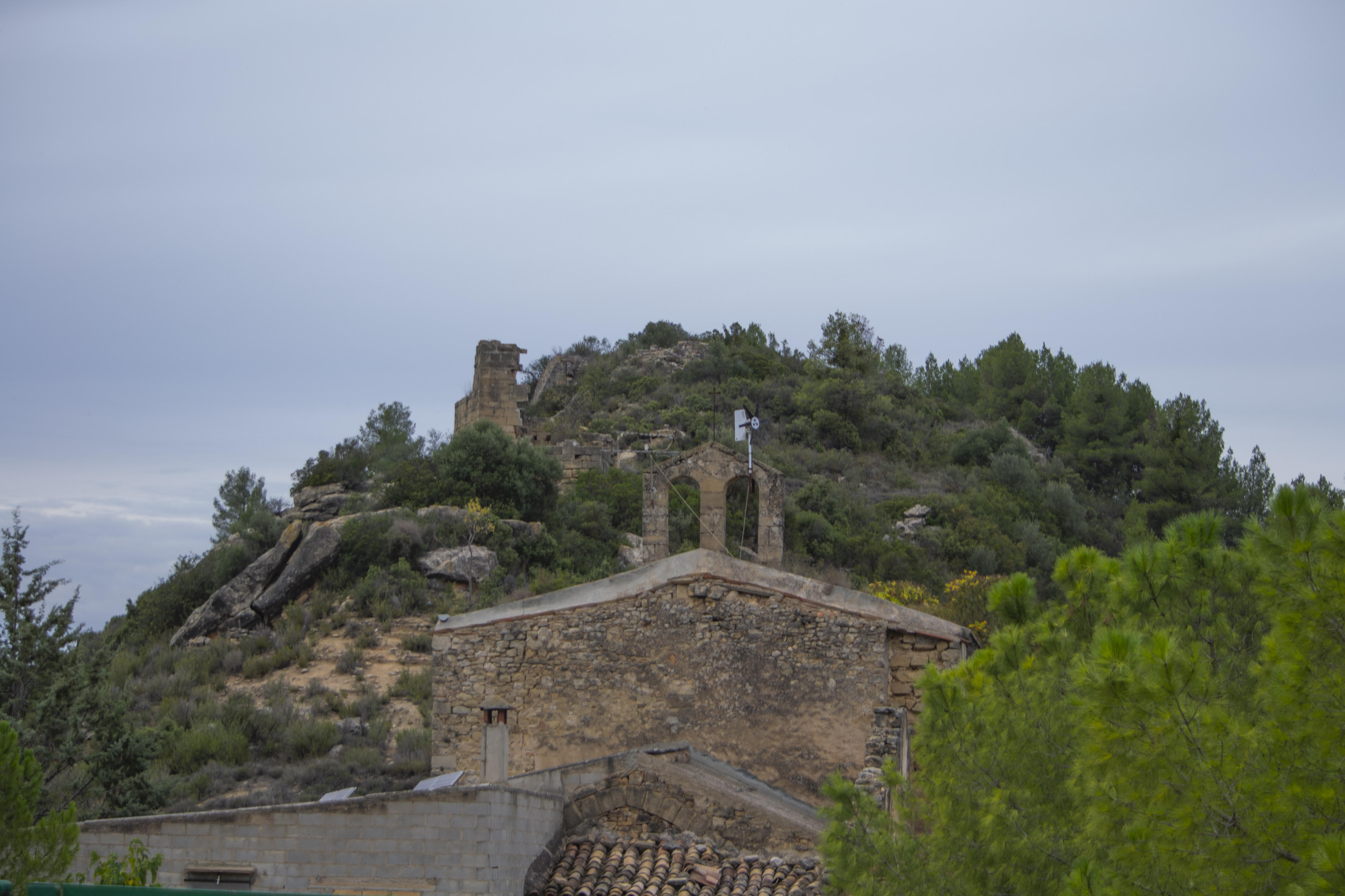
The trail turns left and approaches the ruins of Almudefár, a village in Caseres where the only building still standing is the old parish church of Santa Ana (private property and not used for religious services), and the remains of some stone walls on the top of the hill, that are part of a former castle that was once an important frontier stronghold.
The trail now turns left and passes between a ruined building and a livestock holding to subsequently enter a pine grove. It continues at mid-slope level for a kilometre and half before taking a turn to the right near an orchard and crossing the river by means of a stone bridge. On the other side, and now in the province of Teruel, the route begins a gradual ascent between pine groves and riverside vegetation in the first section, which is later replaced by farmland and orchards when the river valley widens out.
These orchards and farmlands become progressively more common as we approach Arens de Lledó and after somewhat more than 5 km, we come to the crossing with the TE-V3341 highway. At this point, we have two choices: we can continue on the highway (although it passes by the village, precautions must still be taken as there are very small side lanes and no pavements) until the end of this stage within the urban centre; or we can take a detour on the left (50 metres ahead) that descends to the river, crosses it by a bridge and rejoins Stage 12 of the Nature Trail after one kilometre.
The second option is recommended for cyclists in order to make a more comfortable crossing over the river (as we shall see in the next stage, the first option forces the cyclist to cycle over uneven rocks after crossing the river over the concrete ford built for this purpose).
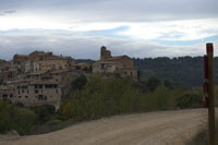
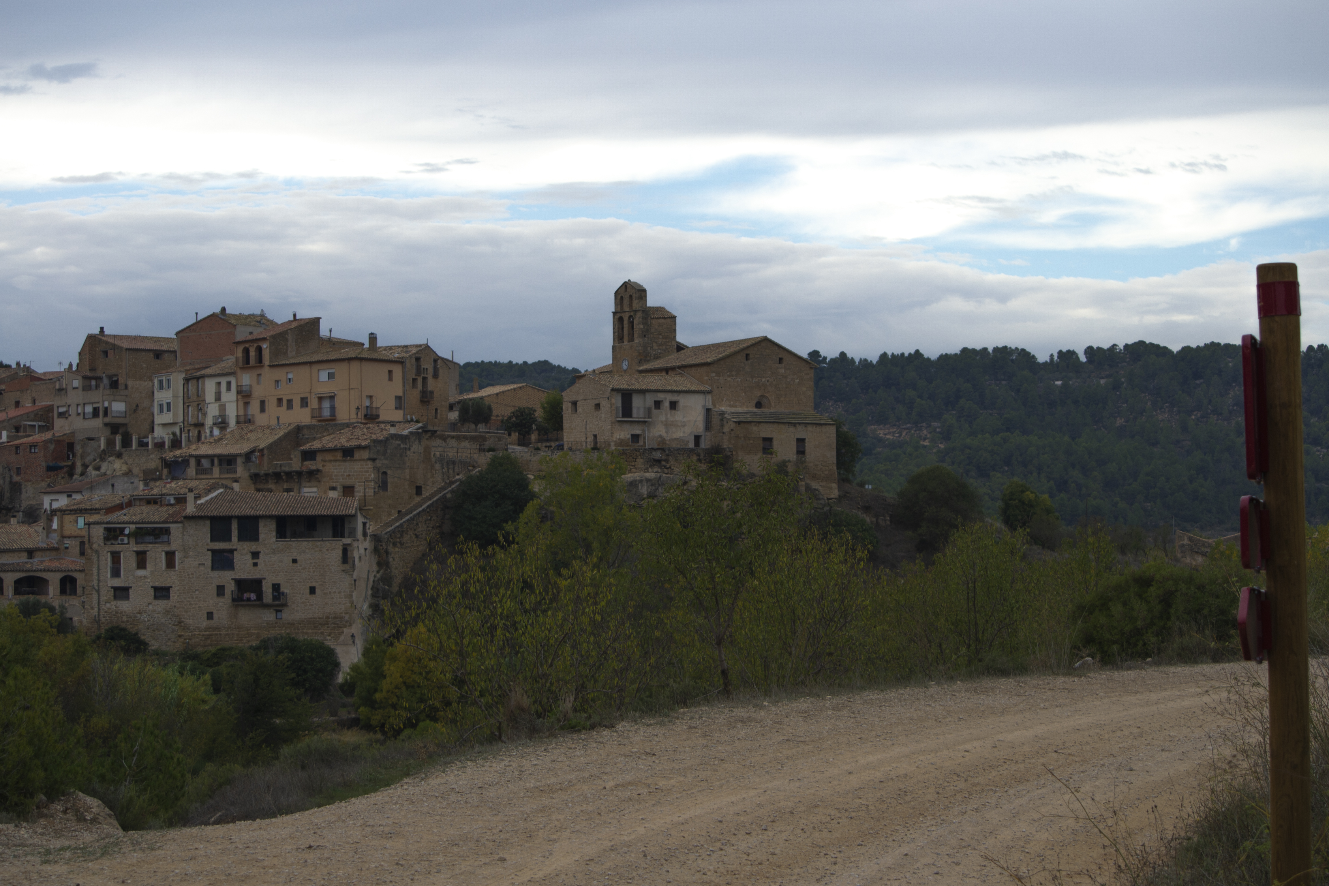
Following the first option, less than 400 m away is the end point of the stage next to «lo Raig» (el chorro, in Spanish), as the small waterfall produced by the canal of Arens is called. A walk through the streets of this town is highly recommended, especially a visit to the Plaza Mayor and the church of La Asunción which stands next to a viewpoint with impressive views of the valley of Algars.
Map
Profile
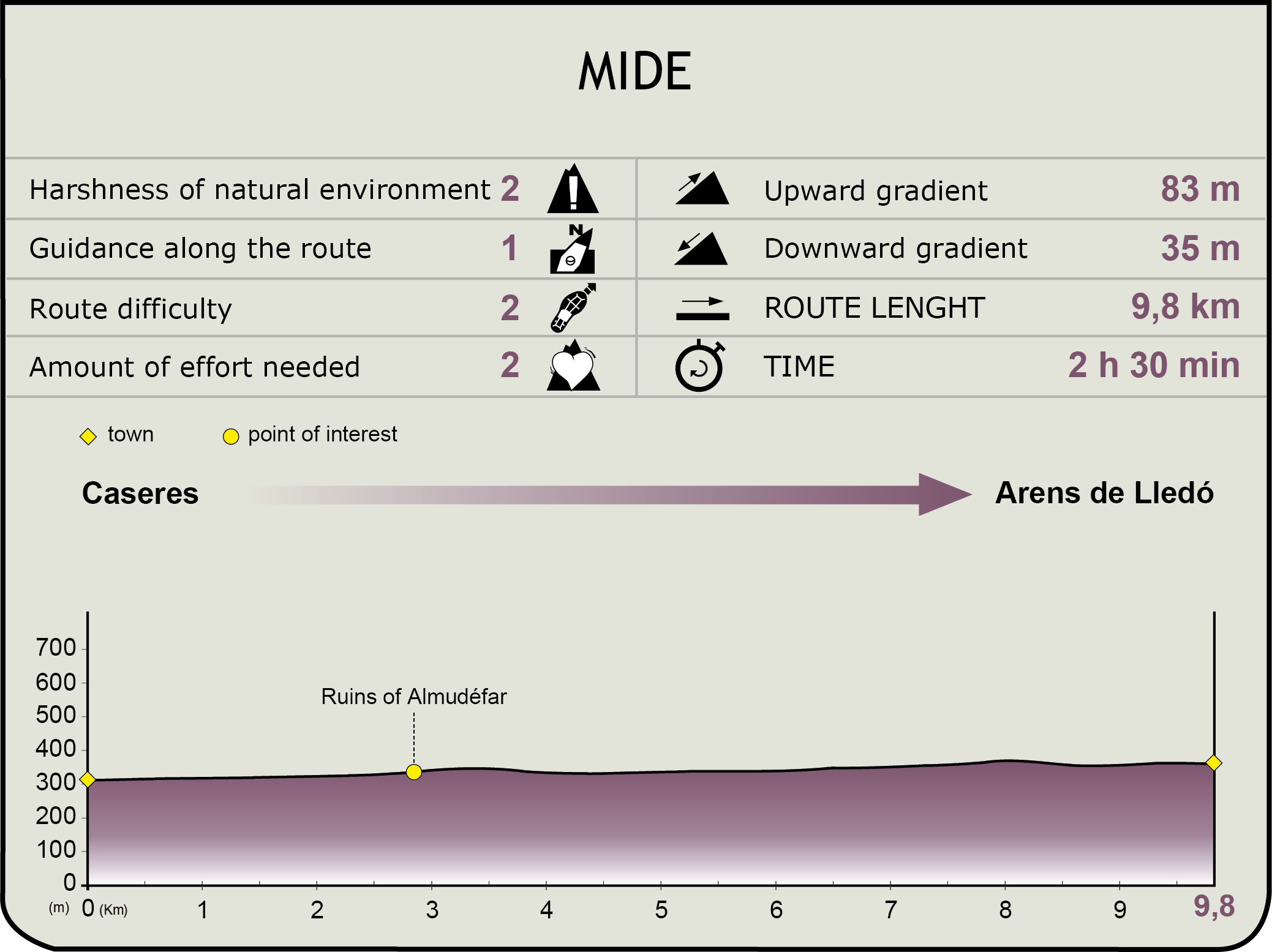
MIDE (Method for the Information of Excursions)
 Harshness of natural environment
- 1. The environment is not risk-free
- 2. There are more than one risk factors
- 3. There are various risk factors
- 4. There are quite a lot of risk factors
- 5. There are many risk factors
 Guidance along the route
- 1. Well defined trails and crossings
- 2. There is a clearly marked trail and signage
- 3. Requires the identification of geographic features and cardinal points
- 4. Requires off-path navigation
- 5. The trail is interrupted by obstacles that have to be gone around
 Route difficulty
- 1. Walking on a flat surface
- 2. Trails with different types of path
- 3. Walking on stepped paths or irregular terrain
- 4. The use of hands or jumping over the terrain is necessary
- 5. The use of hands is required to progress
 Amount of effort needed
- 1. Up to 1 hour of continuous walking
- 2. Between 1 and 3 hours of continuous walking
- 3. Between 3 and 6 hours of continuous walking
- 4. Between 6 and 10 hours of actual walking
- 5. More than 10 hours of continuous walking
Featured
Further information
Arens de Lledó
This municipality in the region of Matarraña, which was granted the status of Villa in 1785, is located in the easternmost zone of the province of Teruel, and shares a border with Terra Alta in Tarragona (Catalunya).
The zone has been inhabited since the Bronze Age and different Iberian burial mounds have been unearthed in the municipality (in good states of preservation; a route has been made available to visit them). From the Islamic period we have one of the weirs that diverted water from the Algars to canals. There are still some remains of medieval walls. During the modern age, it suffered, as did many other villages in the area, damages incurred in the Spanish Civil War, when the municipal archive was burnt.
A fine example of religious architecture is the church of La Asunción (declared a Site of Cultural Interest in 1983), built in the Gothic style (14th century) in masonry, although it was expanded in the 17th century, and alongside we have the remains of what was once a 16th-century Franciscan convent, now greatly changed from its original structure. 6 kilometres to the west of the urban quarter we have the 18th-century shrine of San Hipólito (or San Pol, built over an earlier medieval structure); located on a high section that dominates the zone and is still an important religious and pilgrimage site.
Some noteworthy civil constructions are the Plaza Mayor and the Town Hall which is built in a 17th-century Renaissance style, the Casa de la tía Soledad, a Modernist building constructed in the early 20th century that, with its five floors, is the tallest building in the village.
Almudéfar
The name of this enclave is derived from the Arabic al-muzaffar which means “the victor”. The first mention of Mudéfer dates back to 1280 when the commander of Miravet granted the village to some people of Horta and in 1358 it already had 15 inhabitants. This area was inhabited at least until the mid-20th century.
It was finally incorporated into the municipality of Caseres in 1842 (region of Terra Alta, Tarragona). Today, all that remains of this village are a few ruins, the church of Santa Ana and the vestiges of the Castle of Almudefer at the top of the hill where it once stood.
The castle is known to have existed since 1267. It was part of the Templar grant of Horta de Sant Joan, and was built by the Christians, as no mention of this structure is made in the Miravet grant of 1153. In 1643, during the Reapers’ War, the village was sacked by the troops of the Count-Duke of Olivares.
The parish church of Santa Ana is located at the foot of the fort, with a 14th-century Gothic polygonal apse.
Multimedia

Downloads
GPS Downloads
Cyclability
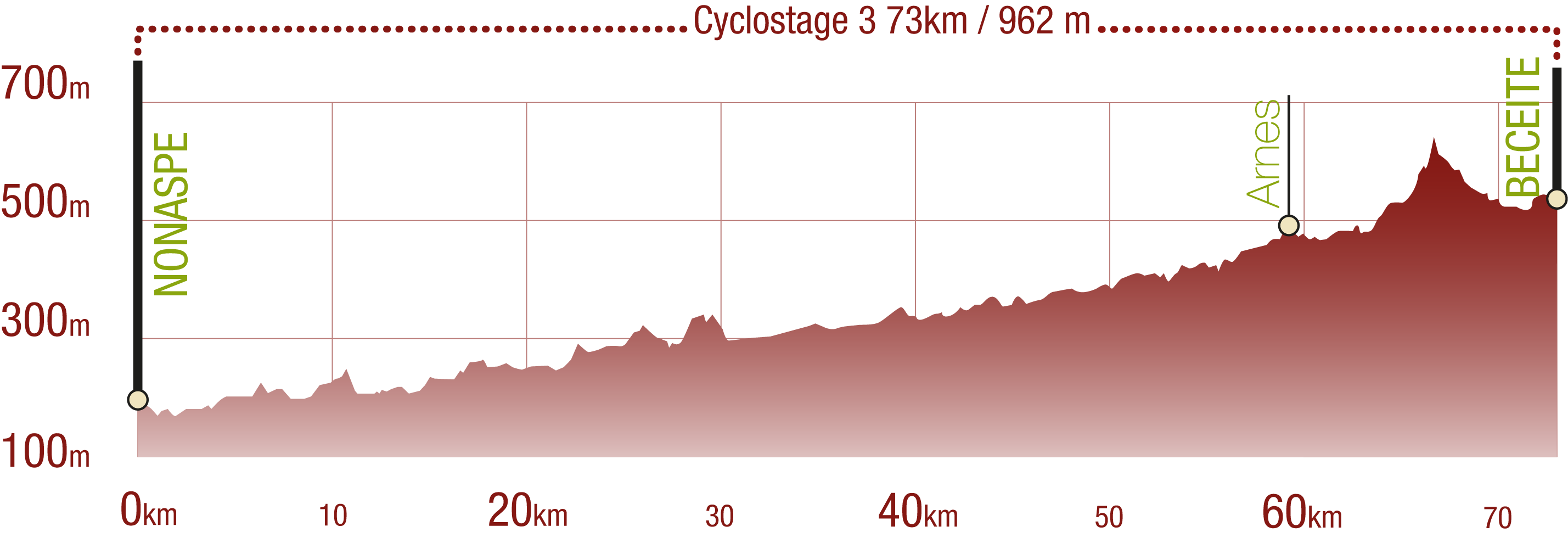
This Cyclostage correspond to stages 10 to 13 of the Nature Trail
PROFILE
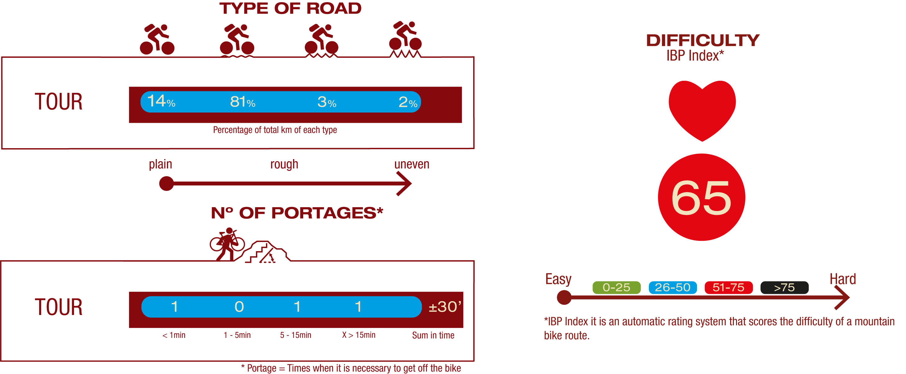
TYPE OF ROAD, PORTAGES & DIFFICULTY
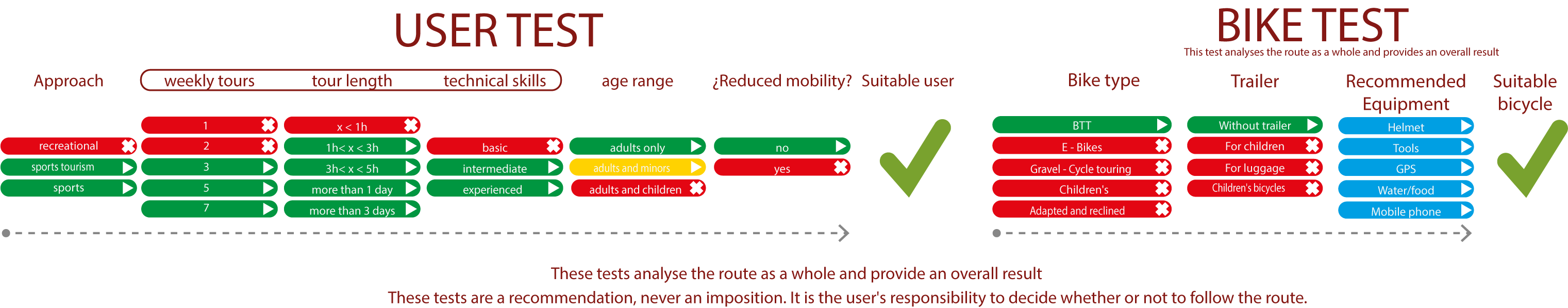
TEST
SAFETY RECOMMENDATIONS
- Sections shared with hikers.
- Transit through the centre of some population centres.
- Due to the fact that the route runs close to riverbeds, crossing them on several occasions, you are informed that there may be seasonal discontinuities caused by floods, increases in flow, floods or transit through flood-prone areas.
GENERAL RECOMMENDATIONS
- Find out about the technical aspects of the route and the weather on the day.
- Take care of the environment. Take care not to disturb animals or damage vegetation. Respect private areas.
- You must give priority to pedestrians and comply with general traffic rules.
- The environment in which you will be riding is open, free to move around and an area where many activities are carried out (sporting, forestry, livestock and agricultural activities). Always have an understanding, prudent, responsible and respectful attitude.