- Home
- Rural Development
- Nature Trails
- Nature Trails
- Northeast Sector
- Hoya_Huesca
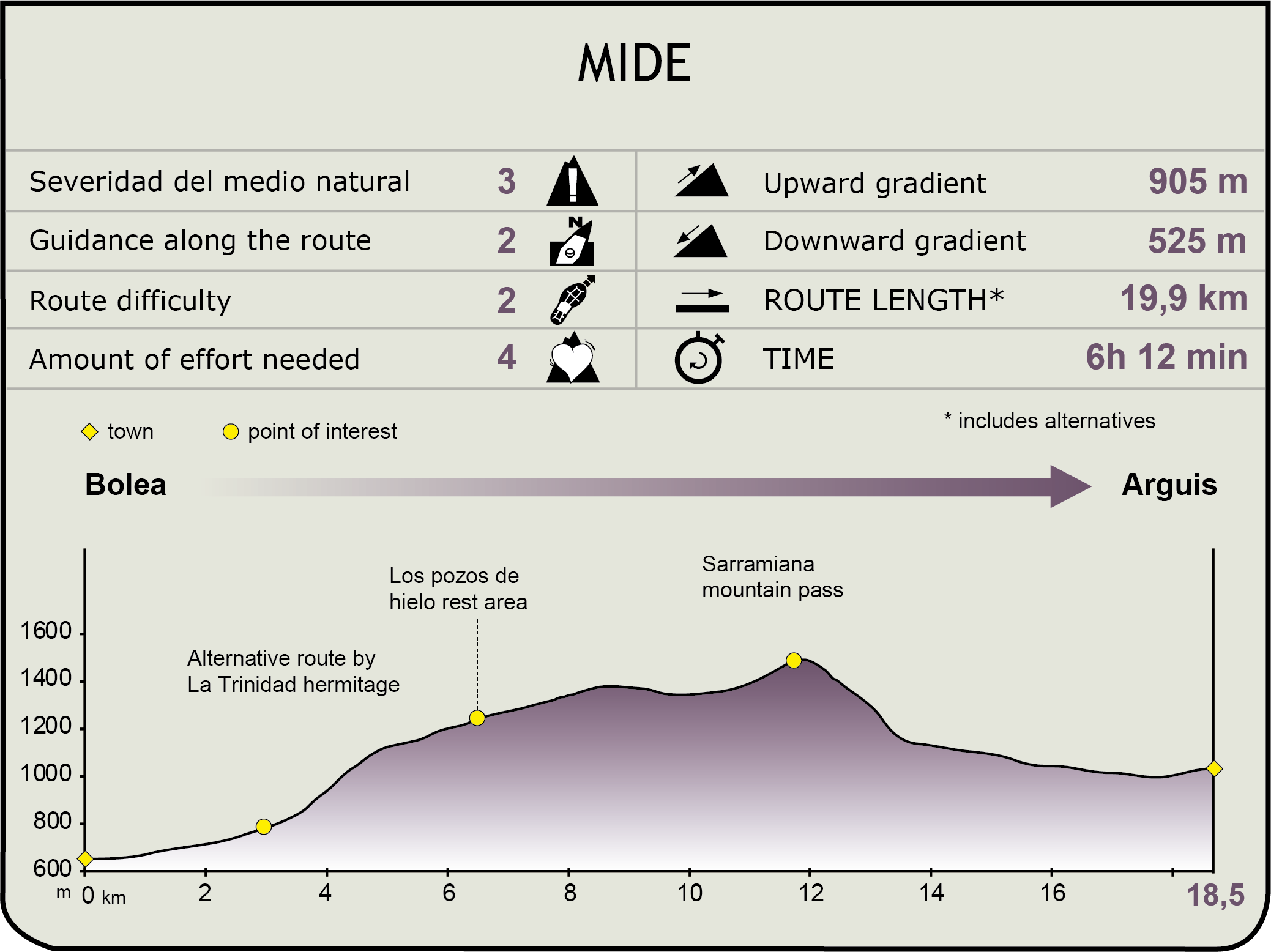
Stage 4: Bolea – Arguis
Description
From the plain of Huesca to the Pre-Pyrenean Sierra
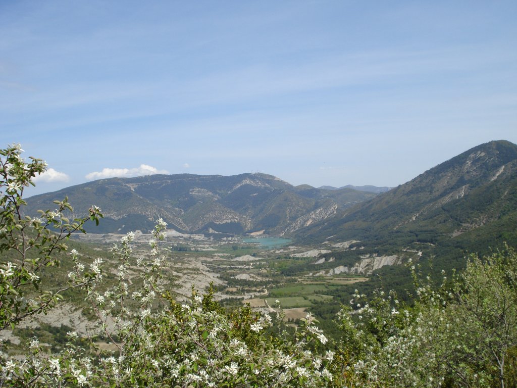
The fourth Stage of the path of La Hoya de Huesca leaves from the village of Bolea and ends in Arguis. It crosses the Sierra of Gratal through the municipalities of La Sotonera and Arguis and the first part of the route coincides with the itinerary of the GR-1. During this tough but beautiful Stage, you reach the highest altitudes on the Nature Trail. The highest point is on the hillock of Sarramiana, which offers excellent panoramic views of La Hoya de Huesca, the Sierra of Gratal, the Sierra of Bonés and of the Pyrenees. Visitors also have the opportunity to cross an area of great ecological value, the beech grove of Peiró.
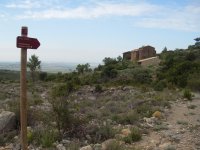
This 18.5 km Stage leaves from the point where Stage 3 ends, located to the north of Bolea, at the intersection with the road that leads to Puibolea (HU-V-3141). Taking the road to the left for 200 m, you reach an informative panel on the Nature Trail, which is the starting-point for the track you should take to Arguis. There is also a small circular route that enters along Calle Mayor as far as the square, which leads, once again, to this panel, after surrounding the village on its eastern side.
After taking the track that leads to the convent of La Trinidad, and which coincides with the route of the GR-1, you make your way among fields of fruit trees, mainly cherries (Prunus avium), passing on your right a couple of turn-offs for rural paths. A little further on, you come to a path intersection where there is an iron cross on your left; carry on following the signpost for Arguis.
Continue along the main track among olive trees(Olea europaea) and cherry trees (Prunus avium), passing a path intersection ahead, until you reach a fork on the left, some metres before an irrigation point with a fountain, a table and benches for resting.
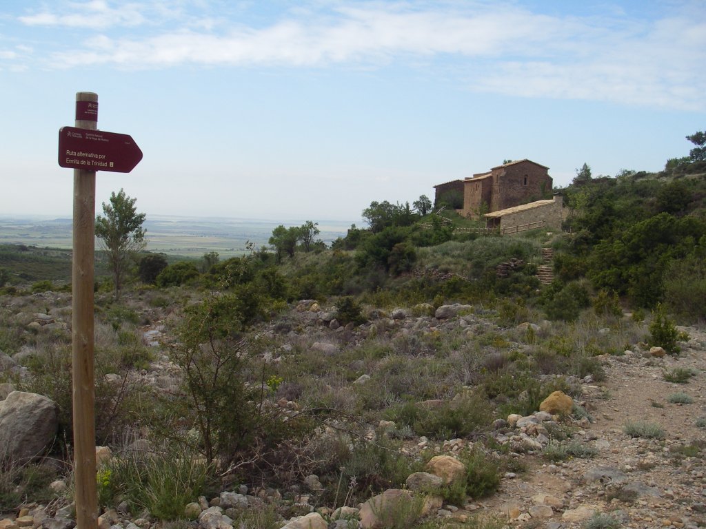
Cross these fields where the well-known Bolea cherry is grown and, after a few hundred metres, you will come to a fork where there is an informative panel and a signpost for the alternative route by the chapel of La Trinidad. Here, travellers have two trail options; on the left following the alternative route or, on the right, towards the Snow Wells. Both routes join up again a little further on after the convent of La Trinidad.
Following the main route towards the Wells, you continue a few metres until you reach a fork, which is the starting-point for a track on the right for vehicles going to the Ice Well. The Nature Trail itinerary heads leftwards towards the Ice Well along a path, which, in a few metres, reaches the ravine alluvial, where it is joined by the alternative route from La Trinidad.
You can access the convent of La Trinidad, founded by the Barefoot Augustinians in the 17th century, via a track that ascends on the left-hand-side from the previous turn-off. This monastic site, which has been in private hands since the 19th-century disendowment, currently preserves the restored church, a fountain, a ruined inn and the remains of the walls of other buildings belonging to the site. Next to the chapel, you will discover a rest area and a building used in the pilgrimage that is held here on the Sunday after Corpus Christi. To the right of the site, the path heads downwards via some steps as far as the riverbed, joining the main route. The path carries on along the right-hand-side of the ravine to then begin its ascent after crossing the irrigation canal of Alicastros, which brings irrigation water from the ravine to the kitchen gardens of Bolea.
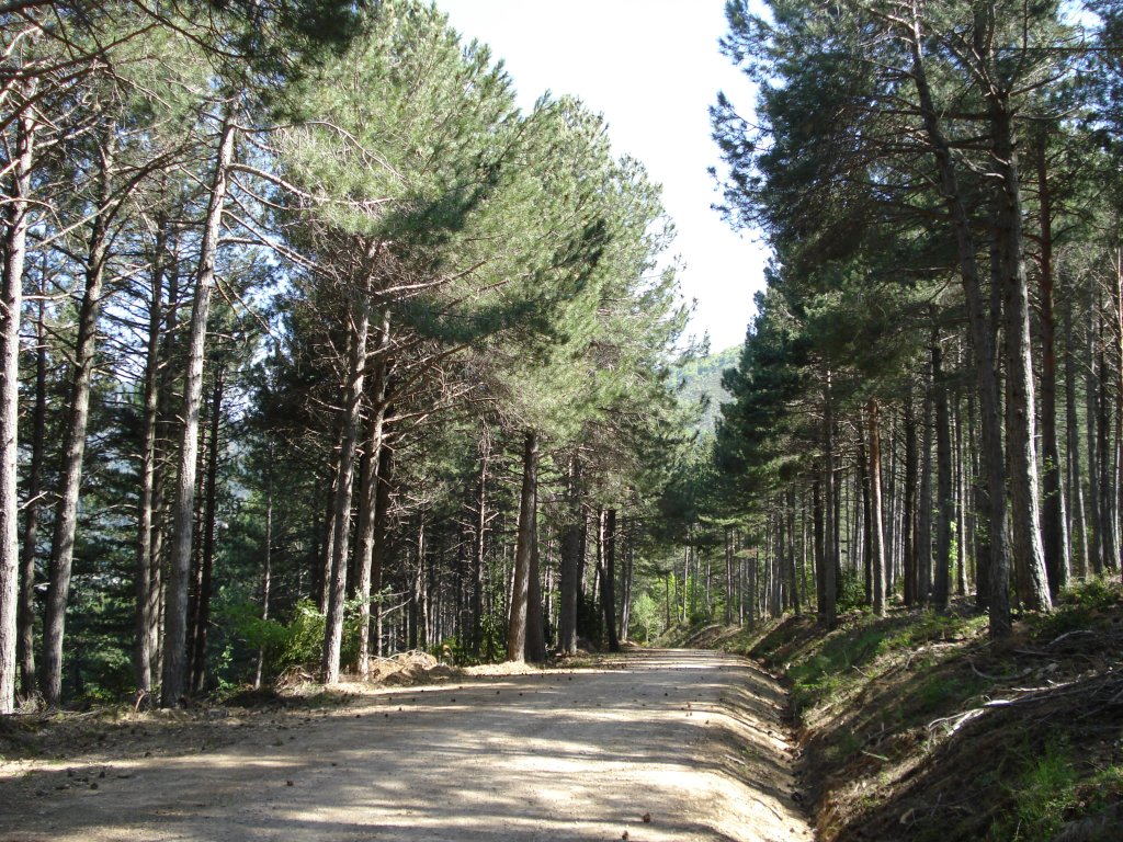
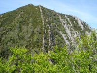
You begin climbing via sections with steps and wooden railings, crossing an area of box brushwood (Buxus sempervirens), kermes oak(Quercus coccifera), gorse(Genista scorpius) and thyme (Thymus sp.) to then enter the pine grove (Pinus sylvestris), where you can see natural sandstone rock steps that alternate with other grey limestone areas. The path continuously zigzags upwards across the pine grove and heads westwards via a less arduous steep area, where you will have good views of Bolea and La Hoya de Huesca.
The trail begins to climb once again and turns to your right to head across an area that is almost flat to a beautiful wild pine and box grove, where there are many pinecones on the ground. The path carries on bordering an area known as the Manantiales d´a Chordana where it crosses a ravine via stepping-stones and now continues eastwards among Pyrenean hedgehog (Echinospartum horridum), It borders the hillside as far as the hillock of the Wells, or Cuello d´os Pozos, through another impressive pine grove.
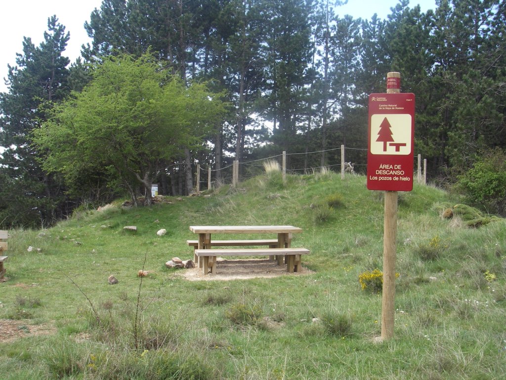
On the hillock, located at 1,256 m, you will come to the old ice well of Mata Menuda I and a rest area. The origin of the ice wells dates back to the 17th-century, and their purpose was to store snow in the wintertime so it could be used in the towns on the plain in the hot months. Due to the fact that, at this time, it was a product of great value, they were managed by the most important families in the area.
Several paths merge on this hillock; towards the west the track that leads to Aniés via the chapel of La Peña; towards the south, the track that leads to the chapel of La Trinidad and Bolea; towards the north the turn-off to Bentué de Rasal via the GR-1, and towards the west, the track that leads to Arguis, which is the route of the Nature Trail.
The trail leaves the route of the GR-1 at this point, leaving behind the dense pine grove to enter a brushwood area dominated by a formation of box and Pyrenean hedgehog. This latter species is thorny brushwood with a cushioned appearance that is endemic to the Central Pyrenees, covering eroded hillsides, ledges and crests with shallow stony soils, mainly in limestone lands. In addition to its mainly protective role against erosion, especially in these areas where other species cannot survive the harsh climate, the Pyrenean hedgehog also has great aesthetic value since, during its summer flowering, it covers these hillsides with a yellow carpet.
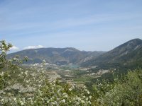
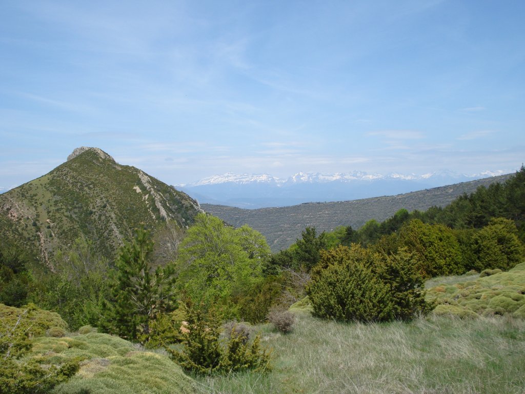
After climbing up the hillside and leaving behind a beautiful view of the Pyrenean peaks, you come to a small hillock where a panel containing information on the path stands. On the right, on the edge of the ravine, there is a rest area with an interpretative panel that forms a true natural balcony towards the Sierra of Gratal and La Hoya de Huesca. From here, visitors can contemplate the pyramid silhouette of the peak of Gratal, which, without being the highest point, is one of the most well-known altitudes of the eponymous sierra.
Once you have returned to the path and crossed a small stream where the fountain of El Zapo surfaces, you reach the entrance gate to a private estate, which you must cross via a side passageway. After a gently descending Stage, you pass by a path on the right with a gate that leads to Puibolea, and continue along the track enjoying the landscape where the box plants are larger than in the part of the route you have already covered.
The trail continues by crossing halfway up the hillside. After passing through the riverbeds of two small ravines, an upward Stage begins which becomes harder after taking a sharp bend on the left, where a path with a metallic gate merges that links up to the peak of Gratal, in the area of La Sarramiana.

The beauty of the surrounding area eases this long, arduous climb, which continues in a northerly direction ascending the Tacho irrigation ditch. Without barely any shelter from the sun and leaving the silhouette of the peak of Gratal behind you, you come to the highest point of the Nature Trail, the hillock of Sarramiana, which offers a spectacular view of the peak of Peiró and of the frequently snow-capped Pyrenees.
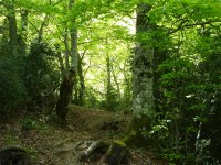
Now a path from this point onwards, the trail begins to descend through the surprising beech grove of Peiró, one of the most southerly in Huesca, whose natural values have made it worthy of the category of a Site of Ecological Importance under the name Monte Peiró-Arguis SCI. This luxuriant beech tree forest, containing specimens that are easily over 200 years old, is unusually associated with the yew (Taxus baccata), a long-lasting and highly toxic tree (the entire tree is toxic except for the red arillus covering the seed), instead of the habitual fir trees which appear in other beech groves in the Pyrenees. Other species such as box, honeysuckle(Lonicera sp.) and the wild violet(Viola sp.) appear in the undergrowth of this unusual beech grove. The descent is steep and the frequent humidity of the land makes it slippery on occasions, which is why you must pay attention in this Stage.
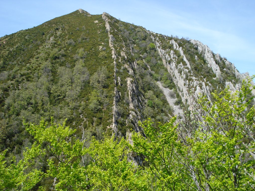
After the steepest slopes, you will come to an explanatory panel and a turn-off to the peak of Peiró, on the left of the route. At this point, the path turns rightwards to then continue descending halfway down the hillside, now with a much gentler gradient, protected by numerous sections of wooden railing and metal towropes. The more open sections of the forest offer an excellent view of the peak of Peiró and its characteristic vertical strata of limestone rock.
After leaving the north-facing ravine and the beautiful beech grove, the path heads eastwards where, little by little, other species such as gall-oak (Quercus faginea), quaking aspen (Populus tremula), whitebeam(Sorbus aria) and snowy mespilus (Amelanchier ovalis). make an appearance. In front of you, you will see the Sierra of Bonés and, to the east, the reservoir of Arguis in the foothills of the Sierra of El Águila. The path turns leftwards and descends a very steep Stage crossing a black pine grove(Pinus nigra), with box undergrowth.
At the end of the descent, you will reach a forest track that leads, on the right, straight to the dam of Arguis, but the Nature Trail continues leftwards as far as the beautiful village of Arguis. After going around a sharp bend, take the next fork on the right and carry on for some 800 m until the trail turns off the track to the left and changes into a path. After walking next to a small clearing among a dense pine grove, you will arrive at another track, next to the crossroads of the River Isuela.
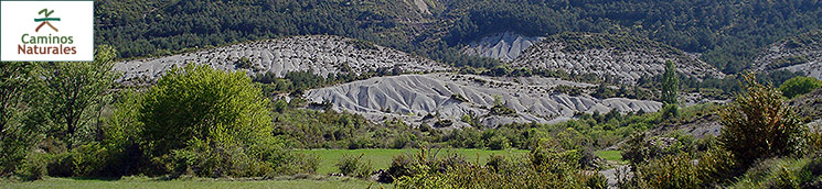
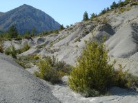
On continuing along this track, you will enjoy an unusual landscape of meadow terraces and marl lands, with countless channels produced by the erosion of these sedimentary rocks of marine origin. This greyish, muddy landscape, in some places almost lunar, will accompany you as far Arguis. You will reach this town after crossing the riverbed via two passing places, which, on heeding the signs, you should only use when the river permits.
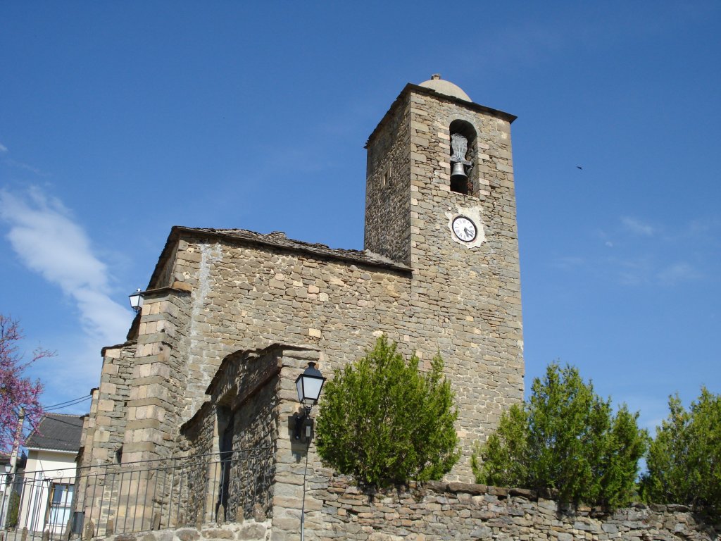
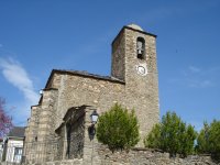
Now in the village of Arguis, surrounded by typical mountain architecture with stone houses, slate roofs and typical Pyrenean cone-shaped chimneys (chamineras in Spanish), you will come to a panel located next to some public washhouses where this tough but beautiful Stage comes to an end. Worthy of note in the village is the church of San Miguel, which dates back to the 12th century, whose altarpiece was made later in the 15th century by the Maestro of Arguis and which is currently located in the Prado Museum.
Profile
MIDE (Method for the Information of Excursions)
 Harshness of natural environment
- 1. The environment is not risk-free
- 2. There are more than one risk factors
- 3. There are various risk factors
- 4. There are quite a lot of risk factors
- 5. There are many risk factors
 Guidance along the route
- 1. Well defined trails and crossings
- 2. There is a clearly marked trail and signage
- 3. Requires the identification of geographic features and cardinal points
- 4. Requires off-path navigation
- 5. The trail is interrupted by obstacles that have to be gone around
 Route difficulty
- 1. Walking on a flat surface
- 2. Trails with different types of path
- 3. Walking on stepped paths or irregular terrain
- 4. The use of hands or jumping over the terrain is necessary
- 5. The use of hands is required to progress
 Amount of effort needed
- 1. Up to 1 hour of continuous walking
- 2. Between 1 and 3 hours of continuous walking
- 3. Between 3 and 6 hours of continuous walking
- 4. Between 6 and 10 hours of actual walking
- 5. More than 10 hours of continuous walking
Featured
Further information
The Collegiate Church of Bolea
The so-called collegiate church of Bolea is currently the church of Santa María la Mayor de Bolea. Nevertheless, in around the 16th century, it functioned as a collegiate church; in other words, it was an important temple, which, although not an Episcopal See, was run by an abbot and boasted an important religious community, offering liturgy in a manner similar to cathedrals.
It currently holds the titles of a Historic-Artistic Monument through the Ministry of Culture (1983) and a Site of Cultural Interest (2004) through the Government of Aragón.
It stands on the remains of a previous Romanesque church, which, in turn, had been built on an Arabic castle-palace when Muslims fought against Christians in these lands.
The present church was built between the years 1541 and 1559 and evidences the transition between the Gothic and the Renaissance styles. A variety of maestros contributed to its beauty.
The building was created by Pedro de Irazábal and Miguel de Altúe. It is formed of three aisles of the same height, although the central one is wider than the side ones. The aisles are separated by pointed arches and the vaults are star shaped.
The painting on the collegiate church’s main altarpiece is a masterpiece of Spanish Renaissance painting and was at the forefront of its style in Aragón. Its author was the so-named Maestro of Bolea, but his identity is unknown. The paintings are in tempera and represent diverse moments in the life of Christ and of the Virgin. Worthy of note are the expressions of the characters portrayed, the details in the plants and bushes and the colouring dominated by different red and green shades (Flemish school), as well as the perspective, lighting and shading (Italian school). The altarpiece carving was created by Gil de Brabante who was from the Flemish school and a resident in Huesca.
The altarpiece of San Sebastian, that of Santiago and the Baroque altarpieces of the Virgin of El Rosario, Nuestra Señora del Pilar, San Vicente, Santa Bárbara and the one dedicated to the crucifixion, located in the temple’s different chapels, contribute to its exceptional beauty.
Worthy of note is the carved walnut choir seating, where the armrests have been decorated with motifs relating to fire, water and alchemy symbols. In the centre of the choir, you can see the lectern, which is where the choir books were arranged.
Finally, the 18th-century organ presides the central aisle.
In 1991, the Association of the Collegiate Church of Bolea was formed, created by popular initiative, which is tasked with its maintenance, protection and the dissemination of its cultural and touristic values.
Multimedia