- Home
- Rural Development
- Nature Trails
- Nature Trails
- Northeast Sector
- Hoya_Huesca
Stage 2: Riglos – Loarre
Description
Between vultures and castles
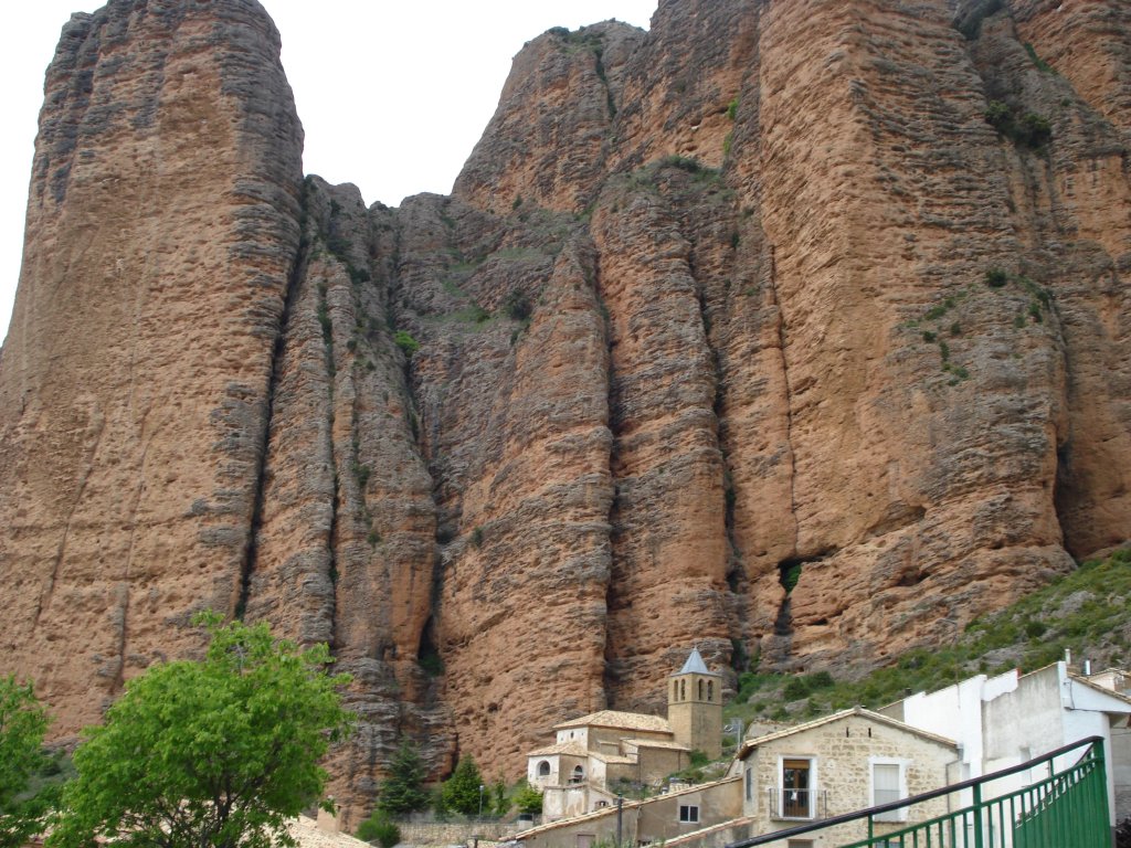
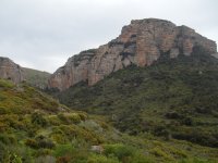
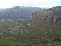
The second Stage of this Nature Trail of La Hoya de Huesca runs between the towns of Riglos and Loarre (municipalities of Las Peñas de Riglos and Loarre), with part of the route coinciding with the GR-1. On this trail, you can see the best views of the mallos of Riglos, of the valley of the River Gállego and of La Hoya de Huesca, as well as discovering two of the most important mediaeval castles in Aragón, that of Marcuello, which is currently in ruins and, in the vicinity of the trail, that of Loarre, regarded as one of the best preserved in Europe.

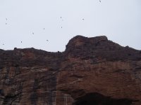
This Stage of the Nature Trail leaves from the town of Riglos, taking a steep street next to the old, now renovated public washhouse, which leads as far as the square and the top part of the village. Here, the trail turns to the right and carries on along a narrow street until it comes to an informative panel on mallos, at the village’s exit. From here, the verticality of these reddish conglomerate walls, with a height of over 300 m, which rise above the small village built on the hillside, is breathtaking. Worthy of note is the outline of the chapel of Nuestra Señora del Mallo, at the foot of these formations that are so characteristic of La Hoya de Huesca, whose reddish tones due to ferruginous materials are enhanced even more at dawn.
The trail leaves Riglos along a dirt track and a few metres further on it turns leftwards along a path signposted with signs for the GR-1 path, which ascends among crop fields and olive trees (Olea europea).
A little further on, on your left, you come to a turn-off from the circular path of the mallos. The Nature Trail continues next to a small pond of water, until you reach a turn-off that leads to the Bird Interpretation Centre of Arcaz, engaged in the dissemination and knowledge of birds in the Kingdom of the Mallos, which, in addition to featuring a glass viewpoint for bird watching, takes charge of organising different bird study activities for adults and children, who can contemplate first hand one of the largest colonies of vultures in Europe.
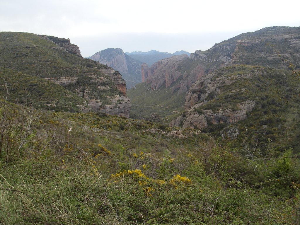
The trail continues straight ahead along a track at the foot of the small mallos (Colorado, Cored, Aguja Roja, etc.), in the direction of the bottom of the valley, with the steep rocky Wall of the Vultures and the mallo of Arcaz on the left and the massif of Os Fils on the right. This massif is a geological formation that is stratified with multiple horizontal layers stacked on top of each other like leaves or sheets, formed by the differential erosion of hard and soft sandstone layers.
The dense cover of kermes oak (Quercus coccifera), box(Buxus sempervirens), rosemary(Rosmarinus officinalis), and juniper (Juniperus communis) which today cover these hillsides, is the result of slow but gradual natural regeneration following the devastating effect of a fire which, in August 2001, razed over 4,300 ha, even forcing the residents of Riglos to evacuate. Once again, nature is showing its recovery power, offering today a picture of great beauty.
If you look upwards, you will undoubtedly see a large number of vultures (Gyps fulvus) and other birds as you are definitely in the Special Protection Area for Birds (in its Spanish acronym, ZEPA) of the Sierra of Santo Domingo and Caballera and the River Onsella and the Site of Community Interest (SCI) of the Sierra of Santo Domingo and Caballera.
The path continues along the track that runs by the side of the ravine of La Mota. It goes around some bends and leaves on the right the turn-off for the path that leads to the via ferrata of Cubilillo, which ascends up to the viewpoint of Los Buitres via spikes. You will now find yourself at the foot of the “Paredón de los Buitres” or the Vultures Wall, which is full of vulture nests where one of the largest colonies in Europe of this carrion-eating bird breed.
The trail continues and narrows, turning into a path at the end of the valley, in the area known as the ravine of Los Clérigos, where kermes oaks, Holm oaks (Quercus ilex), box, gorse (Genista scorpius) and junipers, combined with Scots pines (Pinus sylvestris), offer natural mosaic colouring. After an upward Stage with sporadic railings and wooden steps, the valley begins to open up as does the path that turns leftwards, where another ascending sandstone Stage continues in natural steps and marls, reaching a more open flat area among gorse brushwood, where the path turns into at track.
A few metres further ahead, now on the hillock of Santo Román, you come to an intersection of the paths from where you can contemplate, to the northeast, the valley that leads to La Peña, signposted as the GR-95, with the snow-capped peaks in the background of the Interior Sierras of La Partacua and Tendeñera. Nevertheless, your path continues southwards along the track signposted in the direction of the vantage point, tower and chapel of Marcuello, where you can see how the geology has changed now with a prevalence of grey limestone.
The track makes headway through a brushwood area and ascends slightly. On your right, you can see the summit of the massif of Os Fils and the ravine of Los Clérigos, through which, in the distance, you can contemplate the mallos of Riglos, until you reach the turn-off for the Los Buitres viewpoint. From here as far as the viewpoint, you will have a 1.6 km track, which is worth walking to contemplate one of the best views of the mallos of Riglos and the valley of the River Gállego.
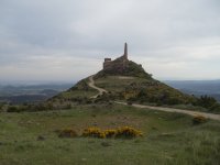
Return to the path and, after 250 m, you will come to the renovated 12th-century, Romanesque chapel of San Miguel, which only conserves its apse. Next to it, there is an informative panel on this interesting mediaeval site, which dominates the Sierra of Loarre, at an altitude of over one thousand metres. From here, the trail takes a detour from the track for 300 m as far as the viewpoint of La Galliguera, next to the chapel of the Virgin of Marcuello and the tower of Marcuello, which formed part of the fortified site of the 12th-century castle of Marcuello, evidencing how these sierras were strategic points for defence and surveillance in the times of the advance of the Kingdom of Aragón.
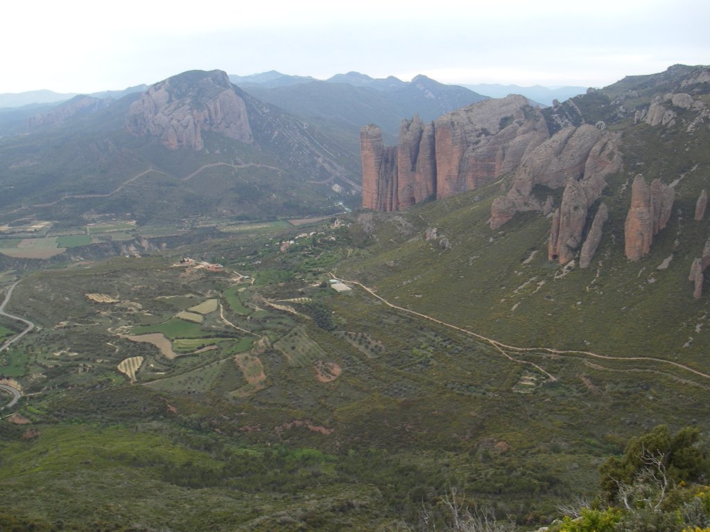
At the viewpoint, you will find several interpretative panels and spectacular views of the south face of the massif of Os Fils and of the part of the valley of the River Gállego, known as La Galliguera, between La Peña and Biscarrués, offering a broad view of the region of La Hoya de Huesca. The outline of this castle is visible from a large part of the region, which is a true visual reference for its people.
Returning back to the turn-off, the trail once again heads in the direction of Loarre, abandoning, at this point, the route of the GR-1, in order to reach, in approximately one kilometre, the next turn-off, where the Nature Trail continues towards the left, leaving on the right the track that leads towards the village of Sarsamarcuello, located 3 km away.
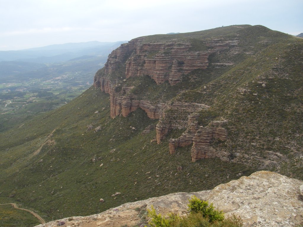
Under the limestone crests of the Peña del Sol on the left of the trek, the path carries on in an easterly direction along the southern side of the Sierra of Loarre, where the initial part of the track is surrounded by an afforestation of black pines (Pinus nigra), with developed undergrowth of box and other brushwood.
In this area, as in a large part of the Pre-Pyrenees, the autochthonous forests of gall-oak (Quercus faginea), normally associated with humid, shady areas, were used far too much for firewood, so many of the forests even disappeared. Those that were afforested with black pines were part of these areas although, due to the loss of the soil’s fertility, in many areas there is a predominance of box and gorse brushwood. Nevertheless, Holm oaks (Quercus ilex) fill the lands that are sunniest and driest.
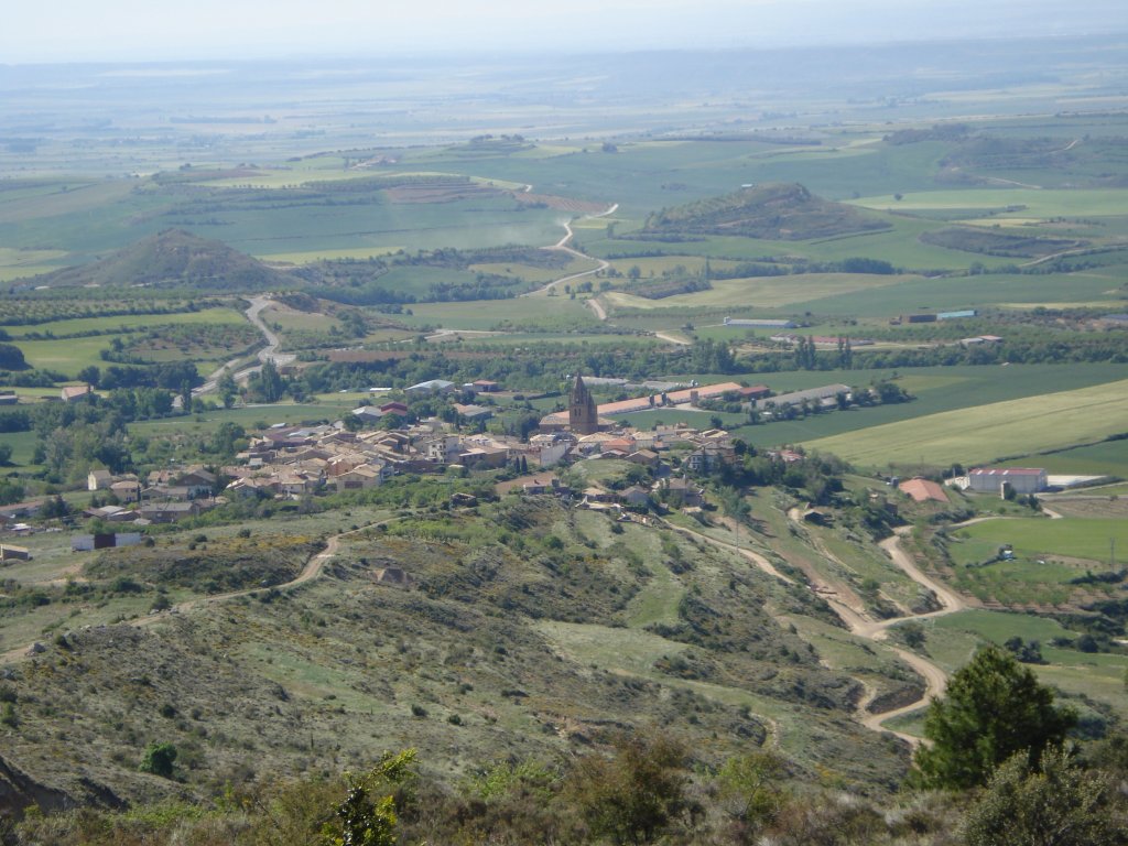
From the clearings offered by the woodland, you can contemplate, on the right-hand-side of the path, beautiful views of the region of La Hoya de Huesca, which is covered with extensive crops and grooves formed by numerous riverbeds and strewn with villages with a great cultural tradition.
After a Stage that descends lightly down the side of the ravine of Layán, you pass by a small cattle grid and, in approximately 1.5 km, in the shade of the ravine of Palangás, you enter an area known as the Cajigar or Cachicar. Here, the path turns to the right, turning into a lovely, narrow path that makes its way between one of the best preserved gall-oak (known as cachico in Spanish) forests in the Pre-Pyrenees area, where, moreover, other species such as field maple (Acer campestris), Montpellier maple(Acer monspessulanum), bearberry(Arctostaphylos uva-ursi), butcher’s room (Ruscus aculeatus) and common hawthorn (Crataegus monogyna) can be found.

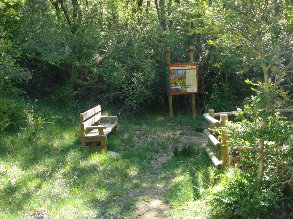
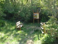
After crossing a small stream via some stepping stones, you once again come to the wide track, which you will leave in some 200 m, this time on the left, to walk again under the shade provided by these magnificent forests, which constitute the perfect habitat for many animals such as the boar(Sus scrofa), the roe deer(Capreolus capreolus) and the red squirrel (Scirus vulgaris), and a variety of birdlife with species such as the common wood pigeon (Columba palumbus), the sparrowhawk (Accipiter nisus), the jay (Garrulus glandarius) and the common blue tit (Parus caeruleus). In 300 m, the path crosses the track to descend a really easy walk as far as the fountain of San Damián, where trekkers will find an informative panel and a small bench to rest on and refresh themselves in the shade of the trees, listening to the tinkling of the bells of the cattle that is peacefully grazing in the nearby meadows.
Carry on walking and, after leaving on the right the PR-HU-96 path, your trail once again turns into a wide track, which now continues through an area of brushwood as far as the ravine of Calderillas. Here, the path takes a southerly direction and heads downwards along the left-hand-side watershed of the eroded ravine in the direction of the town of Loarre.
If you turn your eyes to the left, you can contemplate, perched on a rocky outcrop, the impressive castle of Loarre, one of the jewels of Aragonese Romanesque architecture and declared a National Monument.
The track descends down the hillside until, after leaving a path on the left and passing through some almond tree fields, it reaches the first houses in Loarre.
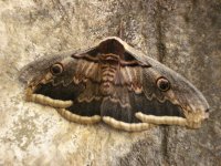
By following the directions, you will come to the square of Moya, where you will discover excellent examples of Aragonese Renaissance architecture in the old 16th-century inn, sturdy stately homes and the nearby church of San Esteban, with a characteristic Gothic capitel. Next to the square, there is a Renaissance fountain, which produces undrinkable water. It was built in ashlar stones with a flattened rounded archway where, if trekkers are lucky, they can see, perching on its walls, a specimen of the largest night butterfly in Europe, the Giant Peacock Moth (Saturnia pyri).
Map
Puntos de Interés
Hidrografía
Información
Infraestructura
Vegetación
Profile
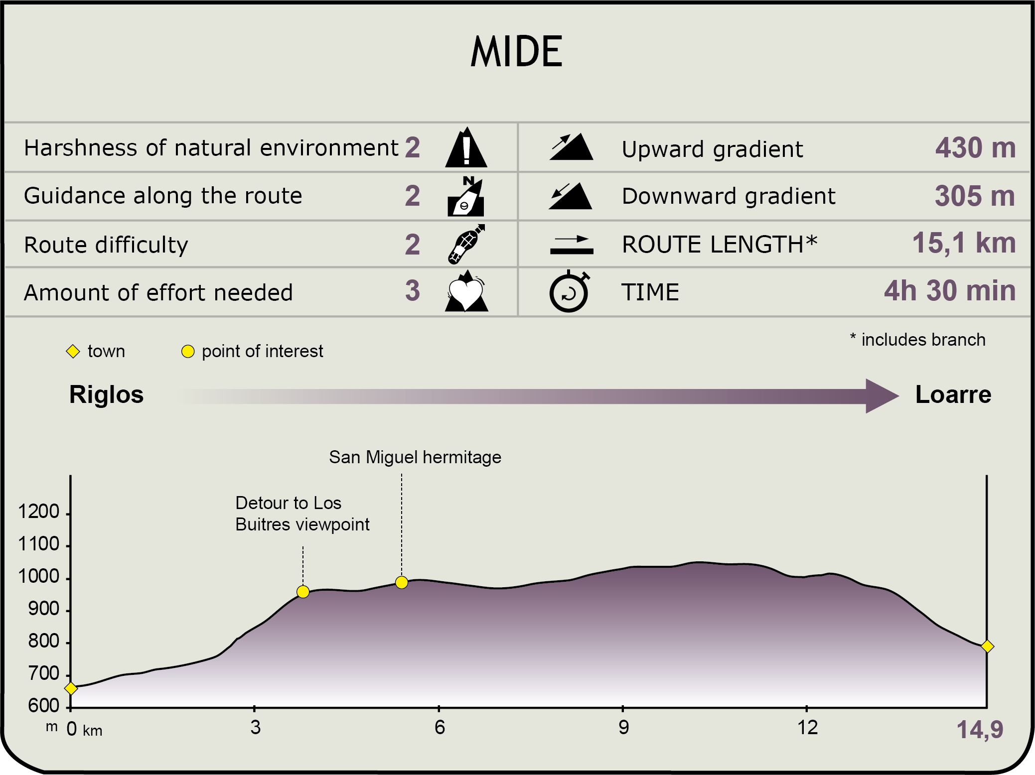
MIDE (Method for the Information of Excursions)
 Harshness of natural environment
- 1. The environment is not risk-free
- 2. There are more than one risk factors
- 3. There are various risk factors
- 4. There are quite a lot of risk factors
- 5. There are many risk factors
 Guidance along the route
- 1. Well defined trails and crossings
- 2. There is a clearly marked trail and signage
- 3. Requires the identification of geographic features and cardinal points
- 4. Requires off-path navigation
- 5. The trail is interrupted by obstacles that have to be gone around
 Route difficulty
- 1. Walking on a flat surface
- 2. Trails with different types of path
- 3. Walking on stepped paths or irregular terrain
- 4. The use of hands or jumping over the terrain is necessary
- 5. The use of hands is required to progress
 Amount of effort needed
- 1. Up to 1 hour of continuous walking
- 2. Between 1 and 3 hours of continuous walking
- 3. Between 3 and 6 hours of continuous walking
- 4. Between 6 and 10 hours of actual walking
- 5. More than 10 hours of continuous walking
Featured
Further information
Os fils and the Castle of Marcuello
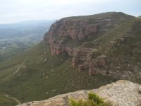
Between the villages of Linás de Marcuello and Riglos, there stands the massif of Os Fils, an unusual formation of rocky cliffs, comprised of stacked leaves or sheets (Fils), which produce a beautiful landscape.
The origin of this formation lies in the differential erosion that occurred in the different layers of harder rock positioned on top of layers of softer rock. These hard strata or layers that are interspersed between the soft layers result in its final stacked sheet appearance.
The upper part of the massif is a kind of relatively flat plateau located at an altitude of one thousand metres, whose level is significantly different to that of the cliffs surrounding it and which dominate the Sierra of Loarre. In the middle in this location there stands the castle of Marcuello, which is currently in ruins.
The castle of Marcuello formed part of a chain of mediaeval fortresses created on the southern border with the Muslim territories of Huesca and Barbastro. Initially, around the 11th century, it belonged to the ephemeral Kingdom of the Mallos, together with Loarre, Agüero and Ayerbe, and a little later formed part of the Crown of Aragón of Alfonso I the Warrior in the first half of the 12th century. The structure, similar to other fortresses in La Hoya de Huesca, was formed of a large rectangular plan tower, in this case with four heights, surrounded by a walled enclosure.
At the present time, the sole elements that have been preserved are the western wall of the tower and the church of Nuestra Señora de Marcuello, a Romanesque temple that was renovated in the 17th century. It undoubtedly already formed part of the fortified site with its strongly defensive looking tower-belfry and its semi-circular apse, under which a crypt dedicated to San Esteban lies.
The western end of the castle is the location of the viewpoint of the Vultures, which is home to one of the best views of the mallos of Riglos, Peña Rueba and the valley of the River Gállego, and the mallos of Agüero can even be seen in the distance.
From here, you can see even more closely the Wall of the Vultures, which is a nesting place mainly for the griffon vulture (Gyps fulvus) in addition to other birds of prey, such as Egyptian vultures (Neophron percnopterus) and bearded vultures(Gypaetus barbatus) which are also common in this area.
In order to access the viewpoint, there is also a via ferrata (known as Cubilillo) which has been recently outfitted and ascends the western face of the massif. It has become one of the most popular due to its moderate difficulty, excellent views and lush vegetation.
Close to the remains of the castle, you will find the chapel of San Miguel, which also dates back to the 12th century and, although it has been restored, it conserves its original apse covered with a quarter sphere and a barrel vault.
Multimedia