- Home
- Rural Development
- Nature Trails
- Nature Trails
- Northeast Sector
- Ruta del Glorieta
River Glorieta Nature Trail
Description
Through the Mediterranean forest, among ancient mills and natural fountains
El Glorieta Nature Trail covers the highest part of the valley of the River Glorieta, running between Mas de Forès, in the municipality of Alcover, and Mont-ral. The way in which the river has been used over time becomes apparent along the route through the remains of old buildings that can still be seen, such as hydroelectric power plants, mills and water channels. The Valley of the River Glorieta is a natural space of enormous scenic value, characterised by a thick Mediterranean forest alternating with rich riverside vegetation between pools, grottos and spectacular waterfalls.
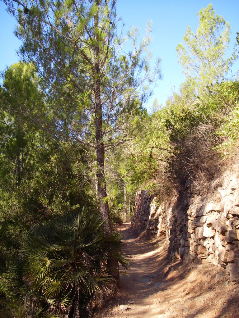
In order to reach the path’s starting point, you have to take a narrow road from Alcover to the chapel of El Remei. When you get there, you should continue along an asphalted path that leads to the old paper mill of El Mas de Forès, where there is a visitors’ car park. At this point, there is an informative panel that marks the beginning of the route at a dirt track on the right of this panel. Some 500 m from the beginning, you come to a junction where the three routes that can be completed along this Nature Trail meet: the Royal Path (camí ral) from Alcover to Mont-ral, on the right; El Glorieta Mill Path (camí del molí), on the left; and the Path of the Mas de Forès Canal (camí de la sèquia) in the centre.
The Royal Path from Alcover to Mont-ral

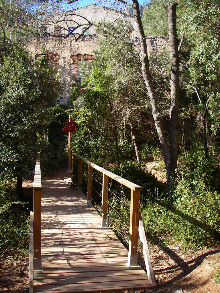
This is a very long and demanding route. Along its almost 6 km, it climbs the River Glorieta along its left bank as far as Mont-ral, coinciding with the route of the Albiol-Cogullons trail (PR-C 20), passing through very steep areas with uneven surfaces, which discourages cycling, especially over the last 3 km. From kilometre 1 of the route, the track changes into a path that forges its way through dense vegetation characterised by coastal Holm oak and secondary pine woods, with Holm oaks (Quercus ilex), gall-oaks (Quercus faginea) and white pines (Pinus halepensis) as dominant species, as well as diverse riverside vegetation in the dampest areas. You can also see specimens of Mediterranean dwarf palms or fan palms (Chamaerops humilis), included in the catalogue of regional protected species. Further ahead, after crossing a wooden walkway, you can contemplate the ruins of Mas de l`Estamanyer. The path, which is not very difficult in this section, continues to climb the valley across a sunny hillside, leaving on the left-hand side, around kilometre 2.6, the remains of the mills of El Glorieta. Once you have crossed the Ravine of La Nevera, thanks to another walkway, you come to the ruins of El Glorieta Hydroelectric Plant, which used the river’s waters to supply Alcover and La Selva del Camp with electricity until the 1940s.
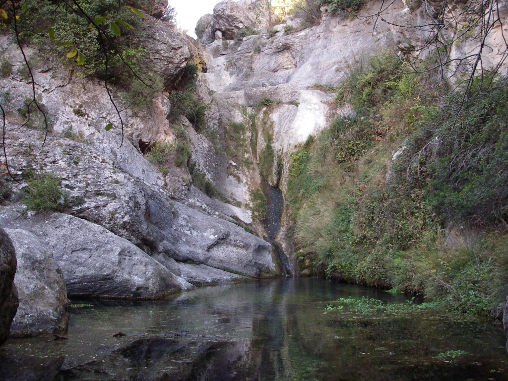
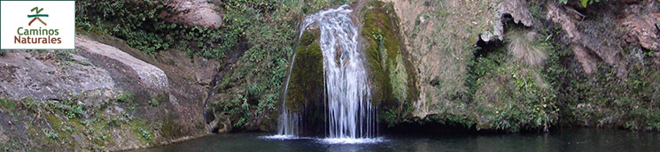
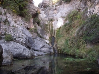
A stepped part on the right of the power plant allows you to climb down to a small esplanade where part of the aqueduct that took the water from the reservoir, located one kilometre upstream, as far as the power plant, is still preserved. On the left, under the arches of the aqueduct, a trail emerges that leads to a spot known as the Nido del Águila, or the Eagle’s Nest, one of the most beautiful and popular places in the valley, where trekkers can enjoy its crystal clear pool, surrounded by rocks and dense riverside vegetation, such as willows (Salix atrocinera), hoary willows (Salix eleagnos) and ash trees (Fraxinus angustifolia).
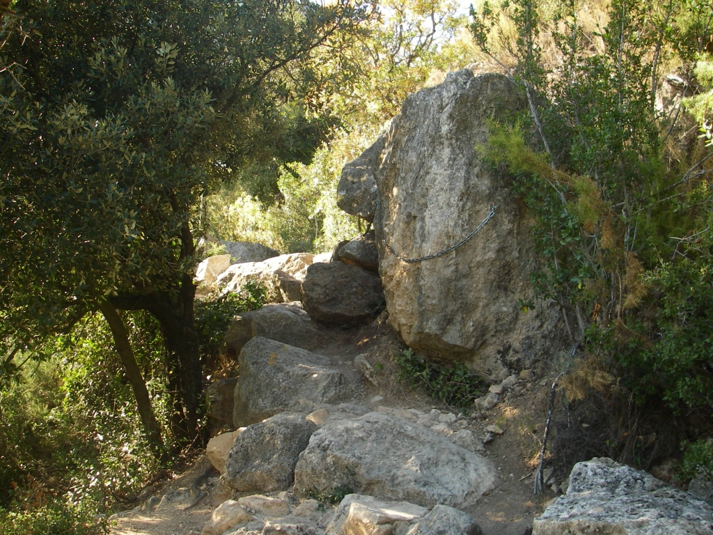
From this point onwards, the path becomes very winding, with considerably steep parts and an uneven surface, which makes cycling to the end of the route unadvisable. After easily crossing a small pass with chains on the rocks, you come to a rest area next to an old collection reservoir, where part of the channels that took the water to the power plant remain. On the left, another small path emerges that enables you to enjoy the river once again with spectacular views of the valley.

The slope becomes tougher once again, until it reaches a vantage point containing an explanatory panel of the landscape that trekkers leave behind them. This viewpoint is located above the source of the River Glorieta (fonts del Glorieta), which can be accessed via a sign-posted path on the left a few metres before the viewpoint. Numerous aquatic plants, such as Rorippa nasturtium-aquaticumand Apium nodiflorum, appear in places where water is constantly present throughout the year.
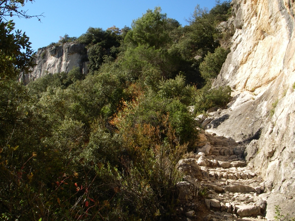
The route continues gaining height by means of a stepped section excavated at the foot of a limestone formation known as the "Cingles (crags) del Glorieta". The path’s toughness is offset by the rich landscape that accompanies trekkers along this ascending section, allowing them to contemplate one of the numerous hollows caused by the water’s erosive force. The toughest part of the route is over, and trekkers can take a last glance behind them to ensure that a beautiful picture of the path they have just covered is engraved on their minds.
From here, you can see how the dense forest mass that covers the entire valley is accompanied by rich undergrowth with an abundance of species such as: box (Buxus sempervirens), kermes oak (Quercus coccifera), strawberry tree (Arbutus unedo), mastic tree (Pistacia lentiscus), turpentine tree (Pistacia terebinthus) and rosemary (osmarinus oficinalisR), in addition to heathers (Erica multiflora, Erica arborea), laurustinus (Viburnum tinus) and shrubby hare’s ear (Bupleurum fruticosum), and diverse climbing plants such as honeysuckle (Lonicera implexa) and sarsaparilla (Smilax aspera). The dense forest mass is also home to a diverse array of fauna, including numerous specimens of boar (Sus scrofa), badger (Meles meles), pine marten (Martes foina), squirrel (Sciurus vulgaris) and other rodents, in addition to a long list of birds such as Bonelli’s eagle (Aquila fasciata), the green woodpecker (Picus viridis) and the European robin (Erithacus rubecula).
The path soon turns rightwards, on a less demanding climb, reaching a firewall that should not confuse you, as to fully complete this section you need to cross it and continue straight ahead until you reach an unsignposted concrete path that you must take on your right. In a few metres, a well signposted path indicates the beginning of the section most marked by humans on this route, where ordered crops appear, mainly hazelnut trees.
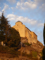
A hazardous crossing sign warns you of your arrival at one of the streets in the municipality of Mont-ral. Taking advantage of the street’s layout, you come to the TV-7045 highway, at whose intersection you should pay special attention to the road traffic. Once you have taken the road on the left, via a path on the right, trekkers now face the last part of the path as far as the end of the route, where you can freshen up in a drinking water fountain next to the panel that marks the end of the route. Furthermore, in Mont-ral, you can also contemplate pretty views of the region of Alt Camp from the church of Sant Pere ad Vincula, whose main structure and façade are Romanesque in style and which was restored in the 18th century, the date when the bell tower was built.
Path of El Glorieta mill
This is a simple 6 km route, which, leaving from Mas de Forès, coincides with the Royal Path from Alcover to Mont-ral as far as the power plant walkway. Once you are there, you need to take a turn-off on the left, crossing the River Glorieta via a simple natural stone pass. The path enters land belonging to the private estate known as Mas de Mario, where ruins of the El Glorieta mills still remain. A metallic fence next to the path will remind trekkers that they are crossing a private area that they must respect. After leaving this property through a metallic gate, there is a very large Holm oak next to the path. Some 300 m further ahead, you join the canal path (camí de la sèquia), which is described below. In the surrounding area, where there used to be a field of hazelnut trees that is now occupied by a young pine grove, you can once again enjoy the clean waters of the riverbed, home to the Iberian river crab (Austropotamobius pallipes lusitanicus), a protected species in recovery.
Further on, the track crosses the river in an area where you will have to take care in flood season. Trekkers can easily reach the path’s starting point next to the Mas de Forés car park, the end of the route.
The Mas de Forès canal path
This is a short circular route measuring 2.5 km, which leaves from the Mas de Forès car park and heads towards the canal rest area. This narrow path, which passes by its eponymous canal, with wooden or stone steps built across it, allows you to enjoy a practically flat route among the valley’s typical vegetation. Once you have crossed the River Glorieta, the path joins the route of El Glorieta mill path, sharing the final section as far as the Mas de Forès car park.
Sites of interest
Profile
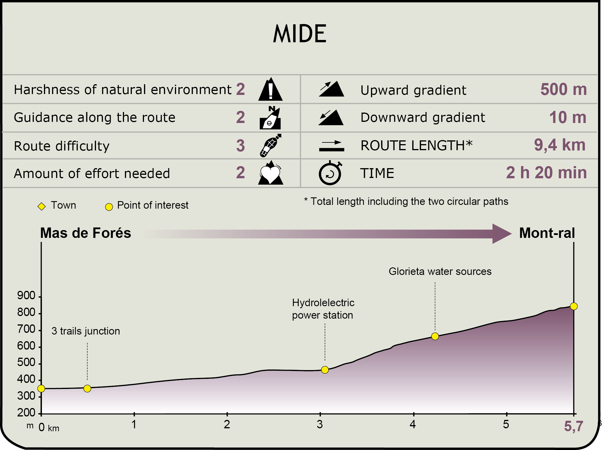
MIDE (Method for the Information of Excursions)
 Harshness of natural environment
- 1. The environment is not risk-free
- 2. There are more than one risk factors
- 3. There are various risk factors
- 4. There are quite a lot of risk factors
- 5. There are many risk factors
 Guidance along the route
- 1. Well defined trails and crossings
- 2. There is a clearly marked trail and signage
- 3. Requires the identification of geographic features and cardinal points
- 4. Requires off-path navigation
- 5. The trail is interrupted by obstacles that have to be gone around
 Route difficulty
- 1. Walking on a flat surface
- 2. Trails with different types of path
- 3. Walking on stepped paths or irregular terrain
- 4. The use of hands or jumping over the terrain is necessary
- 5. The use of hands is required to progress
 Amount of effort needed
- 1. Up to 1 hour of continuous walking
- 2. Between 1 and 3 hours of continuous walking
- 3. Between 3 and 6 hours of continuous walking
- 4. Between 6 and 10 hours of actual walking
- 5. More than 10 hours of continuous walking
Featured
Further information
The chapel of Remei
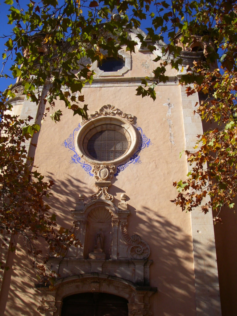
This temple is located on the eastern hillside of the mountains of Prades, on the left bank of the River Glorieta. Due to the town of Alcover’s great devotion to the Virgin of Los Remedios (Mare de Déudel Remei) and local economic splendour, the decision was taken to build a chapel over an old 16th-century temple dedicated to Saint Antonio Abad.
The current sanctuary was built by the Town Hall and the neighbours between the years 1761 and 1772, as is recorded on the façade crowning moulding, which was blessed in 1779. Its Baroque facade, where there is a niche containing the image of San Antonio and an octagonal rose window, flanked by two circular towers, is worthy of note. Next to the chapel, you will come across the house of the hermit that cared for it, which has been refurbished and currently serves as a restaurant.
The chapel of El Remei has always received frequent visits not only for religious reasons. During the Fira del Remei, which is held in October, people come to venerate and offer flowers to the virgin, and it is a place chosen by many couples in the area for their weddings.
Paper mills and Mas de Forés
In the past, the Valley of the River Glorieta was a basic cornerstone of the local economy thanks to the river’s use as a power source; hence, it has been catalogued as a site of local historic-cultural heritage. In the 18th and 19th centuries, the paper industry became a driving force in the area’s economy, with the existence of up to 10 factories driven by the River Glorieta’s waters, which transformed rags into different types of paper, such as shiny white and brown paper.
The Mas de Forés estate, which occupies an area of 102 ha, had three of these mills whose buildings can still be seen on the estate. Several locks along the river collected the water, which was transported to the factories that finally used its power for the paper industry through a channel and canal network. Next to the mill, located at the top, there still remains a small aqueduct that supplied the mill with water. Since 2001, the estate has belonged to the town council of Alcover, and has picnic and games areas in addition to diverse informative panels on the valley’s fauna and flora in a peaceful spot surrounded by vegetation.
Multimedia