Stage 8: Puente Arenas - Trespaderne
Description
This Section begins at the bridge (570 m). Following the signs to the shrine of San Pedro de Tejeda, 900 m from the village, the route heads down to the east along the road to Cubilla. The path merges with a track that comes from the road and climbs up Tesla Mountain Range. It heads towards BU-V-5314 that traverses the valley amidst fields. Immediately after, the route turns onto another track to the right that runs parallel to the Ebro and leads to the town of Valdivielso (5.4 km, 1hr 15min).
Heading out of the town to the south, the route crosses a picnic area along the Ebro. The path continues along the river to Ventillas Bridge that leads to the N-232. After crossing the BU-V-5314, the route runs along the left bank until it veers onto a track to the left, and then right, downstream along the Ebro. It crosses a brook near a picnic area, before crossing the new bridge.

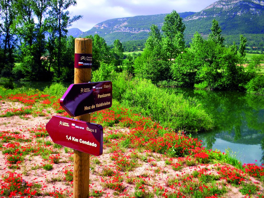
From here, the route heads towards Condado, along the right bank of the Ebro, but a detour to Cereceda y Panizares Reservoir is well worth the effort. To do this, the route heads left from the bridge through woodlands until Calentura Spring, where it crosses a bridge and continues to climb up and down until Fuente Sagrero Cave. Past another pine forest, the path comes upon the BUV-5314. The route now descends to Panizares Bridge over Cereceda Reservoir (12.4 km, 2hr 40min), a site of huge ecological value, with slopes carpeted with vegetation and a rich diversity of fauna. The route climbs up Panizares (665 m) along a stretch of the road. Soon after crossing the bridge, a track to the right leads into the town, home to Cuchillos de Panizares on the northern slopes of Sierra de la Tesla, very sharp rock monoliths of whimsical shapes, frequently covered with mist and fog; the typical image of this area.
The track leading to Hoz de Valdivielso (16.3 km, 3hr 40min) starts in the lower part of the village, and ends after one kilometre. The route continues through oaks, boxwood and pines, next to a fence that must be traversed to climb down to the ravine.
The route crosses the town along Calle Real and joins the road that climbs to Tartalés de los Montes, heading upstream along the namesake river. A forest trail starts here in a southeast direction along the Borcos Ravine watershed.
The Ebro Nature Trail winds through grazing lands surrounded by pines and oaks, past La Laguna country estate, and disregards several paths on both sides of the Trail, until it reaches Corral de Pedraco, where huge boulders form a sheepfold. The route crosses a brook and climbs up through a pine forest to Muñeca Hill (940 m), the boundary between Tartalés de los Montes and Tartalés de Cilla, whence the Siete Cruces boundary marker (1,163 m) and the summit of Tesla Mountain Range (1,170 m) can be seen. The Trail now ventures into Montes Obarenes-San Zadornil Nature Park.

From here, the route descends to the town of Tartalés of Cilla (25.7 km, 6hr 10min), situated parallel to the left bank of Torcas Brook. It continues along the street where the church is located, leaves behind the town, and continues towards the fields around the end of Horadada Gorge (included in the Montes Obarenes Nature Reserve). This twelve-kilometre limestone gorge, covered in oak and cluster pine, is inhabited by raptors, wild boar, roe deer, foxes, griffon vultures and sparrow hawks.
Leaving Cereceda/Trespaderne channel behind, the path climbs down to N-629 leading to the town of Trespaderne, nestled in Horadada Gorge. The route passes under the Santander-Mediterráneo railway bridge and reaches Valdecastro Bridge (link to Section 9.1). Soon after, it ventures into an industrial park and reaches the medieval bridge and landscaped zone leading to N-629 (535 m, 28.9 km, 7hr).
Sites of interest
Profile
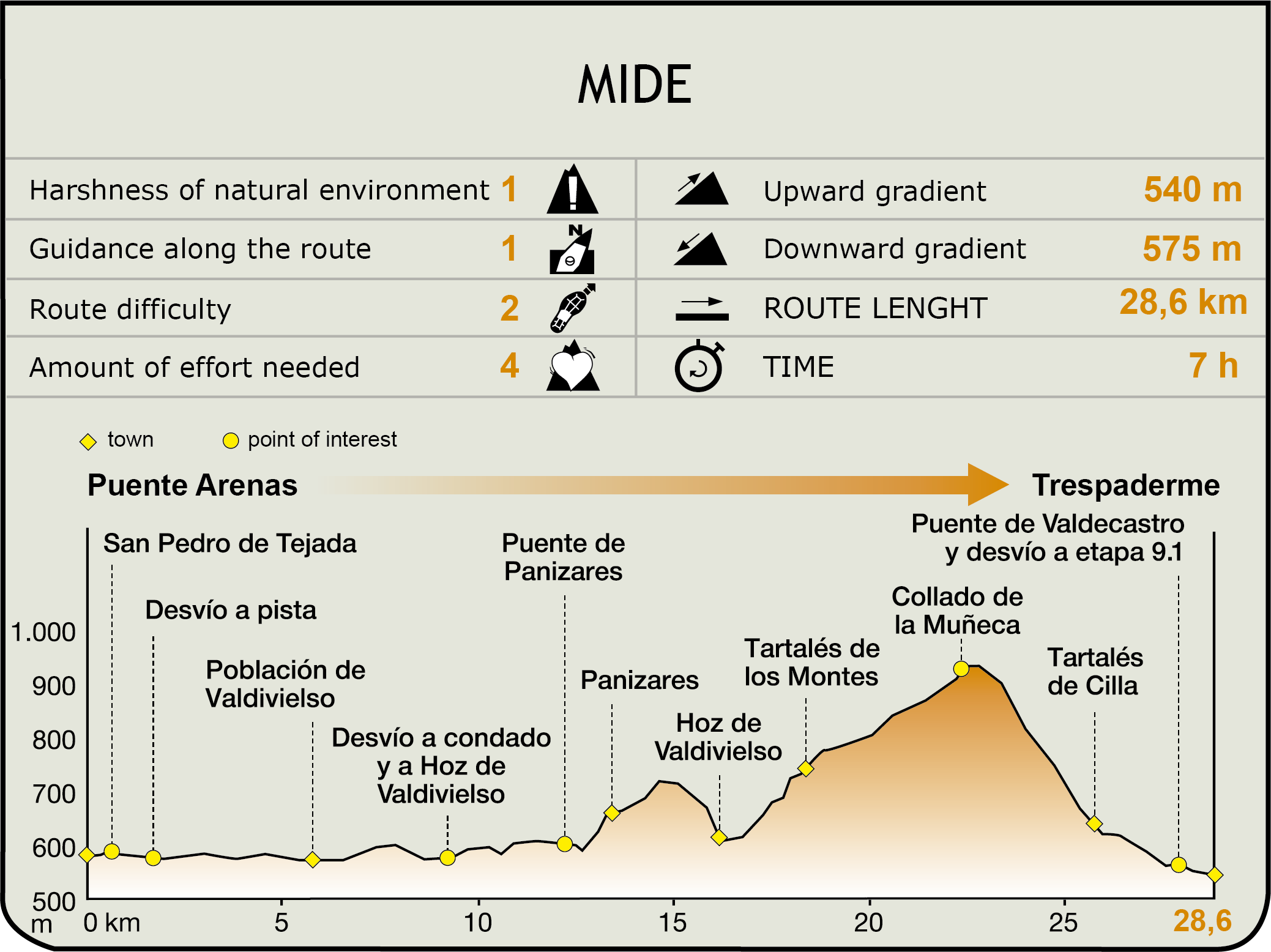
MIDE (Method for the Information of Excursions)
 Harshness of natural environment
- 1. The environment is not risk-free
- 2. There are more than one risk factors
- 3. There are various risk factors
- 4. There are quite a lot of risk factors
- 5. There are many risk factors
 Guidance along the route
- 1. Well defined trails and crossings
- 2. There is a clearly marked trail and signage
- 3. Requires the identification of geographic features and cardinal points
- 4. Requires off-path navigation
- 5. The trail is interrupted by obstacles that have to be gone around
 Route difficulty
- 1. Walking on a flat surface
- 2. Trails with different types of path
- 3. Walking on stepped paths or irregular terrain
- 4. The use of hands or jumping over the terrain is necessary
- 5. The use of hands is required to progress
 Amount of effort needed
- 1. Up to 1 hour of continuous walking
- 2. Between 1 and 3 hours of continuous walking
- 3. Between 3 and 6 hours of continuous walking
- 4. Between 6 and 10 hours of actual walking
- 5. More than 10 hours of continuous walking
Featured
Further information
The heritage of Valdivielso and Trespaderne
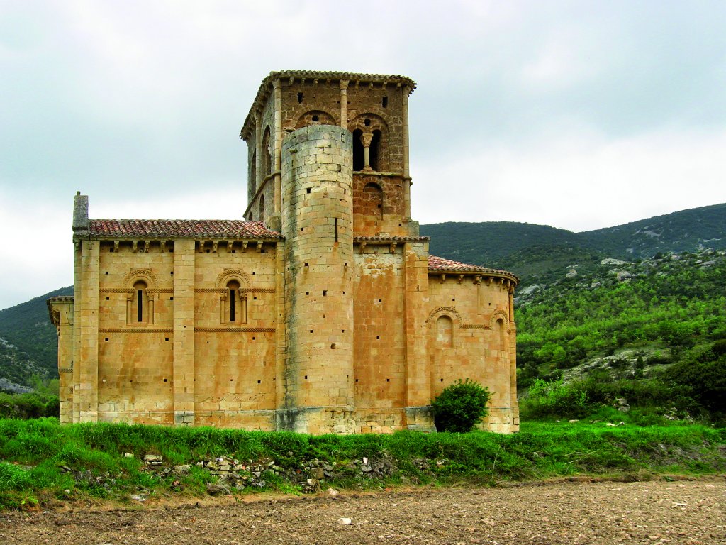
This Section begins near San Pedro de Tejeda, an 11th-12th century Romanesque shrine, and one of the finest examples of this style of art in Valdivielso Valley. The parish churches of Condado and Panizares are also Romanesque. At Hoz de Valdivielso, the church of San Cornelio y San Cipriano (15th-16th C.), the Herreran-style palace of Huidobro (16th C.), and the remains of the 11th century Romanesque shrine of Santa María de las Heras are noteworthy. Tartalés de los Montes has the Romanesque parish church of San Miguel (12th C.). At the edge of the town of Tartalés de Cilla (630 m), to the north of the road, is a sandstone outcrop where the hermit cave of San Pedro was excavated in the 7th-8th centuries. The parish church of San Martín can be traced back to the 12th century.
In Trespaderne, the most remarkable landmarks are the shrine of Virgen de Encinillas, the Priory manor, the palace of Medina Rosales Cadiñanos, the parish church of San Vicente, and the medieval bridge. Outside the town, on a cone-shaped mountain, stands the Castle of Tedeja, atop the walls of the Horadada Ravine. There are magnificent views from this 9th-10th century defensive complex. The shrine of the Portuguese (7th-10th C.) is on the road, before entering Trespaderne.
Multimedia