Stage 40: Benifallet - Tortosa
Description
The old Val de Zafán railway line
If you retrace your steps from the end of stage 39, you will cross the Llaguter bridge and you will descend to the bank of the Ebro before continuing along the C-12 road as far as the Canaletes gorge, which you then climb to reach the old Benifallet railway station. The route of the Baix Ebre Nature Trail is used here to cross three gorges by two viaducts, to access the Xerta weir and later this town itself. You will then reach the Aldover orchard (which boasts the largest river beach on the Ebro) After passing Roquetes, where the Parc Natural dels Ports interpretation centre is, you cross the Iron Bridge and finish at Tortosa.
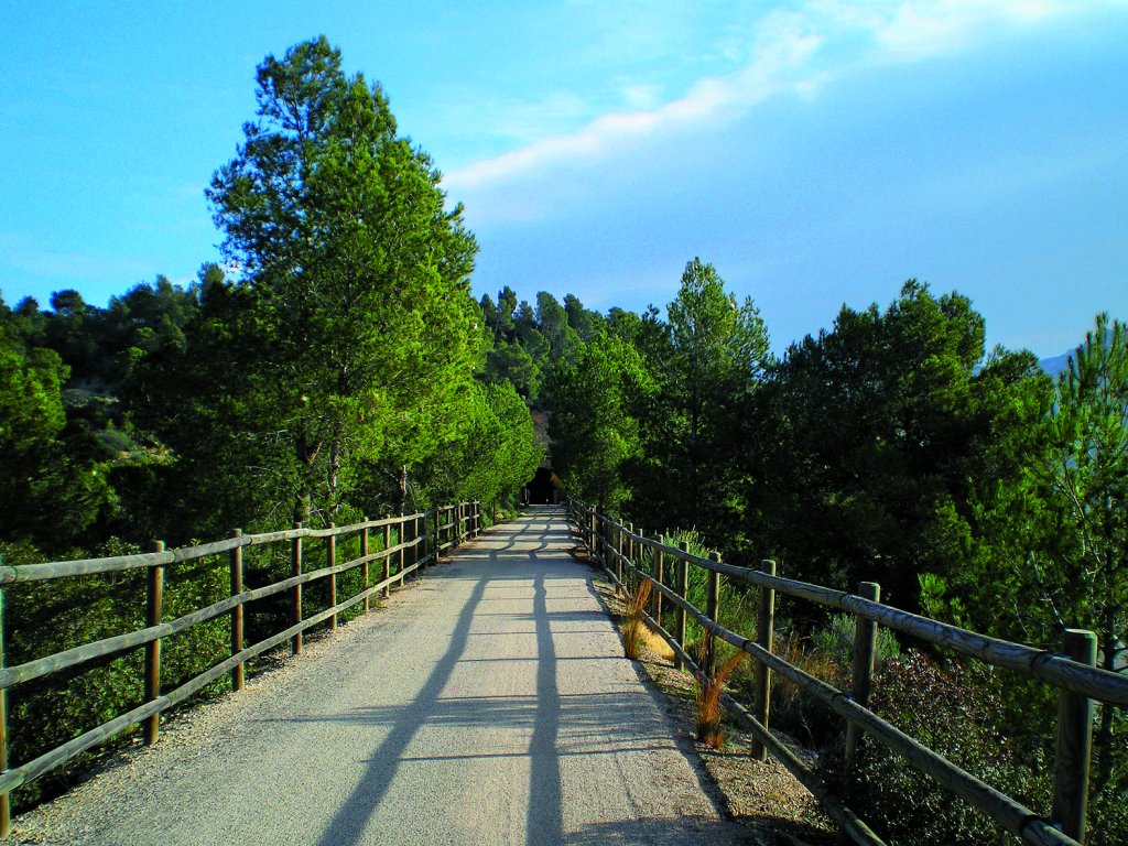
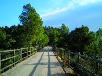
Before beginning, you must retrace the last section of stage 39, cross Llaguter bridge and descend by a path on the right until you go under its support. Once you have reached the bank of the Ebro, continue south-west, passing the access to the old boat crossing and coming out again at the C-12 road. You will have to follow it, as the GR 7 does, for 1.5 km, until you reach the mouth of the Canaletes gorge. At this point, leave the road and the GR 7 behind and take the path on the right to climb up the left bank of Canaletes. Further on, the road allows walkers to cross the normally dry riverbed and ascend a leafy hillside until they reach the old Benifallet railway station, which belonged to the former Val de Zafán railway line, now restored as the Vía Verde de la Val de Zafán Nature Trail (Baix Ebre Section).
Several tunnels will welcome the traveller on this first section of the route, so it is always recommendable to carry some kind of illumination to cross it comfortably. The nature trail quickly cuts into the hillside between trenches and passes through three tunnels before reaching the viaduct over the Els Frarers gorge, which offers spectacular views.
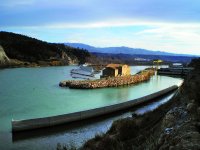
After traversing two new tunnels, you will reach the Mas de Xalamera. After it, the track enters the longest tunnel, which is almost 470 m long. It will only be possible leave this point after negotiating three short passages, before reaching the broad plain that the Ebro forms near Xerta. Thus, the last wall the Catalan Coastal Range places in the way of crossing the Ebro, which began to be crossed at Ascó, with the Pas de l’Ase, will have been overcome. A new 202 m tunnel precedes a broad area, from which the Xerta weir is accessed. This 300 m-long infrastructure provides water to irrigate the entire Ebro Delta. It was built in the 12th century and permanently laid out in 1411. In the mid-19th century, it was reinforced with a lock for navigation by steamers, barges and raft, and the canal on the right by the Real Compañía de Navegación (Royal Navigation Company). The only on the left was opened in 1912. Today, an attractive refurbished lock allows small pleasure craft to pass.
The path continues and excavates a last 73-metre tunnel before reaching the station and town of Xerta, a place of orange trees, with an interesting limnograph on the façade of its parish church, which narrates the historic floods of the Ebro the town has suffered.
Crossing the C-12 ring road, it begins to pass through the orchard in Aldover, a village with the largest river beach in the Lower Ebro and which is reached easily by skirting the village to the west. The path continues south and passes a large medieval Corder tower. The old Ibero-Roman river lighthouse visually connected with the Suda de Tortosa and La Campana de Xerta towers (which disappeared in the 1930s). Opposite it, the island of Audí, a protected enclave because of its riverside ecosystem within the Illes de l’Ebre Pla d’Espais d’Interès Natural.
Further on, after crossing a straight stretch with different side accesses to the various neighbourhoods of Raval de Jesús (a district of Tortosa), you will reach Roquetes. The town centre is home to the Parc Natural dels Ports Interpretation Centre and, on the outskirts, the important Ebro Observatory, which was founded in 1904 by the Jesuits for meteorological, climatic and especially seismological observations. From here, the bend in the old railway line takes the traveller into Tortosa and, shortly after crossing the iron bridge, this stage ends.
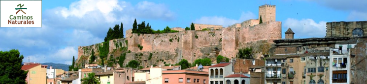
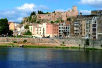
Tortosa, perched on the hill overlooked by the Arab La Suda Castle, is the capital of the Baix Ebre district; it has just over 50,000 inhabitants. It has also been an episcopal see and a major communications hub since its foundation. A 7th century BC document indicated that Tortosa (Dertosa) was a very rich city, since it controlled all the trade between the sea and the fertile valley of the Ebro. It had docks and quays that dispatched cargo upriver in shallow-draft riverboats and, on the seaward side, it received goods with ships of greater draught.
Profile
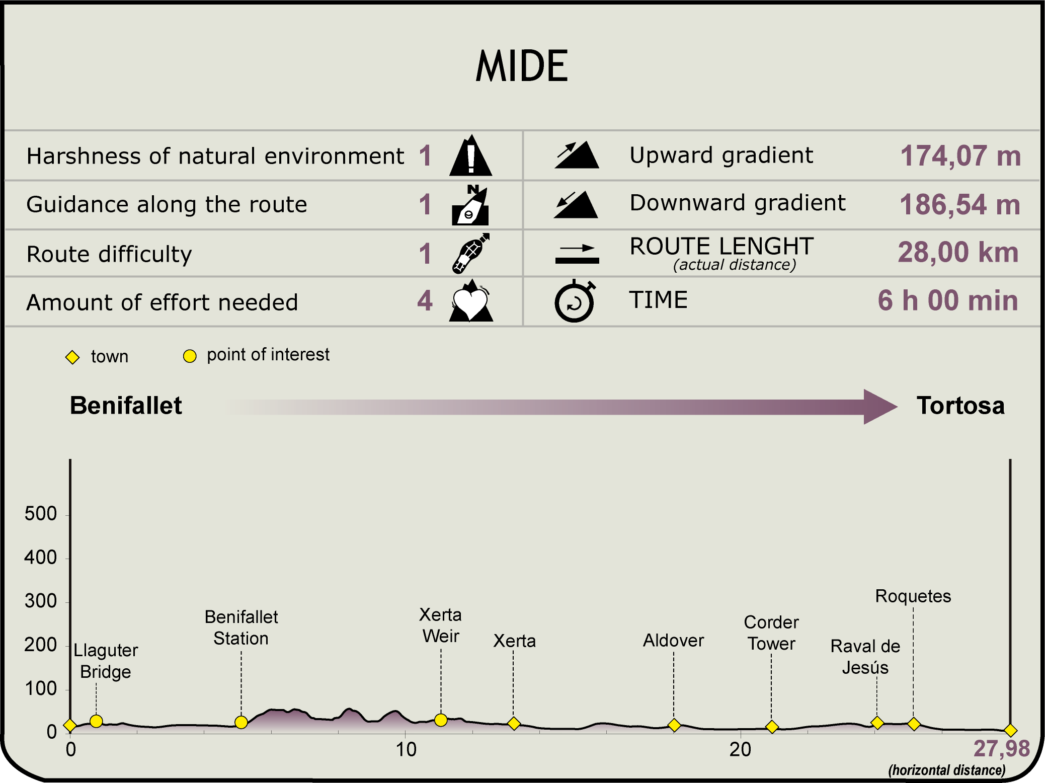
MIDE (Method for the Information of Excursions)
 Harshness of natural environment
- 1. The environment is not risk-free
- 2. There are more than one risk factors
- 3. There are various risk factors
- 4. There are quite a lot of risk factors
- 5. There are many risk factors
 Guidance along the route
- 1. Well defined trails and crossings
- 2. There is a clearly marked trail and signage
- 3. Requires the identification of geographic features and cardinal points
- 4. Requires off-path navigation
- 5. The trail is interrupted by obstacles that have to be gone around
 Route difficulty
- 1. Walking on a flat surface
- 2. Trails with different types of path
- 3. Walking on stepped paths or irregular terrain
- 4. The use of hands or jumping over the terrain is necessary
- 5. The use of hands is required to progress
 Amount of effort needed
- 1. Up to 1 hour of continuous walking
- 2. Between 1 and 3 hours of continuous walking
- 3. Between 3 and 6 hours of continuous walking
- 4. Between 6 and 10 hours of actual walking
- 5. More than 10 hours of continuous walking
Featured
Further information
Val de Zafán Nature Trail
The origins of the Val de Zafán railway lie in the nineteenth century, when it was intended to take agricultural products from Aragon and coal from the Utrillas coal mining area from Zaragoza and Alcañiz to San Carlos de la Ràpita. Financial problems delayed its becoming fully operational - in reality it only reached Tortosa - until 1942. Competition from road transport and the construction of other railway lines made this route economically unviable, and it was permanently closed in 1973. It has been resurrected for recreational use by means of the Vía Verde de la Val de Zafán Nature Trail, which, because of its three sections (Baix Ebre, Terra Alta and Teruel) , makes it possible to travel along this old railway line from Tortosa (Tarragona) to Valdealforfa (Teruel).
Multimedia