
Stage 36.1: Mequinenza - Fayón
Description
Towards the River Matarraña
A path leads from the Mequinenza bridge over the Ebro to the Albera valley. The construction of the Riba-roja reservoir flooded the old traditional paths, making it necessary to ascend the Mas de Borbó plains and continue along the high plateau. After leaving behind numerous scattered houses and the San Jorge hermitage, whose ancient pine tree stands out, a forest path descends to Fayón, a town that was built entirely after the reservoir flooded the historic centre. The path leaves it behind to skirt the spectacular Bugarrech crag and descend to the banks of the Matarraña, where it crosses the bridge before ending at the Pobla de Massaluca/Fayón railway station.
You will begin this new journey from the bridge over the Ebro, where you should take the A-1411 road, towards Fayón. After a few metres, leave the road to the left and continue along an paved path that crosses the Val del Pueblo gorge, which gradually narrows between the steep slope and the calm waters of the river. There are several entrances that you must ignore. Some are on the right-hand side, giving access to the lignite mines, and others on the left-hand side, which will you to continue to a rest area with facilities. After 6.7 km, the landscape widens and opens to a large expanse of fruit orchards, known in the area as L’Albera, which exploits the convex side of a large meander of the Ebro. At the end of the paved path, the road turns south, before crossing two gorges, going under a small residential area and, 300 m further on, after turning left, it rises, leaves and plain and approaches an isolated house. It is opposite the entrance to this house that the path leading up to the plain begins.
To do so, take the path facing the house, which zigzags up a rocky slope and turns southwest until it reaches a watershed. After walking along it for a few metres, it moves back into the shady side of a gorge and crosses a small rocky step before running along the headwaters of this side tributary. Shortly after that, go around the platform where you will begin to see the first crops on the upper plain and, after taking another turn, this time to the left, you will reach a track, beside wide fields.
Continuing along this path, which then heads east, you will cross the cultivated hill before descending to the Mas de Borbó and 500 m beyond that you will emerge at the A-1411 road. Follow it on the left for 1.7 km, first on the right-hand side and then on the left. After this distance, you will reach a wide path, on the left, which leads to a farmhouse. After another 500 m, leave this main path via a track with a poorer surface that leads off to the right, making a 90º turn. This path descends, crosses a gully, turns left and, after crossing an area of fields, ascends to Mas de Jaime. Continue first southwest and then south to reach the CV-103 road.
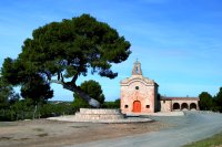
Continue along it for several metres on the left, although you will have to leave it by a path on the right. It turns right and left and then joins a cross path with a better surface to make the hiker’s journey easier. On the left, after crossing a small gully, you will reach the beautiful San Jorge hermitage, an 18th century building. At this point, a well-paved lane begins, which leads off to the east, towards the CV-103 road, which it reaches 1.4 km from the hermitage.
Avoiding the road surface, instead following tracks and paths that run along the right-hand verge, the route continues for 2 km before crossing the road, making a 90º left turn and entering a track that crosses a pine forest. This leads to a watershed, where you should take the path on the right, which runs along the sunny side of the gorge (from the other side of the pass you can see the steep drops formed by the Ferrera gorge towards the Ebro).
The path then skirts a small cirque and, when it begins its descent, in view of the wide valley where Fayón lies, it takes a secondary track on the right, which leads to some warehouses. Next to them there is a path running along the head of a small gorge until it reaches another trail that leads to the aforementioned buildings. Continuing south, without leaving this path, you will reach the cemetery and finally Fayón.
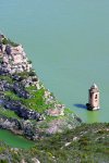
The traveller will have to decide whether to go to the railway station. If you choose this option, you will have to descend to cross the bridge over the Matarraña. To do this, at the southern end of the main street, you will have to take a road that immediately slopes down to the Juanito gorge. This is flanked by the Peña Bugarrech, and reaches the banks of the river which, at this point so near its mouth, has the waters of the Ebro flowing upstream. Another track, in this case on the right, leads to the Z-V-7231, beside the bridge. On the other side, there is a paved path that turns left and leads to the Fayón-Pobla de Massaluca station.
From this point hikers can reach Riba-roja, taking one of the trains that connect stations, and continue with stage 37, towards Flix (downstream) or Almatret and Mequinenza (upstream).
Sites of interest
Map
Profile
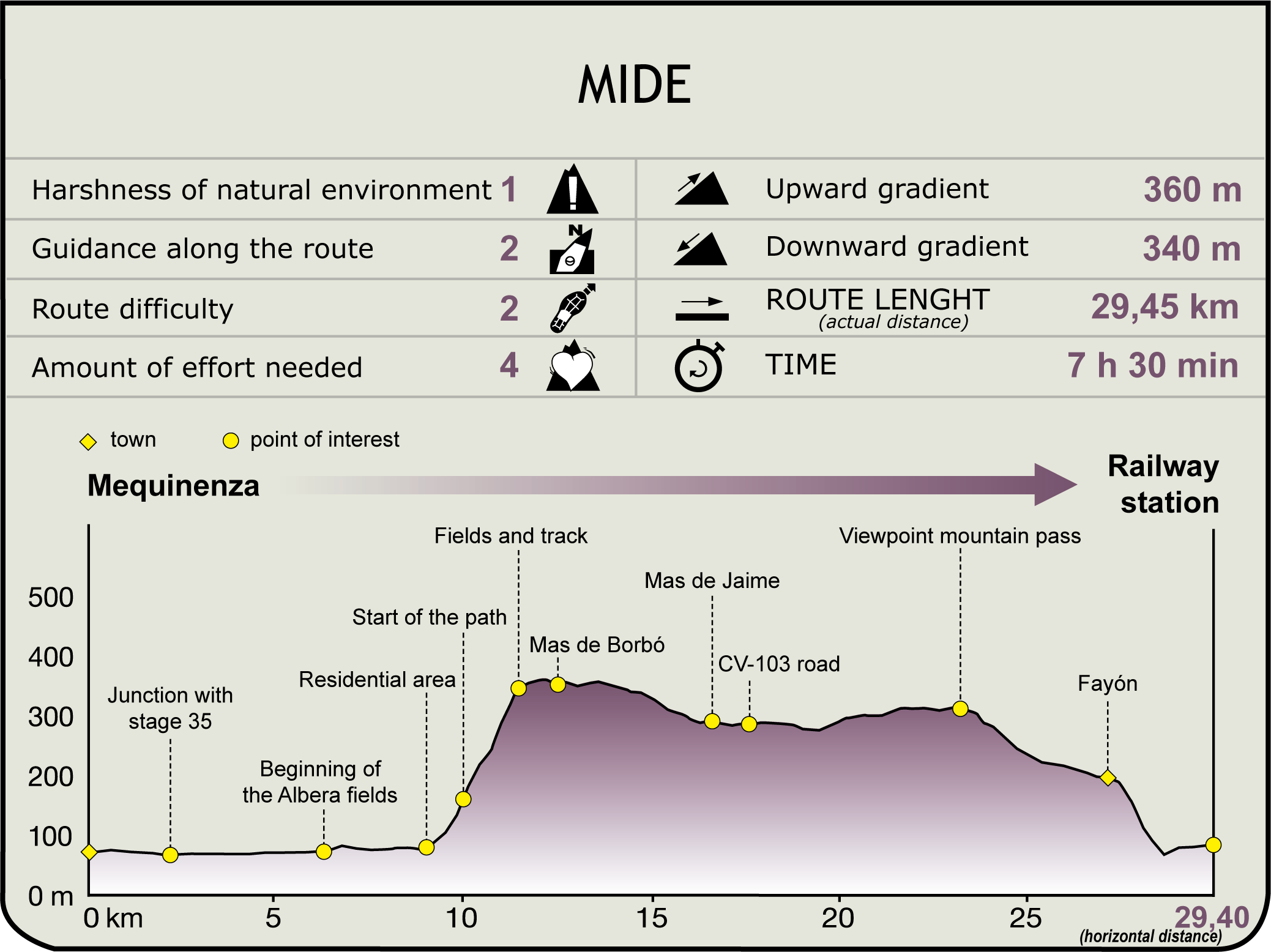
MIDE (Method for the Information of Excursions)
 Harshness of natural environment
- 1. The environment is not risk-free
- 2. There are more than one risk factors
- 3. There are various risk factors
- 4. There are quite a lot of risk factors
- 5. There are many risk factors
 Guidance along the route
- 1. Well defined trails and crossings
- 2. There is a clearly marked trail and signage
- 3. Requires the identification of geographic features and cardinal points
- 4. Requires off-path navigation
- 5. The trail is interrupted by obstacles that have to be gone around
 Route difficulty
- 1. Walking on a flat surface
- 2. Trails with different types of path
- 3. Walking on stepped paths or irregular terrain
- 4. The use of hands or jumping over the terrain is necessary
- 5. The use of hands is required to progress
 Amount of effort needed
- 1. Up to 1 hour of continuous walking
- 2. Between 1 and 3 hours of continuous walking
- 3. Between 3 and 6 hours of continuous walking
- 4. Between 6 and 10 hours of actual walking
- 5. More than 10 hours of continuous walking
Featured
Further information
Fayón
On 18 November 1967, construction was completed and the Riba-roja reservoir began to operate. This left the former village of Fayón under its waters. Due to this historic event, the more than 2,000 inhabitants had to seek a new place to settle. This gave rise to a new town at the confluence of the rivers Ebro and Matarraña, which today is also known as Fayón.
The River Matarraña and its basin
The Matarraña begins its journey at Puertos de Beceite, at an altitude of 1200 m, before descending through canyons and orchards and, after 97 km, flowing into the Ebro, under the Fayón bridge, 92 m above, to become part of the waters of the Riba-roja reservoir. The villages along this river are all very beautiful and represent the different cultures that have left their mark on them over the years; today, Beceite, Valderrobles, Ráfales and La Fresneda are Sites of Cultural Interest.
The Matarraña - Algars Nature Trail, which can be reached from Fayón, covers almost the entire basin of this river, allowing you to discover all this heritage, as well as its natural surroundings, which are also very attractive and interesting.
Multimedia

