Stage 31: Escatrón - Chiprana
Description
In search of the Chiprana salt lake, leaving the river to enter the steppe.
This section of the Ebro trail runs through two well-differentiated sectors, since the river bank becomes steppes that surround it to approach the valuable enclave of the Chiprana salt lake. Thus, the first kilometres accompany the Ebro, which is now dammed, harnessing the old Gotor irrigation ditch and agricultural tracks. It then crosses the Escatrón to Caspe road and, by the Piarroyos drove road, it reaches the Salada de Chiprana Nature Reserve. A natural area that is unique in the world due to its geological characteristics and the flora and fauna it hosts. Following the drove road, it returns to the river bank before finally entering Chiprana.
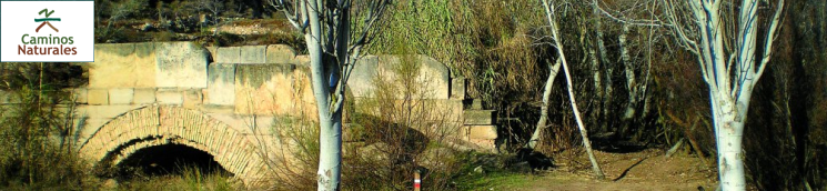
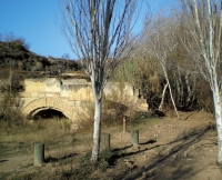
On the right bank of the Ebro, beside the Escatrón jetty and hostel, it continues through the river park, which will guide hikers along the edge of the Rueda weir. After 600 m, the view encounters the warehouses that the Real Compañía de Canalización del Ebro (Royal Company of Canalisation of the Ebro) built in 1958 for its navigation lines between Tortosa and Escatrón. A little further on, you leave the trail when it turns right to access the village, while, continuing straight on (east) along a leafy lane, you reach the mouth of the River Martín. It is necessary to continue up its fossil riverbed (the functional riverbed runs a few metres further on) as far as an Ibero-Roman bridge, built in brick and stone, with two spans and a cutwater.
A little more than 250 m will be required to reach the old Caspe road; as it passes under it, the trail again rises and crosses the River Martín. On the other side of the bridge, where there is a track, on the left (north), which descends parallel to the river. The Nature Trail takes it and, in barely 40 m, it deviates from it on the right before entering between two plots and taking an old path which ascends to the Ibero-Roman village of El Pueyo. From the pass where it is located, a track descends that connects with a larger one and, after about 700 m, reaches a crossing with an island in the middle. The hiker will continue straight on, cutting through the Gotor meander, as far as a water extraction hut, on the banks of the Ebro.
From this point onwards, along either a path or tracks, you round the Vuelta de Valero. Without ever losing sight of the Ebro, sometimes under sandstone escarpments, in the company of pines and crossing several gorges. Finally, you will reach livestock sheds, known in the areas as mases de Torjué, at the Vuelta de Moros. Shortly after that, you pass the Cerollera huts and the trail turns southeast, seeking a main track. After entering a watercourse leading away from the course of the Ebro, you turn left and take a detour that leads you directly to a promontory over the reservoir, with a water collection hut, a riverside shelter and a good viewpoint over the wide bend of the river, a very popular spot for fishermen. Starting from the intake pipe, the route continues along a step in the rock which, 100 m further on, becomes a path and moves into the Los Cados gorge. You will have cross its riverbed, near a beautifully-executed aqueduct, which is notable for the loss of its single central span. On the other side, the path returns to the riverside and, on a very steep hillside, it reaches the old Bacón orchard, which today is occupied by a tamarisk grove.

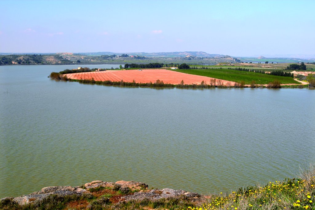
A progressive ascent then begins that carries hikers away from the riverbank, to which they will not return until the end of the stage. At a crossroads, where you go straight on, you can see the ruins of the Chipranescos reservoir. This is followed by several other crossroads at which you will change path (left, right, right and, finally, left), before finally leaving the old A-221 Caspe to Escatrón road. Following this infrastructure to the left, passing a pine stand, until you cross the current road and continue, on the opposite side, along a path that descends and leads to the Piarroyos drove road. This is where it meets the Ebro Way of St James. You will then cross a narrow area between sandstone crags (paleochannels), on the left, and pass a pond and a crossroads. The route continues straight on, but visitors can take the lane on the right, which is around 200 m long, to see the Chiprana salt lakes (saladas in Spanish). The Salada Grande is the deepest permanent salt lagoon in Europe at between 5.6 m and 3.6 m deep. A unique spot which has been declared a Directed Nature Reserve.
Continuing east from the crossroads, you will continue along a wide track until you reach the A-221 road, very near the bridge over the Regallo ravine. On the other side, the route takes an entrance on the left and continues along it, parallel to the road, to a rest area that welcomes the visitor with the Way of St James monument. With this structure still in your mind’s eye, you take a dirt track that approaches the river but which, before reaching its course, takes another, in this case ascending, which heads towards a promontory near the reservoir. Turn right, skirting a field of almond trees, before taking a path that ascends in an easterly direction before it ends by going up to the small road that connects Chiprana with its train station. The end is now near and, after a few more metres, you will reach the roundabout that marks the access to the village of Chiprana.
Sites of interest
Map
Puntos de Interés
Infraestructura
Profile
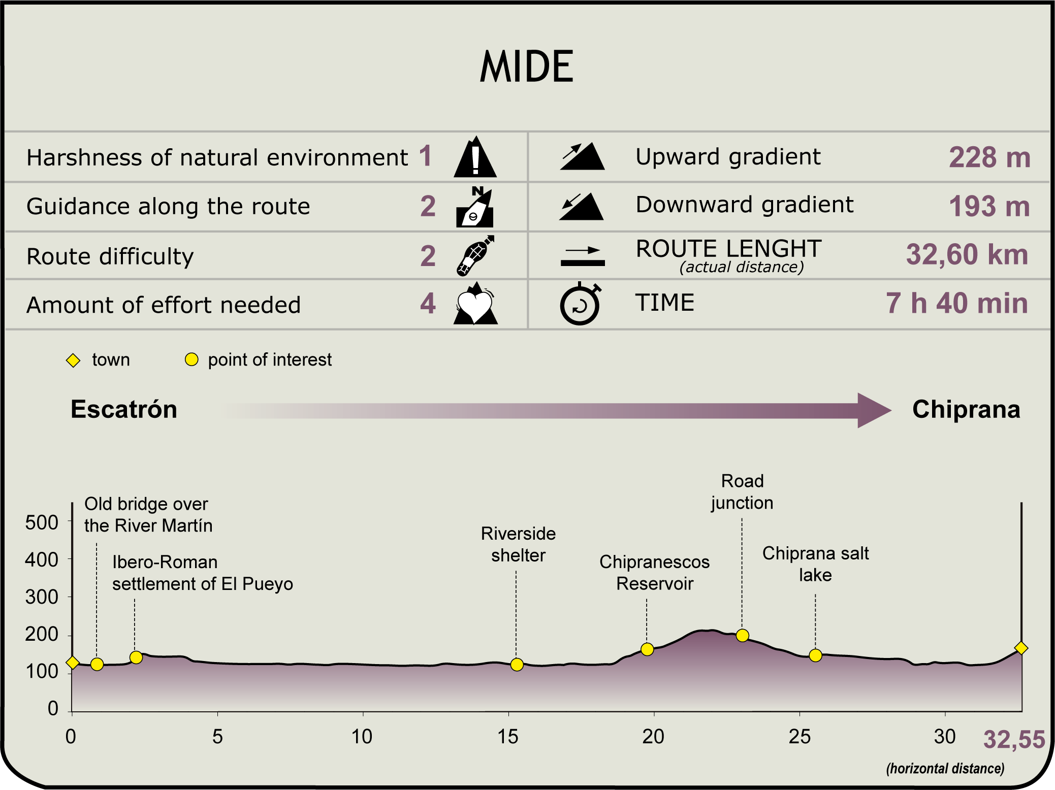
MIDE (Method for the Information of Excursions)
 Harshness of natural environment
- 1. The environment is not risk-free
- 2. There are more than one risk factors
- 3. There are various risk factors
- 4. There are quite a lot of risk factors
- 5. There are many risk factors
 Guidance along the route
- 1. Well defined trails and crossings
- 2. There is a clearly marked trail and signage
- 3. Requires the identification of geographic features and cardinal points
- 4. Requires off-path navigation
- 5. The trail is interrupted by obstacles that have to be gone around
 Route difficulty
- 1. Walking on a flat surface
- 2. Trails with different types of path
- 3. Walking on stepped paths or irregular terrain
- 4. The use of hands or jumping over the terrain is necessary
- 5. The use of hands is required to progress
 Amount of effort needed
- 1. Up to 1 hour of continuous walking
- 2. Between 1 and 3 hours of continuous walking
- 3. Between 3 and 6 hours of continuous walking
- 4. Between 6 and 10 hours of actual walking
- 5. More than 10 hours of continuous walking
Featured
Further information
Rueda Monastery
Despite being in the municipality of Sástago, the Escatrón viewpoint offers spectacular views of the monumental complex of Rueda monastery, which stands on the other side of the Ebro. This spectacular complex was named after the monumental waterwheel that supplied it with water, and is, along with the monasteries of Veruela and Piedra, one of the greatest jewels of Cistercian art in Aragon, preserving all the medieval buildings.
Its origins can be traced to 1182, when King Alfonso II of Aragon ceded the castle and borough of Escatrón to the monks. In 1202, monks began to arrive and founded the current monastery, building a small church dedicated to St Peter and, years later (1225), the monk and architect Brother Gil Rubio began construction of the temple under the patronage of Our Lady of Rueda, with the church being consecrated in 1238. From the second third of the 13th century on, the monastery received numerous donations and the protection of the Kings of Aragon, James I the Conqueror, Peter III, James II and Peter IV.
In the second half of the 16th century, Abbot Rubio began construction of the gallery in Plaza de San Pedro. In the 17th century, these works continued under the mandate of the abbot Juan Hugarte, comprising the gallery, guest quarters, the abbot’s palace, the porter’s lodge and the royal gate.
In the early 19th century, the monks abandoned the monastery in the face of the threat of the French troops during the War of Independence. They would return five years later at the end of the monastery, although, after the confiscation by Mendizábal, the community abandoned the monastery and its assets were sold.
After being abandoned, the complex began to deteriorate, despite having been declared a National Monument in 1924. This abandonment and deterioration ended when the Provincial Council of Aragon took over the title to all the lands and buildings, with the commitment to restoring the complex. Work began in 1991 and ended in 2003; a hotel was opened on the monastery’s grounds.
Multimedia