
Stage 8: Huertapelayo - Valtablado del Río
Description
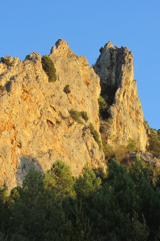
Life in the cliffs
The breath-taking rocky cliffs will amaze the visitors. These apparently barren and lifeless stone blocks are, indeed, an ideal environment for hundreds of animal and plant species that have adapted to the harsh conditions of the screes and limestone cliffs flanking the River Tagus.

This Stage begins at the Huertapelayo bus stop at the entrance of the town. Almost immediately, the route crosses over La Vega Brook and bears right, leaving the hamlet of Huertapelayo behind. The track ascends gradually, but steadily, offering extraordinary views of the valley.
Poplars (Populus spp.) on both riverbanks add a splash of green and yellow to the landscape in early autumn before the leaves begin to fall. The caves that dot the limestone cliffs and escarpments, with their delightful fancy shapes, are home to numerous species. If you completed the previous Stage, you will recognise the path common to both Stages, which ends at the interStage where a sign marks the beginning of Stage 8.
Young black pines (Pinus nigra), junipers(Juniperus communis) and gorse (Genista scorpius) alternate with Portuguese oaks (Quercus faginea) and holm oaks (Quercus ilex), found in the more exposed areas.
After nearly eight kilometres, the route reaches another crossroads where it veers 180º to the right onto a track that climbs slightly in parallel to the previous route until it reaches a new junction. The path to the left leads to a rest area with tables, a fountain and a stone shelter. However, this Stage continues to the right, descending gradually until the path becomes a narrow track.
The route descends through a rocky area where caution should be exercised. Boxwood bushes (Buxus sempervirens) and strawberry trees (Arbutus unedo) accompany the traveller in this stretch.
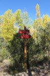
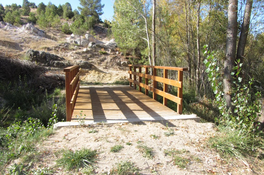
The path continues up-and-down until it reaches a rest area next to the ruins of a stone bridge known as “El Pontón”. A wide forest track can be seen next to the bridge, along which the route continues for 500 m, before bearing right, at a bend, down a path leading to the Hocino Ravine. The route crosses a wooden footbridge, shown in the image, and turns right onto a narrow path that ventures through a pine forest.
This area floods frequently at times of heavy rainfall, therefore the path may be covered with water.

The landscape along the path remains unchanged for more than five kilometres: a beautiful trail surrounded by rosemary (Rosmarinus officinalis) and strawberry trees, and shaded by pine trees. The Trail approaches and drifts away from the Tagus several times; however, as in other Stages of the Trail, it never completely loses sight of the river. At the end of the Stage, the path runs very close to the left bank of the river.
Near the end of the Stage, the route passes by the ruins of the Molino del Valle, and crosses the Repechos Ravine, to arrive at Valtablado del Río, flanked by crop farms dotted with huge walnut trees (Juglans regia). Valtablado lies on the westernmost edge of the Alto Tajo Nature Park, which is why the area is popularly known as the “Puerta del Alto Tajo” (Gateway to the Upper Tagus). This Stage of the Trail runs through the Alto Tajo Nature Park, Site of Community Importance (SCI) and Special Protection Area for Birds (SPA). From here, the Trail no longer ventures through these protected sites, although the river continues its course towards an equally interesting area: the Alcarria.
Profile
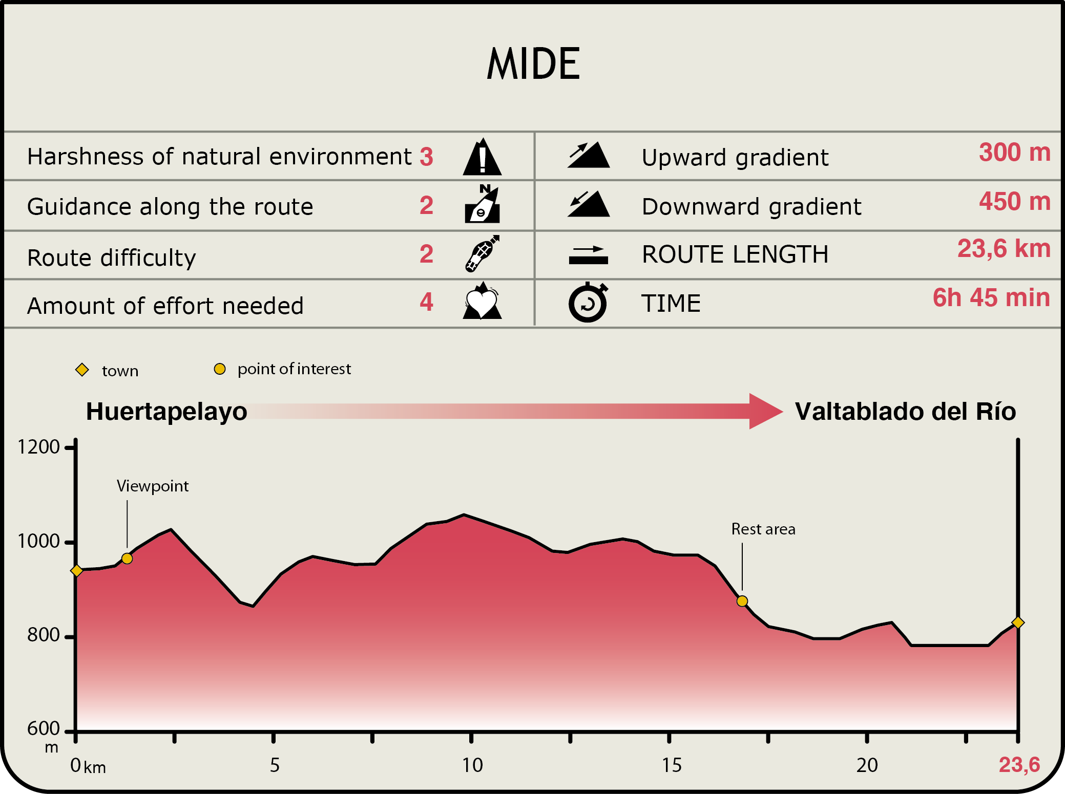
MIDE (Method for the Information of Excursions)
 Harshness of natural environment
- 1. The environment is not risk-free
- 2. There are more than one risk factors
- 3. There are various risk factors
- 4. There are quite a lot of risk factors
- 5. There are many risk factors
 Guidance along the route
- 1. Well defined trails and crossings
- 2. There is a clearly marked trail and signage
- 3. Requires the identification of geographic features and cardinal points
- 4. Requires off-path navigation
- 5. The trail is interrupted by obstacles that have to be gone around
 Route difficulty
- 1. Walking on a flat surface
- 2. Trails with different types of path
- 3. Walking on stepped paths or irregular terrain
- 4. The use of hands or jumping over the terrain is necessary
- 5. The use of hands is required to progress
 Amount of effort needed
- 1. Up to 1 hour of continuous walking
- 2. Between 1 and 3 hours of continuous walking
- 3. Between 3 and 6 hours of continuous walking
- 4. Between 6 and 10 hours of actual walking
- 5. More than 10 hours of continuous walking
Featured
Further information
Hundido de Armallones
One of the Alto Tajo Nature Park's georoutes ventures into the river canyon, leading the visitor towards one of the most interesting geological sites in the area, the “Hundido de Armallones”.
The route sets off towards the river canyon at Ocentejo, a small town in the Hoz Ravine, reaching a site where huge boulders that fell during the great Lisbon earthquake, in the sixteenth century, block the river.
Multimedia

Downloads
GPS Downloads
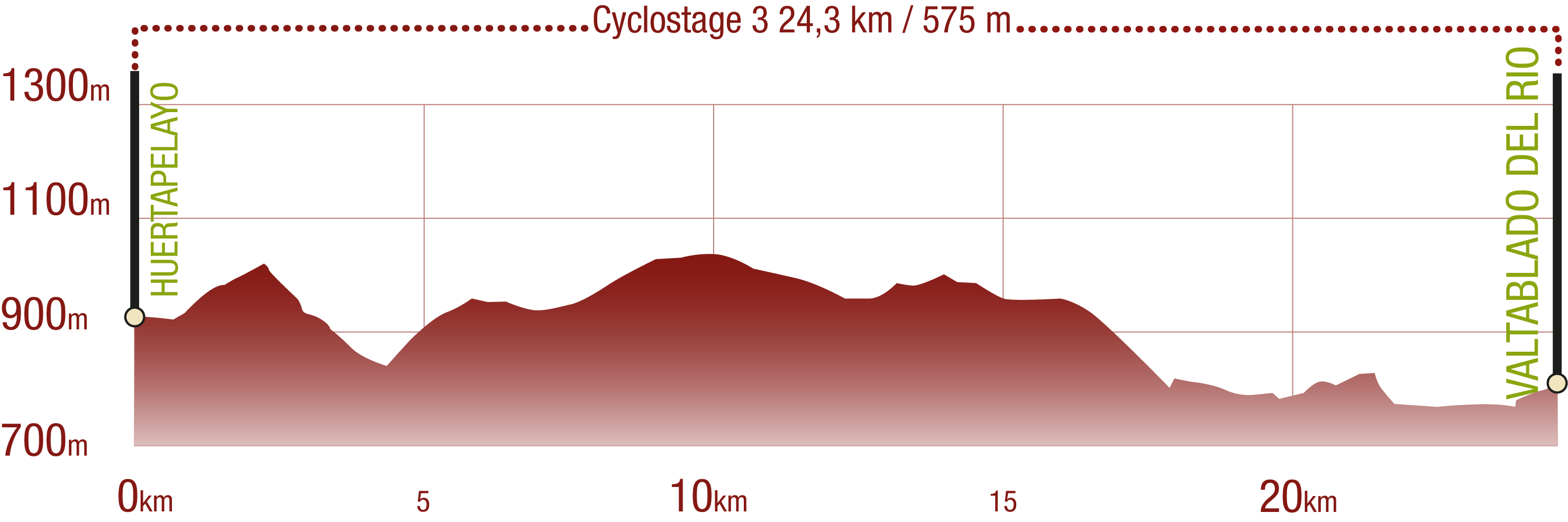
Cyclability
This Cyclostage corresponds to stage 8 of the Nature Trail
PROFILE
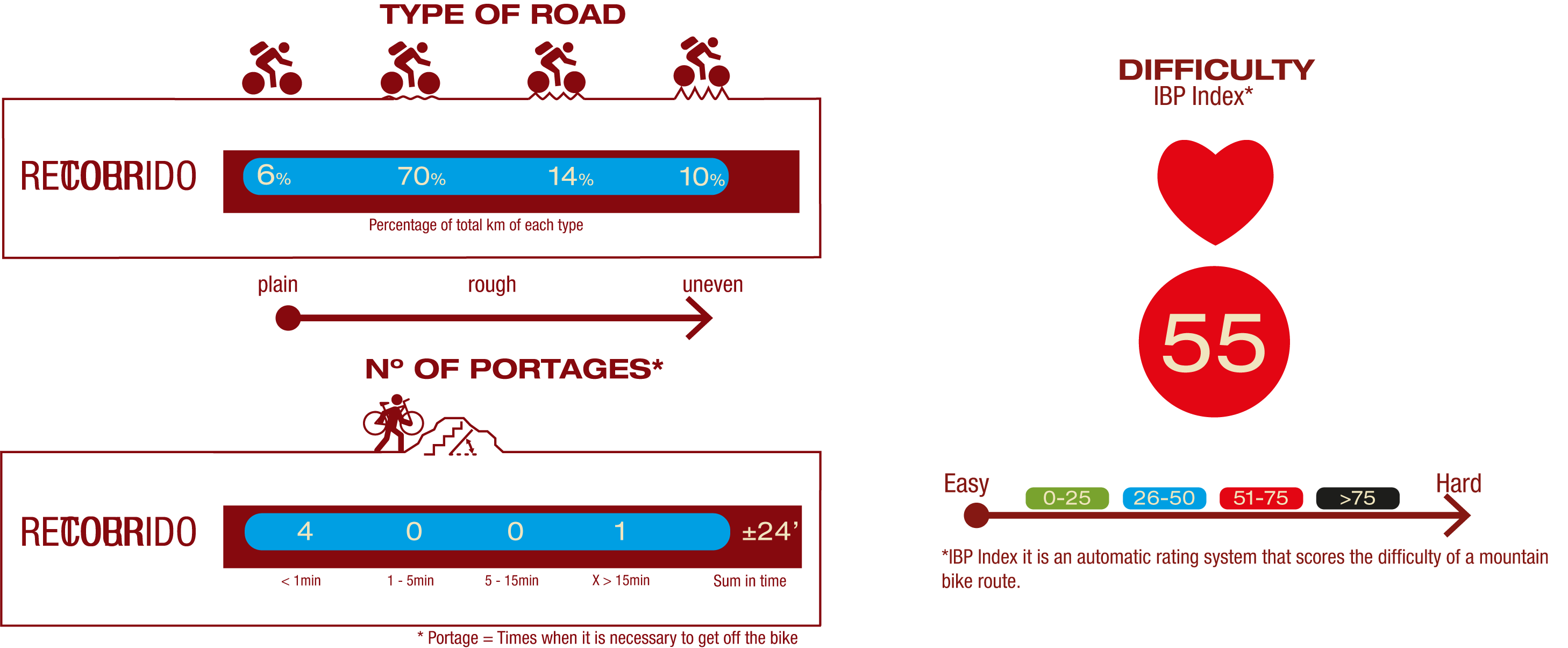
TYPE OF ROAD, PORTAGES & DIFFICULTY
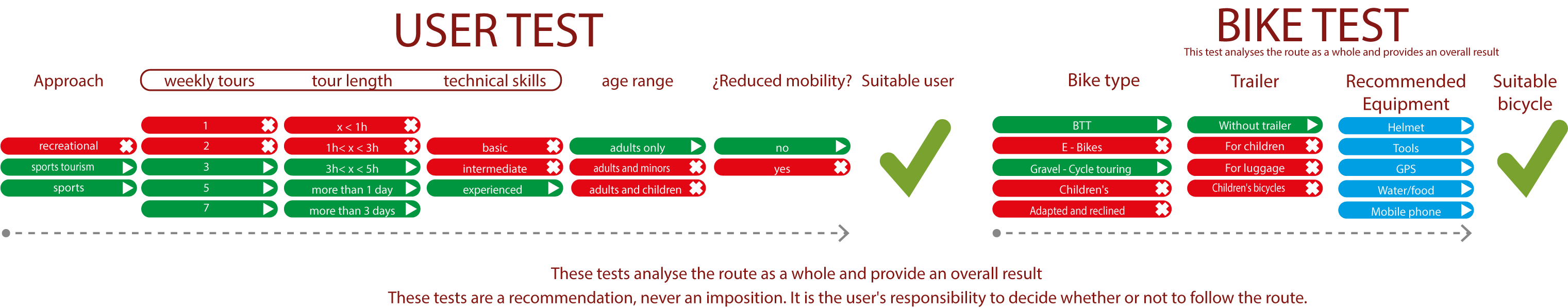
TEST
SAFETY RECOMMENDATIONS
- Sections shared with hikers.
- Transit through the centre of some population centres.
- In cyclostage 1 you will cross a straight tarmac road. Take extreme caution, look for a straight section and proceed to cross at the said straight section.
- In cyclostage 3 you will walk along a stretch close to the riverbed. This area is prone to flooding during the flood season.
GENERAL RECOMMENDATIONS
- Find out about the technical aspects of the route and the weather on the day.
- Take care of the environment. Take care not to disturb animals or damage vegetation. Respect private areas.
- You must give priority to pedestrians and comply with general traffic rules.
- The environment in which you will be riding is open, free to move around and an area where many activities are carried out (sporting, forestry, livestock and agricultural activities). Always have an understanding, prudent, responsible and respectful attitude.