
Stage 5: Poveda de la Sierra - Zaorejas
Description
Between walls
This Stage runs wedged between massive limestone cliffs. The feeling of walking along the bottom of a canyon, carved over millions of years by the river, with amazing scenery is indescribable.
The Stage begins at Poveda de la Sierra, and overlaps the end of the previous Stage during five kilometres. The Trail heads northwest out of the town, turning first to the right, and then to the left, onto a well-maintained wide track leading to the River Tagus.
As the traveller proceeds down the path, pine forests replace Portuguese oak (Quercus faginea), where livestock coexist with cervids.
The stretch shared by Stages 4 and 5 ends at the crossing, where the path turns left towards a bridge over the Merdero Brook, with the River Tagus to the right, where it will remain throughout this Stage. Huge forests of black poplars (Populus nigra) and rosemary willows (Salix eleagnos), flank the river, which provides a steady supply of water. The black pines (Pinus nigra) that line the Trail slowly give way to Portuguese oaks, which will soon cover the steep slopes of the valley.
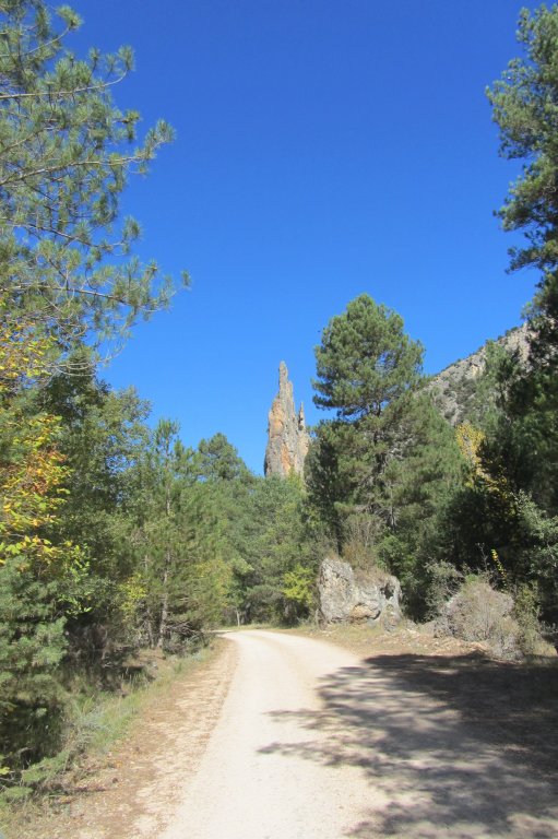
The route runs next to the "El Vivero" recreational area, and continues straight ahead at the fork. Further on, a fountain with untreated water allows the traveller to cool off before moving on. Spectacular views of the rocky cliffs overlooking the clear waters of the upper reaches of the River Tagus can be seen from this vantage point.
The route continues along the same track for several kilometres. The landscape around the path changes with every season. Canadian aspen (Populus tremula), hazel(Corylus avellana), dogwood (Cornus sanguinea) and dog rose (Rosa canina) change colour throughout the year, offering the traveller a different experience each season.
The path proceeds in the shade of an adult pine forest, where Coal Tits (Parus ater), Blue Tits (Parus caeruleus) and Red Crossbills (Loxia curvirostra) have found an excellent place for living and nesting.
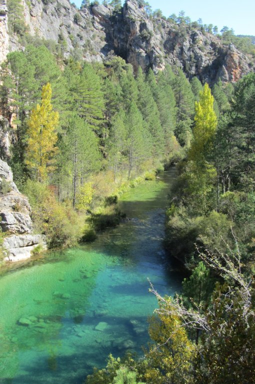
The route reaches Fuente la Parra Hostel, and continues to the left towards Zaorejas, accompanied at all times by the River Tagus, wedged-in and hidden under the dense forest on the left bank. Unlike the upper reaches, fish abound in this part of the river, attracting a large number of fish-hunting animals such as otters (Lutra lutra), Herons(Ardea cinerea), Kingfishers(Alcedo atthis), Little Grebes (Tachybaptus ruficollis) or viperine water snakes (Natrix maura). The vegetation, lush and diverse, is populated by herbivores such as Southwestern water voles (Arvicola sapidus) and provides shelter to Eurasian Reed Warblers (Acrocephalus scirpaceus) and Little Ringed Plovers (Charadrius dubius). Eurasian Golden Orioles (Oriolus oriolus) and Common Chiffchaffs (Phylloscopus collybita), feed primarily on insects, and they, in turn, are hunted by Eurasian Sparrowhawks (Accipiter nisus) and Common Kestrels (Falco tinnunculus). The water is populated by different fish species, including Iberian Nase (Pseudochondrostoma polylepis), Common Iberian Barbel(Barbus bocagei) or "bermejuela" (Achondrostoma arcasii) and American Crayfish(Procambarus clarkii) that feed on small invertebrates and submerged aquatic vegetation. Such rich biodiversity is not fortuitous, since this Stage runs almost entirely through the Alto Tajo Nature Park and the "Alto Tajo" Site of Community Importance (SCI) and Special Protection Area for Birds (SPA). The contact information of the Nature Park's visitor centre appears at the end of this guide.
Leaving behind the Salmerón Ford, with a rest area and shelter nearby, the path climbs slightly to a large meander where, with a little luck, one can see the slow flutter of barbel and trout (Salmo trutta).

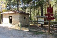
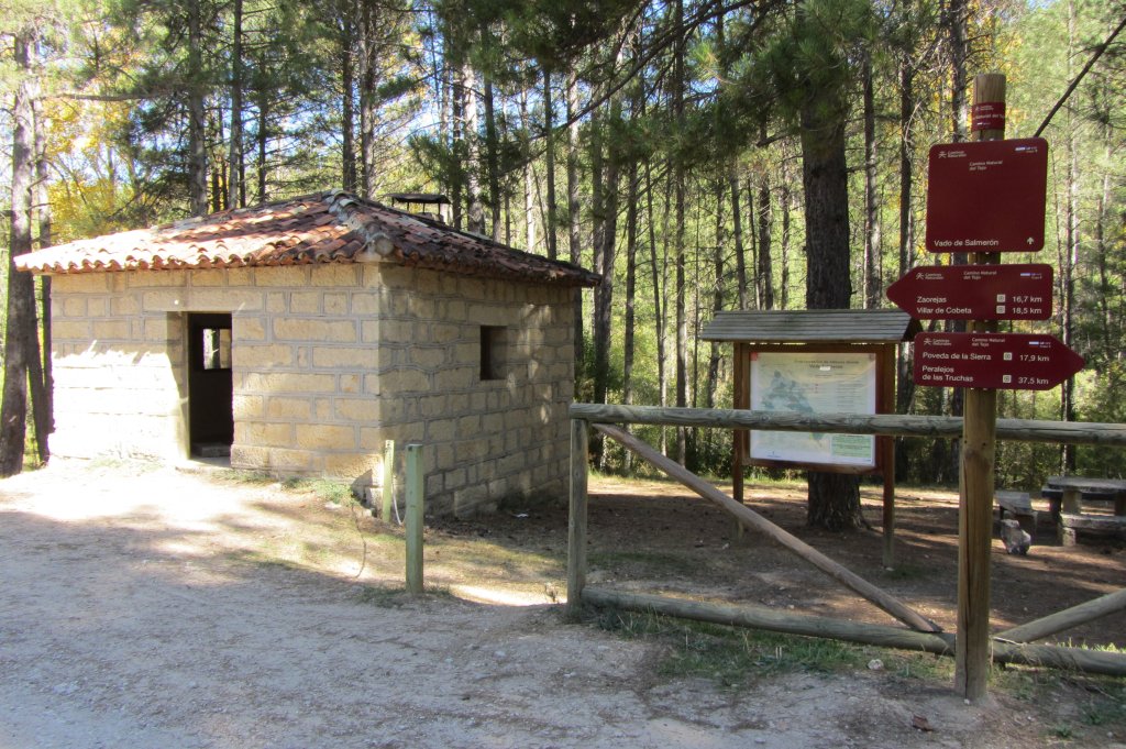
The forest track arrives at Fuente de la Falaguera recreation area, equipped with several services, where the traveller may rest before proceeding. The route continues another two kilometres before it climbs up a flight of wooden steps to the left. From here, one can enjoy spectacular views of Ciño Negro Ravine and, at certain times of the year, of its namesake waterfall. The stretch of the Trail shared by Stages 5 and 6 (respectively, entrance to and exit from Zaorejas) starts in the immediate vicinity of this tuff waterfall.
The route continues its ascent to a large rock that serves as a natural viewpoint over the river, from where it is possible to watch the relaxed flight of Griffon Vultures (Gyps fulvus) on the warm air currents. In this part of the Stage, the Nature Trail runs along the same path as a geological route, therefore interpretative panels are a common sight. Nearby are the Escaleruela tuff waterfall and the Mirador de San Pedro.
The route continues along a path sandwiched between limestone and tuff walls. It runs along the seasonal Ciño Negro Brook, with huge walnut trees (Juglans regia) and small market gardens on the banks. After crossing a wooden footbridge, the route continues another 1.8 kilometres along a wider meandering path, then turns left past a cluster of beehives. From here, the road gradually fades away.
The Trail proceeds up and down along a narrow, stony path surrounded by Spanish junipers (Juniperus thurifera), crosses a ravine, leaves behind a farm and arrives at Zaorejas, the endpoint of this Stage.
Sites of interest
Profile
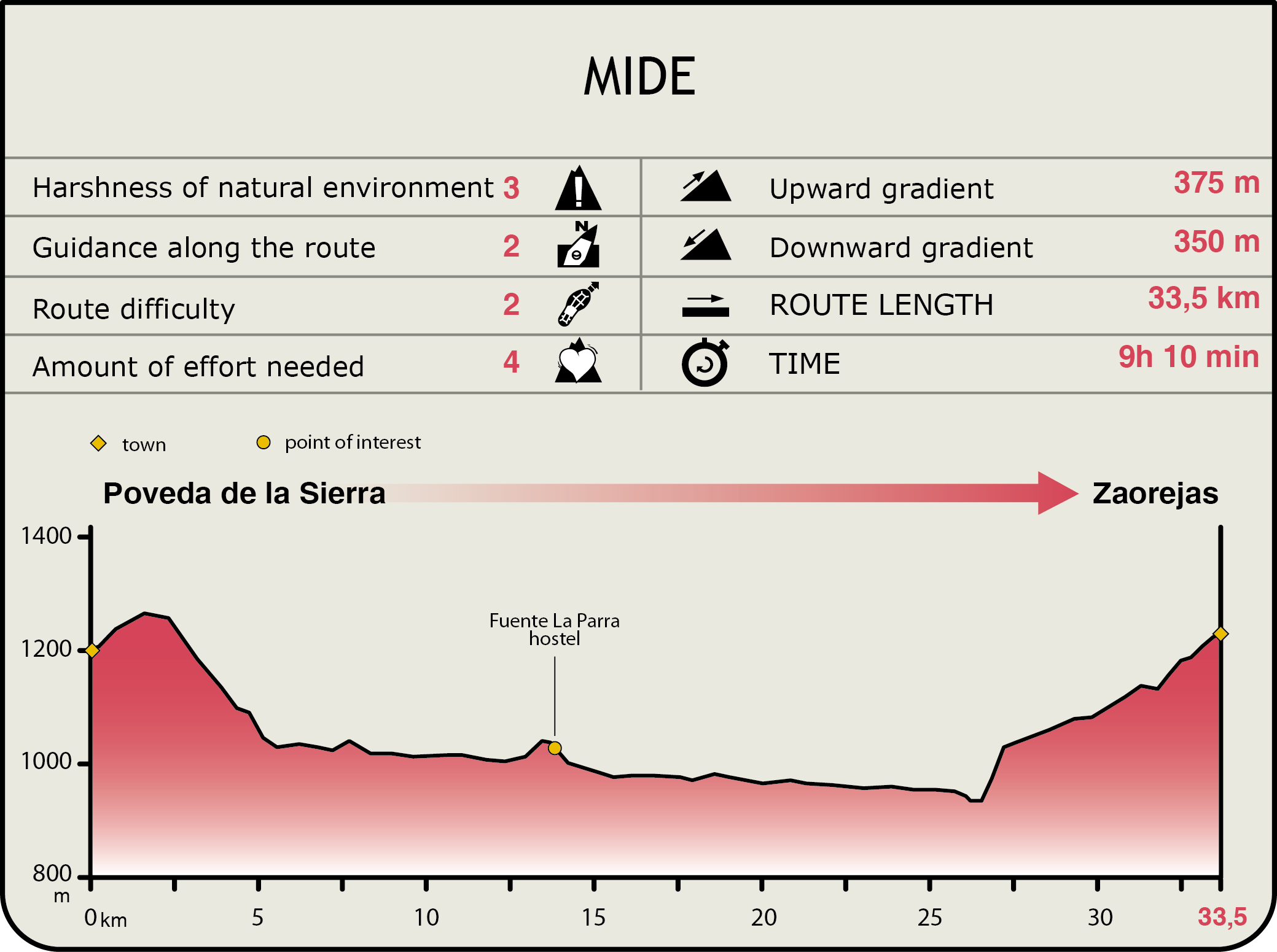
MIDE (Method for the Information of Excursions)
 Harshness of natural environment
- 1. The environment is not risk-free
- 2. There are more than one risk factors
- 3. There are various risk factors
- 4. There are quite a lot of risk factors
- 5. There are many risk factors
 Guidance along the route
- 1. Well defined trails and crossings
- 2. There is a clearly marked trail and signage
- 3. Requires the identification of geographic features and cardinal points
- 4. Requires off-path navigation
- 5. The trail is interrupted by obstacles that have to be gone around
 Route difficulty
- 1. Walking on a flat surface
- 2. Trails with different types of path
- 3. Walking on stepped paths or irregular terrain
- 4. The use of hands or jumping over the terrain is necessary
- 5. The use of hands is required to progress
 Amount of effort needed
- 1. Up to 1 hour of continuous walking
- 2. Between 1 and 3 hours of continuous walking
- 3. Between 3 and 6 hours of continuous walking
- 4. Between 6 and 10 hours of actual walking
- 5. More than 10 hours of continuous walking
Featured
Further information
Fiesta de los Gancheros
The Fiesta de los Gancheros has been taking place in the Alto Tajo (Guadalajara) for ten years.
It is a tribute to the "gancheros"; a craft long lost that consisted in floating the timber down the river. The "gancheros" had to be strong to drag the timbers to the river and, once there, tie and guide them to the riverbank, often against the current.
This feast seeks to keep alive the memory of these men, and pay tribute to traditional rural activities that have shaped the life and culture of our towns whilst fostering coexistence.
Multimedia
Downloads
GPS Downloads
Maps
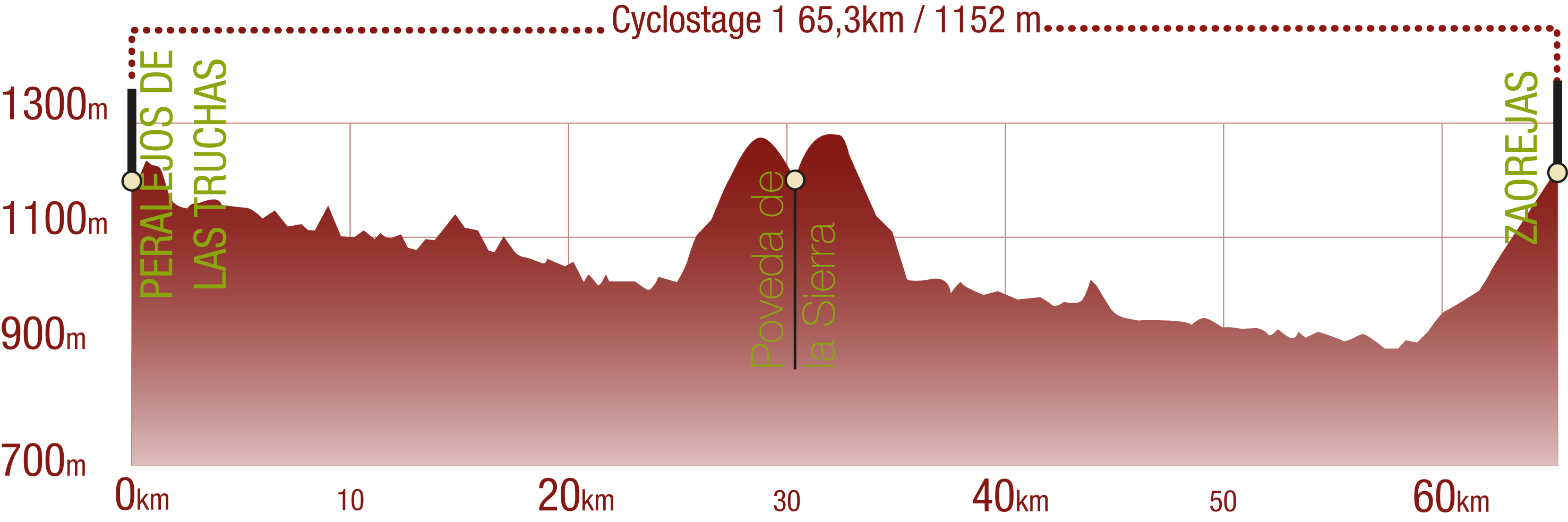
Cyclability
This Cyclostage corresponds to stages 4 & 5 of the Nature Trail
PROFILE
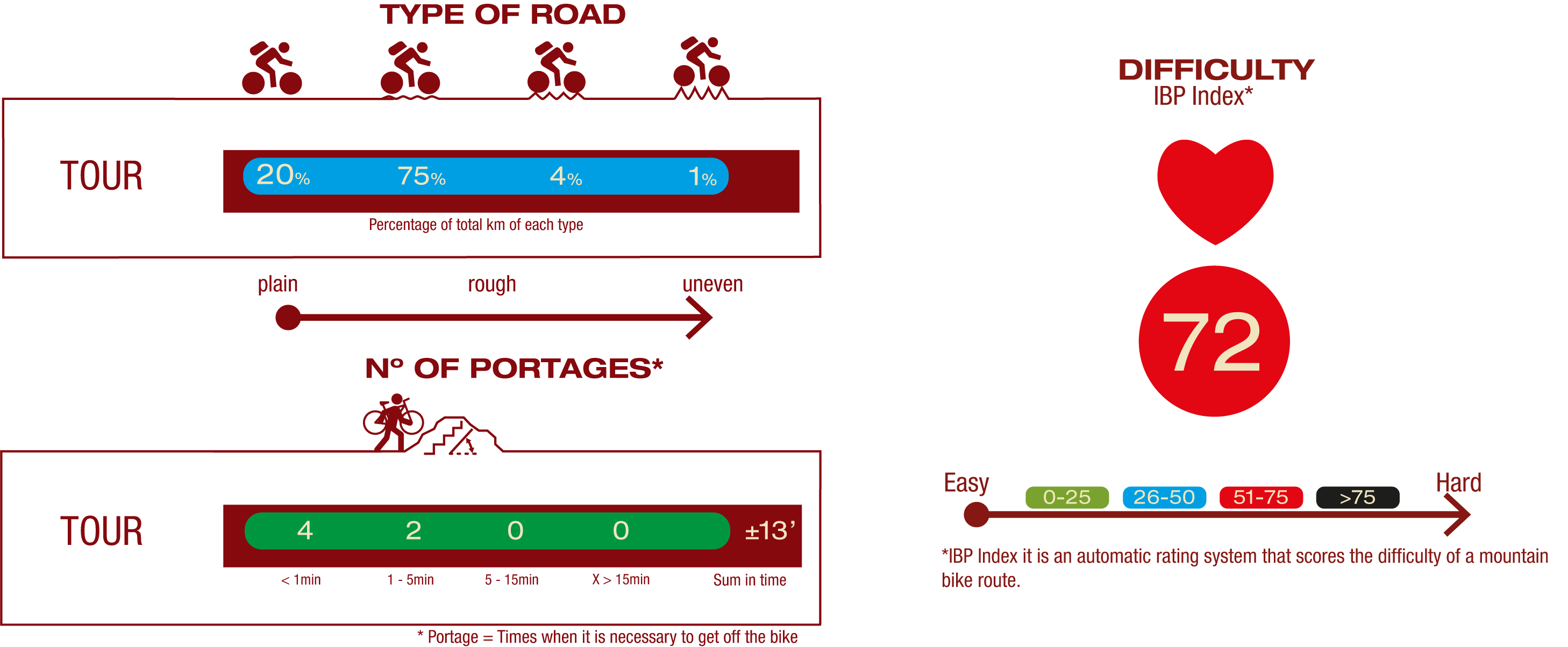
TYPE OF ROAD, PORTAGES & DIFFICULTY
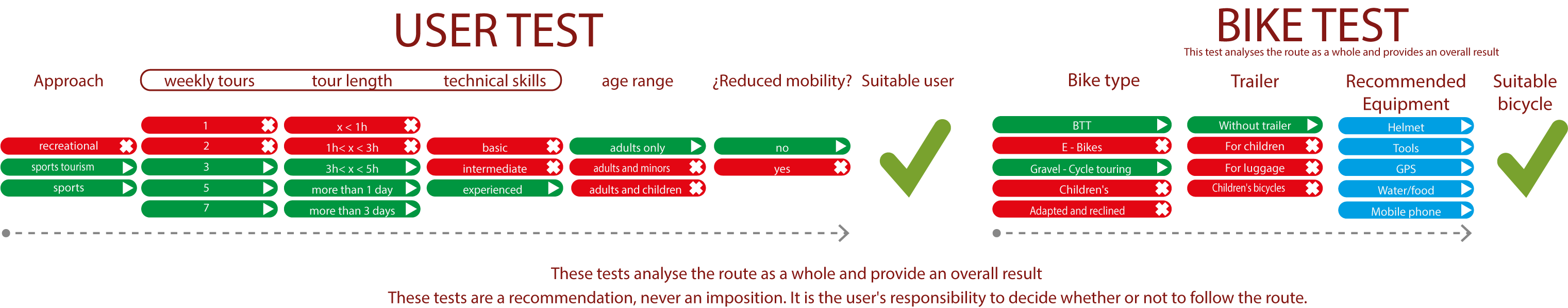
TEST
SAFETY RECOMMENDATIONS
- Sections shared with hikers.
- Transit through the centre of some population centres.
- In cyclostage 1 you will cross a straight tarmac road. Take extreme caution, look for a straight section and proceed to cross at the said straight section.
- In cyclostage 3 you will walk along a stretch close to the riverbed. This area is prone to flooding during the flood season.
GENERAL RECOMMENDATIONS
- Find out about the technical aspects of the route and the weather on the day.
- Take care of the environment. Take care not to disturb animals or damage vegetation. Respect private areas.
- You must give priority to pedestrians and comply with general traffic rules.
- The environment in which you will be riding is open, free to move around and an area where many activities are carried out (sporting, forestry, livestock and agricultural activities). Always have an understanding, prudent, responsible and respectful attitude.