Stage 27: Calera y Chozas - Aldeanueva de Barbarroya
Description
Sharing the route with the Jara Green Track
- - - - - - - -
IMPORTANT WARNING!: Due to reasons beyond the control of the Nature Trails Programme, and because of the conservation conditions of the Jara Greenway Nature Trail and the serious safety issues resulting of that condition, the TAJO NATURE TRAIL IS TEMPORARY CLOSED in the section that overlapes with Jara Greenway Nature Trail (from Silos halt, at Calera y Chozas, to Aldeanueva de Barbarroya). The changes in the itinerary shall be notified and as long as this situation persists, the use of this trail section is not allowed. If there is any accident or incident, it will be the sole responsability of whoever fails to comply this warning.
- - - - - - - -
In this stage, the Tagus Nature Trail shares the route with the Jara Green Track, venturing through the spectacular landscapes of Azután Reservoir, along a former rail track with multiple tunnels and a breathtakingly high bridge over the reservoir.
The route sets off at the southern edge of Calera y Chozas, next to a playground with an information panel on this Stage. Further on, it crosses a bridge over the Jara Green Nature Track, with which it will merge a few kilometres later.
The wide track, without many bends, leads to the river. Stages 26 and 27 share this part of the route.
From the outset, grain and cornfields, as well as irrigation ditches, flank the Trail. At the interStage of the two Stages, the route continues straight ahead, leaving to the left, a path leading upstream to Talavera. The Trail continues straight ahead towards the river, although it does not quite reach it, as a paved road in good conditions with the lanes properly marked, interrupts the route before it reaches the riverbank. The path turns right at the interStage with this road, and continues 3.5 km along its shoulder. The road veers gradually to the northwest, away from the river, and further on, crosses Alameda Creek, with an abundant flow, just a few metres before it meets the Tagus.
The Trail turns left at an interStage onto a farm track flanked by canals and irrigated fields. After several well-marked twists and turns, and past a bridge over Valserrano Canal, the route begins a slow ascent from the fertile river plains towards the interStage with the CM-4160. From here, it turns left to continue for 1.5 km along the shoulder of this paved road. The path then takes the right branch at the fork, arriving soon after at the Jara Green Track that it had already intersected outside Calera y Chozas. The access to the Trail could not be more spectacular. It is almost as if one were trying to catch the train at Silos stop, where information points and a well-equipped rest area can be found.
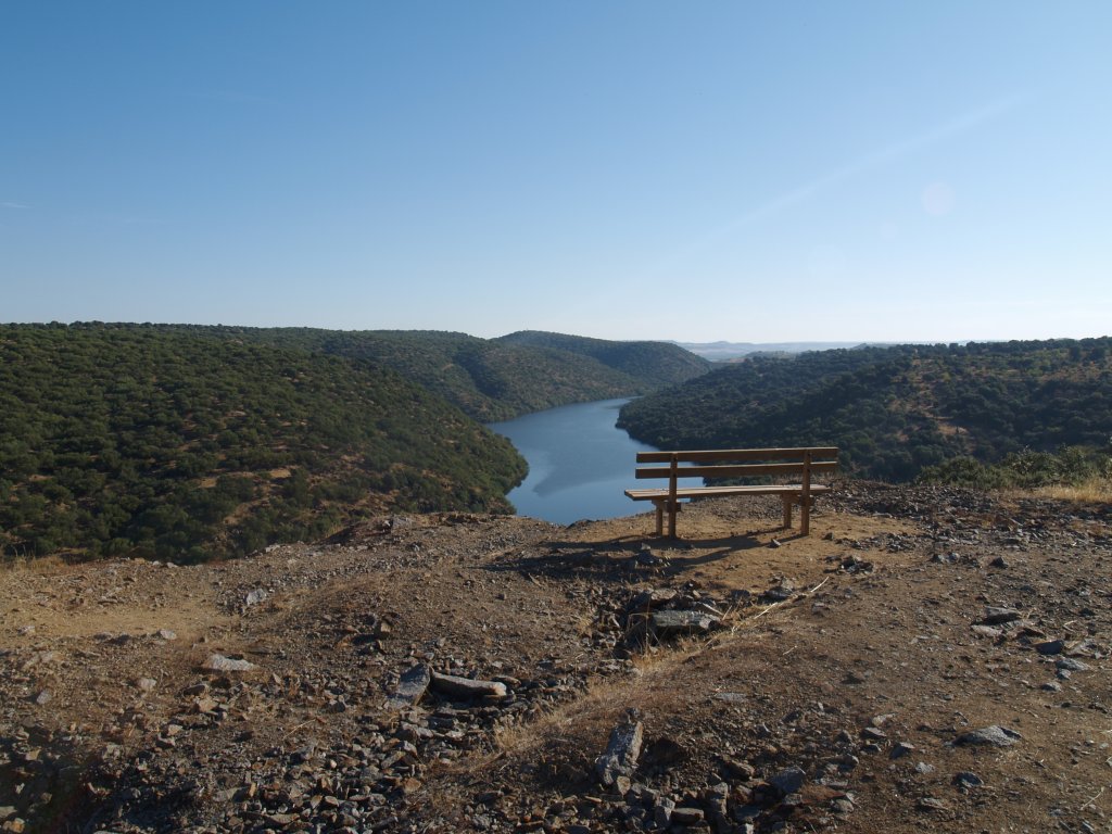
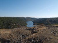
From here, the route dives into the history of one of the more emblematic railroads in the area. One can feel from the first few metres that this place is special: many stone bridges with perfect arches, the Trail wedged between high embankments, and the unexpected sight of the quick-flowing river to the left. This area is dominated by the Azután Reservoir. There are rest areas, fountains (drinking quality is unknown) and numerous viewpoints scattered along the way. Holm oaks (Quercus ilex) and granite boulders give the area a somewhat hostile and inaccessible appearance.
One can catch continuous glimpses of the reservoir and the tunnels. It should be noted that the tunnels lack lighting; therefore, caution should be exercised as many bikers use this Trail.
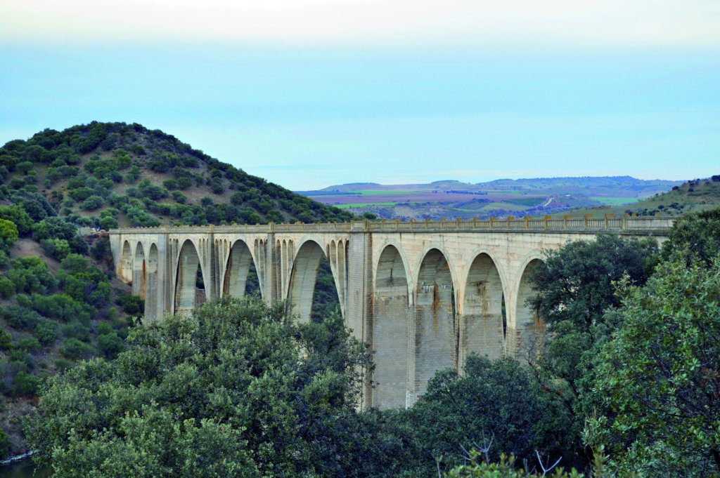
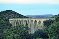
One of the more spectacular parts of this Stage, and even of the whole area, can be seen when one exits the third tunnel from Silos: the railway bridge over Azután Reservoir. Huge in size and several hundred metres long, it provides a wonderful viewpoint over the reservoir and the steep slopes that confine the river.
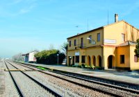
Back on "land", many rest areas provide a welcome break. The end of the Stage is less than 2 km away. Indeed, the first houses in Aldeanueva de Barbarroya are already within sight. The final stretch of the route traverses through an agrarian landscape of fields of grain and olive trees. The access to the town, and the end of the Stage, is at railway stop, where benches and a fountain can be found. It is almost as if the traveller had taken a train ride. An interStage to the left of the "tracks" is the endpoint of this Stage.
The final part of the Stage traversed through the “Ríos de la Margen Izquierda del Tajo y Berrocales del Tajo” Site of Community Interest (SCI) and Special Protection Area for Birds (SPA).
Sites of interest
Profile
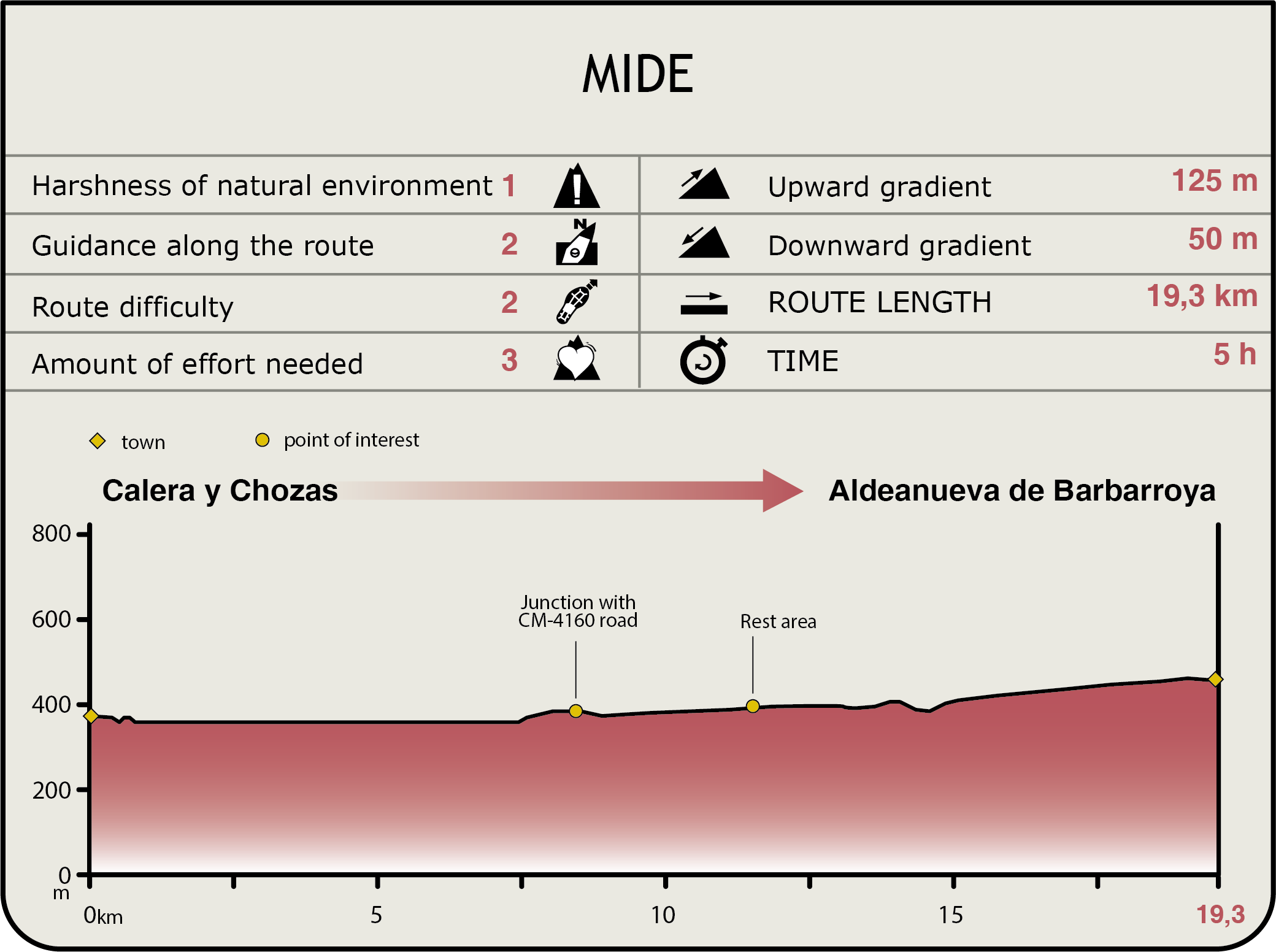
MIDE (Method for the Information of Excursions)
 Harshness of natural environment
- 1. The environment is not risk-free
- 2. There are more than one risk factors
- 3. There are various risk factors
- 4. There are quite a lot of risk factors
- 5. There are many risk factors
 Guidance along the route
- 1. Well defined trails and crossings
- 2. There is a clearly marked trail and signage
- 3. Requires the identification of geographic features and cardinal points
- 4. Requires off-path navigation
- 5. The trail is interrupted by obstacles that have to be gone around
 Route difficulty
- 1. Walking on a flat surface
- 2. Trails with different types of path
- 3. Walking on stepped paths or irregular terrain
- 4. The use of hands or jumping over the terrain is necessary
- 5. The use of hands is required to progress
 Amount of effort needed
- 1. Up to 1 hour of continuous walking
- 2. Between 1 and 3 hours of continuous walking
- 3. Between 3 and 6 hours of continuous walking
- 4. Between 6 and 10 hours of actual walking
- 5. More than 10 hours of continuous walking
Featured
Further information
Ríos de la Margen Izquierda del Tajo y Berrocales del Tajo SCI and SPA
These tributaries, whose headwaters lie in Montes de Toledo, flow through the Jara district, along the left bank of the Tagus River. Deep furrows and small granite canyons provide an ideal habitat for cliff-nesting bird species, including Bonelli's Eagle (Hieraaetus fasciatus) and Black Stork(Ciconia nigra).
The trees and shrubs in the area are riparian in nature, with ash forests dominating the upper reaches, whilst willows and Ibero-African shrubby spurge inhabit the middle and lower Stages.
Notable is the large African boxthorn shrubs at Aldeanueva de Barbarroya, a chasmophytic vegetation of great value. These plants have extensive, deep taproots that enter cracks in the substrate.
Multimedia