Stage 13: Sacedón - Sayatón
Description
Near Entrepeñas Reservoir
This Stage of the Trail runs along the right bank of the River Tagus, from Entrepeñas Reservoir to Bolarque Waterfall, near Sayatón. The landscape alternates between valleys and ravines surrounding the River Tagus, and flatlands where crops, pine forests and olive groves coexist.
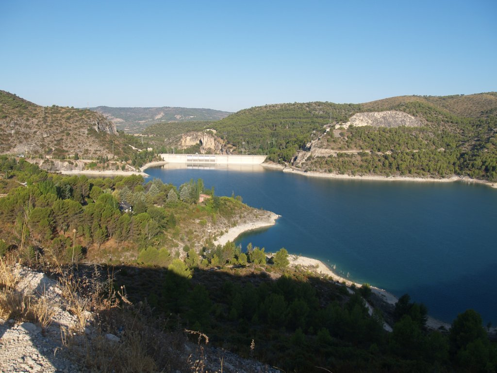
Stage 13 starts in the town of Sacedón. Several viewpoints can be found just few metres after the start, with excellent views of the Entrepeñas Reservoir. Information on the water sports practiced at the reservoir is available at the village of SacedónStage 13 starts in the town of Sacedón. Several viewpoints can be found just few metres after the start, with excellent views of the Entrepeñas Reservoir. Information on the water sports practiced at the reservoir is available at the village of Sacedón.
The route leaves the town via the road to Cuenca leading to the reservoir. Travellers who have already completed Stage 12 will find this part of the route familiar as it is a shared Stage. You will also be aware that the Stage is interrupted for about 450 m, when it merges onto the paved road leading to the N-320 and continues along the N-320 itself.
Once this stretch along the N-320 is completed, (it is advisable to use a vehicle in this Stage for safety reason), the Trail continues to the right, just after the tunnel. This route skirts around the massif, to the left, and the reservoir, to the right. A rest area with benches and tables can be found near the reservoir.
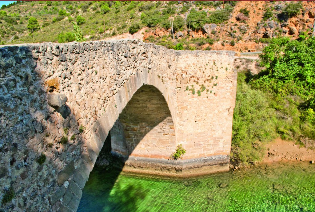
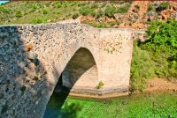
Leaving behind the reservoir, the Stage continues along the foothills of Entrepeñas Valley, on the left bank of the river, at about 20-25 m above the riverbed; therefore, extreme caution should be exercised to avoid any falls. Once in the valley, the path reaches a medieval stone bridge from where you can contemplate the beauty of the river and its banks. Although there is some risk of landslides, the areas are properly marked.
The route passes through the Sierra de Altomira Site of Community Importance (SCI) and Special Protection Area for Birds (SPA).
From here, the Stage runs almost entirely along the right bank of the river. The route reaches the interStage with CM-2009, and crosses the Auñón Stream. The stretch shared with Stage 12 ends at this point, when the route turns left.
This part of the Trail alternates between local roads, forest tracks and paths, where loose stones will slow down the pace and prevent the use of bicycles. The largest height differences have been levelled out with properly marked stairs.
The CM-2009 plays a key role in this Stage, as the Trail runs along this road for about 7.5 km.
This first part of the Stage features narrow valleys and many ravines along the lower reaches of the river Tagus. The middle and final part of the Stage consists of low-lying areas with few slopes, covered with large groves of olive trees, walnut (Juglans regia), pines (Pinus ssp.).
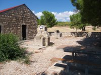
Before reaching the village of Sayatón, and after leaving the CM-2009 to venture through large cereal fields, there is a small rest area with tables and benches, as well as barbecue grills.
The Castle of Anguix can be seen from the road between Sacedón and Sayatón, sitting atop a rock on a high hill, near the River Tagus. The Stage ends in Sayatón, which boasts the shrine to its patron saint, San Roque, and a sixteenth century church.
Sites of interest
Profile
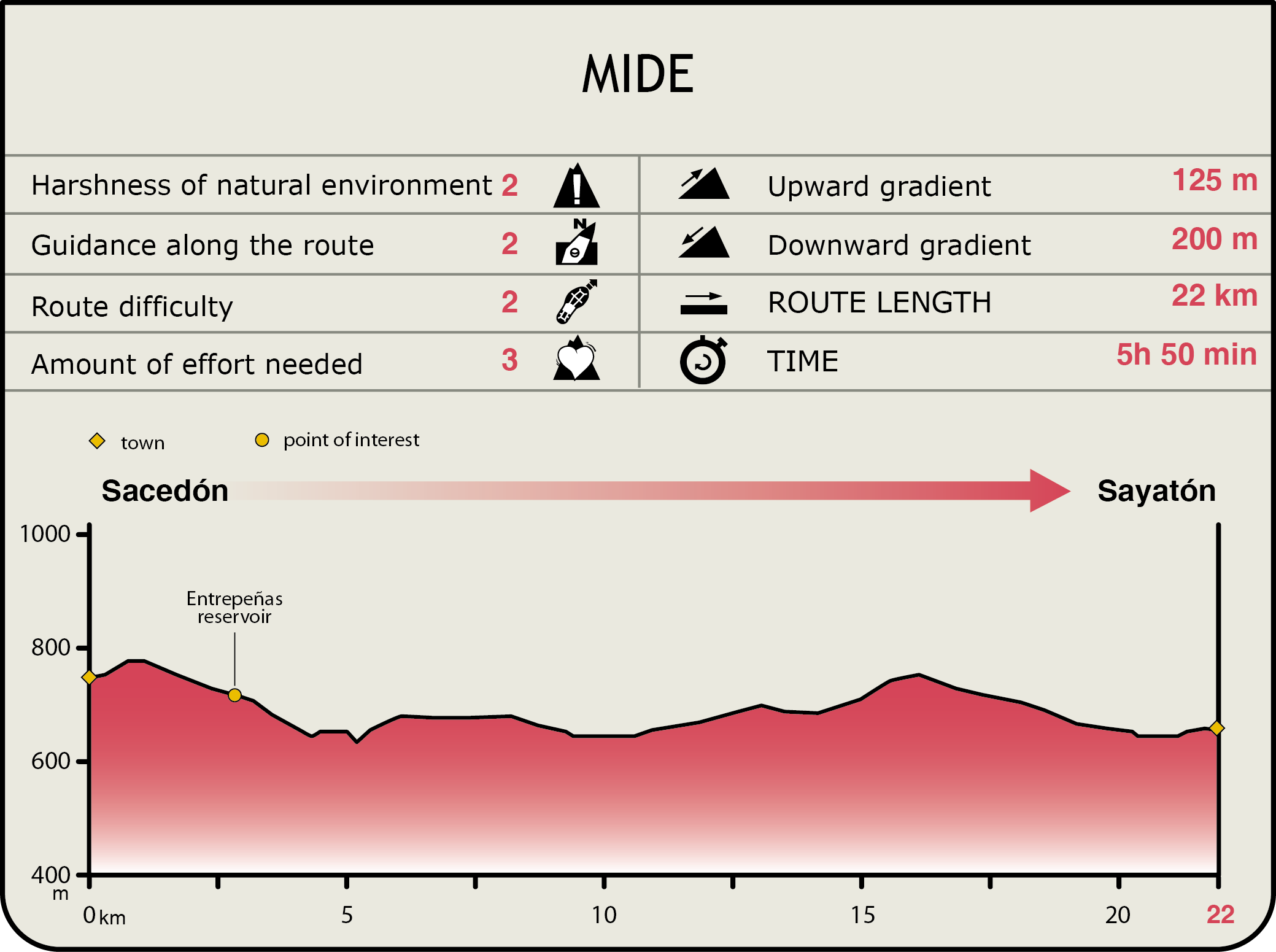
MIDE (Method for the Information of Excursions)
 Harshness of natural environment
- 1. The environment is not risk-free
- 2. There are more than one risk factors
- 3. There are various risk factors
- 4. There are quite a lot of risk factors
- 5. There are many risk factors
 Guidance along the route
- 1. Well defined trails and crossings
- 2. There is a clearly marked trail and signage
- 3. Requires the identification of geographic features and cardinal points
- 4. Requires off-path navigation
- 5. The trail is interrupted by obstacles that have to be gone around
 Route difficulty
- 1. Walking on a flat surface
- 2. Trails with different types of path
- 3. Walking on stepped paths or irregular terrain
- 4. The use of hands or jumping over the terrain is necessary
- 5. The use of hands is required to progress
 Amount of effort needed
- 1. Up to 1 hour of continuous walking
- 2. Between 1 and 3 hours of continuous walking
- 3. Between 3 and 6 hours of continuous walking
- 4. Between 6 and 10 hours of actual walking
- 5. More than 10 hours of continuous walking
Featured
Further information
Entrepeñas Reservoir
Located in the Lower Alcarria (Guadalajara), the waters of the Tagus flow into this reservoir inaugurated in 1955 to produce electricity. It was one of the greatest works of its kind in Europe in those years. The reservoir holds 804 cubic hectometres of water, and irrigates the lands of the municipalities of Sacedón, Alocén, Pareja, Durón and Trillo. It is a favourite of many anglers from central Spain.
The reservoir is connected to the Buendía Reservoir by a 4-kilometre tunnel. Surrounded by abundant pine and holm oaks, both reservoirs together have over 100 km of shoreline, and are popularly known as the "Mar de Castilla" (Sea of Castile).
The dam above the reservoir is located on a narrow crag, wedged between the municipal districts of Sacedón and Auñón, next to the town that gives the reservoir its name.
It is the first town that is fed by the River Tagus, whose water are diverted to the Segura Basin and the "Tablas de Daimiel".
Shrine of Nuestra Señora de Sacedón
It is located in the San Cristóbal Mountain Range, between the Bolarque and Buendía reservoirs. The beautiful landscapes of the River Tagus, the Bolarque Reservoir and the Anguix Castle can be seen from here.
The large, elongated building has an arched door on the west wall, topped with a triangular frieze with three pinnacles. The numerous modifications made until the mid-eighteenth century have defined its architecture as we know it today.
The image of Nuestra Señora del Socorro, patroness of the town, can be found inside on the altarpiece. Legend has it that José López Heredia, who commissioned the construction of the shrine in the early 17th century, prayed to the Virgin Mary for protection from the beasts when he was stranded without shelter when the night fell; since the Virgin came to his assistance, he promised to build a shrine.
Multimedia