Jara Greenway Nature Trail
Description
- - - - - - - -
IMPORTANT WARNING!: Due to reasons beyond the control of the Nature Trails Programme, and because of the conservation conditions of this itinerary and the serious safety issues resulting of that condition, the JARA GREENWAY NATURE TRAIL IS TEMPORARY CLOSED. The changes in the itinerary shall be notified and, as long as this situation persists, the use of this trail is not allowed. If there is any accident or incident, it will be the sole responsability of whoever fails to comply this warning.
- - - - - - - -
The yellow landscape
This 52-kilometre Trail runs along the never used Calera y Chozas-Santa Quiteria railway line. This project dates to the time of King Alphonse XIII. It was meant to connect the centre of the peninsula with Extremadura, reducing the distance between Madrid and Badajoz. To that end, a railway link between Talavera de la Reina (Toledo) and Villanueva de la Serena (Badajoz) was planned. The works began during the dictatorship of Primo de Rivera and continued under the Second Republic. The project was shelved during the Civil War, and resumed once the war had ended. However, in 1941, given the post-war hardship of the country, the construction contract was terminated. The works were later resumed in the 1950s, only to be definitely abandoned in 1962.
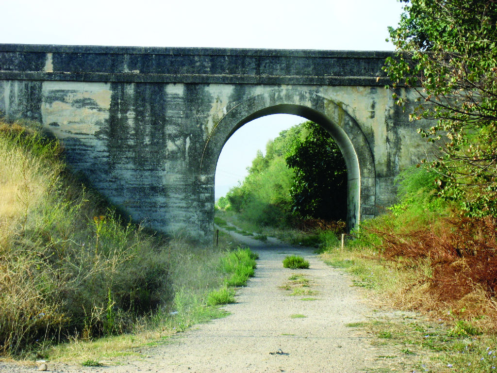
Jara Greenway Nature Trail can be explored on foot, bicycle or horse. It crosses six viaducts and eighteen tunnels. The longest measures 800 m and is located after La Nava-San Vicente Station. The remaining tunnels measure 50 to 300 m. It is advised to bring a flashlight, despite most of them are artificially lit.
The pavement and tunnels are in good repair, although some embankments have suffered slippage.
The Nature Trail continues along Las Villuercas Nature Trail, thus avoiding two flooded tunnels that are now home to a colony of bats, the area had been protected as "microrreserva Rincón del Torozo".
The best time to explore this Trail is in the spring, especially in May when the rockrose (Cistus sp.) is in bloom, or in fall. The whole route is dotted by scrub, holm oaks (Quercus ilex), a few cork oaks (Quercus suber), thyme (Thymus sp.) and many other aromatic plant species. There is also abundant wildlife, especially passerines, since large mammals often remain on the mountain slopes, avoiding the Trail.
The route begins near the Calera y Chozas railway station along the road to Talavera (CM-4101), until it crosses it and reaches the homonymous village. Immediately after the trail head is an information panel. From here (380 m), the road turns into a dirt track that runs southwest. It soon passes below one of the numerous viaducts found on this route. Immediately after, it passes through a dense reed patch, and continues straight ahead through irrigated land until the Silos railway stop, at the entrance to “El Arco” estate. Shortly after, it continues through a well-preserved Mediterranean forest located within a game preserve. Here, one can see rabbits (Oryctolagus cuniculus), hares (Lepus granatensis), different raptors and, hopefully, some deer (Cervus elaphus).
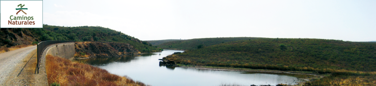
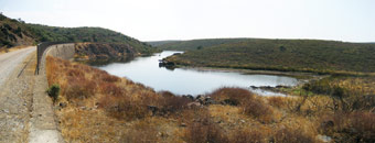
Further on the Trail, at KM 10, hidden behind a fig tree (Ficus carica) on the right side, is "Fuente de la Garrapata". Soon after the route passes through the first two tunnels. On exiting the second tunnel, a pleasant surprise awaits the traveller. A huge viaduct, confined in a steep valley, spans the River Tagus. Here the river widens to become a vast man-made body of water, the Azutan Reservoir.
Past the viaduct, the route starts to climb towards the town of Aldeanueva de Barbarroya, following a winding road that leads to Aldeanueva Station (KM 17). This is the first and only village on the route, and the only opportunity to stock up on water for the remainder of journey. From here the landscape changes. Granite is replaced by slate, and broom by rockrose, the emblematic plant of the region. The Trail continues up the River Huso, its companion to the end.
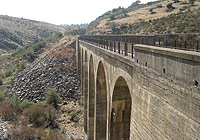
The railway stop of Pilas appears at KM 25, now converted into a partridge farm. From here to the end, the route crosses over four viaducts over the River Huso and fifteen tunnels. There are also nineteen abandoned mills along the route, many in ruins.
At KM 29, the road passes next to Nava-Fuentes Station. From here, the rockrose is increasingly dense and its intense aroma fills the air.
At KM 36, the route arrives at Campillo-Sevilleja Station. An interesting factoid about the nearby village of Sevilleja: a major Spanish imperial eagle recovery centre is located there.
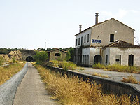
Further on from the station, the route passes near San Vicente Reservoir. It then gradually drifts away into a landscape characterised by towering embankments that confine the Trail, until it bursts forth on a sea of rockrose that will accompany the traveller during the last few kilometres. At KM 44 is located Cervilla railway stop. Framed on the north by the foothills of Sierra de Gredos and, to the south, by the road to nearby Sierra de Altamira, the route heads to the trail end (KM 52) at Santa Quiteria station (670 m), now converted into a sheep and pig farm.
Although the Nature Trail ends here, the Vegas del Guadiana Greenway Nature Trail starts further down the road to Las Villuercas . It is therefore possible to walk from Calera y Chozas (Toledo) to Villanueva de la Serena (Badajoz).
Sites of interest
Map
Puntos de Interés
Geología
Profile
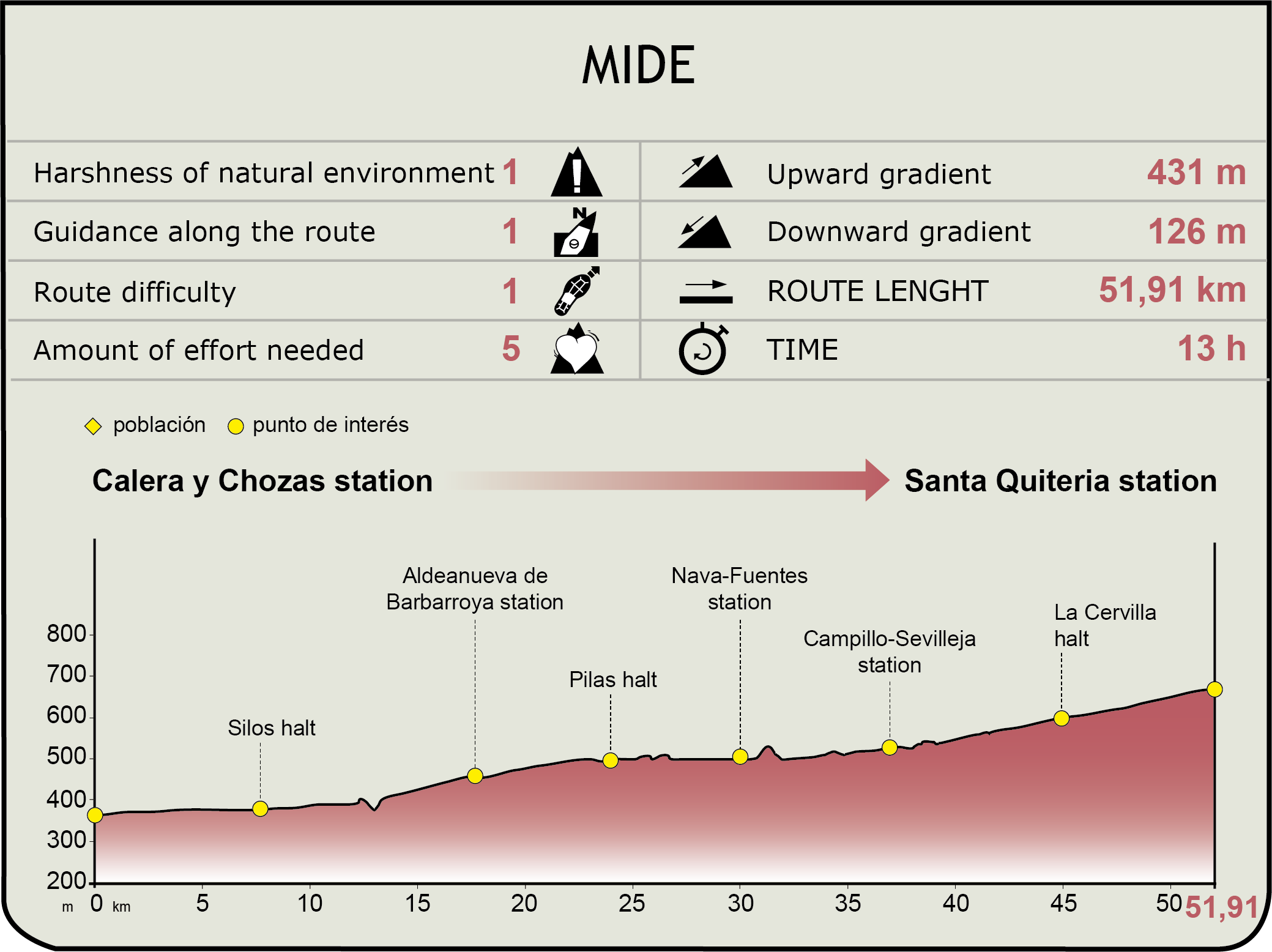
MIDE (Method for the Information of Excursions)
 Harshness of natural environment
- 1. The environment is not risk-free
- 2. There are more than one risk factors
- 3. There are various risk factors
- 4. There are quite a lot of risk factors
- 5. There are many risk factors
 Guidance along the route
- 1. Well defined trails and crossings
- 2. There is a clearly marked trail and signage
- 3. Requires the identification of geographic features and cardinal points
- 4. Requires off-path navigation
- 5. The trail is interrupted by obstacles that have to be gone around
 Route difficulty
- 1. Walking on a flat surface
- 2. Trails with different types of path
- 3. Walking on stepped paths or irregular terrain
- 4. The use of hands or jumping over the terrain is necessary
- 5. The use of hands is required to progress
 Amount of effort needed
- 1. Up to 1 hour of continuous walking
- 2. Between 1 and 3 hours of continuous walking
- 3. Between 3 and 6 hours of continuous walking
- 4. Between 6 and 10 hours of actual walking
- 5. More than 10 hours of continuous walking
Featured
Further information
Centro de Conservacion de Aves Rapaces (CERI)
A major Spanish imperial eagle (Aquila adalberti) recovery centre is located in the town of Sevilleja de la Jara. It features a nature classroom with various environmental education activities.
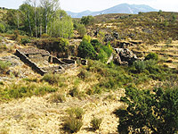
Ciudad de Vascos
These ruins attest to the existence of a large 10th century Muslim city abandoned in the 11th century, probably after the Christian conquest. It was located on a promontory over the River Huso, within the municipality of Navalmoralejo (Toledo).
It is thought that up to 3,000 inhabitants lived here. The reason for its construction and abandonment are unknown. While there is no evidence of the name of the settlement, it is thought that the term "Vascos" may be phonetic rendering of its original name.
It is very well-preserved, as it is far-removed from large urban centres. Hence, it has been less looted and its deterioration is related almost exclusively to the passage of centuries.
Multimedia