Stage 9: Las Casas - Valverde
Description
Towards the volcano, Laguna de la Posadilla
The Trail traverses through farmland of great import for seasonal migration of livestock to "Laguna de la Posadilla" Volcano, designated a Natural Monument The historical medieval-Iberian site of Alarcos, perched atop a hill overlooking the River Guadiana, is located along this route.
The Stage begins in the town of Las Casas, located eight kilometres from the city of Ciudad Real on the CM-412.
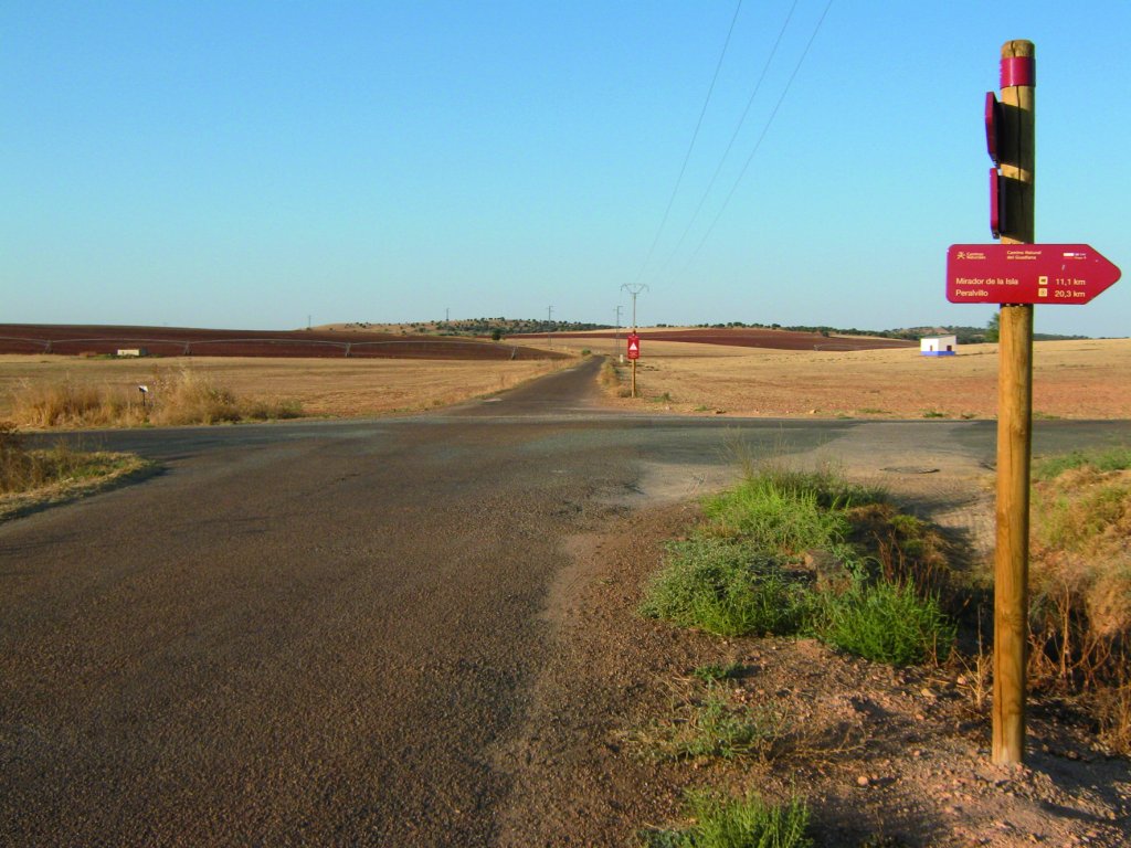
The Trail heads out of the town on a paved road shared with motorised vehicles for 2.7 km. It then continues straight ahead at the first intersection, leaving to the right the crossroads where Stage 8 ends. The landscape consists of cereal crops with olive trees and vineyards.
The route heads along a bend to the left, then continues straight to an intersection signposted with visuals of the Programme. Leaving the paved road behind, it turns onto a wide dirt road next to a ditch that leads down to the River Guadiana. Further on, to the right, is "Los Tilos" farmstead. The route disregards the access to the farm and continues straight ahead. On reaching the River Guadiana, which is blanketed with marsh vegetation, the route turns left, and then continues parallel to it.
After 2.2 km, the route skirts around "Los Corrales" stud farm, and climbs up a path leading away from the river, venturing into pastures with grazing cattle. The path reaches an overpass on the road to Ciudad Real that carries heavy traffic. Caution should be exercised when crossing to the opposite side. The route then turns right onto a wide dirt road. About 300 m further on, it merges onto a paved road. After 200 m, it reaches an intersection where it turns left. Caution should be exercised again, as vehicles access Alarcos Archaeological Park from here.
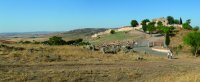
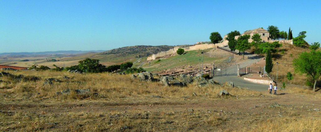
The Trail, flanked by shade trees, skirts a farm along its right side, then begins to climb up to the Shrine of Nuestra Señora de Alarcos, from where one can enjoy splendid views of this Stage. One can visit Alarcos Archaeological Park and its workshops. The car park is located half way up the slope.
From here until Valverde, Sections 9 and 10 proceed along the same route. The Trail borders the medieval walls, skirting around the hill, until it reaches a farm where it begins to descend toward the road. A sign warns that the route is shared with motorised vehicles for 400 m. The route first turns right, then after 400 m, turns left to cross a bridge over the River Guadiana, and heads towards Piedrabuena and Badajoz.
Past the bridge, a slip road to the right leads to a dirt road that climbs up towards Valverde. Part of the Trail is flanked with plane trees (Platanus x hispanica), small-leaved limes (Tilia cordata), acacia (Acacia sp.). Prior to reaching Valverde is a water tank with good views of the surroundings.
The route climbs down to a recreational area with benches, tables and a playground, where the main Stage ends.
Branch to La Posadilla Lagoon
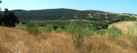
La Posadilla Lagoon is 2.7 km from the recreational area. The Trail skirts around the town of Valverde and then turns left onto a paved road whose left side is flanked by ashes (Fraxinus sp.) and small-leaf limes, as well as plots with small market gardens. Past the gardens, the Trail continues along a dirt road in very good conditions shared with the Route of Don Quixote.
Next to an olive tree grove, the Trail continues left to La Posadilla or Fuentillejo Lagoon, which is less than one kilometre away. It is a beautiful volcano with a visible lava stream and a maar (crater with a lagoon. This protected nature area has been declared "Lagunas Volcánicas del Campo de Calatrava" SCI (Site of Community Interest).
Sites of interest
Profile
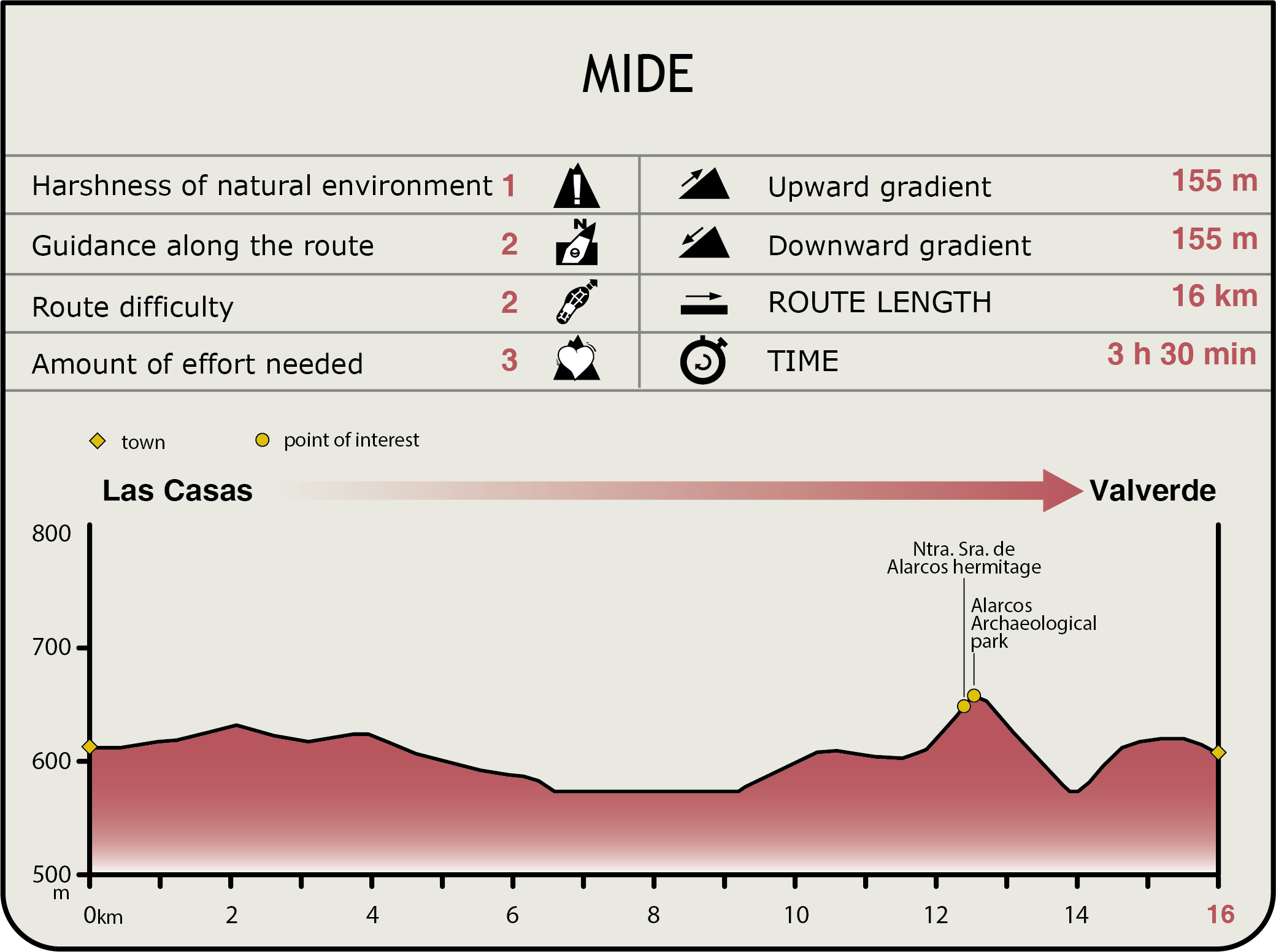
MIDE (Method for the Information of Excursions)
 Harshness of natural environment
- 1. The environment is not risk-free
- 2. There are more than one risk factors
- 3. There are various risk factors
- 4. There are quite a lot of risk factors
- 5. There are many risk factors
 Guidance along the route
- 1. Well defined trails and crossings
- 2. There is a clearly marked trail and signage
- 3. Requires the identification of geographic features and cardinal points
- 4. Requires off-path navigation
- 5. The trail is interrupted by obstacles that have to be gone around
 Route difficulty
- 1. Walking on a flat surface
- 2. Trails with different types of path
- 3. Walking on stepped paths or irregular terrain
- 4. The use of hands or jumping over the terrain is necessary
- 5. The use of hands is required to progress
 Amount of effort needed
- 1. Up to 1 hour of continuous walking
- 2. Between 1 and 3 hours of continuous walking
- 3. Between 3 and 6 hours of continuous walking
- 4. Between 6 and 10 hours of actual walking
- 5. More than 10 hours of continuous walking
Featured
Further information
Alarcos Arqueological Park
Owing to its strategic location, this was an ideal site for a human settlement. Occupied since the Bronze Age, it had two golden ages: the Iberian period and the Middle Ages.
The excavations undertaken since 1984 have brought to light part of the Iberian city, namely the outer perimeter of the castle and much of the medieval wall, which contains a mass grave with the remains of the battle fought between Muslims and Christians in 1195.
The attempt to repopulate the settlement after the Almohad occupation was unsuccessful; hence, Alphonse X founded Villa Real (Ciudad Real) in 1255, and moved all the inhabitants there. The shrine is the only reminder of Alarcos' past greatness. La Posadilla Lagoon
La Posadilla Lagoon
La Posadilla Lagoon, which covers 296 ha, is an outstanding example of a hydromagnetic explosion with a high geomorphological and landscape value. To the north of the lagoon lies a volcanosedimentary deposit with quartzite, lava and abundant pargasite fragments of different sizes. The landscape is dominated by Mediterranean vegetation, including holm oak (Quercus ilex), kermes oak (Quercus coccifera), mastic (Pistacia lentiscus) and turpentine trees (Pistacia terebinthus). The area around the lake is primarily populated with rushes (Juncus sp.).
This wetland is also a nesting site for bird species with high ecological value, including Little Grebe (Tachybaptus ruficollis), Black-winged Stilt(Himantopus himantopus), Little Ringed Plover (Charadrius dubius), and a feeding ground for species like the Black Stork (Ciconia nigra) and European White Stork(Ciconia ciconia). Notable also are several raptors that rule this area, including the Spanish Imperial Eagle (Aquila adalberti), Short-toed Snake Eagle (Circaetus gallicus), Golden Eagle (Aquila chrysaetos), and Cinereous Vulture (Aegypius monachus), all of which are included in the Castile-La Mancha Regional List of Endangered Species.
Multimedia