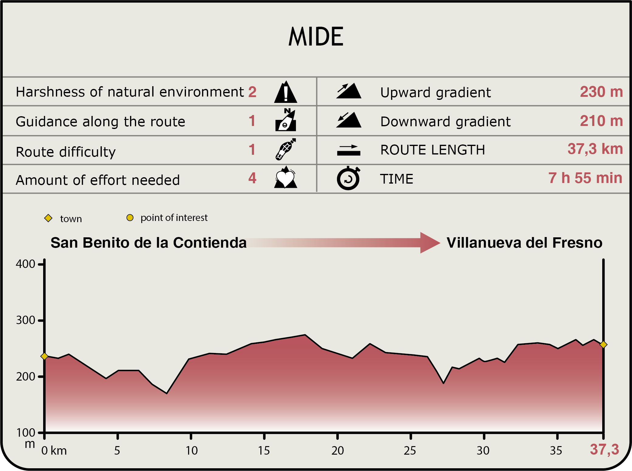
Stage 39: San Benito de la Contienda - Villanueva del Fresno
Description
Through the plains of Olivenza; the splendour of the dehesas
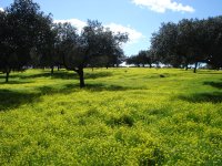
This long Stage, which is over 39 km long, includes 22 additional kilometres in alternative routes. The Trail traverses through the plains of Olivenza, a beautiful mosaic of landscapes teeming with life. The area also boasts an impressive artistic and architectural heritage, closely linked to the Alentejo's vernacular architecture. This route showcases the beauty of the dehesa in full bloom, a visual feast of colours, where one can also enjoy the rich biodiversity of bird species that populate the forests that are an integral part of the Extremaduran landscape.
This route heads out of San Benito de la Contienda, a hamlet in the parish of Olivenza, along the street known as Camino de San Benito de la Contienda. It ventures forth through a landscape dominated by vast dehesas, populated predominantly by holm oaks (Quercus ilex), and livestock farms.
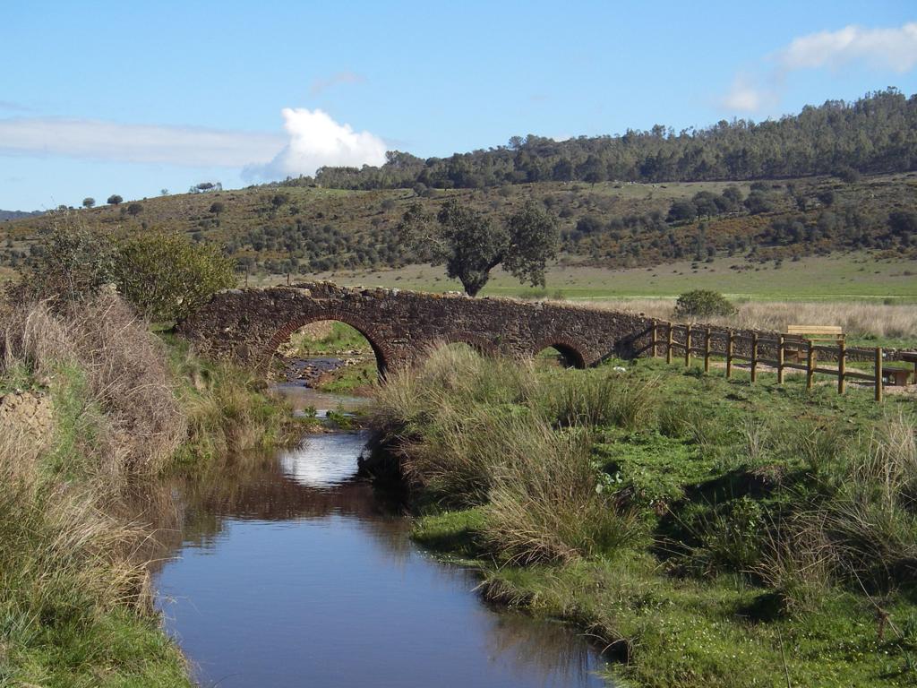
After about 5.9 km, the road reaches the gates of "El Pico" farmstead, and continues straight ahead, leaving the entrance to Cortijo Nuevo del Chaparral to the right. About 100 m further on, the route crosses a small bridge over Morenos Creek, passing next to the entrance to Montearagón farmstead. The path continues ahead, wedged in between the fences and stone walls of neighbouring dehesas, where cattle graze. The edge of the path is populated with plant species typical of Mediterranean forests, including rockrose (Cistus ladanifer and white rockrose Cistus salviifolius), yellow broom (Retama sphaerocarpa), lavender (Lavandula angustifolia) and Mediterranean gorse (Ulex parviflorus).
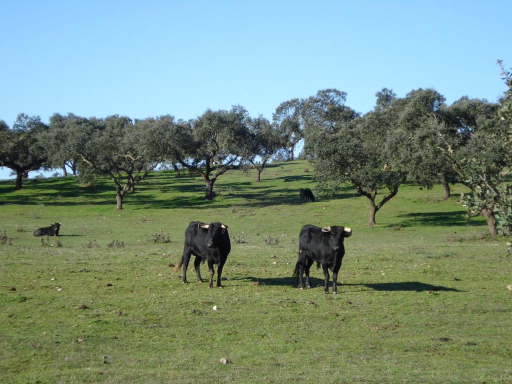
Past Montearagón, Macedos and Pombal farmsteads, the route ventures into less dense dehesas and grasslands dotted with large eucalyptus (Eucaliptus camaldulensis), stands, where fighting bulls roam freely next to the path. Past Brevera Alta, Brevera Chica and Brevera Baja farmsteads, all fine examples of vernacular architecture, the Trail traverses through a less dense holm-cork oak (Quercus suber) dehesa, with less stocking density. One can often see a large variety of raptor species in these dehesas, including Red Kite (Milvus milvus), Black Kite (Milvus migrans), Booted Eagle (Hieraaetus pennatus), Short-toed Snake Eagle (Circaetus gallicus), Black-winged Kite (Elanus caeruleus) and Common Buzzard (Buteo buteo). There are also other bird species endemic to semi-steppe and dehesa zones, including Common Hoopoe (Upupa epops), Green Woodpecker (Picus viridis), White Stork (Ciconia ciconia), Chaffinch (Fringilla coelebs), and Woodchat Shrike (Lanius senator), that rely on this ecosystem for food. The ornithological diversity of the dehesa is enriched further in winter with the arrival migratory Common Cranes (Grus grus), Woodpigeons (Columba palumbus), and Northern Lapwings (Vanellus vanellus).
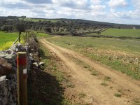
Past this stretch, the Trail runs parallel to Ribera de Táliga River, with sweeping views of vast grasslands combined with riparian vegetation, including oleander (Nerium oleander), ash (Fraxinus angustifolia), poplars (Populus sp.) brambles (Rosa sp.), and other indigenous Mediterranean shrubs, such as yellow broom and rockrose. About 1 kilometre further on along the riverbanks, before Zapillo farmstead, the path drifts away from the river and continues straight ahead for 800 m to the intersection with "Camino de los Molinos".
The alternative route that links the Nature Trail with Alconchel begins here. However, Stage 39's main route continues to the right, along a path flanked by small stone walls, leading towards Cheles and Villanueva del Fresno.
A few metres ahead, to the right of the path, at a site known as El Zapillo, is one of many ponds that dot the route. These ponds collect rainwater, and serve as a watering hole where cattle and other wildlife species quench their thirst, especially at sunrise and sunset. They are perfect places for watching birds and wildlife.

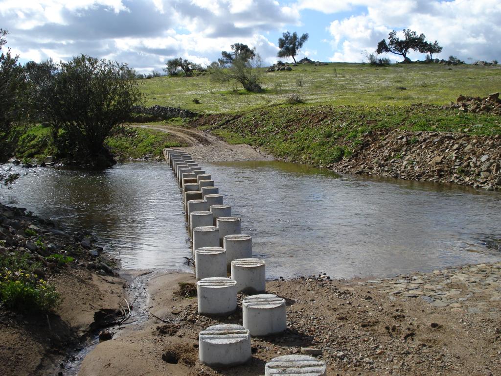
About 700 m further is the Ribera de Táliga River, whose waters sustained the livelihood of several families working at the local mills. Concrete stepping-stones cross the stream. As the sign indicates, caution should be exercised at this point. One can see up close the rich riparian vegetation on the banks of these calm waters, which bring great ecological value to this small stream.
The route continues to venture further into a purely Mediterranean cork oak dehesa landscape, dotted with shrubs, including yellow broom, Mediterranean gorse, asphodel (Asphodelus sp.) and rockrose, and a blanket of wild herbs which bloom in a riot of colour in spring.
One may come upon a few free-roaming cattle grazing in these forests impacted by human activity; therefore, one must make sure that gates and fences are properly closed. After crossing several gates, and past a few entrances to private farmsteads, one can see to the right an old well next to Siete Fuentes Creek, whose seasonal waters feed the Táliga. Further beyond is the Cortijo de la Peña farmstead.
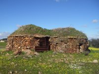
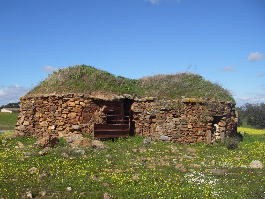
Further on, there are three round, stone "chozos" (shepherd huts) to the right, relics of traditional folk architecture, built in a privileged setting, where the gentle, rolling terrain offers a sweeping view of a natural mosaic.
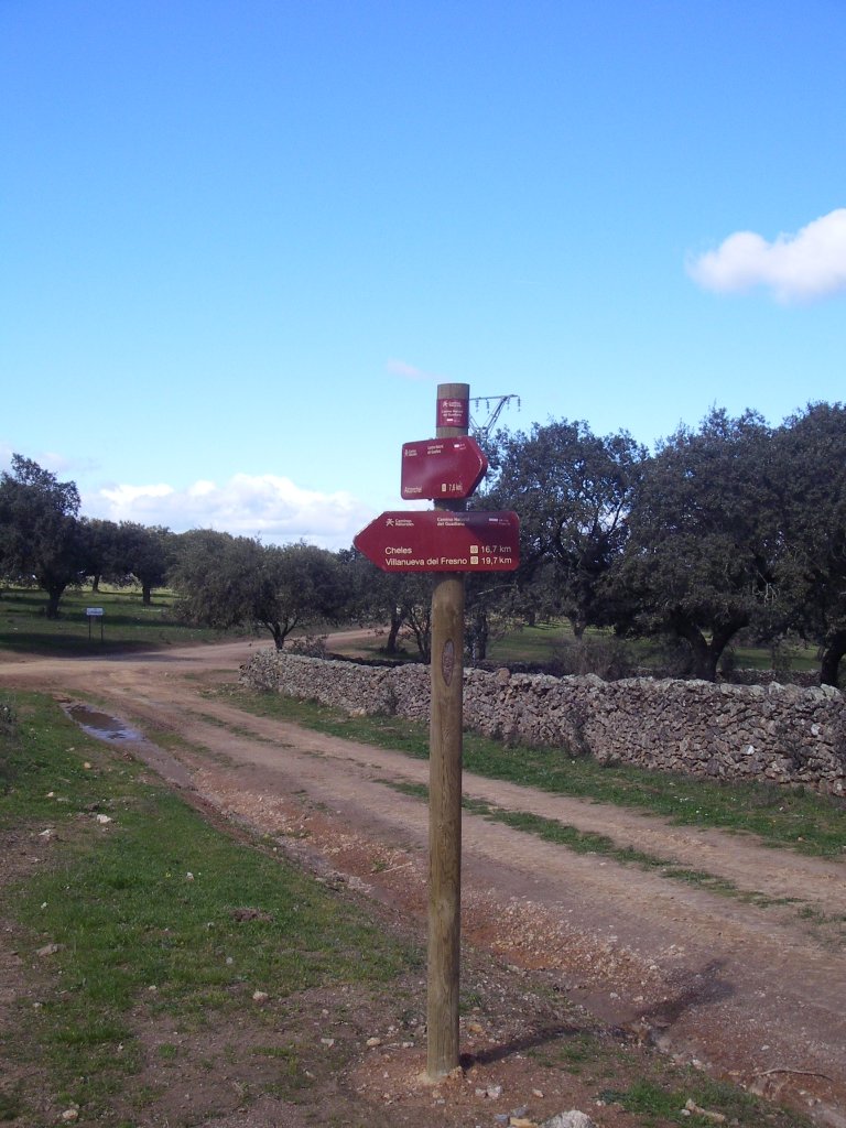
The route arrives soon later at an intersection with the road leading to La Esparragosa farmstead. As the sign on the road indicates, the route turns left towards Cheles and Villanueva del Fresno. The holm oak ecosystem along the Trail continues to yield surprises. One can spot Red-legged Partridges (Alectoris rufa), rabbits (Oryctolagus cuniculus) aand a large variety of birds. Past several intersections in which the route continues straight ahead, the Trail crosses the EX-314.
Further on, it passes next to several cattle grids and conveniently marked crossroads, until it reaches the intersection with a path known as Martín Vaca. The right path leads to the alternative route to Cheles, whereas the left path leads to the town of Villanueva del Fresno.
The route to Villanueva del Fresno leads to a bridge over Rivera de Friegamuñoz River, from where one can see the old Moncarche Bridge and the remains a former Franciscan monastery, carved into the rock, which dates back to 1501. One can also see the ruins of an aqueduct that supplied water to the Convent of Nuestra Señora de la Luz.
The Stage ends at Villanueva del Fresno, a town that sits on the opposite side of EX-112. Worthy of note is the town hall at Plaza de España, a majestic building in neoclassical style, and the parish church of Nuestra Señora de la Concepción. There are also three shrines, devoted, respectively, to Cristo de la Expiración, San Antonio and San Ginés de la Jara. The statue of this latter saint is displayed in a procession on the first Sunday of May.
Owing to the type of terrain around Villanueva del Fresno, wild mushrooms grow in abundance. Indeed, the town hosts several food and craft festivals relating to the "gurumelo" Amanita ponderosa.
Alconchel Branch
At the "Camino de los Molinos", one may choose to travel the 3-kilometre alternative route that runs towards Alconchel, parallel to Rivera de Táliga River.
The river and its rich riparian vegetation serve as a guide for this alternative route. During the first kilometre, it traverses through farms where pigs, cattle and horses are raised on open ranges. It continues to a site known as Dehesa del Agregado, where the Casa Huerta del Conde sits. One can see to the left a round shepherd's "chozo" with a thatch roof in perfect conditions, as well as two derelict chozos. To the right are San Pedro and Balsa hills, blanketed with oaks and pastures, with the remains of the Convent of San Pedro in their midst. On the opposite side are Esperanza and El Ejido hills, with eucalyptus-covered slopes.
The route continues until it reaches a rest area (left) located at the Km 2 milestone, next to the medieval "Carrasco Bridge", built over one of the many creeks that empty into Rivera de Táliga River. Three original brick and masonry arches still stand. From here, the landscape on both sides of the road is increasingly devoid of trees, with a higher sheep and goat stocking density..
Past the intersection with the paved road to the cemetery, the route ventures down Cruz Street in Alconchel, lined with whitewashed houses with Arabic roof tiles and baseboards of different colours, which reveals the Portuguese influence. There is also an information panel, and a few metres further on, a sign indicates the end of the route.
Cheles Branch
To continue along the Cheles Alternative Route, the Trail must turn right before reaching Villanueva del Fresno at the intersection mentioned above. The landscape is still dominated by holm oak dehesas, with free-roaming cattle, and almost flat terrain.
Although dense undergrowth begins to appear five kilometres into the route, the ubiquitous holm oak is still king.
After fording a small creek, the landscape changes to a vast countryside with fields of grain, where partridges abound.
Once in Cheles, one can visit the namesake beach located some 5 km from the town. This beautiful venue has picnic areas, a children's playground and a beach bar where one can enjoy a pleasant day.
From the centre of Cheles, skirting around the right side of the shrine of the Santo Cristo de la Paz, starts another paved road that leads to the pier, from where one can enjoy stunning views of the River Guadiana. The area has been designated as "Río Guadiana y Ribera del Chanza" SCI (Site Community Interest) for its natural interest.
Sites of interest
Profile
MIDE (Method for the Information of Excursions)
 Harshness of natural environment
- 1. The environment is not risk-free
- 2. There are more than one risk factors
- 3. There are various risk factors
- 4. There are quite a lot of risk factors
- 5. There are many risk factors
 Guidance along the route
- 1. Well defined trails and crossings
- 2. There is a clearly marked trail and signage
- 3. Requires the identification of geographic features and cardinal points
- 4. Requires off-path navigation
- 5. The trail is interrupted by obstacles that have to be gone around
 Route difficulty
- 1. Walking on a flat surface
- 2. Trails with different types of path
- 3. Walking on stepped paths or irregular terrain
- 4. The use of hands or jumping over the terrain is necessary
- 5. The use of hands is required to progress
 Amount of effort needed
- 1. Up to 1 hour of continuous walking
- 2. Between 1 and 3 hours of continuous walking
- 3. Between 3 and 6 hours of continuous walking
- 4. Between 6 and 10 hours of actual walking
- 5. More than 10 hours of continuous walking
Featured
Further information
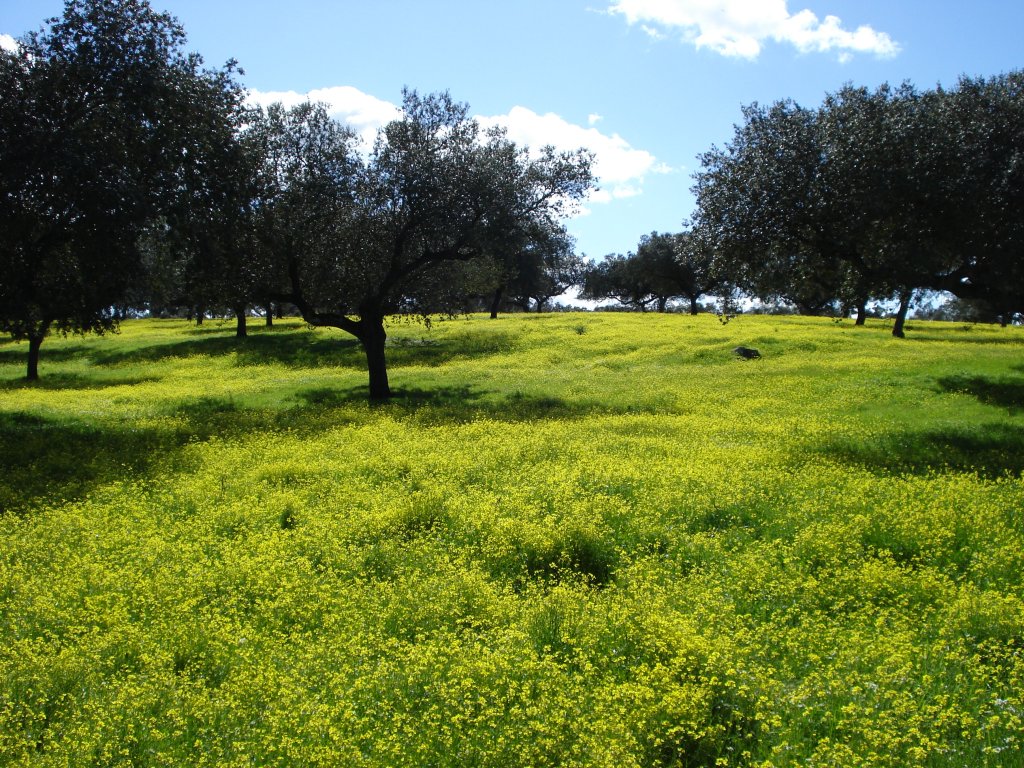
Dehesa
The term derives from the Castilian word defensa (defence). According to the RAE (Royal Academy of the Spanish Language), dehesa is defined as a "delimited plot of land, usually intended for pasture". It is indeed the most characteristic landscape of several regions across the Iberian peninsula, including Extremadura. It accounts for almost one-third of the region's area.
This ecosystem is characterised by scattered trees, usually holm or cork oak, and lack of undergrowth, which form pastures and croplands, where agriculture, including livestock farming, and forestry have coexisted for millennia. Indeed, the Romans already had a sustainable agro-silvopastoral system.
The dehesa benefits society with its high quality products, increasingly sought by the markets. Hardy indigenous species, including the Iberian pig, Merino sheep and Retinto cow, skilfully exploit the natural resources of these ecosystems, usually located on siliceous rocks (primarily, shale and granite), and the Mediterranean climate characterised by hot dry summers and long, mild winters. Hunting, acorn and cork production, breeding of fighting bulls and a growing eco-tourism are but a few of the possibilities offered by these forests.
Currently, the dehesas are facing several challenges, including overgrazing, lack of regeneration of woodland stock and, above all, bot canker of holm oak. In fact, there are several guidelines dealing with the protection and conservation of these ecosystems that harbour high biodiversity, and are part of our natural, landscape and cultural heritage.
Moncarche Bridge and the former convent of Nuestra Señora de la Luz
Built on the banks of the River Friegamuñoz, the aqueduct attached to the side of the bridge is worthy of note. In bygone days, it carried water from a nearby fountain to the former convent of Nuestra Señora de la Luz, located on the opposite bank, in the town of Alconchel. In 1715, the friars decided that it would be convenient to have a supply of water within the convent. To that effect, they used the existing bridge to build a gravity-fed aqueduct to carry water from a fountain on the opposite riverbank.
Alconchel's former convent of Nuestra Señora de la Luz was commissioned by Juan de Sotomayor, Lord of Alconchel, shortly before 1500. It was delivered to Friar Juan de Guadalupe in 1501. It is one the first convents founded by the Franciscans in this area. Indeed, the structure is true to the typical, austere Franciscan style. The chapel is carved into the rock, with the bell tower and guesthouse next to it.
Although the building is now in ruins, the inhabitants of Alconchel make an annual pilgrimage (Romería de los Jarales) to this former convent on March 19th.
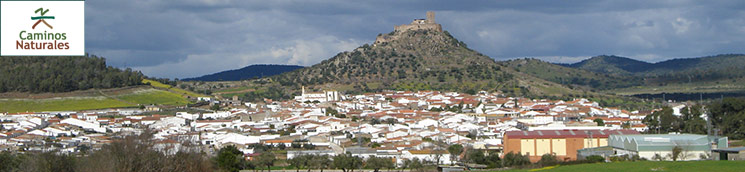
Miraflores (or Coluche) Castle
The majestic castle of Miraflores, or Coluche, is located north of Alconchel on Miraflores Hill (296 m above sea level). Although of Arab origin, the castle was rebuilt in the twelfth century by the Portuguese King Alfonso Enriquez. It was seized in 1264 by Castile, first under the Order of the Templars and, subsequently, the Order of Alcántara. It was one of the most powerful strongholds along the Spanish-Portuguese border. It underwent successive reforms in the fourteenth century, making it one of the most important strategic castles. The defence system was overhauled in the sixteenth century to accommodate artillery and heavy weapons. It belonged to the Marquis of San Juan de Piedras Albas and Bélgida from 1690 until the nineteenth century.
The castle originally consisted of three enclosures, dominated by a massive watchtower, a large parade ground, a cistern, dungeons, a chapel and other rooms of which the ruins can be seen. It currently houses the Fortresses Interpretation Centre. It is also being refurbished into a congress centre with accommodation.
The whitewashed houses of Alconchel lie at the foot of the castle, including historically important buildings such as the 16th-century parish church of Remedios in Renaissance-Gothic style; the Plaza Mayor or "Terrero" with beautiful street lamps, home to the town hall; and the former public prison (17th c.), which is today the Alconchel History Museum.
Multimedia