Stage 21: Herrera del Duque - Puerto Peña
Description
Through the Extremaduran Siberia, along García de Sola Reservoir
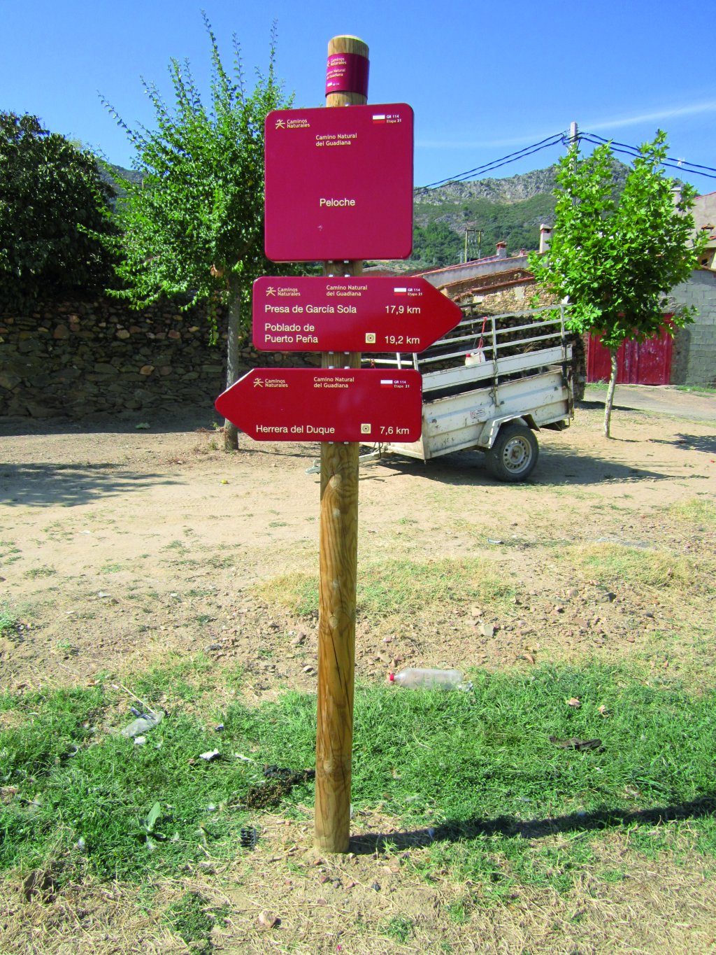
This Stage links the Guadiana Nature Trail with García de Sola Reservoir, whose tail is located near the Cíjara Reservoir Dam. The route begins in the centre of Herrera del Duque, and runs entirely along the BA-138, toward the reservoir. It passes next to two river beaches, Peloche and Puerto Peña, equipped with public use infrastructures.
Stage 21 starts at Herrera del Duque, and runs entirely along the BA-138 that links this town with Puerto Peña. This Stage runs along the south side of García de Sola Reservoir, focusing on its botanical and landscape values. The views of the water dominate the landscape throughout the route.
The Stage begins at Avenida de las Palmeras, a wide street with restaurants and a small urban park, an ideal location for getting some rest if one has just completed the previous Stage. It also features information panels on the main cultural values of the town and the region. There is also a street map to navigate through the town, as there no signs in the town centre.
Leaving the town behind, and travelling always along the road leading to the endpoint, the Stage ventures through an open oak (Quercus ilex) dehesa on grass, with a few, scattered farm buildings. Sierra de los Golondrinos dominates the landscape to the left. The higher reaches are covered with holm oak forests, and the lower sections with olive trees. Alone or in small groups, forming neither stands nor dehesas, the cork oak (Quercus suber) characterises the landscape. This first part of the route ventures through “Puerto Peña-Los Golondrinos” SCI (Site of Community Interest). Towards the end of the Stage, the route traverses through “Embalse de Orellana y Sierra de Pela” LIC and two namesake SPAs (Special Protection Area for Birds). It should also be noted that “Embalse de Orellana y Sierra de Pela” has been designated an Area of Regional Interest.

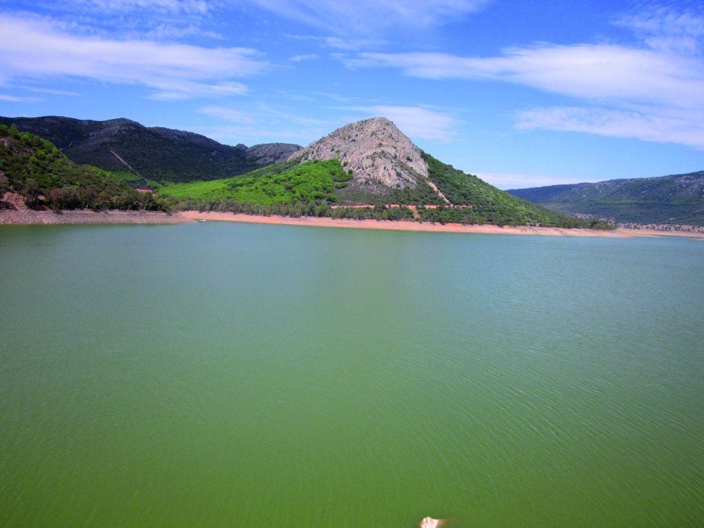
Before reaching Peloche, one can see García de Sola Reservoir to the right of the Trail. The mouth of Zarza Creek is situated a couple of kilometres before the town. From here, one can enjoy the beautiful view of the town in the distance, framed by the last foothills of Sierra de Peloche and Peña del Risco, on the opposite side of the reservoir.
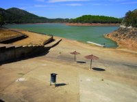
There are several, wide natural river beaches in Pedroche, equipped with various facilities for public use. As in much of this Stage, the views of the reservoir from Peloche are dominated by Peña del Risco and Peloche Mountain Range, which towers behind the namesake town.
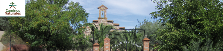
Past Peloche, the next place of interest is the Shrine of Virgen del Espino, where one can stop at a small rest area with a fountain. From here, the Stage runs along the banks of the reservoir.
There are two must-see places in the first half of the route along the reservoir. The first one is next to the “El Solitario” housing development; a few scattered houses immersed in vegetation that barely disrupt the landscape. This is where the Trail comes closest to Peña del Risco, with outstanding views of the reservoir. The second site of interest is located at the foot of Corchito Hill. A terrace next to the road, laid out as a car park enclosed by a stone wall to avoid the risk of falling, serves as a viewpoint. One can see Peña del Risco and Sierra del Manzano from a different perspective. This terrain affords an unbroken view of Sierra del Oro to the south, where this rock sits.
Dense woods of holm oak dominate the slopes around the reservoir, interspersed with rockrose (Cistus sp.) or heather (Erica sp.) thickets depending on the sun exposure. Of particular interest is the stretch at the foot of the south slope of Corchito Hill, where the Trail ventures through willows (Salix sp.), some of which are very tall.
Further on, the Trail drifts away from the reservoir, to the extent that it completely disappears behind Horbezuela Hill. The road continues along a wide, straight stretch, with an open holm oak dehesa to the left, overshadowed by Alguaciles Hill. Here appear the first stands of stone pine (Pinus pinea) on the summits, clearly distinguishable by the bright green of its foliage, lighter than the holm oak, scrub or willow.
Near the end, there are two bridges over which the road crosses a branch of the reservoir. The older bridge, with wooden benches on the deck, is exclusively pedestrian, thus avoiding having to share the road with motorised vehicles.
The Stage ends at Puerto Peña Beach, equipped with bathing facilities, a pier and a recreation centre with a cafeteria, toilets and picnic area.
Sites of interest
Profile
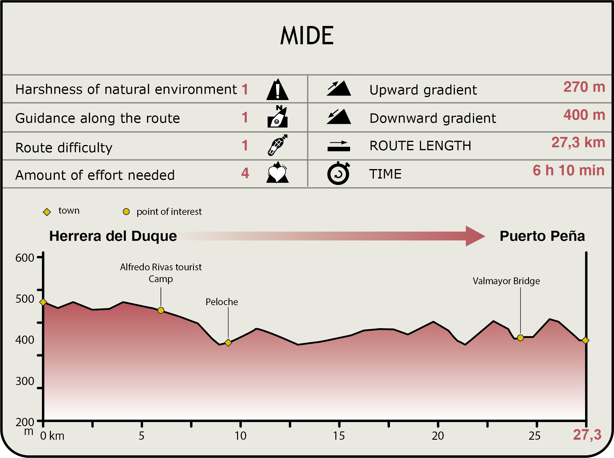
MIDE (Method for the Information of Excursions)
 Harshness of natural environment
- 1. The environment is not risk-free
- 2. There are more than one risk factors
- 3. There are various risk factors
- 4. There are quite a lot of risk factors
- 5. There are many risk factors
 Guidance along the route
- 1. Well defined trails and crossings
- 2. There is a clearly marked trail and signage
- 3. Requires the identification of geographic features and cardinal points
- 4. Requires off-path navigation
- 5. The trail is interrupted by obstacles that have to be gone around
 Route difficulty
- 1. Walking on a flat surface
- 2. Trails with different types of path
- 3. Walking on stepped paths or irregular terrain
- 4. The use of hands or jumping over the terrain is necessary
- 5. The use of hands is required to progress
 Amount of effort needed
- 1. Up to 1 hour of continuous walking
- 2. Between 1 and 3 hours of continuous walking
- 3. Between 3 and 6 hours of continuous walking
- 4. Between 6 and 10 hours of actual walking
- 5. More than 10 hours of continuous walking
Featured
Further information
Herrera del Duque
Located on the south slope of Consolación and Chamorrol mountain ranges, this town has changed its name multiple times depending on the period and its inhabitants. The current name was used for the first time during the reign of Charles III.
Notable is the 15th-century Church of San Juan Bautista. The additions made in different periods are clearly visible in the different styles used. The façade with Moorish arches and two Gothic doors are of particular interest. On the west wall is a square, brick tower with hipped roof and a belfry. The building is divided into three Renaissance naves and a vaulted chapel.
The castle-fortress was built during the Arab rule, and subsequently rebuilt by the Military Order of Calatrava. Built atop a rocky hill, it commands an excellent strategic position to control the territory. From here, one could control the crossroads of the main roads linking Merida with Ciudad Real, Toledo and Seville from the fortress.
The building is a stone and masonry castle-palace with an irregular polygonal plan. The main walls are more than 12 m high. The fortress is accessed through a complex door framed by a large brick arch. Although the sentry walks on the ramparts can still be seen, the barbican, moat, cistern and keep have disappeared. The castle is listed as a Site of Cultural Interest.
The medieval bridge, or Puente Viejo, is located outside the town, over Peloche Creek. It is 49 m long and has 8 arches in descending order. The stone bridge has triangular breakwaters that protect the bridge against floods. The parapet has almost completely disappeared. However, the road paved with river pebbles is still in perfect conditions and used as a livestock crossing.
Multimedia