
- Home
- Rural Development
- Nature Trails
- Nature Trails
- Central Sector
- Agua Soriano. Camino Antonino
Stage 4: Muro - Vozmediano
Description
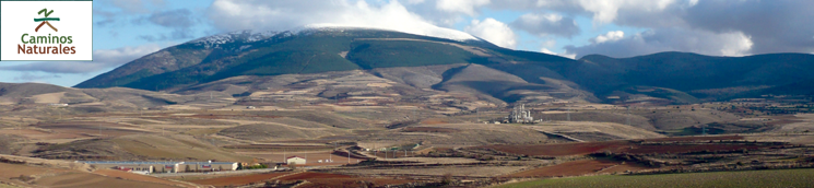
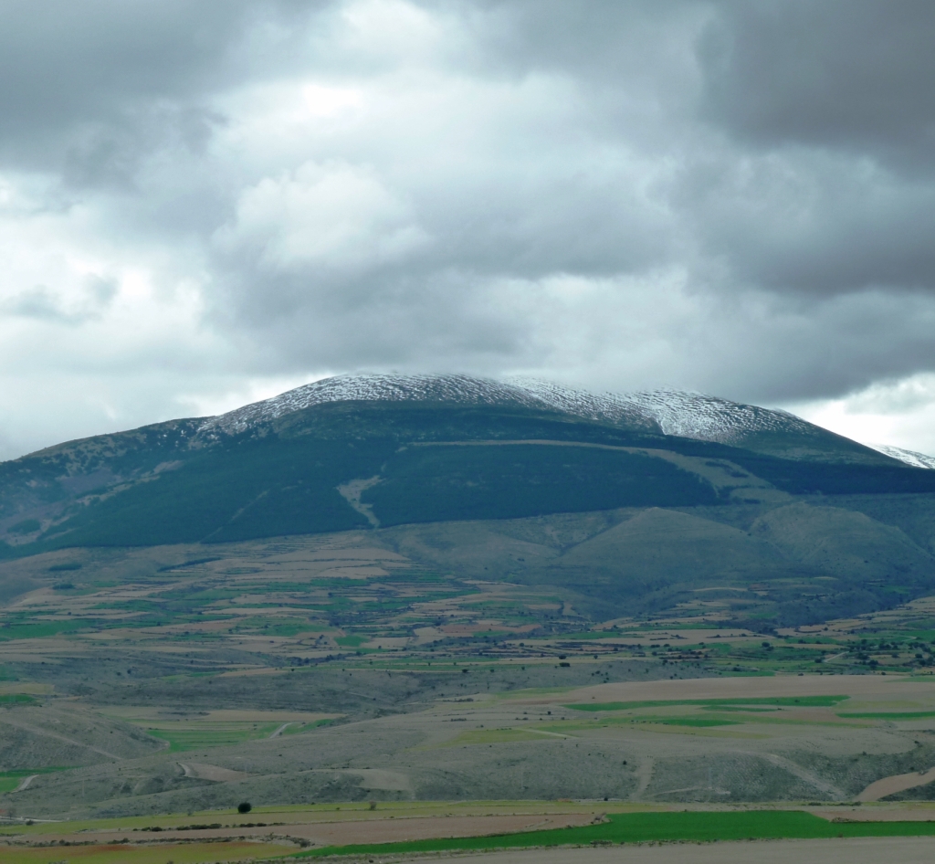
The Moncayo
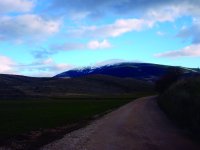
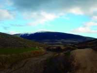
This fourth stage of the Nature Trail follows the Antonine Itinerary Iter XXVII for 16 km through the province of Soria, from Muro to Vozmediano, witness to the feuds between the kingdoms of Castile and Aragón, passing through Agreda.

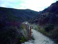
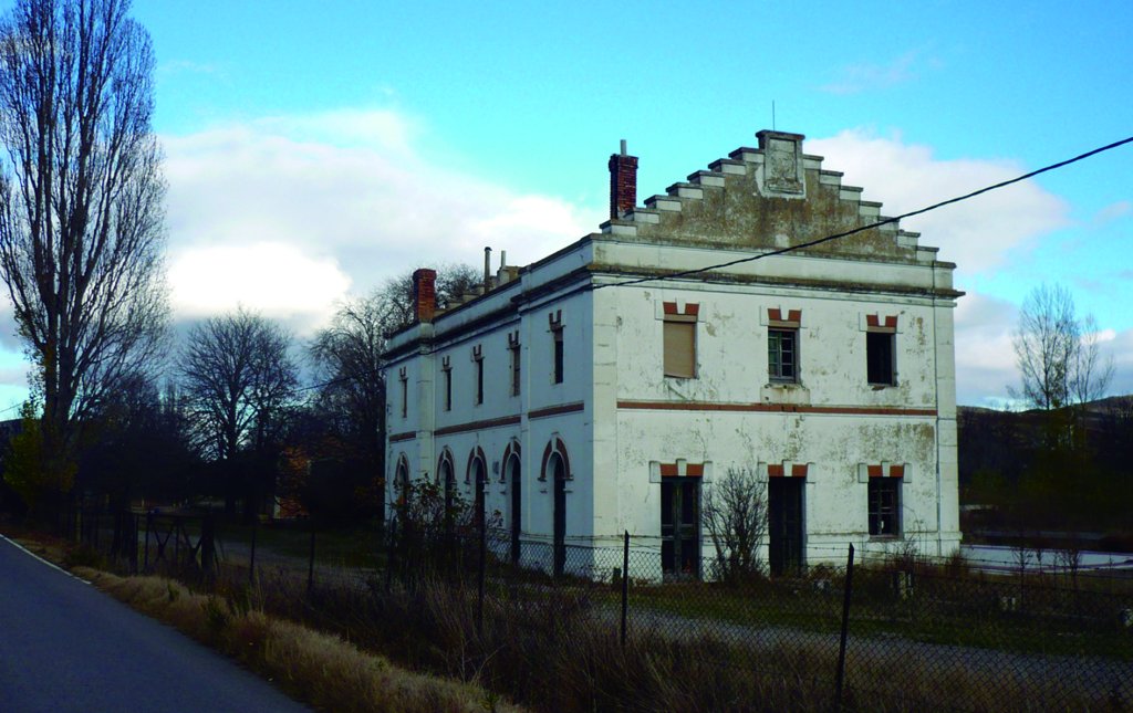
Muro, located about 1,000 m up a hillside in the hollow between the Madero and Moncayo mountain ranges, is the trail head of the fourth section of the Agua Soriano-Camino Antonino Nature Trail. This route starts on the outskirts of the town, along the road to Agreda, which runs over the Roman road. As in the previous section, this stretch of the Trail follows Iter XXVII, whenever possible, although it is barely discernible.
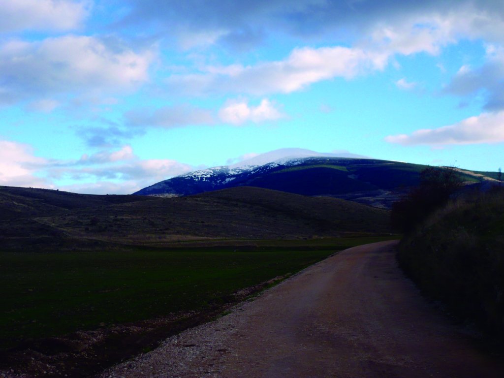
About 1.5 km from Muro, in Valdeabejas gully, the route continues along the path leading to Alto de la Taraviela. At an altitude of 800 m, this is an excellent vantage point for viewing the surrounding mountains, among which is the Moncayo (2,315 m), the highest peak in the range and a visual reference throughout the route.
Retracing the path back to the fork, the route continues for a little over two kilometres to the intersection with C-101, which it crosses through an underpass, to connect with the former road to Olvega that leads to the centre of Agreda.
Ágreda
The city of Agreda is located in the plains of the River Cailes, also known as River Val, where fields of cereals, sugar beet, sunflower, corn and alfalfa are dotted with small horticultural gardens and a few trees, mainly holm oak (Quercus ilex), common oak (Quercus robur) and reforestation pine (Pinus sylvestris) trees. The village borders to the southeast with the slopes of the Moncayo, and to the northwest with a line of hills which cover much of its rugged terrain.
Arabs, Jews and Christians immortalised their presence in Agreda, also known as "the city of the three cultures”. Coveted by Castile, Navarre and Aragón, Agreda was conquered in 1118 by King Alphonse I the Battler. It still preserves important vestiges of the past in many civilian and religious buildings.
The remains of the wall, two Emir's gates and La Muela Tower remind of its Arab past. The tower was built on the outskirts, perched on a cliff above the Queiles ravine, in a place where Agreda’s roots run deep. The Puerta del Agua, a horseshoe arch entrance to the citadel, the military compound that guarded the entrance to the Ebro Valley, and the Puerta del Cementerio or Emir's Arch, ninth century, which gave access to the Arab city and was situated opposite the hill used as a Muslim cemetery.
The wall paintings, which have been restored, and the viewpoint over the terraced vegetable gardens designed by the Moors, are all that remains of the Arab neighbourhood. There is also a fountain oriented towards Mecca, a vestige of the irrigation system used by the Arabs. The layout of the former Jewish quarter can still be seen near the Arab quarter. Deeper knowledge of this legacy can be acquired by visiting the city's interpretation centre.
Three more walled enclosures were built following the Christian resettlement of Agreda in the Middle Ages. All four walled enclosures were independent from each other, but were connected by gates and defended by towers. Examples of these defences include the Torre del Tirador, the Torre de Almazán, which gave access to the San Miguel walled enclosure, and the Tower of Santiago, through which one could access Nuestra Señora de la Peña enclosure, where today stands its namesake church, one of few Romanesque churches with a double nave. It was renovated in Gothic style during the fifteenth and sixteenth centuries. Since 2002, it houses the regional Museum of Sacred Art.
Within the walled enclosure of La Peña, on a street in the former Jewish quarter, still stands the ancient synagogue and two gates, Puerta de Santo Domingo and Puerta de los Pilares, which gave access to the citadel of Castejón, so-named for one of many noble families that settled in Agreda during the sixteenth and seventeenth centuries. In the ancient citadel of Castejones, there are two large 16th century mansions that were part of the palace complex built by this family. The City Hall, in Renaissance style, is also from the sixteenth century.
The Palace of the Castejones is situated within the San Miguel walled enclosure. This fifteenth century Renaissance building is one of few garden-palaces of that period. The Jardín Renacentista of Don Diego González de Castejón and the Jardín de la Memoria can still be visited today. The Gothic church of San Miguel, with a 12th century Romanesque tower, and the convent-museum of the Venerable Sor María de Jesús, who ordered it built in the seventeenth century, can also be visited. Born in Agreda in 1602, María Coronel y Arana was not only a mystic, writer and saint, but also a confidant of King Philip IV and one of the most influential women of her time.
The walled enclosure of San Juan, the largest of the four, is home to the Basilica of Nuestra Señora de los Milagros, built in the sixteenth century by the Augustinian order, and one of the finest examples of religious Sorian architecture of that century. It also contains the churches of Nuestra Señora de Magaña and of San Juan Bautista, the Puerta de Añavieja and the Costoya Tower.
After visiting this invaluable historical and cultural heritage, the route leaves Agreda through Parque de la Dehesa, one of the most visited tourist attractions of the city.
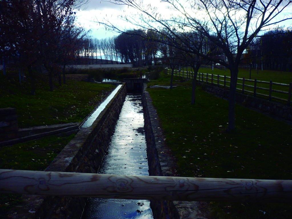
Los Ojillos del Val
At the end of Parque de la Dehesa, the Nature Trail reaches Los Ojillos del Val, a wetland where the River Val rises to the surface as springs. The River Val, or Cailes, is a tributary of the River Queiles, which rises in Olvega, fed by spring water from Mount Moncayo. The permeability of the rocks and the gentle slope of the river in its first stretch causes the Val to disappear and reappear in Agreda at Los Ojillos del Val, where it flows to the surface at a rate of 50 L per second.
From Los Ojillos del Val, the route continues about 4 km up the trail to Cañada Rosa Ravine, where it meets the path to Cuesta Mala. Further on, after a little more than one kilometre, is the intersection of Los Cuatro Caminos, where the trail turns onto the road to Aldehuela de Agreda.
Aldehuela de Agreda
Little more than 1,000 m up the slopes of the Moncayo is Aldehuela de Agreda, a mountain village with a harsh climate and few inhabitants. This town, located in the municipality of Agreda, is home to the church of San Lorenzo, a 17th century building with a small single nave, two side chapels and a tower. The statue of the Cristo del Perdón graces the altar, and to the sides, in two niches, are the baroque statues of San Lorenzo and San Ramon Nonato.
In the church square, the route continues north along Mayor Street towards the edge of town, where it turns northeast onto the road to Vozmediano. The course now heads east, following the milestones, and soon after, starts a steep descent into Queiles Ravine.
After crossing the river, the path continues to the headwaters of the River Queiles, and from there to Vozmediano. Here ends the fourth section through the Land of Agreda, profoundly marked by the presence of the majestic Moncayo.
Profile
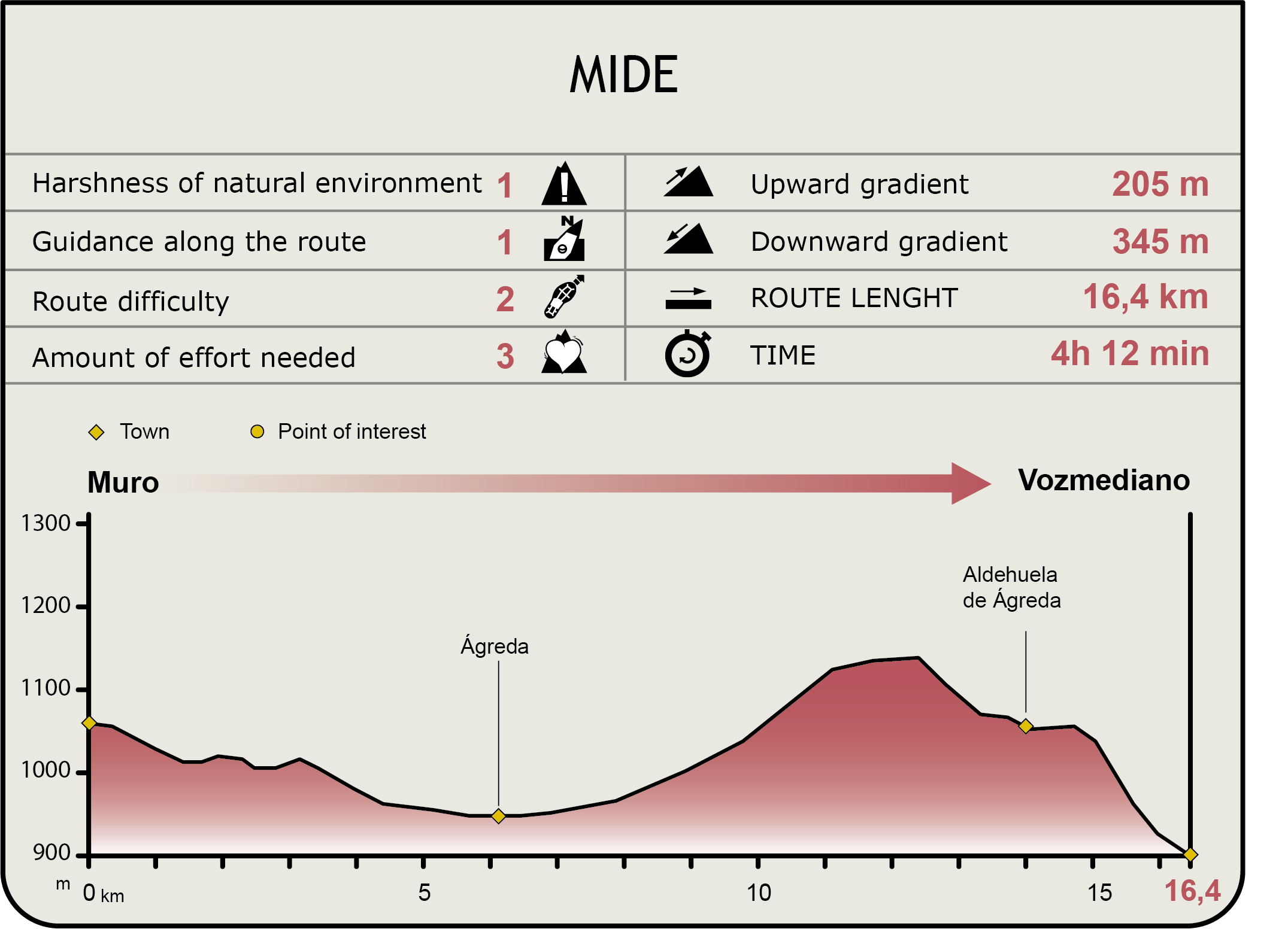
MIDE (Method for the Information of Excursions)
 Harshness of natural environment
- 1. The environment is not risk-free
- 2. There are more than one risk factors
- 3. There are various risk factors
- 4. There are quite a lot of risk factors
- 5. There are many risk factors
 Guidance along the route
- 1. Well defined trails and crossings
- 2. There is a clearly marked trail and signage
- 3. Requires the identification of geographic features and cardinal points
- 4. Requires off-path navigation
- 5. The trail is interrupted by obstacles that have to be gone around
 Route difficulty
- 1. Walking on a flat surface
- 2. Trails with different types of path
- 3. Walking on stepped paths or irregular terrain
- 4. The use of hands or jumping over the terrain is necessary
- 5. The use of hands is required to progress
 Amount of effort needed
- 1. Up to 1 hour of continuous walking
- 2. Between 1 and 3 hours of continuous walking
- 3. Between 3 and 6 hours of continuous walking
- 4. Between 6 and 10 hours of actual walking
- 5. More than 10 hours of continuous walking
Featured
Further information
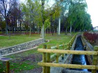
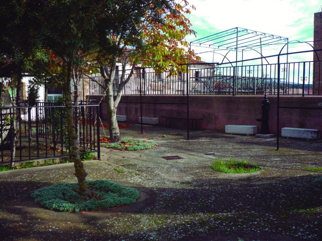
Parque de la Dehesa
Agreda's Parque de la Dehesa is a large green area used by visitors and locals for recreation and walks. Following the Christian conquest, the town was occupied by the Order of Hospitallers of St. John of Jerusalem, Knights of Malta. It served as supply point for the Templar settlement.
During the reign of King Alphonse X the Wise, these pastures helped the economy of the poorest farmers. The town later declared this area communal land. For a long time, it was an agricultural centre and a cattle pasture.
In the eighteenth century, the meadow was transformed into the leisure and recreational green area that it is today, with rows of trees and various walking routes. The Parque de la Dehesa is currently divided into three walking areas, the first of which is the Moisés Calvo Park with a bandstand.
The second area is the Intendente, which consists of a vast meadow and the largest expanse of horse chestnut (Aesculus hippocastanum) trees in Europe ranged in rows. This walking route also has a fountain of sulphur water with medicinal properties, recognisable by its “rotten egg” smell, and a garden of centennial trees.
The third route is the most popular. It includes a beautiful wooded area with different species arranged in rows, stone and wood tables, fountains, barbecues and a large green area.
The headwaters of the River Queiles
The River Queiles rises southwest from Vozmediano, at an altitude of about 1,000 m. The water from the Moncayo gushes forth, erupting explosively and noisily from a cave. The enormous force and pressure of the water, about 1,500 L/s, make the River Queiles’ head spring the most spectacular in Europe.
A “vauclusian spring” or “intermittent spring”, as these types of springs are known, is a pre-existing watercourse that has disappeared into a permeable, water-bearing stratum, seeping through fissures or diaclastic rocks, only to emerge subsequently at the surface. This is the case of the River Araviana, which rises in the River Douro basin, and then naturally transfers to the River Ebro basin from its headwaters, emerging again in Vozmediano.
The Araviana emerges in the boundary between the Douro and Ebro watershed, within the circle drawn around the Moncayo massif, which, by virtue of its height and location, is an important source of water that almost entirely flow towards the Ebro basin. Much of this water infiltrates the land at the foot of the mountains, when surface runoff from the Moncayo flows onto permeable materials, replenishing underground aquifers. Thus, the waters from the Sorian side of the Moncayo and the Tablado and Toranzo ranges rise at the headwater of the Queiles.
The water of the Araviana flows into the headwater at Vozmediano, continues to Aragón, and finally meets the River Ebro near Tudela (Navarre). Hence, the well-known maxim in the area: Moncayo, traitor, you impoverish Castile and make Aragón rich..
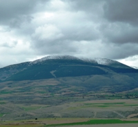
The Moncayo
The Moncayo massif and its surrounding mountains separate the Meseta from the Ebro Valley. It is located in the north-western corner of the Iberian Range, between the middle Ebro Valley and the highlands of Soria. Its highest peak, Moncayo, or Mons caunus as the mountain was called in Roman times (grey or white mountain), is also known as Pico San Miguel. At 2,315 m, it is the ceiling of the Iberian System.
The Moncayo is a first-order hydrologic watershed between the Douro and Ebro basins. It contributes significantly to the headwaters of three rivers -Queiles, Huecha and Isuela-, and to various other springs and fountains that supply water to villages and fields, located in the mid- and low-level areas.
Its location, on the border between the wet European and dry Mediterranean environment, allows it to intercept clouds from the Atlantic Ocean. This, together with its isolated location and peculiar geology, make this nature area a place of high biological diversity and ecological importance.
Holm oaks (Quercus ilex L. subsp. rotundifolia) grow at the foot of the mountain. Deciduous species, such as the Pyrenean oak (Quercus pyrenaica), thrive at higher altitude. Between 900 and 1,800 metres, the slopes are covered by dense reforestation pine forests of different species such as Scots pine (Pinus sylvestris), mountain pine (Pinus uncinata) or black pine (Pinus nigra). On the summits and cirgues, small plants like Chinese juniper (Juniperus chinensis), Savins juniper (Juniperus sabina) and broom (Cytisus multiflorus) can be found.
Moncayo's beech groves, distributed between 1,100 and 1,650 m, are one of the most southerly in Europe, which only enhances its ecological value. However, what makes this mountain unique is not only its biodiversity, but also the remains of three glaciers in San Miguel, San Gaudioso and Cucharón cirques, located in the northeast side of the massif’s summit.
The variety of environments found in the Moncayo contributes also to its rich and varied fauna. The common lark (Alauda arvensis), northern wheatear (Oenanthe oenanthe), water pipit (Anthus spinoletta) or the common stonechat (Saxicola torquata) can be found in the highlands. The shrublands are dominated by linnets (Carduelis cannabina), buntings (Emberiza cia) and robins (Erithacus rubecula). The latter, along with jays (Garrulus glandarius) are the most common birds in wooded areas. Flying at a higher altitude are abundant griffon vultures (Gyps fulvus) and a few Egyptian vultures (Neophron percnopterus), common kestrels (Falco tinnunculus) or golden eagles (Aquila chrysaetos), while goshawks (Accipiter gentilis) or sparrow hawks (Accipiter nisus) can be seen in the forests.
Frogs (Rana perezi), toads (Bufo bufo) and midwife toads (Alytes obstetricans) are common in the wet areas. There are also marbled newts (Triturus marmoratus) and webbed newts (Triturus helveticus), blindworms (Anguis fragilis) and water snakes (Natrix maura). Prominent among mammals are the wild boar (Sus scrofa) roe deer (Capreolus capreolus), fox (Vulpes vulpes), stone marten (Martes foina), genet (Genetta genetta), wild cat (Felis sylvestris), hedgehog (Erinaceus europaeus) and several species of mice (Mus musculus), shrews (Crocidura russula) and voles (Talpa europaea).
This diversity of wildlife species has made Moncayo a natural space of enormous ecological value. This has resulted in the designation of the massif as a protected area under various categories. In the past, the Administration had already recognised the need to protect the Moncayo. In 1927, the 1,500 ha "Dehesa del Moncayo" mountain was designated a Natural Site of National Interest. Later, in 1998, the Aragonese part was designated Dehesa del Moncayo Nature Park, covering a total of 9,848 ha.
Another 5,705 ha of the Moncayo massif are a Site of Community Importance (SCI) and 7,098 ha have been designated a Special Protection Area for Birds (SPA) within the European Natura 2000 network. The Agua Soriano-Camino Antonino Nature Trail runs along the boundaries these two areas when it traverses through the province of Soria.
Multimedia


Downloads
GPS Downloads
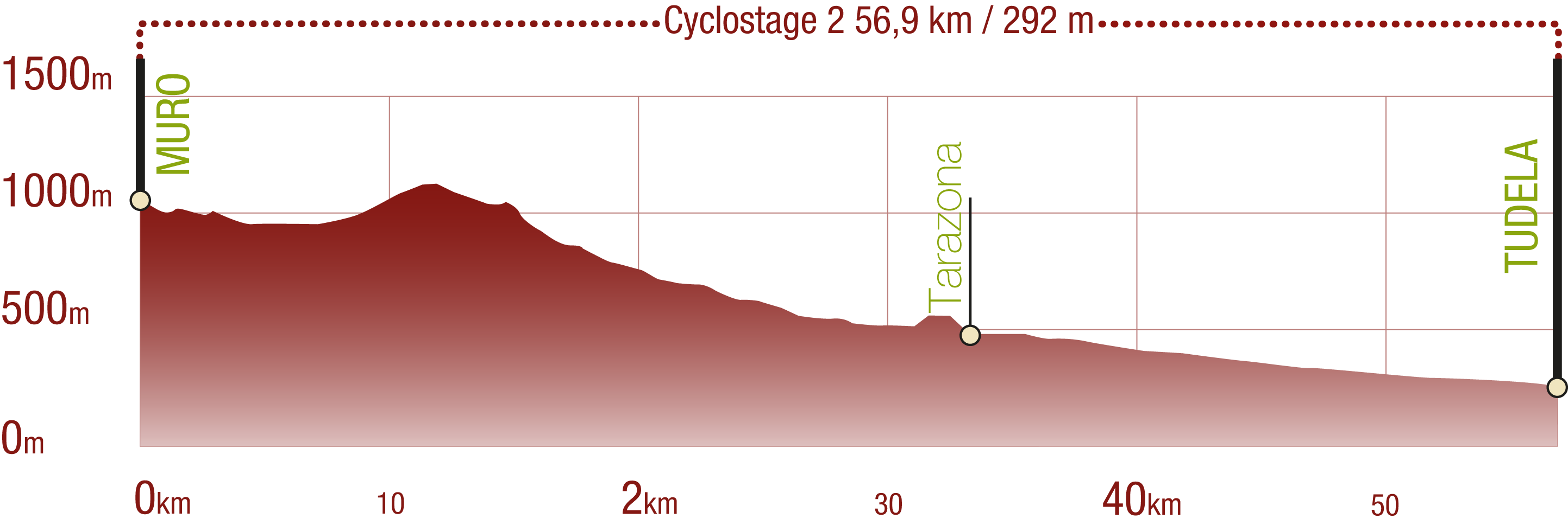
Cyclability
This Cyclostage corresponds to stages 4 to 6 of the Nature Trail
PROFILE
TYPE OF ROAD, PORTAGES & DIFFICULTY
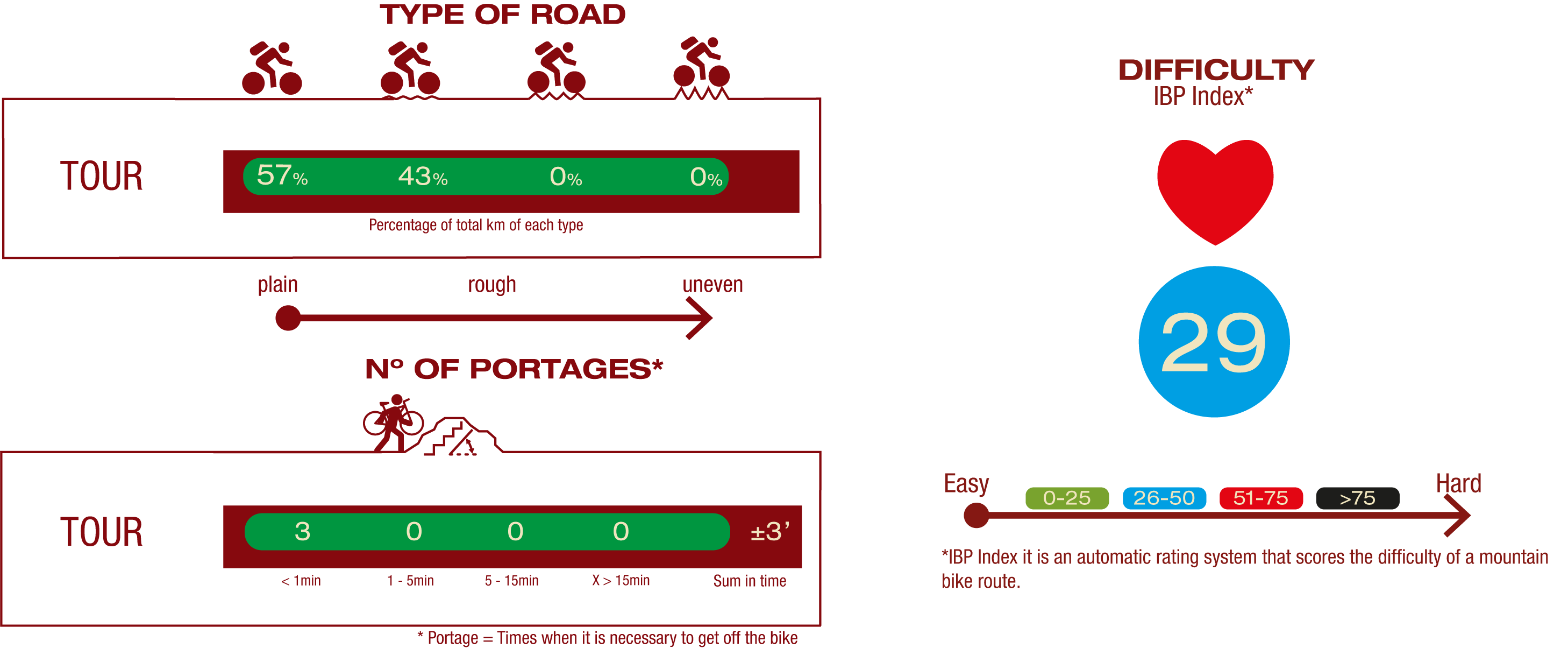
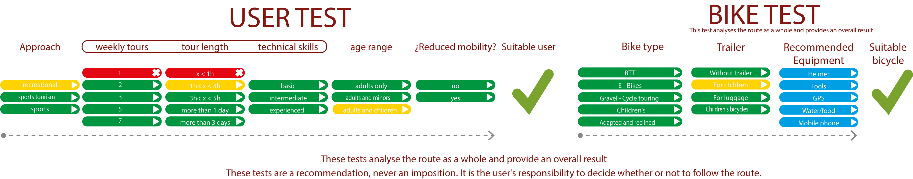
TEST
SAFETY RECOMMENDATIONS
- Sections shared with hikers and agricultural vehicles.
- Transit through the centre of some population centres.
GENERAL RECOMMENDATIONS
- Find out about the technical aspects of the route and the weather on the day.
- Take care of the environment. Take care not to disturb animals or damage vegetation. Respect private areas.
- You must give priority to pedestrians and comply with general traffic rules.
- The environment in which you will be riding is open, free to move around and an area where many activities are carried out (sporting, forestry, livestock and agricultural activities). Always have an understanding, prudent, responsible and respectful attitude.