La Palma Nature Trail
Description
By “Benahoaritas” Lands
Traditionally, the most important villages on the island of La Palma have been connected by the so called Camino Real de La Costa y Medianías (Royal Road of the Coast and Middle Lands). GR 130 is a trail based on these ancient paths which linked the villages of the region, and it is currently used for distances covered in half a day.
- - - - - - - -
IMPORTANT WARNING: DUE TO THE VOLCANIC ERUPTION THAT BEGUN IN 19/09/2021 IN CUMBRE VIEJA, THIS ITINERARY IS NOT PASSABLE IN SOME OF ITS SECTIONS!
- - - - - - - -
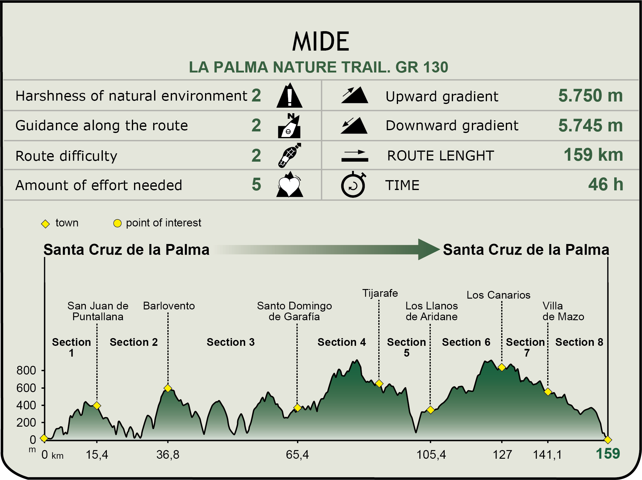
The 159 km of this Nature Trail, divided in eight sections, go around the island, circularly, starting in Santa Cruz de la Palma and continuing in a counter-clockwise direction.
GR 130: Camino Real de La Costa y Medianías (Royal Road of the Coast and Middle Lands).
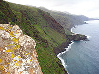
Santa Cruz de la Palma - San Juan de Puntallana
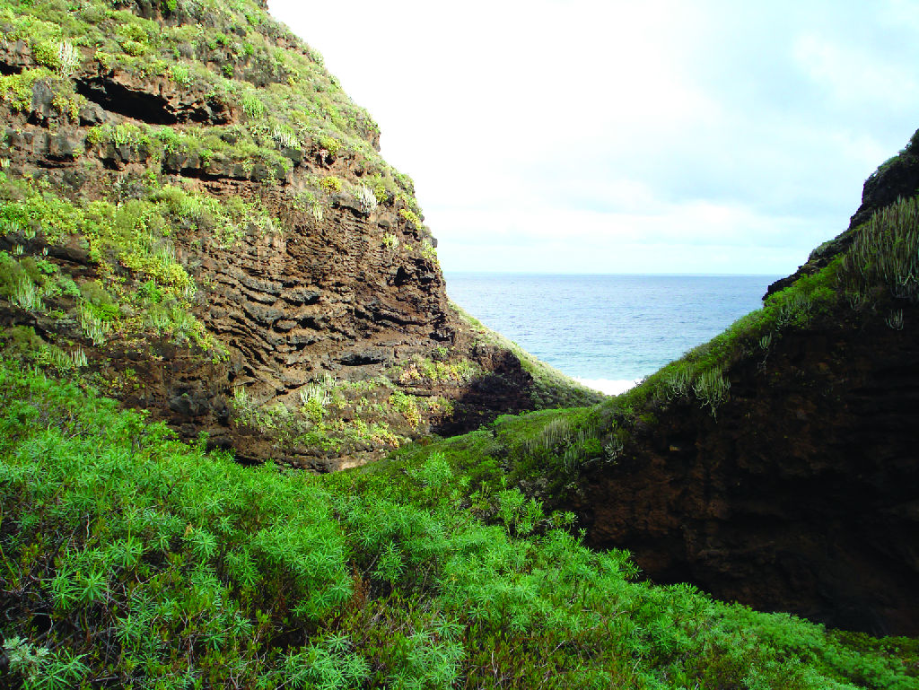
It runs between the municipalities of Santa Cruz de La Palma and Puntallana, a highly developed urban area. A hike along this section of the trail allows hikers to enjoy the historic quarter of Santa Cruz, see the 335 meter-deep Barranco de Agua, which has been named a site of special scientific interest and has one of the most important cardonal (teasel) fields on the island, and visit the shrine of Santa Lucia.
San Juan de Puntallana - Barlovento
From Puntallana to Barlovento travelers go through some of the most fertile and more efficient farmlands on the island. This part of the trail has an accumulated gradient of the slope of 1,100 m because of the five deep ravines crossing the region.
The ravines of this area have given rise to many legends, such as that of the “Jump of the Lover”, according to which a young man lost his life trying to impress and court his girl by doing a balance act, hanging over the ravine edge.
The historic center of San Andrés and Barranco de Nogales are-must see landmarks of this trail.
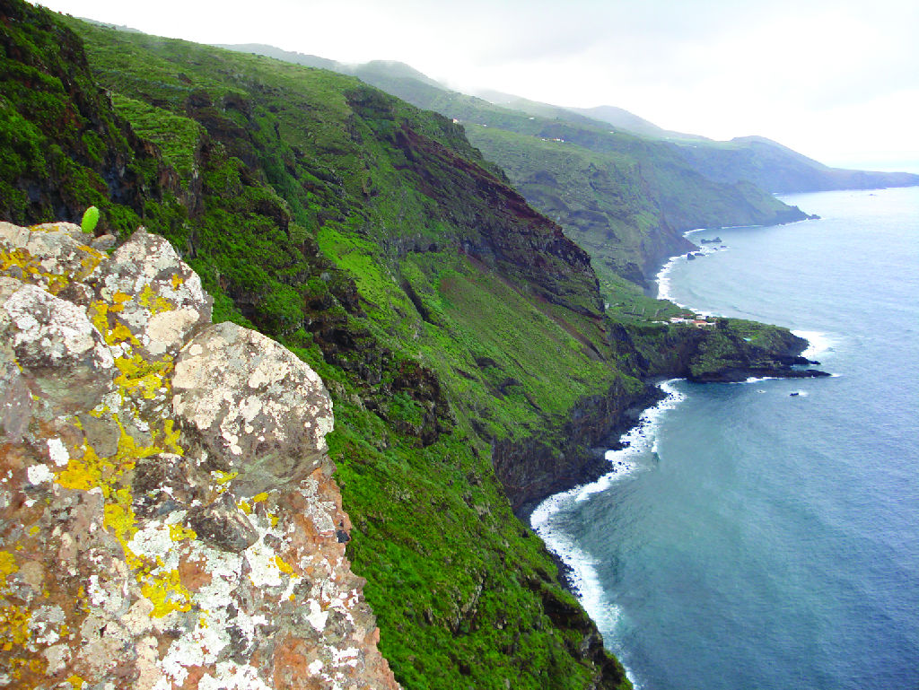
Barlovento - Santo Domingo de Garafía
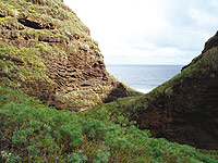
This section of the trail runs through the north of the island, where the lands are more isolated and the ravines are deeper. In winter, you will be faced with cold weather and the action of the trade winds. The laurel forest goes down to sea level, and the sea is rough in this part of the island. Part of these ravines and cliffs form the Special Nature Reserve of Guelguén.
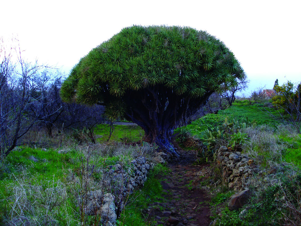
In addition to this Reserve, among the highlights of this part of the trail are the barrio or borough of Tosca, whose inhabitants made a living selling leaves of the plentiful Drago tree, which were used to weave baskets; also noteworthy are the stunning views from the viewpoint, once past Franceses, as well as a group of cave houses which were inhabited until the middle of the twentieth century.
You will find a smoother landscape and warmer weather during the last eight kilometers of the trail.
Santo Domingo de Garafía – Puntagorda - Tijarafe
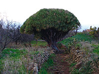
This stretch of the trail offers a continued but very amenable ascent through a beautiful rural landscape among the rugged slopes of ravines, with highlights such as the dragonales (Drago tree forests) of Buracas and the coquettish houses of Las Tricias.
From Buracas hikers can follow a 20 minute detour off the trail that will allow them to see some of the oldest and most impressive specimens of Drago trees (Dracaena draco). After seeing the shrine of Sagrado Corazón de Jesús de Tinizara, very close to Puntagorda, hikers should visit El Fayal, a stronghold of forests with centenary pine trees (Pinus canariensis), and an undergrowth of tree heaths (Erica arborea) as well as patches of fayas of fire trees (Myrica faya) after which the place is named.
Tijarafe - Los Llanos de Aridane
This is one of the shortest trails of the GR, concealing wide landscapes like those going through the Aridane valley, and ending up in a final stretch that reaches one of the largest urban areas on the island.
This part of the trail also boasts the impressive cliffs at Laderas de Amagar, crossed by a path named Vueltas de Amagar (Rounds of Amagar) because of its 73 bends or curves leading down to the protected landscape of Barranco de las Angustias. Before reaching the bottom of the cliff, hikers will see the Virgen de las Angustias shrine.
Close to this path, travelers can also see the natural monument Los Volcanes de Aridane (Aridane Volcanoes) consisting of the volcanic cones of Argual, Triana, La Laguna and Todoque, which are situated parallel to the coastline of the Aridane Valley.
Los Llanos de Aridane - Fuencaliente
This stretch of the trail has two very distinct sectors. The first one is a populated area, while the second is overlooked by the lava fields of the protected landscape of Tamanca and the pine groves of Fuencaliente.
You can see the image of the Virgin of Fatima in its niche; in 1949 the progress of the lava flow towards the neighborhood of San Nicolas was stopped in this place just in time to save it from destruction.
The last leg of this trail reaches the southern cone of the island. Hikers can see the coastline to the east and to the west, and the island of El Hierro just in front. Along the way, the path skirts ancient calderas which are now almost level with the ground surface.

Los Canarios - Villa de Mazo
In this part of the trail the landscape is transformed from crop lands and lone pine groves in the higher lands of Fuencaliente to more developed urban areas such as Villa de Mazo. In Tigalate and Tiguerorte, the trade winds are always present, dry and fast for having already crossed the whole island.
As it progresses toward the south, the trail turns east and makes it possible for us to get a glimpse of the islands of Tenerife and La Gomera in the distance. Highlights of this section of the trail are the fountain of Los Roques and the pebble road in the borough of Montes de Luna in Villa de Mazo.
Villa de Mazo - Santa Cruz de La Palma
This last stretch of the trail takes us through one of the most urbanized areas of the island. The numerous crosses travelers will see along the way, particularly on its last leg, are a manifestation of the religious zeal of the population as expressed by the traditional Cruces de mayo (May Crosses).
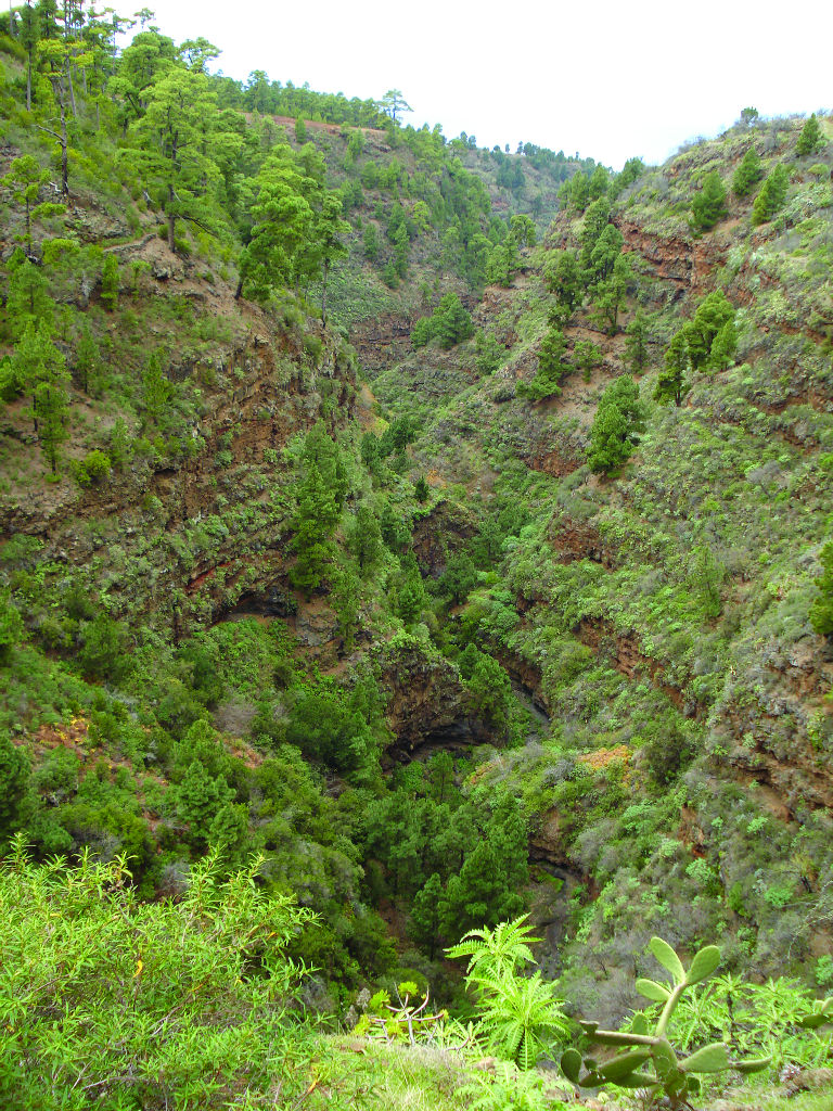
This entire section of the trail goes through back roads that lead to the site of scientific interest Juan Mayor. This protected area includes the ravines of Pájaros and Juan Mayor, particularly noteworthy for their thermophile forests, increasingly rare in this part of the island.
Very close to the trail is the Natural Monument Risco de la Concepción, a spectacular volcanic complex that offers magnificent views.
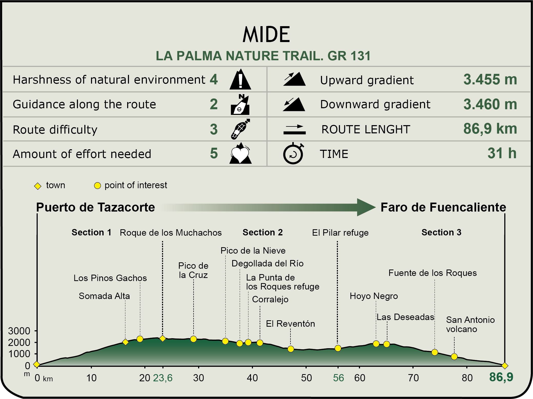
GR 131 "El Bastón"
This trail, known colloquially as “El Bastón” ("The Cane"), has its origin in the union of two paths: the Ruta de los Volcanes or Volcano Trail, between the shelter of El Pilar and Fuencaliente, and the Ruta de la Crestería or Crestería Trail, which runs along mountain crests in the national park Caldera de Taburiente. The extension of both tracks into the sea creates GR 131, so named because it is in the shape of a cane, and runs along the rest of the Canary Islands crosswise.
Puerto de Tazacorte - Roque de los Muchachos
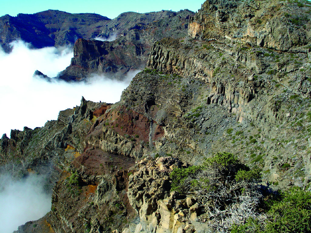
This first section of the trail is a hard ascent from sea level to the highest point of the island, 2,426 m, in the National Park of Caldera de Taburiente. Along the climb, we reach in succession the Time viewpoint and the Hoya Grande viewpoint, from where we can see the Aridante Valley and Caldera respectively.
Further on, we reach the degollada superior (higher pass), 1,344 m, which boasts unsurpassed views of Aridante Valley, Llanos de Aridante and Lomo de los Caballos. At this altitude, the crop lands disappear completely, replaced by pine groves.
Once past the crag of Las Pareditas and of Somada Alta, we reach Los Pinos Gachos (Hunched Pines), one of the most spectacular places of the whole trail. Its name makes reference to the tortuous shape of the pines, caused by the fires that have plagued this area. From this place visitors can see the full extent of the Caldera.
On the hilltops, the pine trees give way to shrubs consisting of retamón (Genista benehoavensis) and codeso or laburnum (Adenocarpus viscosus), as a prelude to the vegetation prevailing in Roque de los Muchachos, where this stretch of the trail ends.
Roque de los Muchachos - Refugio de El Pilar
The second stretch of the trail can be divided into three different legs. The first leg runs along the entire edge of Caldera de Taburiente, from Roque de los Muchachos to the shelter at Punta de los Roques, avoiding the higher areas and staying at all times at an altitude of over 2,000 m, through shrubbery and pine trees.
The second leg descends rapidly from the shelter at Punta de los Roques to the track at La Hilera, from where it is possible to make out, in the distance, Santa Cruz de La Palma to the east and the Aridane Valley to the west.
The third and last leg of this section of the trail reaches the shelter at El Pilar, and showcases the great diversity of landforms in the area, and the transition toward crop lands.
Refugio de El Pilar - Faro de Fuencaliente
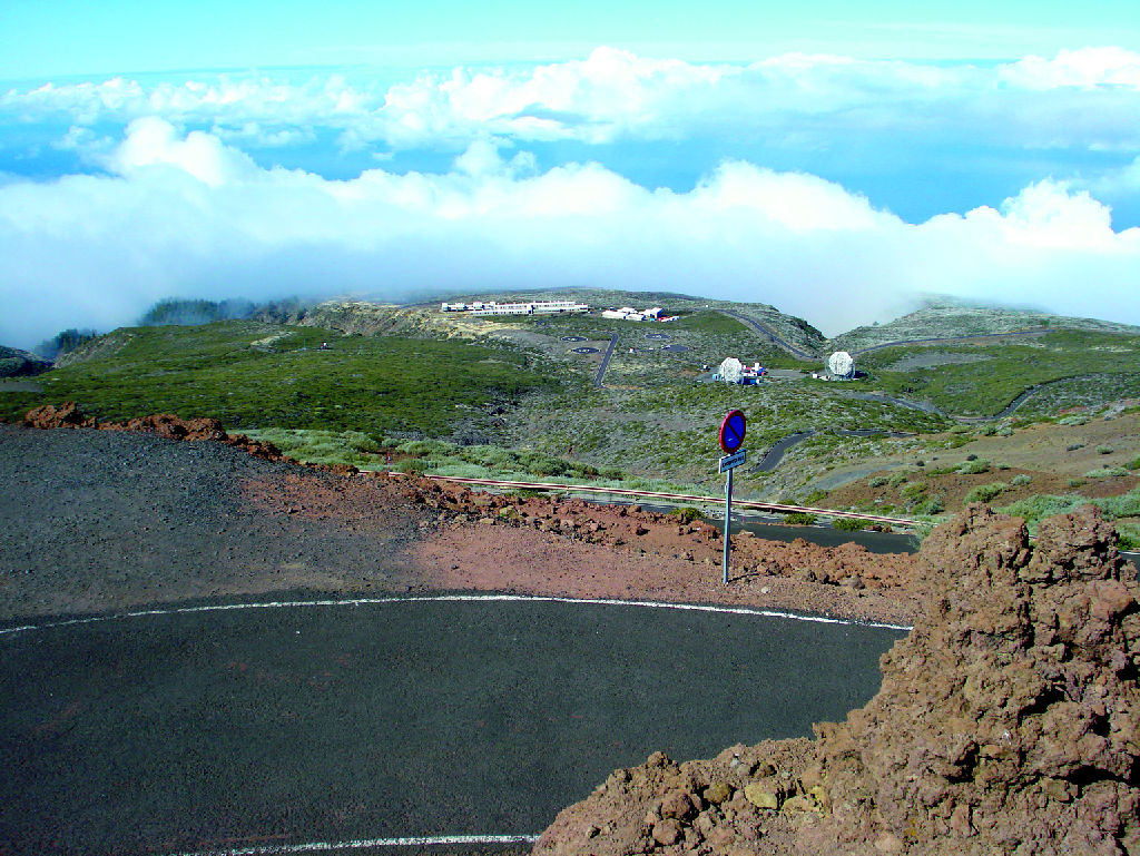
The third section of the trail takes us through the Volcano track, which runs along the higher areas of the natural park of Cumbre Vieja.
Starting at the shelter and heading in a southerly direction, the trail goes through some of the most spectacular volcanic craters in the Park, such as Hoyo Negro, Duraznero, Cabrito or Montaña de Fuego.
Pines begin to take over in the vicinity of the recreational area of Fuente de los Roques, anteroom to Fuencaliente, where the track skirts the San Antonio volcano and reaches the lighthouse at Fuencaliente, where the trail comes to its end.
Once we have reached this point, the beach and the salt marshes - named a site of scientific interest - are well worth visiting.
The trails La Palma GR 130 and GR 131 are described in detail in the topographical guide to the island of La Palma entitled "Red de senderos de La Palma" (“Network of La Palma Tracks”) published by the Cabildo Insular de La Palma.
Profile
GR-130: Camino Real de la Costa y Medianías
GR-131 "El Bastón"
MIDE (Method for the Information of Excursions)
 Harshness of natural environment
- 1. The environment is not risk-free
- 2. There are more than one risk factors
- 3. There are various risk factors
- 4. There are quite a lot of risk factors
- 5. There are many risk factors
 Guidance along the route
- 1. Well defined trails and crossings
- 2. There is a clearly marked trail and signage
- 3. Requires the identification of geographic features and cardinal points
- 4. Requires off-path navigation
- 5. The trail is interrupted by obstacles that have to be gone around
 Route difficulty
- 1. Walking on a flat surface
- 2. Trails with different types of path
- 3. Walking on stepped paths or irregular terrain
- 4. The use of hands or jumping over the terrain is necessary
- 5. The use of hands is required to progress
 Amount of effort needed
- 1. Up to 1 hour of continuous walking
- 2. Between 1 and 3 hours of continuous walking
- 3. Between 3 and 6 hours of continuous walking
- 4. Between 6 and 10 hours of actual walking
- 5. More than 10 hours of continuous walking
Featured
Further information
Island of La Palma
La Palma is one of the seven islands that form the Canary archipelago. It is known as "Isla Bonita" (the beautiful island) both for its spectacular natural landscape, of which laurel and Canary pine forests are a highlight, and for its old colonial style villages and towns.
The early inhabitants of the La Palma called their island “Benahoare" (“My land”), and divided it into 12 cantons or dominions, each of which was ruled by a lord or “mencey”. The aboriginal population lived mostly off grazing (goats, sheep and pigs). Currently, livestock farming is a marginal activity and tourism has become the main economic engine of the island.
The island of La Palma was named a Biosphere Reserve in 2002, since it has two Natural Parks, as well as the National Park Caldera de Taburiente. These natural areas have been exceptionally well preserved thanks to the implementation of an economic model that combines sustainable tourism and traditional agriculture.
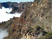
National Park of La Caldera de Taburiente
Caldera de Taburiente, with an area of 4,690 ha, was named a National Park on October 6, 1954. It is formed by a huge caldera-shaped cirque with a diameter of 8 km created by volcanic eruptions, massive landslides and the erosive action of wind and, specially, water.
The Caldera has elevation changes of up to 2,000 m, as well as an important network of brooks and streams that remains practically unspoiled thanks to the good preservation of the vegetation cover.
Among the many plant species this area is home to, the most important ones can be found in laurel forests: Canary Island fire tree (Myrica faya), tree heath (Erica arborea), and Canary Island pine (Pinus canariensis), main plant formation in the Park, and remarkable for its adaptation to fires.
Multimedia