
- Home
- Rural Development
- Nature Trails
- Nature Trails
- Canary Islands Sector
- Fuerteventura
Stage 5: Betancuria - Pájara
Description
La Vega de Río Palmas and Virgen de la Peña
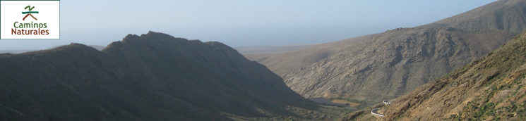
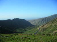
After a stroll through the narrow streets of Betancuria, the Nature Trail continues southward along Morrete de Tegetuno through a repopulated pine grove area that offers a stark contrast to the vegetation along the path, as well as through traditional farmlands in the region of Vega de Río Palmas and the Los Granadillos Valley, finally reaching the village of Toto and heading out to Pájara, where this section of the trail comes to its end.
The path begins in Betancuria, where the Nature Trail invites us to explore the historic quarter of this beautiful town, named a Historic and Artistic Monument. Built inland, on a valley protected from the attacks of pirates, its situation did not prevent, however, the village to be reduced to ashes in 1593 by the hordes of Xaban de Arráez, after having been previously attacked on several occasions throughout the sixteenth century.
Betancuria is the smallest municipality of Fuerteventura, and it was the capital of the island from the sixteenth until the mid-nineteenth century, when Puerto de Rosario became capital city. Its status as capital city of the island for such a long time makes it possible to find places of great interest, such as the cathedral of Santa María, a mix of different styles, from Gothic to Baroque, with Renaissance and Mudejar elements, since building the cathedral took a hundred years.
Before leaving the town center, we can also enjoy a visit to several museums, such as the Museo de Arte Sacro (Sacred Art Museum), the Museo Arqueológico (Archeological Museum) and the Centro Insular de Artesanía (Insular Craft Centre) dedicated to traditional crafts. The road will also take us to the waterwheel at Pozo de los Peña, formerly used to obtain and raise well water. From this point, and after a short stretch of asphalt road, we begin to ascend along a dirt path that will take us to Morrete de Tegetuno, a route that offers excellent views of the town of Betancuria, as well as a variety of plants that, even though some of them are not native to the island and have been introduced in later times, liven up the landscape with a touch of color.
Of particular note among the various plant species that we can see are pitas or piteras (Agave americana), native to America, almonds (Prunus dulcis) and two typically Mediterranean species such as the Aleppo pine (Pinus halepensis) and the carob (Ceratonia siliqua).
Once we have reached Morrete of Tegetuno – where we find a stone resting area with tables and benches - we will head out in a southerly direction along a path that offers great views of the villages of Antigua and Betancuria. At Degollada de Tegetuno we can choose to go ahead in an easterly direction up a hill that leads directly to the village of Antigua along a local path (SL FV 29) with a gentle slope.
After walking a little over a kilometer, we must head south without making any mistake, because at this point we enter an area of reforested pines which is the only hill listed as a public interest site on the island: Castillo de Lara, where the pines that grow in the more sheltered valleys reach up to 10 m. Within this pine grove there is a recreational area with fireplaces, swings and tables.
After that, the trail continues along a path marked by stones which leads to the area known as Los Charcos, on top of Cerro de Betancuria, from where we begin to glimpse a valley where lies the charming little village of Vega de Río Palmas, named this way (Palmas River Meadow) by the conquerors of the island due to the great number of palm trees and water springs on this meadow, starting point of several local trails (SL FV 27, 28 y 31), which are very well worth exploring.
On the descent from Cerro de Betancuria into the valley we will find Casa de los Padrones, and old building that has been refurbished and adapted to be used as a shelter; from that point, we begin to descend, paying attention to the vertical directional signs, since the trail leaves the dirt track we have used so far and heads down to a riverbed along the ravine of Palomares, from which we will follow a path until we reach the village of Vega de Río Palmas.
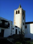
Even though the path does not go through this village, it is advisable to make a slight detour in order to visit the shrine containing the image of the Virgin of the Rocks, patron of the island, which is an eighteenth century building with a sober façade in neoclassical style. The shrine houses the image of Our Lady of the Rocks, carved in alabaster, which was brought by the conquerors when they occupied the island. This sculpture is one of the most iconic symbols of Fuerteventura, and every third Friday in September, many “Majoreros” (inhabitants of Fuerteventura) gather in the shrine to worship in front of the image.
Along the stretch of the trail that is paved, we find a detour that coincides with the local trail SL FV 27, heading towards the dam at Las Peñitas. We will continue, without leaving the road, until we find a dirt track going up to Degollada de Los Granadillos, past an American windmill used for the extraction of well water, and going through abandoned farming terraces.
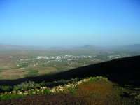
In Degollada de Los Granadillos we can enjoy the views from a resting area before we descend into the valley, going through many crop lands, where we see the traditional gavias or ditches, until we reach Toto, a small village located in the bottom of the valley, where the shrine of Degollada de Los Granadillos, declared an asset of cultural interest in 2008, is a landmark.
Once past the village of Toto, we leave for Pájara, along the Pájara y Toto ravine, until we come to the square in front of the church of Nuestra Señora de Regla in Pájara (seventeenth and eighteenth centuries), which has also been named an asset of cultural interest. In this square, where the City Hall of Pájara stands, we finish this section of the trail. The town of Pájara, founded in the fifteenth century, gained importance owing to the slave trade, activity which was the origin of a prosperous past that is reflected in the stone houses of the town center.
Sites of interest
Profile
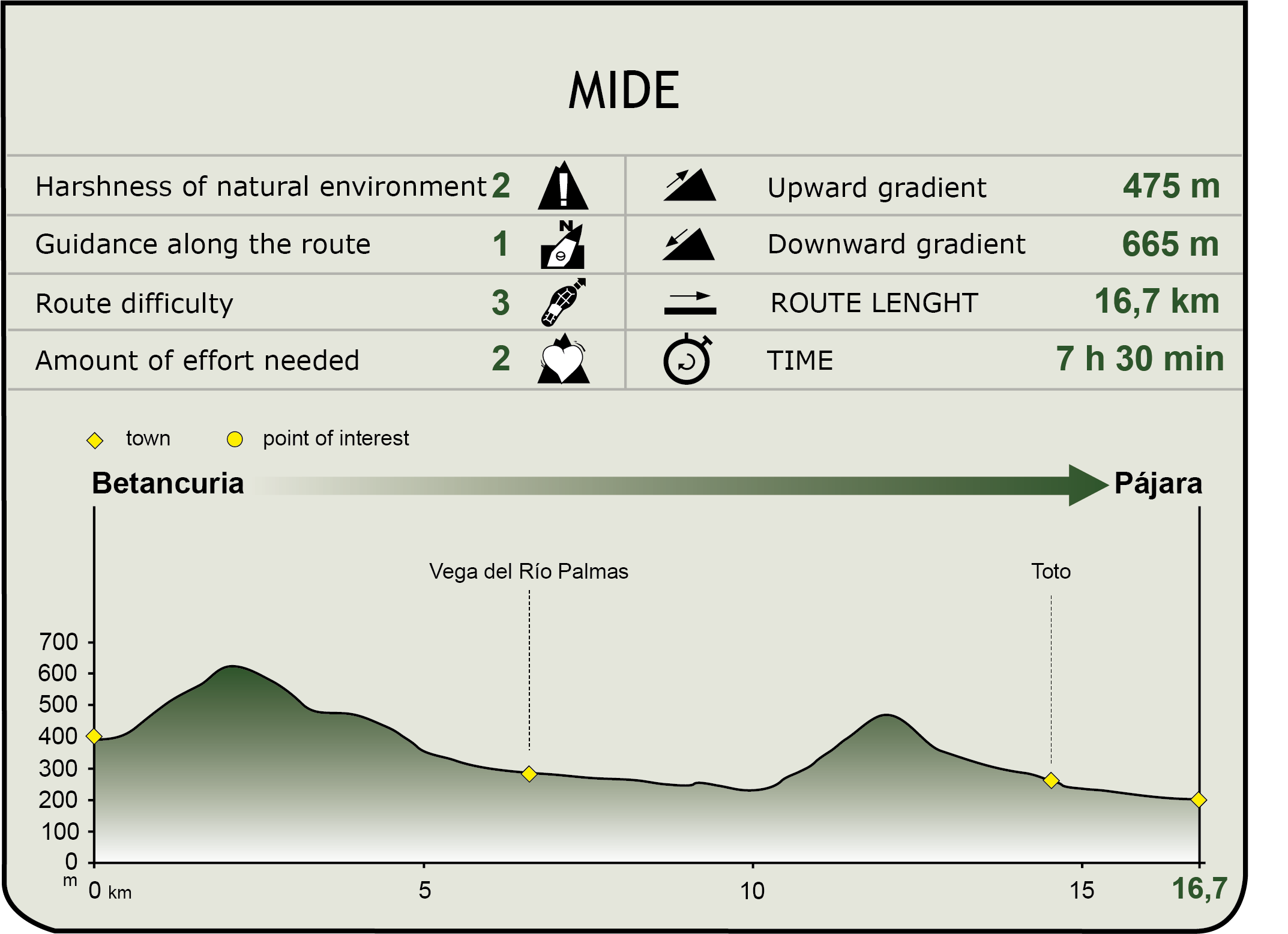
MIDE (Method for the Information of Excursions)
 Harshness of natural environment
- 1. The environment is not risk-free
- 2. There are more than one risk factors
- 3. There are various risk factors
- 4. There are quite a lot of risk factors
- 5. There are many risk factors
 Guidance along the route
- 1. Well defined trails and crossings
- 2. There is a clearly marked trail and signage
- 3. Requires the identification of geographic features and cardinal points
- 4. Requires off-path navigation
- 5. The trail is interrupted by obstacles that have to be gone around
 Route difficulty
- 1. Walking on a flat surface
- 2. Trails with different types of path
- 3. Walking on stepped paths or irregular terrain
- 4. The use of hands or jumping over the terrain is necessary
- 5. The use of hands is required to progress
 Amount of effort needed
- 1. Up to 1 hour of continuous walking
- 2. Between 1 and 3 hours of continuous walking
- 3. Between 3 and 6 hours of continuous walking
- 4. Between 6 and 10 hours of actual walking
- 5. More than 10 hours of continuous walking
Featured
Further information
Fauna and flora
On the road between Toto and Pájara we can see specimens of Canary Island date palm (Phoenix canariensis) and ice plant or “barilla” (Mesembryanthemum crystallinum). Once past Toto, we can see interesting specimens of balsam spurge (Euphorbia regis-jubae and Euphorbia balsamifera), as well as other species, such as aulaga (Launaea arborescens), southern teaplant (Lycium intricatum) and verol or Canary Island candle plant (Kleinia neriifoiia).
In this part of the trail we can also see Canary Island daisies or jorjados (Asteriscus sericeus), a species endemic to Fuerteventura which grows on the slopes of the higher hills, and cuernúa (Caralluma burchardii), a small cactus-like plant, also endemic to the island, which grows between rocks in some slopes of the Betancuris massif. In addition to the endemic species, there are some plants introduced from abroad that have become wild, such as the agave (Agave americana), the prickly pear cactus or tunera (Opuntia spp.) and the tree tobaco (Nicotiana glauca).
The fauna in this area is somewhat different from that of the rest of the island in terms of biodiversity and abundance, due to its specific topographical, climate, and botanical characteristics and, above all, to the presence of water. Highlights include native species such as the clear edge bat or Kuhls pipistrelle (Pipistrellus kuhlii), rare and localized around the dam of Peñitas, as well as the Canary Island shrew (Crocidura canariensis), a small mammal of nocturnal habits endemic to the region. Barbary ground squirrels (Atiantoxerus getuius) are quite abundant in the region, and were introduced into the island in 1965. Among birds, we should mention the Fuerteventura stonechat (Saxicola dacotidae), exclusive to the island, and the guirre or Egyptian vulture (Neophron percnopterus majorensis), the only species of vulture that lives on the island.
Multimedia


