- Home
- Rural Development
- Nature Trails
- Nature Trails
- Canary Islands Sector
- Costas_Gomera
Stage 3: Playa de Vallehermoso - Alojera
Description
An ancient and rugged landscape
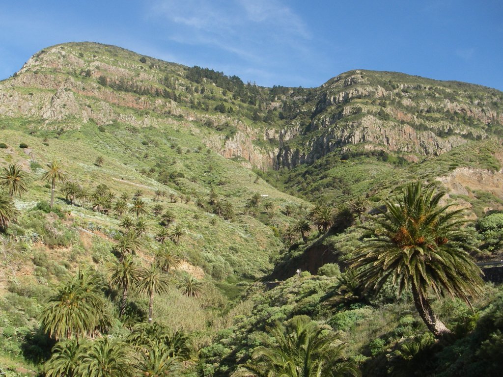
Along the 15.5 km of this Stage of the trail, connecting the Marine Park of Playa de Vallehermoso (Vallehermoso Beach) with Alojera, we will pass through the most ancient geological materials of the island, the so called basal complex. The erosion of these old materials has created some incredible scenery, which, along with the spectacular views of the north coast of the island, makes this Stage of the trail a veritable feast for the senses.

This trail Stage begins at the Marine Park of Vallehermoso Beach, exactly at the spot where the nature trail Cumbres de La Gomera, coming from Vallehermoso, ends. During the first 300 m, we must be careful with the presence of road traffic, since we will have to walk along the road until we reach a small group of houses, located at kilometer 3, where the route branches off to the right along a stretch of concrete steps in order to ascend to Chijeré and the shrine of Santa Clara.
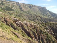
From this spot, we will face a tough stretch of zigzag ascent up one of the steepest slopes of the ravine of Vallehermoso. It is a challenging ascent in terms of physical effort and attention because of the steep gradient of some parts of the path and the unevenness of the terrain, which requires a certain level of endurance from hikers. This effort is soon rewarded, since, as the path gets higher, we can enjoy spectacular views of the ravine of Vallehermoso, with its fertile valley floor and the distinctive profile of the volcanic plug Roque Cano, as well as the cliffs of the northern coast of La Gomera, shaped by the rough swell of the Atlantic Ocean, hammering this part of the island coastline.
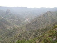
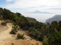
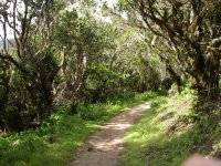
Along 1.7 km of steep ascent, the traveler goes through the most common plant community in this part of the island, the sabinar or juniper forest, this one being one of the largest of the island in spite of the fact that it has become less rich in species and is also noticeably less densely forested than it used to be. The Canary Islands juniper (Juniperus phoenicea var. canariensis), is the predominant species in the forest, although in areas closer to the coast we also find other species, such as the alcanutilla or leafless spurge (Euphorbia aphyla), tabaibas or Berthelot spurge(Euphorbia berthelotti) and matorrisco or Canary Island lavender(Lavandula canariensis). As the route gets higher, we can also see specimens of Canary Island pine (Pinus canariensis) and wild olive tree (Olea cerasiformis) alternating with junipers until the ascent ends in the region surrounding mount Alcalá. At this point the traveler should not miss the opportunity of taking a detour to the right, leading to the overlook in Punta de Alcalá (Alcalá Point), where he will enjoy a well-deserved break, sitting at the tables placed in this privileged location and reveling in the beautiful views of the Vallehermoso basin, mount Alcalá, and the majestic mount Teide – usually wrapped in a sea of clouds caused by moist air driven toward the slopes of the mountain by the trade winds - towering over the neighboring island of Tenerife.
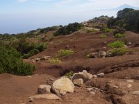
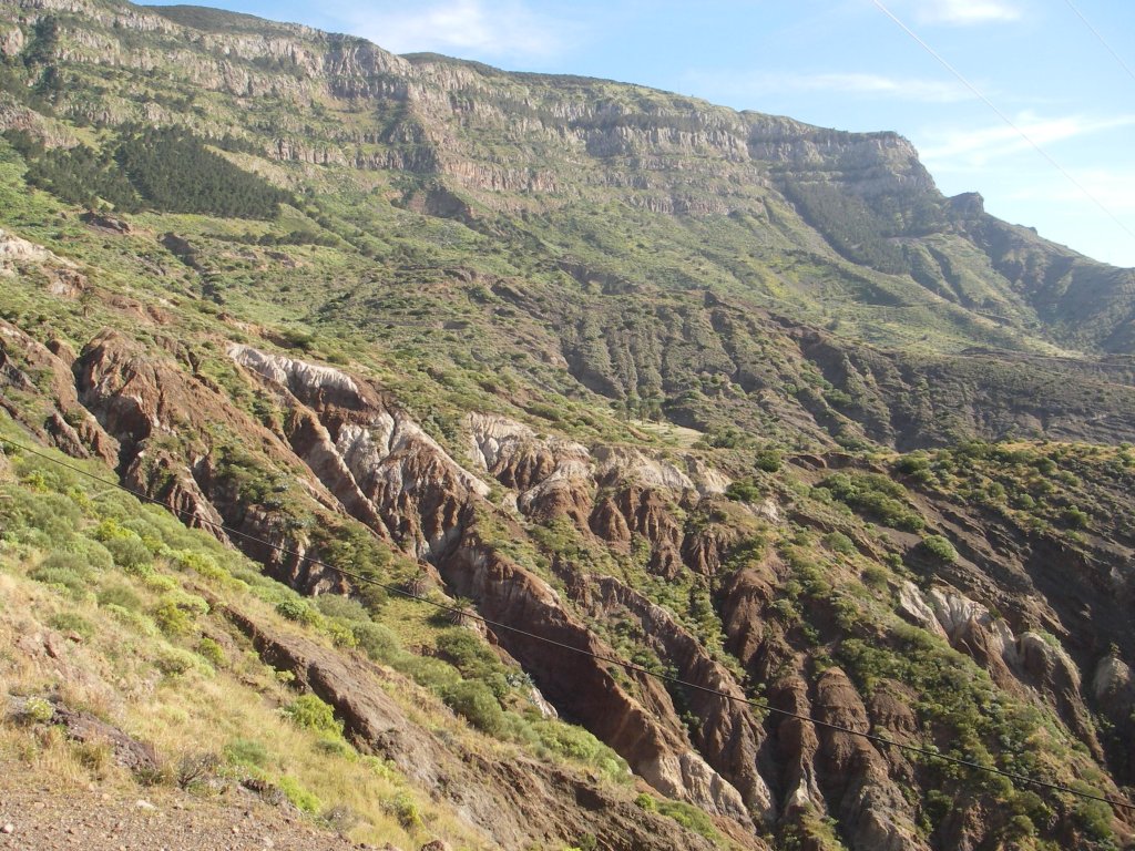
Having retraced our steps back to the trail, we now follow a comfortable path along the shady side of the hill where the gradient is much less steep and the eroded and ancient landscape is dotted with a beautiful juniper forest. After a little more than 500 m, we find a detour to Chijeré, a small settlement that was once very important as a livestock and farming center, as evidenced by the stone walls and terraces surrounding the village. It was used as a military watchtower during the Civil War owing to its strategic position, with commanding views of the neighboring islands of La Palma and El Hierro. Following the route, we see on the left of the path the pretty shrine of Coromoto, built in a beautiful and almost deserted area around mount Chijeré by a Venezuelan husband and wife in 1985. This part of the trail offers a scenery of unique beauty, originated in the severe erosion suffered by the materials of the basal complex that outcrop in the northern part of the island, with a very decomposed and altered rock layer and the presence of curious geological formations caused by very ancient eruptions: large stone boulders created by gas bubbles enclosed in the lava, volcanic bombs embedded in petrified ash, or striations of varied colors due to the mixing of different minerals.
We are now in the vicinity of Monumento Natural de los Órganos (Natural Monument Los Órganos) one of the most spectacular volcanic formations in the whole island, although only from the sea can we appreciate the full extent of this peculiar formation, created by the emission of a large mass of very viscous lava that cooled off very slowly and fractured at different levels, originating structures shaped like polygonal prisms, which have been laid bare by the erosion of the materials that covered them by the action of the strong ocean swell that hammers this part of the island.
This strongly eroded landscape accompanies us until we reach a detour to the right, properly marked, leading to Los Chorros de Epina, in an area locally knowns as Terreno de las Brujas (Land of the Witches), where there is a reservoir and a station to harvest horizontal water flows originating from dew and from mists and fog, which are quite common in this area. In this part of the trail, we can appreciate the contrast between the lush colors of the evergreen hills, in the higher part of the slopes, and this eroded terrain, where small dams and walls have been built to forestall the effects of erosion.
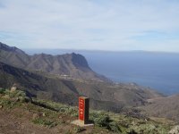
Taking a detour to the right, we can enjoy beautiful views of the northwestern coast of the island, with the neighboring island of La Palma in front of us and mount Teide still visible behind us.
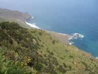
Gradually, the road enters an increasingly thick tree heath (Erica arborea) grove - with such species as granadillos or Canary Islands St. John's-wort (Hypericum canariense), magarzas or marguerite daisies (Argyranthemum frutescens)and ferns - and turns into a narrow path that is fenced by a wooden railing in some parts of the trail in order to protect hikers from the very steep gradients of the hillsides. On the right, perched on the steep slopes of the ravine of San Juan, we can see the rural village of Arguamul, which is only accessible on foot or by off-road vehicle and has a rugged and beautiful coastline with a large number of cliffs, roques and reefs, such as the roques or volcanic plugs in Aguamul beach, and the hill of Bejira, jutting out sharply into the rough waters of the Atlantic Ocean.
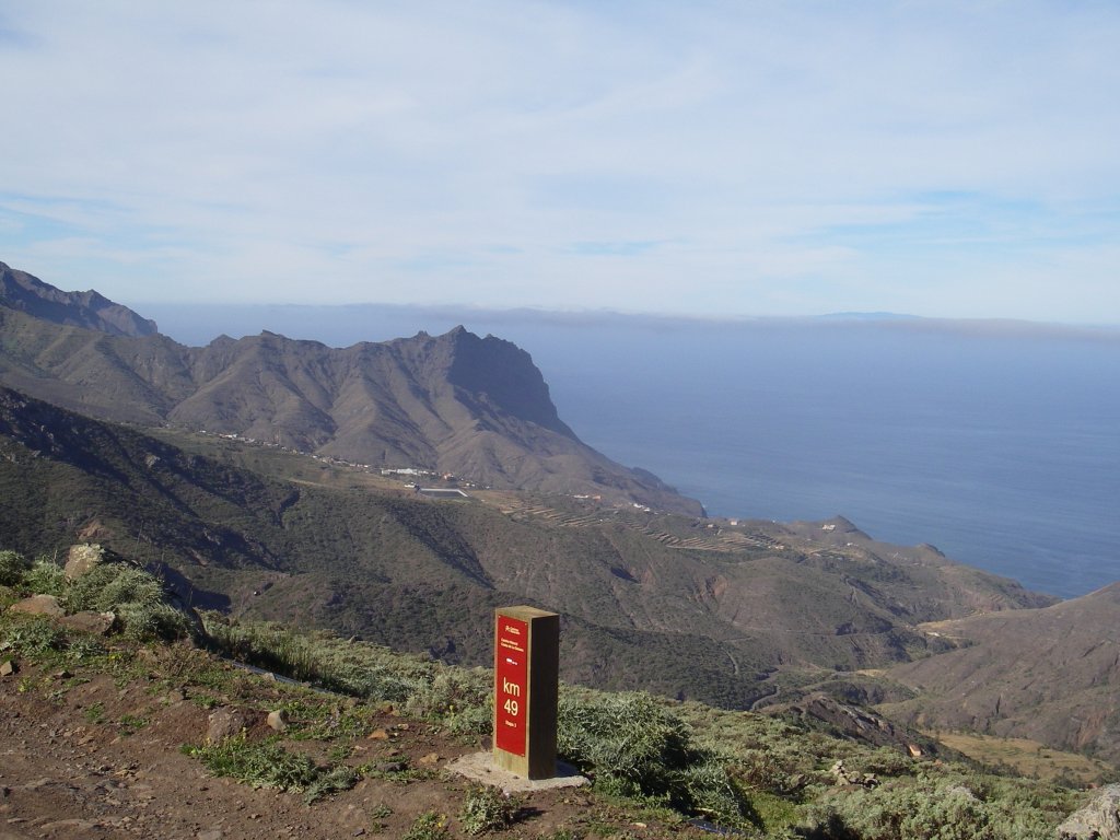
The trail continues under a dense canopy of fayal-brezal (fire-tree/heath grove) until reaching an area equipped with grills and tables near a terrace by the shrine of Santa Clara, where travelers can take a break and enjoy the spectacular views offered by the precipitous valley of Arguamul and the neighboring islands of La Palma and El Hierro, which on a clear day are visible in the horizon. After walking past a cross inscribed with words addressed to pilgrims, the path continues, skirting on its right side the basalt mountain of Teselinde; we then start a descent toward Epina, going through a typical Macaronesian formation of fire tree-heath characteristic of the island. Once we reach kilometer marker #48, the route continues under the slopes - carpeted with heather - of mount La Caldera, on the right side of which we can see the ravines of La Higuera and Bejira.
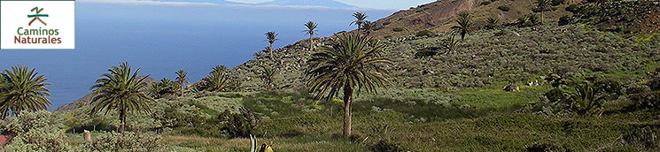
As we descend, the landscape changes gradually, and the wooded area starts to disappear almost completely, being replaced with typical Canary Islands scrubland mixed with isolated specimens of juniper and Canary Islands palms (Phoenix canariensis), which begin to appear in this transition area between monteverde or ever green terrain and coastal vegetation, thriving in the more humid lower levels.
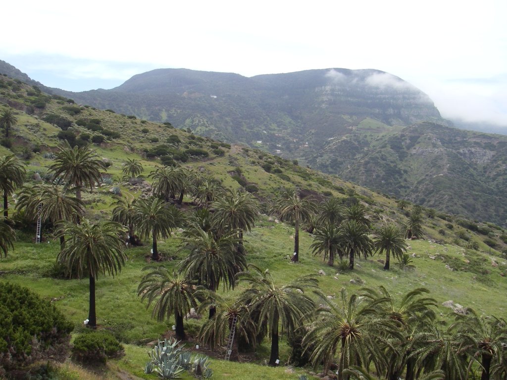
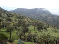
The trail passes by the foot of the mountain of Puntilla, and then it branches off to the right along a dirt track leading to the villages of Tazo and Arguamul, where we can see one of the richest communities of Canary Islands palms in the whole island, with more than twelve thousand trees, and where it is still possible to fully appreciate the importance for the past and present of this region of the traditional uses of palm trees (the extraction of the guarapo or palm syrup obtained from the sap of the palm, and the production of palm honey being but two of the most unique ones).
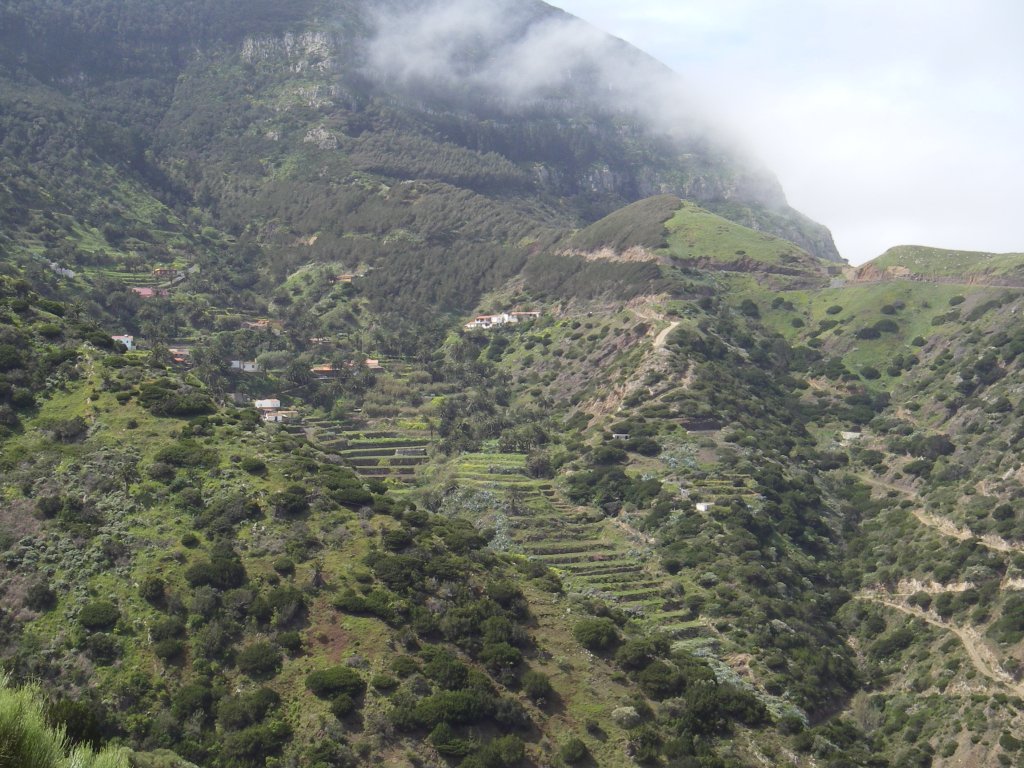
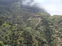
After walking 110 m along this dirt track, the route branches off to the left along a path that takes us smack in the middle of a palm grove known in the region as Cañada de Teheta (Teheta Glen). Some 300 m after the detour, we can see, under a large palm tree, the ruins of an old kiln that was used to manufacture the tiles that used to cover the traditional houses of nearby hamlets, made of mud bricks and stone. Some of these country houses are still standing and in good condition in places such as Cubaba, Tazo and the oldest quarter of Epina, in the area known as La Pila.
After passing by the Era de Teheta (Teheta Plot), which was an ancient meeting place of the Guanches, the path leaves the palm grove and continues its descent; on the left, we can see Alto del Llanito and, on the right, the island of La Palma, while, in front of us, we can see the village of Epina and its terraced hillsides under mount Zarza, as well as the end of the ridge of Carretón.
Once more the vegetation changes in this part of the trail, and is now characterized by the presence of heath and juniper, with some brooms and isolated palms. In areas where the trail crosses the bed of a small glen or ravine, there appears vegetation characteristic of more humid areas, such as brambles (Rubus sp), ferns or pitas (Agave americana). Along the next part of the trail, until we reach Epina, the path sometimes ascends (in some stretches we will find wooden steps to facilitate our ascent) and sometimes goes down, showing travelers a beautiful scenery of ravine bottoms canopied with palms and hillsides dotted with heath and juniper.
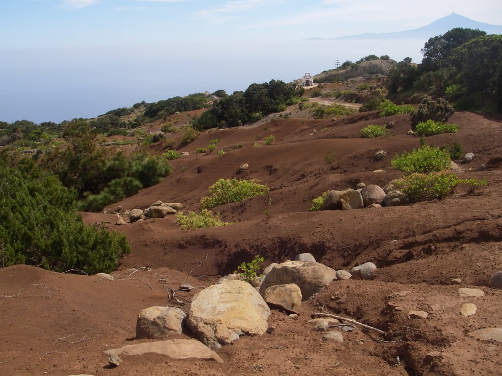
In the vicinity of Epina, surrounded by palms, pitas and prickly pears (Opuntia maxima), the path narrows and, after Cañada de Epinilla (Epinilla Glen), a last Stage of steps leads the traveler to the first houses of this village, where old terraces are still used to grow mainly potatoes, mille (maize), and a few vineyards. The trail goes around Epina to the left and, after going up a flight of stairs and passing through a country road, reaches the junction with the CV-16 motorway.
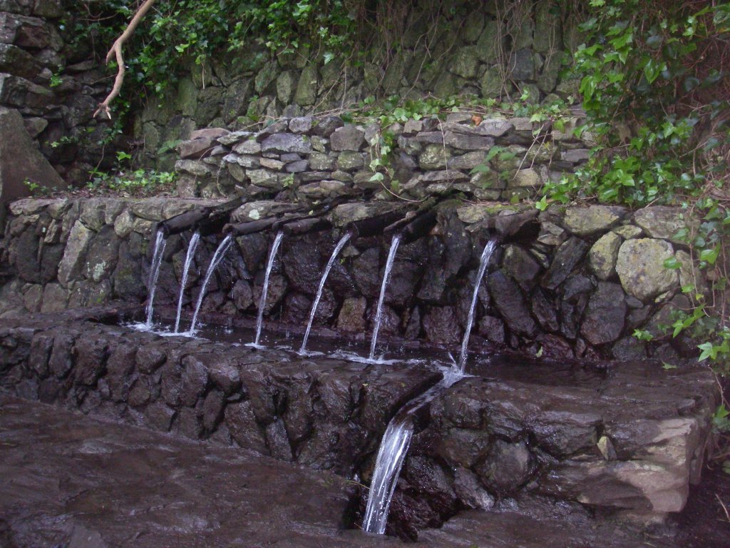
From this point, the trail ascends through a fire-tree/heath stretch that is quite lush (within the limits of the National Park of Garajonay) and has an abundance of ferns and, after about 100 m, turns to the right and leads to the well-known Chorros de Epina, a traditional fountain that is the focus of many legends; this spot has become a recreation and rest area both for the local population and for visitors.
The route continues up some stairs that lead to a terrace where we find the modest shrine of San Isidro Labrador and where the traveler can decide whether to continue his journey toward Alojera or to return to Vallehermoso along trail Stage 3.1.
To continue his journey towards Alojera, the traveler has to go around the left side of the shrine, and enter a rather dense fire tree-heath area traversed by a narrow path. After kilometer marker #54, the landscape around the road changes, and we can see to the left steep hillsides covered with heather and, to the right, rows of pines (Pinus halepensis), behind which it is possible to see in the distance the village of Epina. After passing by a water reservoir on the right side of the trail, the route continues along a narrow path that descends along the so called Cañada de las Mozas (Glen of las Mozas), with the village of Alojera and the island of La Palma visible on the horizon. Generally, this is an area that supports little vegetation due to the overuse of land for agriculture and grazing over the centuries; the ancient terraces – which we can see on the right side of the trail - have been invaded by bushes (Senecio, tabaiba…), pitas and prickly pears. On the left of the path, we can see the foothills of Ladera de los Llanos, carpeted with heather, under the rugged walls of Monumento Natural del Lomo de Carretón (Natural Monument Lomo de Carretón).
As we descend, we begin to see some palm trees again; this tree has always been associated with the landscape of Alojera and is essential for the everyday life of the local population. In this place, palm culture remains untouched, the production of palm honey being one of the most important economic activities in the region. If the visitor is lucky, he will be able to see in the afternoon how the guaraperos (laborers in charge of extracting the sap of the palm) climb up and down the trees to do their job.
After kilometer marker #55, and once we have crossed the CV-16 motorway, the path descends along a set of steps between prickly pears, palms and pitas until we meet the road again. A few meters ahead, the trail turns into a narrow track that makes its way through dense grasslands, which gradually become more widespread in this area. A little further down the trail, the traveler has to go through a private estate where he will be able to see the many crops that grow on the hillside (such as millet or potatoes), with a spectacular view of Monumento Natural del Lomo del Carretón, on the left, where a waterfall drops over the basalt walls of the hill.
After passing by Arroyo del Mono, we will reach another junction with the CV-16 motorway, and in a few meters we will fall under the spell of the striking image of the gullies of Lomo del Balo (ridge of Balo) - covered by spurge and balo plants (Plocama pendula) - towering over the small village of Alojera.
As we continue the descent, the trail allows us to appreciate how human ingenuity has been able to extract and store the scarce and precious water of the area and exploit it by means of reservoirs and irrigation systems. After passing by two of these reservoirs, we reach a road which we will follow for about 20 m in order to continue our descent to the left towards Alojera. We then reach the CV-16 motorway, and the trail goes for over 1000 m along a descending Stage of this road, which is quite steep and has numerous curves and no shoulder, so extreme caution is recommended until we reach a detour leading to the main square of the village of Alojera, where we will find an information board that marks the end of this Stage of the trail.
Profile
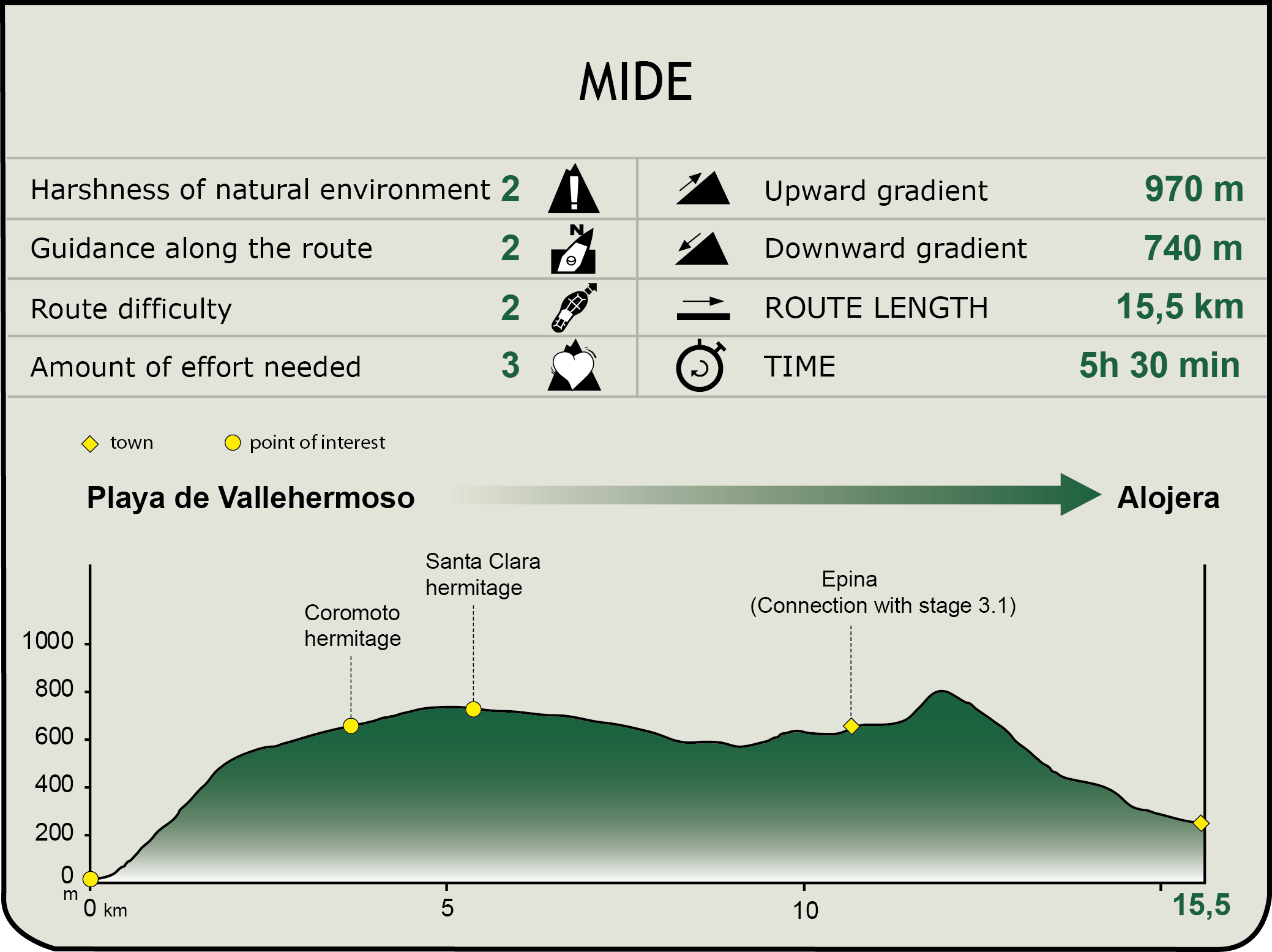
MIDE (Method for the Information of Excursions)
 Harshness of natural environment
- 1. The environment is not risk-free
- 2. There are more than one risk factors
- 3. There are various risk factors
- 4. There are quite a lot of risk factors
- 5. There are many risk factors
 Guidance along the route
- 1. Well defined trails and crossings
- 2. There is a clearly marked trail and signage
- 3. Requires the identification of geographic features and cardinal points
- 4. Requires off-path navigation
- 5. The trail is interrupted by obstacles that have to be gone around
 Route difficulty
- 1. Walking on a flat surface
- 2. Trails with different types of path
- 3. Walking on stepped paths or irregular terrain
- 4. The use of hands or jumping over the terrain is necessary
- 5. The use of hands is required to progress
 Amount of effort needed
- 1. Up to 1 hour of continuous walking
- 2. Between 1 and 3 hours of continuous walking
- 3. Between 3 and 6 hours of continuous walking
- 4. Between 6 and 10 hours of actual walking
- 5. More than 10 hours of continuous walking
Featured
Further information
Canary Islands Palm
The Canary Islands date palm (Phoenix canariensis) as it is called by the local population of La Gomera, has multiple uses on the island. Particularly well known is its use as a source of food products, such as guarapo (palm syrup) or palm honey.
Guarapo is sweet syrup extracted from the sap of the Canary Islands palm and used to produce not only the sweet beverage of the same name, but also palm honey. This syrup is a mixture of raw and processed sap with a characteristic flavor, sweet and refreshing; it is a high energy drink owing to its high concentration of minerals. The sap is collected from an incision made in the upper palm tissues after removal of the young leaves of the tree, thus obtaining a vegetal juice of high nutritional value.
The famous palm honey, obtained after steaming the guarapo, is a typical ingredient of the cuisine of Gomera, and is used by traditional Canary Islands medicine for the prevention of diseases, as well as in the preparation of desserts, cocktails or as a garnish or side for different dishes.
Traditionally, however, other parts of this plant have also been considered useful. For example, its roots were used to make ropes and espadrilles; its dried and hollowed-out trunk was used to manufacture beehives and drinking troughs for livestock; its leaves (pencas) were used as foodstuff for animals or to make hats or mats; the midrib of leaves (pirjuán) was used as fuel for roasting gofio or cooking; the fibers wrapping the palm heart (arropón) were once used as bedding for animals or for packing the bananas grown in the island; even the fruits of the tree were part of the diet of the local population in times of scarcity.
Multimedia